Guildford to Gomshall walk
Historic Guildford, The North Downs Way and St Martha-on-the-Hill Church, picturesque Shere. Option to continue along the NDW to Dorking
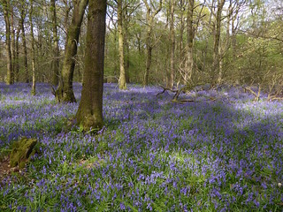
Old Simm's Copse, near Gomshall, Surrey
Apr-17 • Saturdaywalker on Flickr
swcwalks book2 walk13 walkicon banner 34204862186
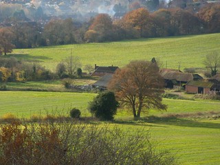
View from up top
Guildford Circular via Chantries Hill
book2 walkicon swcwalks walk13variation 3032046919
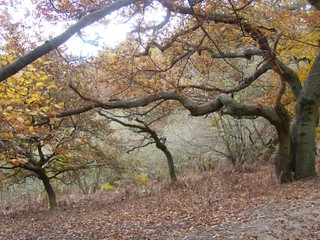
Autumn trees
Guildford Circular via Chantries Hill
book2 walkicon swcwalks walk13variation 3032048095
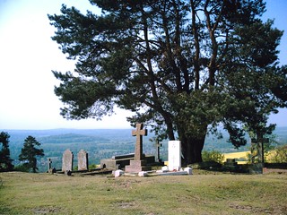
Gravestones
St-Martha-on-the-Hill D.Allen Vivitar 5mp
Apr-07 • magyardave2002 on Flickr
graveyard book2 walk13 swcwalks stmarthaonthehill 478905488

Flowerpot Men
Shere residents Bill & Ben. D.Allen vivitar 5mp
Apr-07 • magyardave2002 on Flickr
flowerpotmen billben book2 shere walk13 swcwalks 478905502


On the Pilgrims Way along the North Downs
| Length |
Main walk: 19.2km (11.9 miles) a) Short cut to Abinger Hammer: 17.2km (10.7 miles) b) Longer walk to Boxhill station: 23.4km (14.5 miles) d) Short walk to Gomshall: 11km (6.8 miles) e) Short walk to Chilworth: 6.6km (4.1 miles) f) Gomshall Circular: 9km (5.5 miles) g) Gomshall to Boxhill station: 13.2km (8.2 miles) |
|---|---|
| Maps | OS Landranger Maps No 186 & 187. OS Explorer Map 145 |
| Toughness | 5 out of 10 |
| Features |
This walk explores the lovely ridges and valleys leading eastwards from Guildford - the Surrey Hills Area of Outstanding Natural Beauty. It starts with a short steep climb out of Guildford which leads straight to the dramatic viewpoint of Pewley Down. Then it joins the North Downs Way to climb to the hilltop church of St Martha-on-the-Hill. From there the route passes through follows the Pilgrims Way along the foot of the Downs to lunch in the pretty village of Shere. Climbing up onto the downland again and following first a wooded section and then a more open one, it finally descends to the valley again where you have a choice of two village tea rooms and a riverside pub to refresh you at the end of your walk. This is a good walk at any time of year, with the sandy soils around St Martha's Hill providing a relief from mud in winter, and some fine bluebell woods in early spring. In summer the mixture of open country and woodland provides relief from the heat, and the walk is also a good one for autumn colours. |
| Walk Options |
a) Short cut to Abinger Hammer. This direct descent from Blatchford Down to Abinger Hammer trims 2km (1.3km) off the end of the walk, but misses out a nice open section of downland. It makes a total walk of 17.2km (10.7 miles). b) Longer walk to Box Hill station. By carrying on along the North Downs Way from Blatchford Down you come in 9.3km (5.8 miles) to Box Hill & Westhumble station, from which a Gomshall return is valid for return to London. From Guildford, this makes a total walk of 23.4km (14.5 miles). c) Bluebell diversion . In late April or early May it is worth making a short diversion from the main walk to visit a spectacular series of bluebell woods just behind the escarpment. This can also be combined with options a), b), f) and g) and adds only 2-300 metres to the length of any of these options. This diversion is only worth doing in bluebell time: otherwise the routes described are better. d) Short walk to Gomshall The main walk passes very close to Gomshall station just after lunch, making it possible to cut short the walk at this point. This makes a walk of 11km (6.8 miles).e) Short walk to Chilworth : For an even shorter walk from Guildford, you can walk as far as St Martha-on-the-Hill church, and then descend to Chilworth, which has a railway station and buses. This route is 6.6km (4.1 miles). f) Starting in Gomshall. You can start the walk in Gomshall and do a circular walk of 7km (4.3 miles) - or 9km (5.5 miles) if you use the option a) Short cut to Abinger Hammer as well. There are tea options but no lunch stop on this walk g) Gomshall to Box Hill station. Using option f) to start with and then switching to option b) makes a walk of 13.2km (8.2 miles). There are tea options but no lunch stops on this walk. |
| Transport |
Four trains an hour run between London Waterloo and Guildford, the fastest take 38 minutes). Take the train nearest to 9.30am from Waterloo to get to lunch at the right time. Do not get the slower stopping trains via Clandon or Effingham Junction, unless these happen to be more convenient to you. Trains back from Gomshall to Guildford run every two hours (journey time 15 minutes). Buy a day return to Gomshall, making sure your ticket is valid for ‘any permitted’ route, as a cheaper ticket is sold for return in the opposite direction from Gomshall, changing at Redhill, which is an alternative way to get back to London. If you miss the train, buses go fairly regularly (Mon-Sat only; for information, call 0871 200 2233) to Guildford from outside the Compasses Inn. Chilworth is served by the same trains that call at Gomshall. From Box Hill & Westhumble trains go hourly Monday to Saturday and twice hourly on Sundays to London Victoria: change at Epsom for connections to Waterloo. A Gomshall return is valid via Box Hill or you could try a Guildford return, adding a single for the one stop from Box Hill to Leatherhead if necessary. |
| Lunch |
The White Horse pub in Shere (tel 01483 202518), 9.2km (5.7 miles) into the walk is a rambling ancient inn with a small patio out the back, and though busy at weekends is well-run and efficient. It serves food all afternoon daily. Forty metres up the road is the William Bray (01483 202044, http://www.thewilliambray.co.uk/), which has a more modern rustic decor. It serves food all afternoon daily. A cafe option in Shere is The Dabbling Duck, open till 4.30pm weekdays and 5pm weekends, and serving hot food until half an hour before closing time. Just around the corner, on the left at the start of the lane leading to the church, is Hilly's Tea Shop, open till 5pm daily. 1.6km (0.9 miles) further on from Shere - and thus 10.7km (6.6 miles) into the walk, the Compasses Inn in Gomshall (01483 202506) is also a possible lunch stop. Open all afternoon, it does food from noon-9pm Monday to Saturday and noon-8pm Sunday and has a riverside garden. At the end of e) Short walk to Chilworth, the Percy Arms (01483 561765) is a restaurant pub with a South African tinge. It has a garden. It is open and serves food noon-3pm and 6-10pm Monday to Friday and all afternoon Saturday and Sunday. |
| Tea |
The Abinger Hammer Tea room, attached to the village shop in Abinger Hammer, is a possible tea stop for the main walk, open till 5pm daily. It has some outside tables in summer, albeit by rather busy road. The shop sells a range of snacks and homemade cakes. Otherwise, the only pub option in Gomshall is currently the Compasses Inn (see Lunch), the Gomshall Mill opposite being (as of April 2022) closed and up for sale. On options that end at Box Hill station (b and g) the best tea choice is the Denbies Wine Estate Conservatory Restaurant (01306 876616, www.denbies.co.uk), a self-service restaurant under a large glass-roofed courtyard which has an good choice of cakes. It is open till 5pm daily April to October, 4pm November to March. A pub option in Westhumble is the Stepping Stones (01306 889932), 400 metres beyond Box Hill and Westhumble station, which has a garden. |
| History |
Only a ruined keep remains today, but under Henry III Guildford Castle was a key royal residence. After Henry's death in 1272, the castle fell into disuse and was eventually bought in 1611 by Francis Carter, a local worthy, who used it as a private house. The ruins were bought in 1885 by Guildford Borough Council. It is now a park, open during daylight hours. From the top of the keep there is a fine view of the Wey river valley. The plinth on Pewley Down commemorates its gift to posterity by the Friary Brewery Company in 1920 in memory of those who died in the First World War, many of whom doubtless dreamed of views such as this during their time in the trenches. Given its dramatic situation on top of a hill on the Pilgrim's Way, you would imagine that St Martha-on-the-Hill church must have once been a stop for medieval travellers on their way to the shrine of Thomas à Becket at Canterbury. But in fact there is no evidence for this. The Pilgrim's Way turns out to have been a romantic fancy of a Victorian vicar, which was adopted with very little evidence by the Ordnance Survey: real pilgrims travelled from London to Canterbury down what is now the A2, and travellers from other parts of the country would have stuck to the valley, with its villages and inns. The church is a Victorian reconstruction, though from a Norman ruin. It is much more likely that the Pilgrim's Way and the North Downs Way were drove roads used by farmers driving sheep or cattle to market or pasture. . Shere is often cited as Surrey's prettiest village. In 1329 the anchoress Christine Carpenter (halfway between a lay woman and a nun) was enclosed in a cell in the north wall of its church, receiving food through a grating on the outside wall. After three years she returned to the world, but then petitioned to be re-enclosed. The bishop consented. You can still see where her cell was situated to the left of the altar. |
| Book |
This walk was originally published in Time Out Country Walks near London volume 2. We now recommend using this online version as the book is dated. |
|---|---|
| North Downs Way |
This walk is a stage of the North Downs Way - a 125 / 131 mile national long distance path - that follows the North Downs ridge in South East England. |
| Profile | |
| Help Us! |
After the walk, please leave a comment, it really helps. Thanks! You can also upload photos to the SWC Group on Flickr (upload your photos) and videos to Youtube. This walk's tags are: |
| By Train |
Out (not a train station) Back (not a train station) |
| By Car |
Start GU1 4UT Map Directions Return to the start: Finish GU5 9NX Map Directions Travel to the start: |
| Amazon | |
| Help |
National Rail: 03457 48 49 50 • Traveline (bus times): 0871 200 22 33 (12p/min) • TFL (London) : 0343 222 1234 |
| Version |
Apr-24 Peter |
| Copyright | © Saturday Walkers Club. All Rights Reserved. No commercial use. No copying. No derivatives. Free with attribution for one time non-commercial use only. www.walkingclub.org.uk/site/license.shtml |


Walk Directions
Full directions for this walk are in a PDF file (link above) which you can print, or download on to a Kindle, tablet, or smartphone.
This is just the introduction. This walk's detailed directions are in a PDF available from wwww.walkingclub.org.uk