Guildford to Horsley walk
Viewpoints on the North Downs ridge

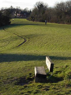
Pewley Down
Guildford to Gomshall and Guildford to Horsley walks
Feb-16 • Saturdaywalker on Flickr
book2 walk13 walkicon swcwalks swcwalk131 25403918983
Pewley Down
Guildford to Gomshall and Guildford to Horsley walks
Feb-16 • Saturdaywalker on Flickr
book2 walk13 walkicon swcwalks swcwalk131 25732971950
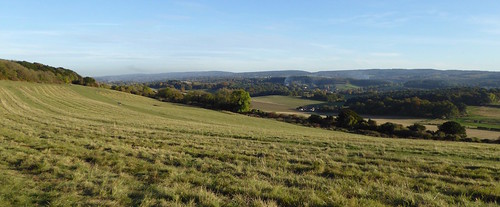
The escarpment near Newlands Corner
Guildford to Horsley walk
Oct-16 • Saturdaywalker on Flickr
swcwalks swcwalk131 walkicon 30761991235


| Length |
Main walk - 21.4km (13.3 miles) a) Shortcut to Newlands Corner - reduces walk by 3.3km (2 miles) b) Shorter start via Pewley Down - reduces walk by 1.4km (0.9 miles) c) Shortcut through the woods - reduces walk by 1km (0.6 miles) d) Diversion to Percy Arms - adds to walk 1.6km (1 mile) e) Starting from Chilworth - reduces walk by 6.3km (3.9 miles) Options b+a, b+c and b+d can be combined in the same walk. |
|---|---|
| Toughness |
4 out of 10 – a couple of extended hill climbs |
| Maps |
OS Explorer 145, Landranger 186 + 187 |
| Walk notes |
There are numerous fine viewpoints looking southwards from the North Downs escarpment, but less well known are the views to the north, where London can be seen in the far distance. This walk takes in both, starting with a climb over Chantries Hill and then carrying on to St Martha’s Church, perched high on the downs, You then descend to the village of Albury for lunch, though picnickers can miss out this descent and stay on the North Downs Way. From Albury, there is a steady climb up to Newland’s Corner, another popular viewpoint, before a wooded stretch along the North Downs Way. To finish, the walk descends through beautiful upland country to the north of the ridge, with views right to the distant City of London on clear days. You end at Horsley station, from where there are half hourly trains back to Waterloo. This is a good walk in any season, but in late April and early May Chantries Hill is awash with bluebells, and in high summer the slopes leading up to Newlands Corner puts on a fine display of wild flowers. In late autumn, this walk alternates plenty of fine leaf colour with extensive views. |
| Walk Options |
a) Shortcut to Newlands Corner. If you are not planning to eat at either of the lunch pubs (ie, if you have brought a picnic, or if you plan to eat at Newlands Corner), you can save yourself 3.3km (2 miles) by simply staying on the North Downs Way from St Martha’s church to Newland’s Corner. b) Shorter start via Pewley Down. This is the same route as is used in the Guildford to Gomshall walk, also on this website, climbing directly out of Guildford onto Pewley Down and on to St Martha's Hill. This route misses out the views and bluebell woods of Chantries Hill (though the view from Pewley Down is also quite good) and is 1.4km (0.9 miles) shorter than the main walk c) Short cut through the woods. This shorter route from St Martha's Hill to the lunch pub in Albury has become popular with some walkers. It follows a wooded ridge for most of the way, while the main walking route goes through more varied scenery. It is 1km (0.6 miles) shorter than the main walk route. d) Diversion to the Percy Arms. This 1.6km (1 mile) diversion off the route brings you to an alternative lunch pub. It also takes you past the interesting ruins of the Chilworth Gunpowder Mills. e) Starting from Chilworth. Starting from this railway station, which is just below the hill on which St Martha’s Church stands, allows you to cut 6.3 km (3.9 miles) off the start of the walk. You miss out the viewpoints of Chantries Hill and St Martha’s Hill but you pass the interesting ruins of the Chilworth Gunpowder Mill. |
| Transport |
The walk starts at Guildford station, which is served by fast trains from Waterloo every 15 minutes (journey time about 40 minutes). Ignore the slower stopping services to Guildford, which sometimes leave just a few minutes later. Take a train at around 9.30am to get to the lunch options in time, though a train half an hour later would not be a problem for faster walkers. Buy a day return to Guildford, which is valid for return from Horsley, which is on the slow line from Guildford to Waterloo. There are currently three trains an hour from Horsley Monday to Saturday - two via Cobham & Stoke D'Abernon, which are slightly faster at 49 minutes journey time to Waterloo, and one via Epsom, taking 57 minutes. On Sundays there are two trains an hour, one on each route. If starting from Chilworth you need to take a train to Guildford and change there for the Redhill/Gatwick Airport line. Buy a day return to Chilworth. Stopping trains Redhill line are only every two hours, so currently the 9.00 from Waterloo connects at Guildford with a train that arrives at Chilworth around 10.00, and the next option is the 11.00 from Waterloo, arriving Chilworth at 12.00. If you want to get to Chilworth between those times, you can take a bus number 32 from Guildford to Chilworth station (15 mins). To find the stop, follow the walk directions to paragraph 4, but instead of turning right between the navigation and the river, keep straight ahead on a bridge over the lock. Carry on down a footpath to emerge in front of the Yvonne Arnaud Theatre, with the main road beyond. Cross the main road and turn right to find the bus stop on the left in 50 metres. On Monday to Saturday the buses go at 20 and 50 past the hour currently, but see www.surreycc.gov.uk/buses for the latest timetable. Incidentally these buses also go on to Albury, stopping outside the Drummond at Albury pub (see Lunch below). |
| Lunch |
The Drummond at Albury (01483 202 039) 9.1km (5.6 miles) into the walk, or 2.8km (1.7 miles) if you start from Chilworth, is a large and pleasant pub serving both restaurant-style meals and cheaper bar classics. It has a garden with outside tables by the river. Food is served 12-3pm and 6-9pm Monday to Friday, but all afternoon on Saturday and Sunday. An alternative pub 7.9km (4.9 miles) into the walk - but requiring a 1.6km (1 mile) diversion off the route - is The Percy Arms in Chilworth (01483 561 765). Describing itself as “a country pub and grillhouse, serving modern British cuisine with a South African twist” it is more of a restaurant than a pub inside, but will serve food in its bar area as well as in its large garden. In colder or wetter weather, groups of more than eight should definitely phone to book a table. It is open and serves food 12-3pm and 6-10pm Monday to Friday and all afternoon on Saturday and Sunday. If neither of these options can fit you in, The Squirrel Hill cafe (01483 222659) at Newlands Corner, 11.2km (7 miles) into the walk, or 7.9km (5 miles) if you do the option b) shortcut, is a café/tea room which serves delicious homemade hot dishes, as well as baked potatotes, hot toasted sandwiches, salads and normal tea room fare. It has a garden with a view, though this is also next to a busy main road. The tea kiosk at Newlands Corner, to the right end of the visitor’s centre (distances into walk as for the Squirrel Hill Cafe above) is open daily except Christmas Day and serves hot drinks, cakes, and basic food such as burgers, chips and jacket potatoes “until about 4.30pm” in summer, and 4pm or earlier in winter. It seems to be popular with bikers (ie motorcyclists). There is a proposal to redevelop this site and put up a larger visitor's centre, which may affect this kiosk. For a picnic, the benches in front of St Martha’s Church (or the grassy hill just beyond it) 5.6km (3.5 miles) into the walk is one possibility, but by far the best spot is the wonderful downland escarpment at Newlands Corner, 11.2 km (7 miles) into the walk, but only 7.9km (5 miles) if you take the option a) shortcut. There are also reportedly picnic tables just behind the village hall in Albury, a little way beyond the Drummond pub. |
| Tea |
The best place is Newlands Corner – the tea kiosk or Squirrel Hill cafe mentioned in Lunch above, but this is relatively early in the afternoon of the walk. At weekends you may find a tea van in the car park in paragraph 76of the main walk directions, which serves a good range of homemade cakes. Otherwise, a possible tea stop (and the only pub stop near the end of the walk) is The Barley Mow pub in West Horsley, 1.6km (1 mile) before Horsley station. It has a garden and does tea in pots and coffee, though the barman sometimes declines to serve it. In winter note that from this pub to the end of the walk is all on tarmac – for the most part a tarmac path alongside the railway line. This path is unlit, but as long as you locate its start correctly it is perfectly easy to follow with a torch (or indeed, in moonlight). Quaich (01483 285181) (name plate currently missing, but with a blue facade, just beyond The Bakery) is a pleasant coffee shop in Station Parade near Horsley station, which has sofas, a nice range of cakes, and seems popular with the local community. It is open till 5pm Mondays to Saturdays (closed Sundays). There is also a Budgens that has quite a nice selection of pastries and also a Costa Coffee machine (coffee, but no tea sadly), open till 9pm daily. |
| Points of interest |
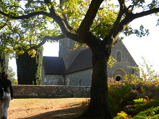
It is tempting to think of medieval pilgrims stopping at St Martha’s-on-the-Hill church on their way from Winchester to Canterbury, but there is actually scant evidence for this. The church is on what is described as The Pilgrim’s Way on Ordnance Survey maps, but this turns out to have been romantic notion of Victorian map makers rather than having any great basis in historical fact. Chaucer and his pilgrims certainly didn’t come this way – in The Canterbury Tales they were in fact travelling down Watling Street from London to Canterbury: what is now the A2. Nor is the church you see today that old – it is essentially a Victorian reconstruction of a Norman ruin. But still, it is the kind of place you can imagine medieval pilgrims might have come, and maybe that is enough. The biggest mystery of crime writer Agatha Christie’s life was not the plot of one of her novels, but what happened to her on eleven days in the winter of 1926. On 3 December that year she disappeared from her home in Sunningdale, Berkshire, and the following day her car was found abandoned at Newland’s Corner, with her coat on its back seat.The area was exhaustively searched. There were reports of “an agitated woman near the Chilworth gunpowder factory” - the ruins of which are passed on option d) Diversion to the Percy Arms - but Agatha was nowhere to be found. The press went wild with speculation. Was it a publicity stunt? Had she committed suicide? Suspicion of murder also fell on her husband, Colonel Archibald Christie, who had fallen in love with a younger woman – Nancy Neele – and told Agatha he wanted a divorce. Eventually Agatha was found registered in a hotel in Harrogate in Yorkshire under the name of Mrs Neele. She claimed to have lost her memory. She and Archibald got divorced and in 1930 she married archeologist Max Malloran. To the day she died - in 1976 - she never explained what she was doing in those missing eleven days. To the right when you are crossing the fields at the end of the walk is West Horsley Place, inherited in 2014 by the broadcaster Bamber Gascoigne and now owned by a trust. Just visible behind it is the opera house of Grange Park Opera, relocated here from its original home in Hampshire in 2017. |
| Profile | |
|---|---|
| Help Us! |
After the walk, please leave a comment, it really helps. Thanks! You can also upload photos to the SWC Group on Flickr (upload your photos) and videos to Youtube. This walk's tags are: |
| By Train |
Out (not a train station) Back (not a train station) |
| By Car |
Start GU1 4UT Map Directions Return to the start: Finish KT24 6QX Map Directions Travel to the start: |
| Amazon | |
| Help |
National Rail: 03457 48 49 50 • Traveline (bus times): 0871 200 22 33 (12p/min) • TFL (London) : 0343 222 1234 |
| Version |
Oct-23 Peter |
| Copyright | © Saturday Walkers Club. All Rights Reserved. No commercial use. No copying. No derivatives. Free with attribution for one time non-commercial use only. www.walkingclub.org.uk/site/license.shtml |

Walk Directions
Full directions for this walk are in a PDF file (link above) which you can print, or download on to a Kindle, tablet, or smartphone.
This is just the introduction. This walk's detailed directions are in a PDF available from wwww.walkingclub.org.uk