Hampden Park to Eastbourne walk
Eastbourne parks, Babylon Down (woods), Jevington, the easterly South Downs, Lullington Heath, Friston Forest, East Dean, Birling Gap, quiet approach to Eastbourne.
Tenantry Ground & Deep Dean
SWC403 - Hampden Park to Eastbourne
Mar-23 • thomasgrabow on Flickr
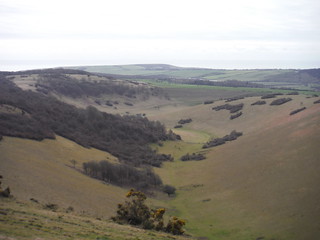
swcwalks swcwalk403 banner 52744928280
View along Willingdon Bottom to Jevington Holt
SWC403 - Hampden Park to Eastbourne
Mar-23 • thomasgrabow on Flickr
swcwalks swcwalk403 walkicon 52745003328
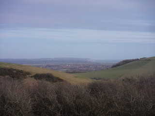
View from Holt Brow towards Hastings and the Fire Hills
SWC403 - Hampden Park to Eastbourne
Mar-23 • thomasgrabow on Flickr
swcwalks swcwalk403 walkicon 52744510451
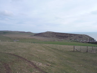
View from Went Hill to Belle Tout Lighthouse
SWC403 - Hampden Park to Eastbourne
Mar-23 • thomasgrabow on Flickr
swcwalks swcwalk403 walkicon 52743994802
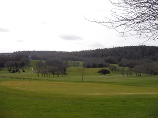
View across Willingdon Golf Club to the Downs
SWC403 - Hampden Park to Eastbourne
Mar-23 • thomasgrabow on Flickr
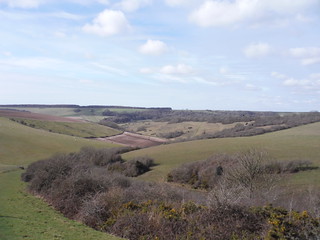
swcwalks swcwalk403 52744926655
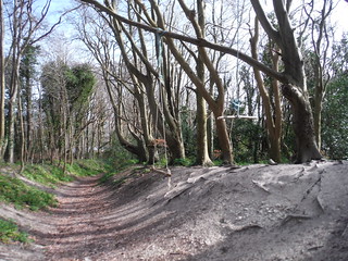
Deep Track up to Babylon Down
SWC403 - Hampden Park to Eastbourne
Mar-23 • thomasgrabow on Flickr
swcwalks swcwalk403 52745003143
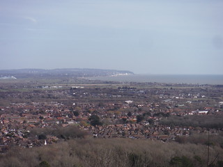
Views along the coast to Hastings and the Fire Hills, from Babylon Down
SWC403 - Hampden Park to Eastbourne
Mar-23 • thomasgrabow on Flickr
swcwalks swcwalk403 52744510631
| Length | 26.1 kms, 16¼ miles |
|---|---|
| Toughness | 8 out of 10 |
| Maps | OS Explorer OL25 (Eastbourne & Beachy Head). Landranger 199 (Eastbourne & Hastings). |
| Features |
The walk is book-ended by two of Eastbourne’s favourite playgrounds, Hampden Park and Little Chelsea. In between you contour around the woods of Babylon Down and down to Jevington. Then you climb up to the Eastern- most ridges of the South Downs, between Windover Hill and Wilmington Hill, with tantalising sea views, before turning South to the more sheltered terrain of Lullington Heath, Snap Hill and Friston Forest. You visit the twin villages of Friston and East Dean, then finally reach the sea at Birling Gap, only to immediately turn inland again, across quiet farmland to Warren Hill and the final descent in to Eastbourne. Jevington In the 1780s this was a renowned area for smuggling organised by James Pettit, known as 'Jevington Jigg', the local innkeeper and leader of a local gang. His activities were well documented in reports and newspaper accounts at the time. He stored his contraband in the inn which is now the Eight Bells. In 1788 an attempt to arrest Jigg was made by a party of armed constables as he played cards inside the inn. He escaped by quickly donning women's clothes, dashing outside, and feigning hysterics. The constables were too slow to react and he made his escape by horse. He shortly returned, but this time was captured after being discovered hiding in the loft. After various adventures he was convicted of horse stealing in 1799 and sentenced to 14 years at Botany Bay. Jevington parish church (St Andrew’s) contains Saxon elements (including a tower) as well as many other medieval architectural features, including a 14th-century font. A rare elm cultivar ‘Serpentina’ grows in the grounds. Lullington Heath National Nature Reserve Neolithic farmers cleared this area of forestry and cultivated the soil, establishing a network of fields. Excavations have uncovered pottery from as far back as 500 BC. From about 400 AD the Downs were used primarily for sheep grazing, allowing grasslands and chalk heath to develop. After World War Two, grazing was stopped to prevent water pollution. Lullington Heath NNR was established in 1955 to conserve one of the few remaining areas of chalk heath in Britain. Chalk heath occurs where acid soils are deposited on alkaline chalk. In the 1970s sheep were welcomed back, to maintain the short turf of the chalk heath. Today the NNR is a mixture of chalk heath, bushes, chalk grassland and valley grassland. Over 250 types of plant grow here and 98 bird species have been spotted, along with hundreds of different insects and other animals such as badgers, foxes, rabbit, stoats, weasels, mice, voles and shrews. A very helpful leaflet is available at the reserve and can also be downloaded from the Natural England website, including a map which marks nature trails through the site. Friston Forest In 1908 Eastbourne Waterworks Company (later South East Water) bought the downland on which Friston Forest now stands. Planting of the Forest to protect Eastbourne’s water supply was started in 1926 by the Forestry Commission who leased it from the water company. The intention was to establish a beech forest with conifers as protection. The conifers, which grow much faster than the harder beechwood, were successively cut down and sold for pulp as the beech flourished. The Forest is now almost pure beech with patches of pine and sycamore. |
| Walk options |
This is a long walk, so you probably won’t want to lengthen it! The easiest way to reduce the distance would be to divide it in to two stages, taking advantage of the excellent 12X/12/12A bus service which runs very regularly to Eastbourne and to Seaford/Brighton. You can catch the bus from either Friston Pond or East Dean. Note also that bus 13X runs via Birling Gap on Sundays (but only three return journeys a day). More direct options from Jevington to Friston Forest are described in the text. Note that if you go this way you miss out on the exhilarating hill walking in Section 3. Other options are possible by taking the path West at GR553018 (as described in the text). Again these options avoid the best of the hill walking, but you do see more of Lullington Heath Nature Reserve. You might wish to use the time saved by taking one of the above options to extend the walk later on! For example as noted in the text, from either Crowlink Lane (Friston) or Went Way (East Dean) it is possible to access the Seven Sisters via Flagstaff Brow. This route then takes you over three of the sisters, Flat Hill, Baily’s Hill and Went Hill, before rejoining the main route at Birling Gap. From Birling Gap, this walk takes a lonely inland route, but if you inexplicably prefer a crowded coastal alternative via Beachy Head you could follow the directions in #cw2.28 Book 2 Walk 28, Seaford to Eastbourne. This does mean a final stretch along the busy seaside promenade, so a good alternative would be to divert inland from Beachy Head (avoiding the very steep descent), following the directions in #cw2.27 Book 2 Walk 27b, Berwick to Eastbourne via Beachy Head, in reverse from Beachy Head to the 4-armed footpath sign mentioned early in those directions (the same signpost as at the start of Section 5 of this walk), then using the directions in this walk. |
| Travel |
Hampden Park (TQ607022) and Eastbourne (TV610992) are both in East Sussex. There are direct trains from London Victoria to Eastbourne (via Clapham Junction, East Croydon and Gatwick Airport) every 30 minutes Monday to Saturday and every hour on Sundays, average journey time 85 to 90 minutes. Hampden Park is the last station before Eastbourne and is served either on the way in to Eastbourne or on the way out. From London buy a day return to Eastbourne. |
| Lunch |
|
| Tea |
The cafes which follow are all on or adjacent to Grove Road (under 400 metres from Eastbourne station) and they are listed below in the order that you pass them, heading towards the station. The majority are on your right; those which are on your left are identified below.
|
| Profile | |
|---|---|
| Help Us! |
After the walk, please leave a comment, it really helps. Thanks! You can also upload photos to the SWC Group on Flickr (upload your photos) and videos to Youtube. This walk's tags are: |
| By Train |
Out (not a train station) Back (not a train station) |
| By Car |
Start BN22 9ND Map Directions Return to the start: Finish BN21 3QJ Map Directions Travel to the start: |
| Amazon | |
| Help |
National Rail: 03457 48 49 50 • Traveline (bus times): 0871 200 22 33 (12p/min) • TFL (London) : 0343 222 1234 |
| Version |
Apr-24 Mike Powell |
| Copyright | © Saturday Walkers Club. All Rights Reserved. No commercial use. No copying. No derivatives. Free with attribution for one time non-commercial use only. www.walkingclub.org.uk/site/license.shtml |


Walk Directions
-
A) Hampden Park to Butts Lane (3.7 kms)
- Leave Hampden Park station from platform 1 via the footbridge and turn left on Mallard Close (signposted 'to the Park'). In 140 metres turn right on tarmac before the road turns right. Cross over a footbridge and in 120 metres turn right, following a wooden signpost for Hampden Park. In 10 metres turn left. In 40 metres pass Park Practice on your left, with a stream soon running to your right. In 120 metres cross a minor road with David Lloyd sports centre to your left.
- In 40 metres go over a footbridge into Hampden Park, entering dense woods. In 120 metres ignore a signpost pointing left. In 40 metres ignore another signpost pointing left (to the cafe and toilets).
- In 80 metres you pass to the right of a tennis court on a rough path. In 50 metres turn left at the corner of the court, with Hampden Park Drive close by on your right (beyond a ditch). In 100 metres take a wooden footbridge over the ditch and in 45 metres cross the road. Follow the grass to the left, towards the War Memorial. In 55 metres turn right by the War Memorial (on the furthest right path). In 70 metres, with a lake ahead, you turn right, then in 25 metres turn left at a wooden signpost (towards Decoy Drive), on a wide path with the lake to your left and a line of seats on your right. At the end of the lake in 120 metres, ignore the small footbridge to your left and continue ahead, now with a stream to your left. In 60 metres cross a drive and continue to the right of a green bin, on tarmac. In 80 metres keep to the right of a smaller pond. In 100 metres turn left on the busy Decoy Drive (where there were building works in 2022).
- In 120 metres cross the main A2021 ahead and continue opposite (a little to the right) on Park Lane (no pavement). In 250 metres you pass the entrance to Ratton School on your left. In 200 metres turn left on the A2770 opposite Ratton Drive. In 30 metres cross the road and take the path opposite, with signs for Willingdon Hill, Jevington and Friston. In 5 metres go through a metal gate and continue uphill with residential fences to both sides. In 300 metres there are grand houses immediately to your right and in 40 metres a golf course comes in to view on your left. The path turns to the right in 280 metres and in 25 metres you turn left, still uphill, on The Linkway, a minor road, by a wooden public bridleway signpost. In 30 metres you pass South East Water's Ratton Booster. In 45 metres you pass to the right of a signpost, with a blue arrow pointing you to Willingdon Hill and Jevington. Take the narrow, steep, well-shaded path (a stream bed after rain). In 200 metres ignore the bridleway to the right (marked Jubilee Way, 2012).
- In 100 metres you reach a wooden signpost, pointing in several directions. Slightly counter-intuitively take the public bridleway which is sharply to your right. This soon contours round to the left (320°). In 150 metres you start climbing steadily again, on a wide path. Ignore all minor forks off. In 100 metres the path narrows and turns to the left, with excellent views to the sea as far as Hastings. This area is called Babylon Down. In 350 metres go through a metal barrier and turn left on Butts Lane (you can avoid the road altogether by veering left just before the barrier). In 80 metres you reach the Butts Brow Car Park.
-
B) Butts Lane to Jevington (1.9 kms)
- Turn right in to the first section of the car park. Pass to the left of a pay and display machine, where there is a kissing gate and signpost for ‘Jevington, 1½ miles’ (i.e. do not go through the gate here). Continue on gravel through the car park, and in 40 metres keep to the right of a wooden barrier. In 25 metres go through a wooden gate into access land, following the public bridleway sign (240°). Continue downhill on an open grassy slope, with a wire fence to your left and wide views in all directions. Go through a metal gate in 550 metres, leaving the access land. The path levels out, now with a wire fence on your right. In 140 metres ignore the stile on your right. In 180 metres the path curves to the left. In 120 metres you go through a wooden field gate. In 300 metres ignore a footpath to your left and another stile to your right.
- In 60 metres keep to the right of a metal field-gate. In 20 metres go through a wooden gate on to a narrow, shaded path, with a field below on your left. In 90 metres go through another wooden gate and continue on grass. The path soon curves to the right and the houses of Jevington come in to view. In 200 metres go through a gate and continue on Willingdon Lane. You reach the main road (Jevington Road) in 150 metres.
-
C)Jevington to Lullington Heath (4.1 kms)
- Here you have a choice Turn left for the first short cut option at the end of this section
- For the main route turn right on Jevington Road. In 15 metres turn left on Church Lane, with a South Downs Way (SDW) sign for Alfriston, 4 miles (but for the Eight Bells, continue along the road for 200 metres).
- In 180 metres you pass St Andrew’s Church on your right and another sign alleging that it is now just 3 miles to Alfriston! Continue on a wide track, gently uphill, with paddocks to your left. In 350 metres the path turns to the right (North-West) at the end of the paddocks, climbing more steeply now. In 200 metres you cross another path at a wooden signpost, still on the SDW. In 60 metres keep left at the next path junction, still climbing on the SDW. In 300 metres turn right at a wooden SDW signpost (GR553018 – note that continuing ahead here enables more direct routes to Lullington Heath, see short cut options at the end of this section). In 80 metres go through a wooden gate to open grassland, with a wire fence to your right at first and woods beyond. In 350 metres go through a wooden gate by a field-gate, with the ruined buildings of Hill Barn visible ahead to your right. The sea is visible both behind you and to your right beyond woods to Hastings; on your left you can see the radio masts on Beddingham Hill in the distance. The path veers to the right (North), then in 400 metres to the left at an SDW post (away from Hill Barn and away from the fence).
- Ignore all marker posts and ways off until in 720 metres you reach a 3 armed wooden signpost in the fence ahead; take the sharp left fork here, leaving the SDW by a wire fence on the edge of a scenic down ('Tenantry Ground' on the map). Continue South and gently downhill with the steep sided valley on your right. The path curves to the right (i.e. South-West). Go through a wooden gate in 850 metres. Continue on a wide path of grass and gravel, with woods below to your right. On the right you can see the church spire and some houses in Alfriston, and ahead on the right High-and-Over Hill, often frequented by hang gliders. In 450 metres you pass to the right of a Lullington Heath Nature Reserve information board. and continue on a wide track between wire fences (250°). In 200 metres the track curves to the right; leave it here and cross the grass ahead.
-
Short cut alternatives via Lullington Heath
- Note that the following options miss out on the exposed high level walking of the main route, but they may appeal in windy conditions or poor visibility.
- Turn left on the main road in Jevington. In 60 metres turn right on The Pentlands. In 45 metres take the bridleway to the right of a field-gate, uphill and tree-lined with paddocks to both sides at first, then barbed wire fences and fields beyond. Climb steadily to enter woods in 850 metres at the top of the climb by a memorial seat. Ignore the path to the right and continue ahead on a wide bridleway (240°), now gently downhill. In 200 metres cross a path and continue past a post with blue arrows. In 580 metres the path levels out again, with a steep drop to the right. You pass another blue arrow post and ignore a path to your right. In 200 metres you reach another post with blue arrows at a cross-paths. Turn left here to rejoin the main route at the start of Section E. Note that this option reduces the overall distance by 4 kms.
- Alternatively, stay with the main route as far as the signpost at GR553018, then continue ahead (generally West) where the main route turns right, on a wide track with wire fences to both sides. In 220 metres ignore a path to the left (this is an alternative route to Lullington Heath). In 280 metres you reach a gate on the left in to Lullington Heath National Nature Reserve (NNR) at GR549018. From here there are alternative routes through the NNR, using either a nature trail or a right of way. The first two paragraphs below describe the nature trail, the next two the right of way. Note that the two routes cross each other, so you can easily move from one to the other, e.g. a good option would be to follow the first paragraph below (nature trail), then switch to the fourth paragraph below for the right of way option, which avoids a steep climb.
- For the nature trail, turn left at GR549018 and in 5 metres go through the wooden gate in to the NNR, with fire beaters and leaflets on an information post (you can return the leaflet when you leave the NNR shortly). Note the green number 1 on a black post, which relates to the NNR map. The path curves to the right and left, then reverts to 250 degrees again. In 150 metres you pass a wooden bench to your left and continue on a wide track, making for a gap between the bushes ahead (South-West). In 450 metres ignore a stile to your right. In 35 metres go through a gate next to a field-gate, leaving the Access Land. In 15 metres turn right at a post indicating Point 2 on the NNR map and more fire beaters and leaflets. In 80 metres ignore a stile leading to the enclosure to your right. In 60 metres pass a metal trough to your left and continue downhill on a wide grassy path with a wire fence to your right. In 100 metres you reach a path junction, with a post indicating paths to the left and right. If you wish to revert to the right of way route, turn left here and ignore the following two paragraphs.
- To continue on the nature trail, take the metal gate immediately ahead (note the green number 3 on a black post). Continue uphill (300 degrees) with a rough hedgerow to your right and woods to your left. In 320 metres turn left at a bridleway post, with arrows pointing left and right, joining the main route at GR538016 in Section D (there is a leaflet box just to your right).
- For the right of way option, from GR549018 (point 1 on the NNR map) ignore the gate to the left and continue downhill on the wide track. In 400 metres turn left at a 3 armed wooden signpost (GR546018). In 5 metres go through a gate by fire beaters in to the NNR, with signs about pony grazing. The grassy path goes gently downhill (230 degrees) between bushes. It makes a wide turn to the left, South then more South-East. In 850 metres go through a wooden gate with more fire beaters. In 25 metres there is a post and a gate to the right (note the green number 3 on a black post). At this junction you can go through the gate and revert to the nature trail route as immediately above.
- To stay on the right of way, continue gently downhill on a wide grassy path, with woods away to your left and right. In 550 metres, keep to the right of a post. In 320 metres go through a gate at a perennially wet area, or (better) through the gap to its left, where once was another gate! Turn left on the main route at 543007 in Section D.
-
D) Lullington Heath to Friston Forest (Snap Hill) (1.8 kms)
- In 20 metres you pass just to the right of a 4 armed signpost. Take the public bridleway ahead, just to the right of another information board. Continue South, with a wire fence and a field on your right. In 300 metres you pass railings on your left enclosing a box, which houses a device which monitors air pollution levels (so stub out any cigarettes)! In 40 metres continue downhill past a post with a blue arrow (GR538016 – note that the nature trail route through the NNR uses the path on your left, see short cut options above).
- In 140 metres you enter woods (Friston Forest) and the path narrows. In 350 metres you pass another post with a blue arrow. The path continues down through the dense and eerily quiet forest, always heading South or South-East. There is a steep drop to your left. The path widens to pass another blue arrow on a post in 500 metres. In 25 metres, at a staggered multi-track junction, bear left then cross a track and bear right steeply uphill in a South Easterly direction, ignoring a metal field gate (or gates) on the left (GR543007 – note that the right of way through the NNR uses the path on your left, see short cut options above).
- Climb steeply, passing to the left of a small pond (hidden in the woods, but shown on the map) in 160 metres. Cross another path at a blue arrow on a post in 100 metres. At the next cross paths in 150 metres, again marked by a post with blue arrows, the short cut from Jevington joins you from the left.
-
E) Friston Forest (Snap Hill) to East Dean (3.3 kms)
- [Shortcut rejoins] The path levels out on Snap Hill, with tall trees to both sides. You pass the first of several Mountain Bike Trail (MTB) signs on your left. In 180 metres you start to descend. In 150 metres cross another MTB path (with a red sign on the reverse). In 420 metres cross a wide track at another post with blue arrows (fallen in early 2024) and start to climb again. In 120 metres the path levels out as you pass another red MTB sign.
- In 160 metres continue due South, past another red MTB sign. The lower ground is now on your right and as you emerge on the open hillside in 220 metres there are wonderful views of the hills ahead across a grassy U-shaped valley, with some houses in Friston (encountered shortly) visible on the far side. After another blue arrow on a post, pass between wire fences (160°) and steeply downhill. In 180 metres you enter dense woods, still steeply downhill. In 100 metres cross a wide track and continue downhill on a narrow path, ny another MTB sign.
- Follow the path round to the left, with a tarmac road parallel on your right. In 80 metres the path turns to the left again but you cut through to the minor road. In 15 metres turn left with a stone wall on your right and the buildings of Friston Place visible beyond. In 200 metres go up three steps to the right of the road and through a wooden gate at a gap in the wall. Cross a field due South following the wooden public footpath signs. In 150 metres go through a gate in another wall, down some steps and cross a drive.
- In 20 metres go over a stile and bear left uphill across the next field on a clear grass path, with a large house visible above to the left near the end of the field. In 250 metres, go over a stile and up a stepped path. In 150 metres turn left through a metal gate. Shortly there is a paling fence on your left. Go through a metal gate on your left in 150 metres.
- Cross a grass triangle then cross the main road (A259) in 30 metres (you can pick up a frequent bus from here to Seaford, Brighton or Eastbourne).
- Take Crowlink Lane opposite, with the church on your left and Friston Pond on your right (note that the lane becomes a path leading to the Seven Sisters via Flagstaff Brow – see ‘Three Sisters’ options from Friston or East Dean below). For the main route, in 40 metres go through the curious rotating gate in to the church yard. This is a Tapsell Gate, which is unique to this part of East Sussex (both Jevington and East Dean churches have similar gates). They were designed to keep out livestock, but also played a part in funeral and marriage customs. Pass to the right of the church in 30 metres. Go through a gate with a yellow arrow in 40 metres and another in 30 metres. Head downhill on the grass towards the houses of East Dean, with the main road close by on your left at first. This is Hobb’s Eares. In 450 metres go through a wooden gate by a field-gate and continue on a minor road. You pass Farrer Hall (which has a rich history) on your right in 35 metres and turn right on Upper Street in 35 metres. In 50 metres you reach the village green, with the Thai Terre restaurant on the right, followed by The Beehive on the Green cafe, and the Tiger Inn across the green beyond the War Memorial 50 metres on the left, with The Hikers Rest Coffee Shop to its right. There is also a blue plaque on the first cottage on the left, claiming it to have been the retirement home for the fictitional detective Sherlock Holmes.
-
Alternative ‘Three Sisters’ options from Friston or East Dean
- From Friston Church, ignore the Tapsell Gate in to the churchyard and continue on Crowlink Lane, with houses to left and right. In 250 metres, just after Paynes Dene (house) on your right, go through a gate on the left with footpath and bridleway arrows, immediately before a National Trust sign for Crowlink. Cross the field half right (150 degrees) making for a wooden gate visible in the wire fence ahead. In 300 metres go through the gate and turn half right, 260 degrees (the route from East Dean joins you here - ignore the next paragraph and continue below).
- Alternatively, from Went Way, East Dean, take the path by Meadow Cottage, opposite a public footpath sign. You go up steps and in 60 metres through a metal gate. Continue on grass, uphill with a stone wall to your right and wide views to your left including Belle Tout lighthouse. In 150 metres, before a seat visible ahead, fork right towards the wall. In 10 metres go over the wall using some stone steps. Turn half left (from the wall, i.e. 260 degrees) in a field, following the wire fence and rough hedgerow on your right. In 140 metres, at the end of the fence, continue across the field with no clear path, making for a wooden gate. In 160 metres go through the gate and continue in the direction of an arrow pointing half right (joining the route from Friston).
- Head towards the left hand end of a small group of trees (to the left of a longer line of trees which are further to the right). On reaching the trees in 275 metres, the houses of Crowlink and the lane are visible below (ahead to your right). Turn slightly left from here (South-West), parallel with the lane (and hedge) on a faint grassy path which is shown as a Right of Way on older maps, but marked in black on the most recent online versions. The path becomes clearer, with the sea ahead and a slight dip just to your right. Make for a wooden gate which comes in to view in the fence ahead. In 700 metres you go through the gate, which has a yellow footpath arrow. Continue gently descending towards the sea, making for a small stone monument visible in the distance. In 450 metres go through a small gate (with the low Sarsen stone monument on Flagstaff Point just ahead) and turn left on the South Downs Way.
- Keep straight on along the clifftop path towards Birling Gap, whose buildings are visible ahead. You pass over three more humps in the next 1.6 kilometres – one minor one – Flat Hill - and two major ones – Baily’s Hill and Went Hill. 170 metres after the summit of Went Hill you pass through a wooden kissing gate, rejoining the main route where noted in the text in the last paragraph of section F.
-
F) East Dean to Birling Gap (2.0 kms)
- Retrace your steps from the Tiger Inn across the green to Thai Terre, turn left on Upper Street then fork right on Went Way (where Lower Street descends to the left). In 25 metres you pass a plaque about wartime evacuations. In 35 metres ignore the path to the right by Meadow Cottage (but note that this path provides access to the Seven Sisters via Flagstaff Brow - see ‘Three Sisters’ options from Friston or East Dean above).
- For the main route, follow the road round to the right in 150 metres. In 60 metres go through a metal field-gate, by a public bridleway signpost. Continue uphill on grass. In 160 metres go through a wooden gate with a National Trust sign and information about Went Way, an ancient track from Birling Gap to Willingdon. Continue uphill on the wide track, passing a memorial seat in 120 metres. In 25 metres you emerge on the open hillside. Continue to a wooden post in 30 metres then turn left (South), making just to the right of a stone building with a seat outside (known locally as the Red Barn). You pass another post with a blue arrow in 250 metres, then to the right of the building in 90 metres (the right of way is to the left here but there is a clearer slightly sunken track to the right).
- There are excellent sea views as you continue downhill on the wide grass path, with houses ahead to your left. In 480 metres go through a wooden gate and continue down the left edge of a field. In 160 metres go through a wooden gate out of the field, with a National Trust sign for Went Hill. Continue on gravel past the houses on your left. In 70 metres ignore the gate and path to the right (but note that the Alternative ‘Three Sisters’ options from Friston or East Dean join you here, see above). In 250 metres you pass a pedestrian entrance to Birling Gap cafe on your right. In 40 metres keep to the right of the road (Birling Gap Road/Beachy Head Road) with the main car park to your right.
-
G) Birling Gap to Warren Hill (5.6 kms)
- Cross the grass to the right of a bend in the road, in to a second, smaller car park. Immediately turn left following the ‘way out’ signs. In 70 metres continue past the end of the car park on a grass path which runs parallel with the road. In 90 metres the path divides. Take the higher path through a metal gate in 40 metres, continuing level and parallel with the road below. In 420 metres you go through a metal gate and a National Trust sign tells you that you are leaving ‘The Lookout’.
- In 100 metres you see a car park below, to the left of the path. You enter woods in 80 metres and leave them in 120 metres. In 250 metres you draw level with a concrete road leading to Cornish Farm to your left and directly above you is Belle Tout lighthouse.
- [!] In another 180 metres, where the path starts to veer right (towards Beachy Head) there is a metal gate visible on the other side of the road (Beachy Head Road). Take the path down to the road and go through the gate in 40 metres. There are no signs here. Bear right along a faint grass path towards some buildings and trees up on a rise (85°). Go through a shallow dip, i.e. downhill at first, then uphill. In 350 metres you reach the corner of a wire fence on your right and continue with the road now parallel to your right.
- In 100 metres there is a stone wall to your right and in 120 metres you continue past Hodcombe Farm behind the wall, still at 85°. In 100 metres you pass Hodcombe Farm behind a stone wall and and in 100 metres you continue ahead at the far end of the wall, still on 85°. In 420 metres go through a metal gate where there is a highly informative 4 armed signpost, in contrast to the previous junction! Ignore the stile ahead and turn left, back towards East Dean, going uphill on a wide grassy path between wire fences. In 280 metres at the top of the climb go through a wooden gate, ignoring the path to the left and continue in the next field with a wire fence to your right. Curve to the left around a depression, then follow the right-hand boundary fence, but after 150 metres in the field, stay to the left of a thick area of wind-beaten low trees, descending into Kiln Combe. You go through a wooden gate in 60 metres and in another 25 metres you pass the corner of the fence on your right, still going downhill.
- In 50 metres you start to climb again on grass (340°, later 320°). There is a field boundary to your right here, but it may only be marked by temporary fencing. At the top of the climb (Long Down) in 220 metres go through a wooden gate with a blue arrow and immediately turn right on a wide grass strip, with a wire fence parallel to your right, still gently uphill.
- [!] In 680 metres you reach a metal gate next to a field gate. Turn left (by an Eastbourne boundary stone) and downhill immediately before this (the path is not marked here), with a wire fence on your right (340°). At first the path is very rough and possibly overgrown. In 100 metres go over the stile to your right and continue steeply downhill with the wire fence now on your left. There is a stone public footpath marker here and the way is much easier. In 140 metres turn right at the corner of the field on a wide grassy path (this is East Hale Bottom).
- In 260 metres you pass a building and a pond to your right, by a blue arrow on a post. Turn left here and go through a gate in 10 metres. Continue ahead (10°) on a wide grass path with wooded hillside to your right. In 300 metres you pass to the right of a wooden gate and continue in the next field. In 250 metres the path curves to the right (following the wire fence on your right).
- In 580 metres go through a wooden gate next to a field gate, then veer right towards a armed signpost visible ahead. In 60 metres cross the busy B2103 (Warren Hill).
-
H) Warren Hill to Eastbourne (3.7 kms)
- From the signpost there are wide views of Eastbourne and (possibly) an ice cream van and a seat to your right. Follow the path half left, signed for Paradise Drive and Willingdon, heading towards more seats (20°). In 130 metres (well before the seats, which surround a triangulation pillar and dew pond familiar from other walks, and also before a signpost) cut across downhill to the right, towards a path visible just below. In 20 metres cross a path and continue on the wide grassy path ahead (80°) very gently downhill. The ground drops steeply with dense bushes to the right, towards built-up areas and the sea. Ignore all turnings off.
- In 390 metres at a wide grassy clearing there is an unmarked junction with a wide path to your left, and the corner of woods ahead on the left (this is also the junction with Walk 2/27, Berwick to Eastbourne). Keep right here (100 degrees) on a narrow dirt path, away from the woods to your left and still with more woods on your right, heading just to the right of a conspicuous tower block ahead. In 130 metres cross a footpath (shown on the map as a Right of Way), with marker posts visible to left and right. In another 125 metres you pass two concrete footpath and bridleway signs on the ground on your left. Keep right here, to the right of bushes (to the left is a fenced off covered reservoir, marked on the map).
- Your wide grassy path turns to the left (East, then 60°), with houses reassuringly close by on your right.
- In 600 metres you reach the foot of the grassy slope and turn right on Paradise Drive, by the junction with Link Road to your right. In 200 metres (after the junction with Carlisle Road) turn left on Gaudick Road, by a post box. At the end of the road in 130 metres, go through a gate in to Royal Eastbourne Golf Course.
- In 25 metres, you reach the first of a series of high posts with yellow arrows, marking the two paths across the golf course. Take the right hand path (not the one leading towards sports fields) at 10°. Each marker post is visible from the previous one. Be warned though that the first fairway is played from the left (the others, from the right). In 100 metres you pass the next post, in a strip of trees. In 45 metres pass a post at a fairway and continue slightly to the right (30°). In 90 metres pass another post, with a wall below to your right (Compton Place). In 160 metres pass another post between small trees. The clock tower on Eastbourne's Town Hall is visible to your right. In 150 metres you pass a post to the right of a tee, then turn to the right, passing sheds on your left in 40 metres. After the sheds turn left, down steps in 50 metres.
- In 20 metres cross the circuitous Paradise Drive again, at the junction with (not named here) Borough Lane. Continue down Borough Lane, passing school playing fields to your left, then turn right at the first opportunity in 80 metres, going round a barrier in to Gildredge Park in 80 metres. Cut across the grass half right (in wet conditions you can stay on the tarmac and turn right ahead, passing the public toilets - the park cafe is visible beyond) to leave the park by a yellow vehicle barrier in 180 metres. Cross Dittons Road in 60 metres and continue down Saffrons Road (the Saffrons, home of Eastbourne cricket ground, which is occasionally used by Sussex CCC, is behind the high wall which is shortly to your right).
- In 340 metres ignore Old Orchard Road on the left (though this quiet residential street is the most direct route to the station). For a more interesting and altogether LOUDER finish, with lots of refreshment opportunities, continue to the end of Saffrons Road in 120 metres, with Our Lady Catholic Church opposite you and Eastbourne’s imposing Town Hall on your left, then turn left on Grove Road. Together with South Street, which you pass on your right in 25 metres, this is Little Chelsea, a popular shopping area with an eclectic range of cafes, listed in the tea section of this walk.
- Stay on Grove Road past the junction with South Street. In 350 metres turn right on Terminus Road. Cross the road in 50 metres for Eastbourne station, which you reach in a further 50 metres.