Hayes Circular walk
A short walk across three commons in South East London


| Length | 9.5km (6m) |
|---|---|
| OS Map | Explorer Maps 162,147, 161. The walk is in the corner of all three maps. |
| Toughness | 1 out of 10 |
| Features | This short walk crosses three commons which have been used for hundreds of years as a source of wood as evidenced by the many coppiced trees. Today coppicing is still practised but the mix of woodlands also provides habitats for a variety of animals. The walk follows in part the River Ravensbourne which fills the three Keston ponds straight from its source and flows into the Thames at Deptford as Depthford Creek. Charles Darwin who lived nearby in the village of Downe, carried out parts of his research on Keston Common. On the way you get a glimpse of Ravensbourne Lodge previously owned by the Bonham-Carter family. The most ancient remains encountered on this walk are from the iron age around 200BC. The walk was inspired by the marked Three Commons Circular Walk and broadly but not exactly follows it. The walk crosses several roads some of them quite busy. Cross them with care ! |
| Travel | Take the train nearest to 10:00 from London Charing Cross to Hayes (Kent). Hayes (Kent) is in Zone 5 and Oyster Cards can be used. |
| Lunch | All lunch options are very popular, hence you should book if there are more than 4 people.
|
| Tea |
|
| Profile | |
|---|---|
| Help Us! |
After the walk, please leave a comment, it really helps. Thanks! You can also upload photos to the SWC Group on Flickr (upload your photos) and videos to Youtube. This walk's tags are: |
| By Train |
Out (not a train station) Back (not a train station) |
| By Car |
Start BR2 7EN Map Directions |
| Amazon | |
| Help |
National Rail: 03457 48 49 50 • Traveline (bus times): 0871 200 22 33 (12p/min) • TFL (London) : 0343 222 1234 |
| Version |
Apr-24 Dirk |
| Copyright | © Saturday Walkers Club. All Rights Reserved. No commercial use. No copying. No derivatives. Free with attribution for one time non-commercial use only. www.walkingclub.org.uk/site/license.shtml |


Walk Directions
The directions for this walk are also in a PDF (link above) which you can download on to a Kindle, tablet, or smartphone.
- Cross the road in front of the station and walk up Station Hill. In 100m turn right following Station Hill.
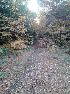
- In 140m cross a road into Hayes common and walk towards the far left corner of the open space near a bench. Once there, follow a path into the woods marked Three Commons Circular Walk (3CCW).
- In 60m cross Preston Road.
- In 180m go straight across a 4 way junction.
- In 210m, 20m after a bench on your right, veer left with the path where another path joins from the right.
- In 90m at a 4-way junction turn left keeping the residential area on your left.
- In 90m turn left at a T-junction.
- In 60m cross West Common Road and continue in the same direction.
- In 220m at a 4-way junction turn right following the 3CCW sign.
- [!] In 50m leave the marked path and turn right onto a small track. A juvenile oak grows almost in the junction.
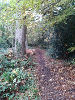
- In 130m take the right fork. An oak tree sourrounded by holly towards the right path marks this spot.
- In 110m, where the path skirts around an oak-birch tree pair, ignore a path on the right.
- [!] In 50m at an indistinct 4-way junction, marked by the last pair of birch trees on your left with a gall about 2m from the ground on one of them, turn left. If you reached a car wide track you have gone too far. Turn back about 40m.
- In 100m ignore the small path on your left. In a further 40m the path veers left at a birch. If you face a ditch with a path in it, you have gone too far. Go back about 20m. In 250m you are back on the 3CCW and turn right.
- In 20m cross a bridlepath through wooden barriers.
- In 50m cross Baston Road.
- In 160m ignore the small path towards the right and fork left.
- In 270m cross Croydon Road.
- In 160m enter an open space and in 30m turn left at the signpost adjacent to two bushes. A bench marks the direction.
- In 110m, where you reenter the woods, cross a path, then veer slightly left and then right with the path.
- In 50m at a 5-way junction take the second path on the left following the 3CCW sign.
- In 150m cross the road called Commonside and enter Padmall Wood through a kissing gate.
- In 60m take the left fork at an information board.
- Follow the path over boards made from sweet chestnut wood (crossing the River Ravensbourne for the first time) and in 400m fork right. The area on your right along this path has been completely cleared in 2019 and you can now follow the regrowth of this patch of woodland.
- After crossing the Ravensbourne, turn left.
- In 40m turn left again recrossing the Ravensbourne and then turn right at a gnarly oak tree following the Ravensbourne upstream.
- In 70m veer left ignoring the first bridge across the stream and in 20m turn right across the stream at the second bridge.
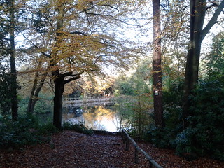
- You pass a pond on your left hand side beyond which you can see Ravensbourne Lodge through the trees. In 250m turn left uphill towards the first of the three Keston Ponds where you turn right along the pond.
- At the next corner of the pond turn left towards Fishponds Road which you cross.
- Follow the right hand edge of the second pond and walk up the steps at the end of this pond towards the next.
- At the third pond turn left and walk around its left hand edge.
- At the far end turn right and cross Caesar's Well the source of the River Ravensbourne. Walk up the steps and after the first 7 steps turn right. Continue keeping the wooden fence on your right away from the car park on your left.
- 30m after the end of the wooden fence turn left uphill into an open space skirting its left hand edge. When you see a gap between the woods and a clump of small trees on your left walk through it towards a coppiced birch.
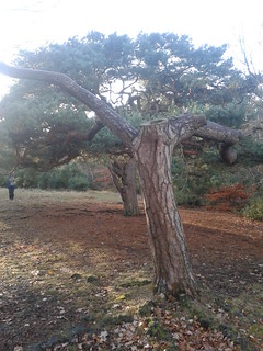
- Pass two pine trees (the first one just a hollow trunk with some branches) and pick up a well defined path beyond the pine trees between heather.
- In 160m at a tree trunk in the path used as a signpost turn left entering Keston Common. On the left hand side are the remains of an iron age mound and ditch and on the right an open space of heather and gorse.
- In 90m at a 4-way junction turn right and in 50m cross a 4-way junction at an information board.
- In 60m turn right at an oak tree and a bench.
- In 60m at a 4-way junction turn left.
- In 70m at a T-junction turn right.
- In 100m ignore a path going off to the left.
- In 150m ignore the path forking left and in just another 20m cross a 4 way junction with another 4 way junction just 20m on your left. Your are leaving the 3CCW here.
- In 40m turn left.
- In 70m at a fork go straight uphill towards a cluster of 6 large pine trees 20m further on. Turn left here towards a tree with a white circular marker. In 40m ignore a foothpath towards the left marked with a black arrow.
- In 60m with a view of the second Keston pond ahead and a somewhat solitary pine on the left side of the path in front of you, turn left and cross Fishpond Road. 10m onwards ignore a path off to the right.
- In 200m at a T junction turn left. Continue on this path ignoring all ways off and join a road in 250m.
- In 140m turn right into Keston Gardens.
- In 100m opposite the house with number 24 turn left into an alleyway between gardens which leads to the Fox Inn on your left and the Greyhound and Daisy Grey on your right. Heathfields is along Heathfield Road towards the south.
- After lunch walk across the green with the water fountain towards a wooden barrier and a bench at its far end. (From here onwards you follow the well marked 3CCW to West Common Road).
- 50m after entering the woods at a 4-way junction turn left following the 3CCW along a wooden fence on your left.
- Keep the wooden fence on your left and cross Baston Road in 100m.
- 10m after crossing Baston Road turn right through wooden barriers following the 3CCW sign.
- In 250m turn left following the 3CCW sign towards wooden barriers.
- In 200m, at a footpath sign about 4m away from West Common Road on your left turn left and cross the road. At the 4-way junction 10m further on cross a footpath and go slightly left.
- In 160m cross Baston Manor Road.
- In 40m turn right onto the London Loop Walk. Follow the London Loop until point [].
- Follow the fences of private properties on your left and ignore all paths off to the right until in 550m you cross a road and pass Treetops house between wooden fences. You are now entering West Wickham Common which is managed by the City of London Corporation.
- In 170m ignore a path off to the right.
- In 80m take the right fork ignoring the smaller descending path close to the fence on your left. Soon you will reach an open area with another iron age ditch ahead of you and an information board. A little further on at a bench there is a view across the outskirts of West Wickham towards New Addington on your left.
- Just 30m beyound the bench at a signpost for the London Loop and a large barren tree trunk on your right leave the London Loop and turn right.
- In 220m where a path joins from the right veer left towards the road.
- In 70m carefully cross Croydon Road onto a small grassy area opposite and from there cross Preston Road on your left. The path opposite will lead back towards Hayes station ignoring all ways off.
© Saturday Walkers Club.
All Rights Reserved. No commercial use. No copying. No derivatives. Free with attribution for one time non-commercial use only.
www.walkingclub.org.uk/site/license.shtml