Hayes to Knockholt walk
Close to London, this walk in north-west Kent is entirely rural, traversing fields, woods and valleys in London's 'Green Belt'. It passes Charles Darwin's home, Down House (EH)

Down House
This is Charles Darwin's house and is now a museum. Time Out Country Walks - free walks 82 Hayes to Knockholt
Feb-11 • msganching on Flickr
house charlesdarwin bromley swc downhouse downe freewalks tocw walk82 5435947312
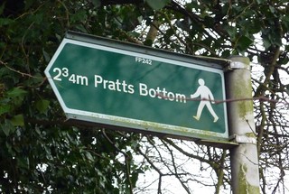
Pratt's Bottom
Time Out Country Walks Freewalks 82 Hayes to Knockholt
Feb-11 • msganching on Flickr
sign walks waymark swc freewalks prattsbottom tocw freewalks82 5439155817


| Length |
16km (10 miles) |
|---|---|
| Toughness |
4/10 |
| Transport |
The stations for this walk are within Zones 5 and 6, so the walk can be done with any travelcard, season ticket or Freedom Pass that covers those zones. Hayes is the terminus of the mid-Kent line that runs from Charing Cross or Cannon Street, calling at London Bridge and Lewisham. Knockholt is served by hourly trains (xx.26) that run between Sevenoaks and Charing Cross, calling at Orpington and London Bridge. Change at Orpington for frequent local trains to Victoria. A return ticket to Knockholt is valid for the outward journey to Hayes. Suggested train : Catch the train nearest to 9.45am from Charing Cross to Hayes. |
| Maps |
OS Explorer 147 + tiny bit of 162; OS Landranger 177 and 187 |
| Walk notes |
Although close to London, this walk in the north-west of Kent is entirely rural in character, traversing fields, woods and valleys in London’s ‘Green Belt’. It passes Charles Darwin’s home, Down House, now an English Heritage property housing a fine exhibition about Darwin’s life and work. The lunchtime pub options are in Downe (a little less than halfway), or in Cudham (a little over halfway). The tea stops are 30 -40 minutes from the end of the walk. |
| Shortening the walk |
If stopping for lunch in Downe, or taking a picnic, you could take the Short cut option from Downe [point 16 in the directions], which passes through a nature reserve associated with Charles Darwin. This bypasses Cudham and cuts about 1km off the total distance. If you plan to visit Down House (which is worth spending a couple of hours at) you could finish the walk at Downe, and later take the 146 bus (hourly, 7 days a week) from Downe to Bromley South for frequent trains to Victoria. The bus leaves from the roundabout at the centre of Downe. |
| Lunch and Tea |
The Blacksmith’s Arms , Cudham Lane South. Cudham, TN14 7QB (01959 572678). Food served noon -3.00pm every day. Located 9.5 km from the start of the walk, this is the suggested lunch stop. The Queens Head , High Street, Downe, BR6 7US (01689 852145). Food served noon - 2.30pm Mon - Fri; noon - 3.30pm Sat & Sun. Located 7 km from the start of the walk, this is a possible early lunch stop, especially for those planning to visit Down House. The George & Dragon , High Street, Downe, BR6 7UT (01689 889030). Food served noon -2.30pm Mon - Fri; noon – 4.00pm Sat & Sun. Possible early lunch stop, located 7 km from the start of the walk. Arthur's Coffee Shop & Restaurant Coolings Nurseries, Rushmore Hill, TN14 7NN (01959 532269) / www.coolings.co.uk) . Food served 9.30am - 4.45pm Mon – Sat; 10am – 4.30pm Sun. Possible tea stop, located 2.5km from the end of the walk. The Rose and Crown Otford Lane, Halstead, TN14 7EA (01959 533120) Possible tea stop - 500 metres off route – located 2km from the end of the walk. |
| Status | Document last updated Monday 25 January 2010 |
| Profile | |
|---|---|
| Help Us! |
After the walk, please leave a comment, it really helps. Thanks! You can also upload photos to the SWC Group on Flickr (upload your photos) and videos to Youtube. This walk's tags are: |
| By Train |
Out (not a train station) Back (not a train station) |
| By Car |
Start BR2 7EN Map Directions Return to the start: Finish TN14 7HR Map Directions Travel to the start: |
| Amazon | |
| Help |
National Rail: 03457 48 49 50 • Traveline (bus times): 0871 200 22 33 (12p/min) • TFL (London) : 0343 222 1234 |
| Version |
Apr-24 Chris L |
| Copyright | © Saturday Walkers Club. All Rights Reserved. No commercial use. No copying. No derivatives. Free with attribution for one time non-commercial use only. www.walkingclub.org.uk/site/license.shtml |


Walk Directions
- Leaving Hayes station, cross to The New Inn pub, turn right, then left up Station Hill and follow it round to the right. In 120m, at a T-junction, cross Warren Road onto Hayes Common, taking the middle of three grass paths (direction 190°). Enter the woods ahead, soon crossing a lane to continue through the wood (direction 150°).
- In 90m, take the left fork, and continue straight ahead on the main path for 650m, ignoring all side paths and cross paths. On passing a small triangular area bounded by logs, with a bench on each side, join a path from the left, and bear right for 180m to emerge from the wood, past a wooden horse barrier, at the junction of Croydon Road and West Common Road.
- Cross the busy Croydon Road with care, and go along West Common Road, forking left after 20m on an unsigned path into a wood. Soon after passing back gardens to the left, keep left at a fork, and continue heading east for 220m, going straight on at a cross path. At a path T-junction, turn left and in 40m turn right on a narrow path that soon leads to a road.
- Cross the road, turn left then in 10m turn right through a gap in the wooden railings on to a path that immediately bears right to run parallel to the road (direction 170°) through a stretch of gorse and heather. This path can get waterlogged after rain. In 120m go up a slight slope, then in 100m join a path from the left and bear right. In 160m, at a clearing, turn left, then right (direction 170°). Go straight on at a cross path to emerge from the wood past a wooden barrier on to Keston village green.
- Head across the green to the Greyhound pub, passing it on your left, and turn left at the road junction, leaving the Fox pub on your right. In 40m turn left into Lakes Road, following a London Loop sign. You will stay on the Loop for the next 2.4km, and can use the LL signs for navigation in cases of doubt.
- At the end of the road go straight ahead on a tarmac path into woods (Ravensbourne Meadows). Where a school fence on the right ends, cross a stream, ignore a path to the right and continue straight on, crossing another small stream. The path gradually bends right, and in 200m a lake can be seen through trees on the left, before the path ends at Fishponds Road.
- Cross the road and go straight ahead along the edge of a second lake, ignoring a higher parallel path. These lakes, and a third one ahead, are the Keston Ponds, a popular fishing spot. At the end of the lake, go up steps straight ahead to turn left alongside the next lake, and follow the path round to the right, staying beside the lake.
- At the far side, you pass a shallow, circular, pebble-filled pool which is a spring, known as Caesar’s Well, that feeds the lakes and is the source of the River Ravensbourne. Go up steps to cross a car park, passing to the left of the island of trees, towards footpath signs on a post ahead. Go past a wooden barrier and take the path ahead, initially in a cutting, for 300m. At a T-junction turn left towards the adjacent road, following a sign marked ‘Wilberforce Oak’.
- Cross the road and go up the path opposite, signposted to Downe, with a barbed wire fence to the left, behind which are the extensive grounds and buildings of Holwood House. In 500m, at the crest of the hill, is the Wilberforce Oak. Continue onwards, crossing a drive, to descend fairly steeply for 400m to reach the junction of Downe Road and Shire Lane. Just before reaching the road you leave the London Loop and ignore a metal kissing gate on the left.
- Go straight on along Downe Road for 150m, and just past the sign for Holwood Farm on the left, cross a stile on the right, and in 30m a second stile into a field. Follow the right-hand side of this field and the next two fields, where horses are usually grazing. At the end of the third field, bear left towards a yellow arrow on a post, and follow the path (direction 100°) through trees up to a kissing gate to reach another field. Follow the clear path diagonally (direction 180°) up this field to enter a wood. Then, in 40m, at a 3-way footpath sign, take the left fork to go up a small slope and past a redundant stile. In 50m cross a stile beside a large oak to follow a path straight across a field. In 300m this becomes an enclosed path that soon leads out to a road (Rookery Lane), where you enter the village of Downe.
- Turn right into High Street, Downe and in 250m reach the Queen’s Head pub on the left, with the George and Dragon just across the roundabout ahead. Either of these pubs can be used for an early lunch stop, but the recommended lunch pub for this walk is about 2km further on at Cudham.
- Here you have a choice. If stopping for lunch at Downe, you could follow the short cut option afterwards, bypassing Cudham and shortening the walk by about 1km.
- Option 1) The Main Route
- At the roundabout, with a tree in the centre, bear right up Luxted Road. In 100m turn left, between gardens, following a footpath sign to Cudham. In 80m continue along the left-hand side of a field, follow it round to the right, then in 30m turn left into another field. Turn right to go along the right-hand side of the field for 120m, and pass through into the next field. [To visit Down House, now take the right-hand path for 100m and turn right through a metal kissing gate to cross the road.]
- If not visiting Down House, take the left-hand path towards the far left-hand corner of the field and go through a kissing gate. Go straight ahead and in 20m turn right at a footpath arrow on a wooden post. In 60m pass Downe Court Farmhouse on the left, then cross its driveway and continue for 30m to another footpath marker post where you turn left along the left-hand edge of a field. In 80m follow the field corner round to the right and in 120m, at a cross path, turn left along the right-hand side of a field (direction 100°). In 250m enter a wood and follow the twisting path downhill to descend some steps and turn right along a road.
- In 50m, just past a white coal post, turn right across a stile (marked with a ‘permissive path’ sign) into a field, and turn half-left across it (direction 120°). In 200m, cross a stile and turn right up an enclosed bridleway that runs alongside a road to the left. In 600m go up steps, turn left onto a road, then in 20m turn right uphill to reach a crossroads. Cross the road and go up a drive into the churchyard of St Peter and St Paul Church, Cudham. Follow a tarmac footpath to the right of the church and in 100m exit the churchyard onto a large playing field. To reach The Blacksmith’s Arms (the recommended lunch stop), turn right along a tarmac footpath and in 180m, after passing a brick sports pavilion, turn right through a gap in the hedge into the pub car park.
- On leaving the pub, go back through the car park to the playing field and turn left to go past the sports pavilion, then turn half-right to go diagonally across the playing field (direction 120°) to a kissing gate near the far corner. [If not stopping at the pub, head directly from the churchyard towards this corner]. Pass through the gate, turn half-right across a drive and go through another kissing gate into a field. Follow a path half-right (direction 40°) across this field to go through a kissing gate and continue in the same direction across the next field. At the far side, bear left to take a path beside a narrow band of trees for 150m and turn right onto a lane.
- Option 2) Shortcut from Downe
- Turn left out of the Queen’s Head to pass the church entrance and then cross the road [or turn right out of the George and Dragon]. Go along Cudham Road (direction 130°) for 220m and, soon after passing Christmas Tree Farm, ignore a footpath on the right to Luxted and Biggin Hill, but fork right 20m beyond this on to a signed footpath to Cudham that runs alongside the road for 600m, crossing a farm track halfway, before it returns to the road. Here you turn right and in 20m turn left, past Hangrove Cottage, on a car-wide track signposted to Cudham. In 30m pass round a wooden gate marked ‘Downe Bank’ and in 80m, at the entrance gate to Gorringes Farm, turn right, following a footpath sign to Cudham Lane North, down a stepped path into Hangrove Wood. Continue down wooden steps and through a gate into Downe Bank Nature Reserve, a Site of Special Scientific Interest. This is where Charles Darwin conducted many of his studies on the relationship between plants and animals. A little further down, pass Orchis Bank (a possible picnic spot) to the right of the path and then continue up the far side of the valley to exit the reserve. Continue on the enclosed path fairly steeply up through a wood, then pass between wooden posts and turn left on a wide track that soon becomes a tarmac lane that continues for 150m to reach a road. Turn left on the road with care (there is no footpath), and in 90m turn right through a gap in the hedge on a signed footpath to Pratts Bottom. In 50m cross a gravel drive and a stile to continue straight on along the right-hand edge of a field. At the far end, turn right (direction 170°) across an open field, then cross a stile and turn left along a lane.
- Both routes continue. Follow the lane for 400m to Mace Farm. Just before reaching cottages on the left, turn right over a stile into a narrow field. At the far end, cross a stile and keep to the right-hand side of the next field as you descend to cross another stile. Continue steeply downhill (direction 100°) to cross a stile into a wood, where the path turns right. In 20m, ignore a wooden gate ahead, and follow the path to the left as it climbs up through the wood to its edge. Cross a stile into a field and head for the right-hand end of a line of trees (direction 120°). Continue straight on alongside the trees, which mark a former field boundary that presently turns left and leads to a stile on the far side of the field. Cross the stile and turn left to follow a path through a narrow belt of trees. In 200m, at a path junction, turn right onto a bridleway that runs though a belt of trees to emerge past a metal barrier onto a lane.
- Turn left on the lane, passing a fieldgate marked Norsted Manor Farm, and follow the lane (Washneys Lane) for 700m, ignoring a footpath to the right at the first bend, and one to the left at the second bend. At a three-way lane junction, turn right onto Perry Lane and in 200m, where the lane bends right, turn left over a stile signposted to Pratts Bottom. Follow a narrow enclosed path for 120m to turn right across a stile and go down into a wood. In 180m, at the bottom of the wood, cross a stile and go up the right-hand side of a field. At the top, cross a stile and turn left to follow a path down between a wood on the right and a field on the left. In 250m, go through a kissing gate onto a lane.
- Turn right up the lane for 70m to reach Rushmore Hill and cross the road. [For an early tea stop with a minimal detour, turn right for 50m to Coolings Garden Centre, where the Arthurs coffee shop is open until 4.45pm Monday-Saturday and until 4.30pm on Sunday.] If not stopping for tea, turn down the drive to Finstock House, following a public footpath sign. In 60m, cross a stile and follow an enclosed path. In 300m go over a stile and straight on, then in 250m, enter a former golf course beside tee 3 and tee 6. Bear right in front of the tees and keep a wood just to the left as the path bends left uphill and continues alongside wooden palings and turns right, then left. At a green wooden fence, turn left over a stile to cross a field and go through a gate to a road.
- At this point you can detour to Halstead for tea. Cross the road and turn right for 15m, then turn left through a kissing gate to go diagonally across a field. In 150m go through a kissing gate and go along the left-hand side of a recreation ground. In 140m, pass through a car park and turn right along a road for 150m to reach The Cock Inn which serves teas and coffees. Afterwards retrace your steps.
- To continue the main route, turn left along the road and in 200m, with the church of St Margaret’s, Halstead, 100m ahead, turn right onto a marked footpath that runs (direction 30°) along the left-hand side of a field. Then follow the path into the next field, keeping to its right-hand edge, and then cross a stile onto a golf course.
- Go forward, around the back of the green ahead, and follow the footpath marker posts that take the path along a line of trees and hedges between fairways to the left and right (direction 30°). In 600m pass a driving range to the left and then a car park. Where the track turns sharp left next to a large metal shed, go straight on for 40m to bear left on a mown grass path and follow it gradually downhill as it slowly bends right towards a gate at the bottom of the hill. Go through the gate and turn left to reach the driveway to Knockholt Station in 50m.