Henley to Pangbourne walk
A lovely country ramble, starts and finishes by the Thames, via forests and country pubs.
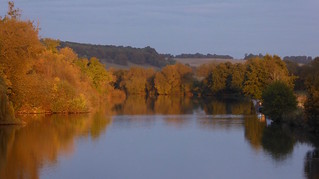
Sunset on the Thames, Pangbourne
Henley to Pangbourne walk
Oct-16 • Saturdaywalker on Flickr
swcwalks book1 walk51 walkicon 30497619916
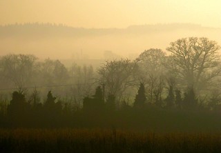
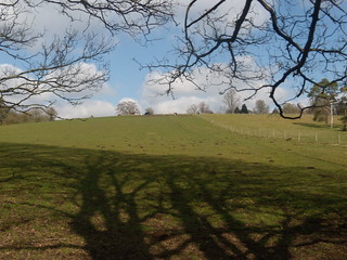
Book 1, Walk 51, Henley to Pangbourne 4
book1 swcwalks walk51 tocw151 346524044

Book 1, Walk 51, Henley to Pangbourne 1
book1 swcwalks walk51 tocw151 346524039

Book 1, Walk 51, Henley to Pangbourne 2
book1 swcwalks walk51 tocw151 346524041
River Thames, beech woods, pubs & alpacas
| Length | 19.2km (11.9 miles), 5 hours 40 minutes. For the whole outing, including trains, sights and meals, allow at least 9 hours 30 minutes. |
|---|---|
| Toughness | 6 out of 10. |
| OS Maps | Explorer 171 or Landranger 175. Henley, map reference SU 764 823, is in Oxfordshire, 10km north-east of Reading. Pangbourne, map reference SU 633 766, is in Berkshire, 8km west along the River Thames from Reading. |
| Features |
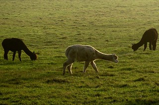
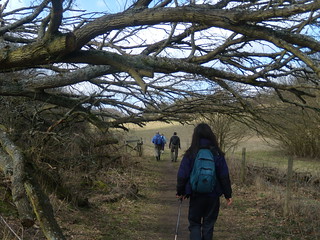
A lovely walk, starting and finishing by the Thames, and passing through many woods en route. This walk used to be our pub crawl walk, as you used to pass many pubs along the way. Alas, some of these pubs have closed in recent years, or they have stopped serving food at lunchtime. This is quite a long walk with some road and lane walking, hence it is a bit long for mid-winter unless you start early. The walk starts beside the Thames in Henley, goes down one of Henley's most ancient streets, out into a broad valley, to the church and first pub at Rotherfield Greys. It then goes to the church at Rotherfield Peppard, and thereafter it is fields, beech woods and small villages. As at the latest walk update, there remain at least two pubs located close to mid-walk for your lunch stop, plus others at walk-end. The walk also includes an alpaca farm just outside Whitchurch where you can watch hundreds of alpacas grazing in the fields, a true highlight towards the end of the walk. On the final leg the walk then carries on to the Whitchurch parish church beside the Thames, to the toll bridge over the Thames, and finally into Pangbourne for a last refreshment stop. |
| Walk Options | The walk can be shortened to 8 miles by catching a bus just outside what used to be the Chaiyaphum Thai restaurant, at Cane End (now closed down for housing redevelopment). However, by taking this option you will miss the highlight of the alpacas towards the end of the walk. From just outside the restaurant, buses X39/X40 run into Reading about twice an hour Monday to Saturday, hourly on Sunday, taking about 25 minutes for the journey. For more bus information, phone 0871 200 2233. Alternatively, you could order a taxi from any of the pubs en route. As noted below in the lunch notes, you can also reverse the closing leg of TO Book 1 - Shiplake to Henley, to bring into play the Maltsters Arms for lunch. This adds about a mile to your walk. |
| History |
Henley with its 300 listed buildings is said to be the oldest settlement in Oxfordshire. St Nicholas' Church in Rotherfield Greys (if you should be lucky enough to find the door unlocked) contains the ornate tomb of Robert Knollys, counsellor to Elizabeth I and friend of Mary Queen of Scots. The building of All Saints Church, Rotherfield Peppard, began in the twelfth century. It has early twentieth-century stained-glass windows designed by Meredith Williams, son of a rector of the parish. At the start of the twentieth century, Mirabel Grey, another local artist, made the Last Supper picture behind the altar and the other panels of inlaid wood. St Mary's Church, Whitchurch, dates from the twelfth century. St Birynius is said to have landed at the ferry crossing at Whitchurch and, on seeing how fine the place was, decided to build a church. An Act of Parliament in 1792 allowed the building of Whitchurch Toll Bridge to replace the ferry. The ten proprietors were given the right to charge tolls, for instance one halfpenny for every sheep and lamb. The present iron bridge built in 1902 replaces two previous wooden toll bridges. The earliest mention of Pangbourne is in a Saxon charter of 844 as Paegingaburnam (meaning 'streams of sons of Paega'). In 1919, DH Lawrence stayed in Pangbourne, commenting: 'Pleasant house - Hate Pangbourne - Nothing happens.' Kenneth Grahame, author of The Wind in the Willows, lived in Church Cottage. |
| Travel |
Take the train nearest to 10am from Paddington Station to Henley-on-Thames, changing at Twyford. Journey time 65 minutes. Trains back from Pangbourne to Paddington are every half hour (hourly on Sundays). Journey time 1 hour 15 minutes, or just under an hour if you change at Reading for a faster service. Train ticket : Buy a return to Pangbourne, and, a single from Twyford to Henley (£2.40 contactless, £4.70 paper ticket). The branch line from Twyford to Henley accepts contactless (but not Oyster), there is card reader at the platform entrance to tap in with. In the past, a Pangbourne return ticket has been accepted on the Henley branch line (with the discretion of the guard), but technically you do need a seperate ticket. Elizabeth Line : if you are a senior walker who holds a Freedom Pass you can travel free of charge on these TFL trains (blue livery) as far as Twyford or Reading, leaving you to purchase singles from Twyford to Henley and Pangbourne to Reading (i.e. on the way back from Pangbourne, change at Reading for a slower Elizabeth line train). However, if seniors travel on a Great Western train (green livery) they should buy a day return from the Zone 6 boundary to to Pangbourne plus the single from Twyford to Henley. |
| Lunch |
This walk when first written was advertised as a pub crawl walk, due to the number of watering holes en route. Alas, most have closed down in recent years, with Covid-19 accounting for the latest closures. As of summer 2023, you pass by, in order that you reach them. If you intend to do the short, 8 mile version of the walk and start late, the well-regarded Maltster's Arms (tel 01491 629974) in Rotherfield Greys, which is the first pub reached on this walk, after just 4.3 km, is a good option (and many consider to be by far the best). Refurbished in 2022 and reopened under new management, this pub's kitchen is closed on Monday and Tuesday, but open for food on Wednesday to Saturday from 12 nooon until 9 pm and on Sunday from 12 noon until 5 pm. Booking ahead is recommended and at weekends essential to avoid disappointment. For those doing the full walk, try reversing the closing leg of Book 1, Walk 9 - Shiplake to Henley, as far as Rotherfield Greys, going via Lambridge Wood and Greys Court: the Maltsters Arms then comes into play as your lunch option. Granted, you then have a long afternoon, but SWC walkers who like the Maltsters believe it worth it. The Red Lion (tel 01491 756 561) in Peppard Common, 7.6 km into the walk, reopened 2022 after lengthy closure and back "roaring again". Closed Mondays and other daytimes until Friday, and serving lunch Friday, Saturday and Sunday, from 12 noon until evening. The Unicorn (tel 01491 628 674) at Kingwood, 8.6 km into the walk, open for lunch Wednesday to Sunday from 12 noon until 2.30 pm (to 4 pm on Sunday).The pub serves a good value sandwich menu, Monday to Saturday plus a full menu, and on Sunday classic roasts plus other main dishes. The Reformation at Kidmore End, 10.4 km into the walk, has permanently CLOSED having recently (2022) lost its battle to be classified a community asset. The building will become a vets practice and surgery, with new housing in the grounds. |
| Tea |
The suggested tea place is The Swan, a riverside pub opposite the station [Feb-24 - Temporally closed due to flooding]. In the nearby town centre, you could try the George Hotel (tel 0118 9842237), The Elephant Hotel (tel 0118 9842244), the Cross Keys pub (tel 0118 9843268), Costa Coffee or Cozze (a cafe/restaurant). Opposite the George Inn is a Co-op Convenience store. |
| Updates | Walk instructions were fully checked and the website version updated in November 2016 with further updates September 2018. Pubs and travel updated Feb-24. |
| Book |
This walk was originally published in Time Out Country Walks near London volume 1. We now recommend using this online version as the book is dated. The book contained 53 walks, 1 for every week of the year and 1 to spare. Here is our suggested schedule |
|---|---|
| Profile | |
| Help Us! |
After the walk, please leave a comment, it really helps. Thanks! You can also upload photos to the SWC Group on Flickr (upload your photos) and videos to Youtube. This walk's tags are: |
| By Train |
Out (not a train station) Back (not a train station) |
| By Car |
Start RG9 1AY Map Directions Return to the start: Finish RG8 7DY Map Directions Travel to the start: |
| Amazon | |
| Help |
National Rail: 03457 48 49 50 • Traveline (bus times): 0871 200 22 33 (12p/min) • TFL (London) : 0343 222 1234 |
| Version |
Apr-24 Marcus |
| Copyright | © Saturday Walkers Club. All Rights Reserved. No commercial use. No copying. No derivatives. Free with attribution for one time non-commercial use only. www.walkingclub.org.uk/site/license.shtml |


Walk Directions
- Coming out of Henley Railway Station , turn right and walk 50 metres to the main road. Here, opposite the Imperial Hotel, turn right onto the main road. In 120 metres, bear left and you are walking along the Thames with the water on your right-hand side.
- In 120 metres, turn left up Friday Street, soon passing the Anchor Inn on your left hand side. Go straight on, ignoring all turn-offs. In 200 metres, cross Reading Road and turn right then almost immediately left to continue in the same direction along Greys Road.
- In 240 metres, fork right onto Deanfield Avenue. In a further 15 metres you fork left onto a car lane, signposted on the right-hand side as a public footpath (the sign could be obscured by bushes at certain times of the year), your direction 230°. Go straight on, ignoring ways off.
- In 350 metres the path ends and you come out at a tarmac road. Go along the road in the same general direction as before, now 250°. In 160 metres turn right into the third residential street on the right, Tilebarn Close.
- In 100 metres, turn left due west on a footpath (the path on the right-hand side of two paths on the left which is sign-marked Rotherfield Grey) and goes between fences (ignoring the wider footpath to the far left). [2]
- In 50 metres, go through a defunct rusted metal kissing gate; soon you pass tennis courts on your right-hand side. Ignore ways off, your path now between fences. In 480 metres cross over a bridleway and pass to the left of a redundant stile in a field boundary and keep straight on, your direction 320°. Soon you are going through a delightful valley.
- In 600 metres, go over a stile into a small copse. Continue on, slightly to your right, following a couple of faded white arrows on trees, your direction 295° (ignoring a path to the right going uphill on the side of the field). In 85 metres go over a stile to continue ahead in the same direction on a potentially muddy track. In a further 200 metres, you come to a path junction and carry straight on through a field, your direction 265°.
- After 375 metres, at a footpath post with yellow arrows fork right to go over a stile 20 metres to the right, following a yellow arrow, your direction 280° (ignoring the field gate and path to the left visible before you cross the stile). In 250 metres, go over a stile to the left of a field gate and continue straight on.
- [!]In 45 metres, go left over a stile to follow its yellow arrow’s direction westwards, to the right, with a field hedge on your right-hand side. In 70 metres, fork left uphill, your direction 240° initially, with a field fence on your left-hand side. When you reach the top of the rise it is worth looking back for a great view. Continue ahead in the same direction passing by a redundant gate on the left.
- In 510 metres, bear left to come out through a wooden kissing gate onto a tarmac road, where you cross the road and turn right. In 20 metres, you pass the lychgate of St. Nicholas’ Church, Rotherfield Greys.
- [3] In a further 25 metres, with the Maltster’s Arms pub ahead of you, to the right - and if not stopping for an early lunch here - turn left on a signposted public footpath, your direction 180°, keeping to the edge of the churchyard on your left-hand side. In 70 metres, go through a swing gate and veer right, your direction 220°. In 20 metres, go through another swing gate to continue in the same direction across a field. In 220 metres, go through a metal swing gate and in a further 10 metres go through a metal gate to then go half right across another field.
- In 140 metres, go through a metal swing gate and turn left on a wide path between small trees, your direction 185°.
- In a further 150 metres, go through a wooden swing gate (with a metal field gate to its left) and turn right on a car wide track, your direction 280°.
- In 80 metres, by a public bridleway sign, go left through a metal swing gate (a metal field gate to its right), your direction 160°, on a potentially muddy path that winds its way along the fringe of the wood and ignore ways off.
- [!] In 200 metres at a footpath crossing, turn right to go through the metal kissing gate to the right on a path due west with trees on either side, ignoring all ways off. After 600 metres go straight across a track to pass through a metal kissing gate and carry onwards between the fences of Rectory Farm.
- In 200 metres, go over a stile onto an earth car road where you turn right, your direction 300°. In 130 metres, you arrive at a tarmac lane with the fine All Saint’s Church, Rotherfield Peppard just ahead where you turn left and then bear left at the junction of roads in front of the church to carry on along the road, Church Lane, ignoring ways off.
- In 350 metres, with School House on your right and Slaters Farm on your left, fork right, still on a tarmac road, your direction 330°. [4] Head towards The Red Lion pub , Peppard Common, a lunch option, visible 240 metres ahead and reached after crossing the main road.
- At the pub, turn left on the minor tarmac road, your direction 240°. Carry along this road for 1 kilometre (ignoring all ways off) when you will arrive at the Unicorn pub on the right-hand side, another lunch stop option.
- At the Unicorn pub (or if leaving the pub) go straight ahead to cross a minor road. In a further 35 metres, cross the main road to carry on down Wyfold Lane. Continue ahead, ignoring all ways off.
- In 300 metres, turn left through the metal kissing gate to go due south on a signposted footpath, with a field hedge on your right-hand side. In 200 metres, go through a gap with a metal field gate on the right. Continue along the enclosed path.
- In 150 metres, go over a stile and turn sharp right, your direction 310° with the field hedge on your right-hand side, follow the path as it veers to the left-hand corner of the field.
- In 130 metres go through (or past) a metal gate to enter a beech wood, New Copse (so marked on the OS Map). 5 metres after the gate, fork left (ignoring the path straight ahead). [!]In a further 10 metres, take the less distinct right fork, due west. In 20 metres pass by a footpath post on the right with a yellow arrow and an "Access on foot only" sign to keep straight on, ignoring ways off, your path marked intermittently by white arrows on trees. At one point the track appears to fork, take the right fork straight ahead (following the arrow on a tree).
- [!] In 850 metres, there is a T-junction marked on a tree to the left, just ahead of a multiple footpath junction, with part of a wooden fence directly in front of you and four possible ways onwards (You can see a field gate and the edge of the wood visible 50 metres away to the right). At this intersection go left, your direction 165°, following the arrow on the tree in front of you.
- In 150 metres, veer left with the path, heading due south and in a further 150 metres at an obvious cross-roads in a large clearing keep straight on, your direction 170°. In a further 370 metres, having ignored all ways off, you pass through some wooden barriers and turn right to pass through some further barriers in 15 meters to emerge onto a car lane lined with houses where you go left, your direction 110°.
- In 140 metres, you pass the interesting cogwheel of a well on your left-hand side and in 15 metres, you come to the main road where you turn right, your direction 250°. [5] In 50 metres, you arrive at what was the Reformation pub in Kidmore End (permanenty CLOSED and now converted to another use).
- Continue past the pub building along the main road. In 270 metres you pass Wyfold Road on the right and in another 200 metres (just before the road starts to curve to the right) turn right onto a path which is marked with a footpath post. In 10 metres pass through a wooden barrier to the left of a wire fence to follow a white arrow marked on a tree by forking left, your direction 270°. This is Withy Copse (so marked on the OS Map).
- Continue along this footpath (which can be faint and overgrown at times but marked by occasional white arrows) as it winds its way through the trees, ignoring all ways off. In 650 metres at a junction of paths, fork left to effectively continue straight ahead and in a further 50 metres, you reach a fence and metal fieldgate with the garden of a house to the right.
- Veer left to go through a metal gate with a yellow arrow. Continue half left for 50 metres through a small field and go through another metal gate with a yellow arrow. Follow the arrow direction half-left through the next field and exit at the top left-hand corner through a gate onto a road where you turn left.
- In 60 metres take the signposted footpath through a kissing gate to your right, your direction 220°. Keep the field hedge on your left-hand side at this point (a timber-framed cottage is sometimes visible ahead of you to your right).
- [!]In 165 metres (about 40 metres before reaching the field corner), take a stile to your left in the fence and turn right to continue on an entrance driveway (ignoring an earlier footpath signpost on the left about half way along this field edge). In 35 metres, turn left on the A4074, your direction 130°.
- In 105 metres, you pass what used to be The Chaiyaphum Thai restaurant, Cane End on your left (now a small housing estate). The bus stop for the X39/X40 route to Reading is in front of this estate.
- 40 metres past the estate, where a lane comes in from the left, cross the main road carefully to go onto an earth track opposite, leading to a metal swing gate by a metal field gate. Ignore the track straight ahead and follow the blue and yellow arrow marked bridleway half left, your direction 170°.
- In 50 metres go through a metal swing gate and then half right, your direction 205°. In 30 metres, go through another metal swing gate and in a further 5 metres another. Keep straight on along the right-hand side of a field.
- After 120 metres, at the corner of the field, continue ahead with trees on the left and a hedge on the right. In another 80 metres emerge from the trees into a field and follow a path to the right. In a further 70 metres, you enter a wood, your direction 240°. Keep on the main car-wide track as it curves left and then right. In 100 metres, at a path junction, keep straight on along a track, with the edge of the wood to your right and a field on your left, your direction 295°.
- In 100 metres, at a crosspaths, continue straight ahead on into the wood, following white arrows on the trees. In 210 metres, follow the path to the left, your direction 250°.
- In 135 metres, at a junction, go straight on along a tarmac road (ignoring tracks to the right and left), your direction 240°. In 10 metres, you pass Crossways Cottage on your left-hand side. In a further 160 metres, by concrete bollards on your left-hand side[!], take the signposted bridleway to your right into the wood, your direction 280°, on a wide muddy track (part of the Hardwick Estate). [!] In 25 metres, pass to the left of a gate and veer left onto a narrower path going deeper into the woods (ignoring a wide track going off to the right.) Ignore all ways off through the woods.
- In 150 metres, turn left, on a track going gently downhill following intermittent white arrows on the trees, your direction initially 240°. Ignore ways off. In 150 metres, your route is gently uphill. In 120 metres, near the top, follow a white arrow on a tree straight on (ignoring ways off) your path slightly narrower now.
- In 400 metres after winding your way through the wood on the track, you come to a tarmac road where you turn left, your direction 120°. In 100 metres you arrive at a house on the left called The King Charles’ Head (formerly a pub). [6]
- Opposite this house, you go right on a footpath through a wooden kissing gate, signposted Path Hill, your direction 230°. In 100 metres, having passed a redundant stile on the right, pass through a kissing gate to the left of a wooden gate to follow the edge of the wood on your left-hand side, your direction 250°.
- In 125 metres, go through a metal kissing gate. In 65 metres, your way merges with a driveway and you continue between fences past a flint cottage on your left-hand side. In a further 145 metres, cross a tarmac lane to go straight on along a very wide earth avenue.
- In 150 metres, turn left on a car-wide earth road, your direction 190°. In 50 metres, where there is a yellow arrow on a corner post on your left-hand side (past a large wooden shed on the right and ignoring an earlier turning to the right between sheds), you go right, your direction 290°. Then, in 25 metres, go through a metal kissing gate to the right of a metal field gate and veer slightly to the left across a small field towards a gap in a fence in about 20 metres leading into an adjacent larger field. Continue half-left downhill across this next field, your direction 250°.
- In 80 metres, you go through a metal kissing gate straight into the wood. In a further 110 metres, you exit the wood through a metal swing gate to continue downhill across a field due west.
- In 80 metres, go through a metal kissing gate and turn left uphill, your direction 245°, with the edge of the wood fairly near you on your left-hand side. In a further 120 metres at the top of the hill, go through a gap in the boundary hedge (visible from the top of the hill) to go straight on.
- In 75 metres, go through a usually open fieldgate onto a tarmac lane with farm buildings opposite. [7] Cross the lane and carry straight on along a tarmac lane, signposted footpath, your direction 220°. In 200 metres, you pass the entrance on your left-hand side to a house with turrets.
- In 45 metres, you go through a wood barricade slightly to your right (level with the house’s garden gate) to go downhill, ignoring a wider path downhill to the left.
- In 230 metres, you come to a tarmac road (approach with care as there can be fast moving cars on it) which you cross to continue straight on, past a broken stile through a usually open metal field gate. Continue onwards with a field hedge on your left-hand side.
- In 60 metres, you go through a metal kissing gate. In 25 metres, by a post with yellow arrows, turn left downhill, your direction 165°, with a field hedge on your left-hand side. In 150 metres, you come to a tarmac road where you go right. Continue along the road where through occasional breaks in the hedge on your left you can see a large number of grazing alpacas.
- Now walk along the path through the grassy margin on the left-hand side of the road, and in 500 metres you come to the Bozedown Alpaca Farm on the right. Continue on and at the end of the farm buildings, go right off the road at a bench onto a signposted path parallel and above it. In 300 metres, the path rejoins the road for the second time (having previously dipped down very close to it to cross a driveway). 20 metres after the path rejoins the road for good, turn left at a signposted footpath beside a wooden field gate onto a wide track, your direction 170°.
- In 40 metres on your left you come to the entrance to the Whitchurh Thyme Maze, apparently located on some ley lines and worth a short detour. In a further 50 metres carry on straight ahead through some wooden bollards across the track. In 190 metres, turn right on the tarmac driveway of a primary school, your direction 235°. In 50 metres, bear right on a lane and, in a further 440 metres, you come to the main road, with the Greyhound pub, Whitchurch, on your right-hand side. You turn left, due south.
- In 35 metres, take the footpath right to the church, signed Thames Path, on the tarmac driveway of Walliscote House. In 15 metres you fork left, your direction 225°.
- In 65 metres (just before the lynchgate to the Parish Church of Whitchurch-on-Thames (which is worth visiting)), you veer left on the faint path through the churchyard (or turn right out of the church). Leave the churchyard through a gap to go down a narrow path between brick walls. In 30 metres, turn left on a gravel road by a mill house, with the Thames on your right-hand side.
- In 65 metres, you come back to the main road and turn right to cross Whitchurch Toll Bridge over the Thames.
- If you do not wish to go into Pangbourne for tea, you can take the signposted path to the station on your right 40 metres after the bridge.
- Otherwise continue on the road. 250 metres after crossing the toll bridge, go under the railway bridge. In 75 metres, with the George Hotel on your right-hand side, you come to the main road T-junction. Turn left along Reading Road and in 25 metres you arrive at Café St. Louis on your left-hand side, one of the suggested tea places. Coming out of the café, turn right, cross over the mini-roundabout and keep ahead, in 85 metres coming to another mini-roundabout at the junction with the A329. The Elephant Hotel – another possible tea/ late meal stop – is opposite. If you turn left, you come to the Cross Keys pub on your left-hand side in 60 metres.
- But to get to the railway station, at the road junction opposite the Elephant, turn right, to pass the Parish Council Offices and Village Hall on your left-hand side (with a useful WC block in the front of the car park).
- In a further 100 metres, just before the railway bridge, turn left up the lane to Pangbourne Railway Station. Pass under the tunnel to reach platform 2 for trains to London. (Alternatively, you can walk under the railway bridge and take the access road on your left-hand side, which leads to the station. Platform 2 is now on your nearside).