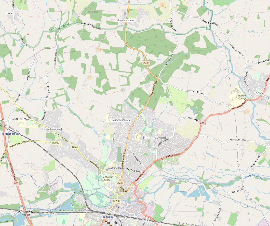
Hildenborough to Hadlow or Tonbridge walk
Gentle walk through the Kentish Weald to one of the tallest follies in Britain.


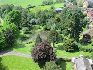
CIMG1126
Looking down
May-14 • Sean O'Neill
swcwalk219, swcwalk220, swcwalks, walkicon 6036275969027237250 P
CIMG1126
Looking down
May-14 • Sean O'Neill
swcwalk219, swcwalk220, swcwalks, walkicon 6036270079003108578 P


CIMG2749
Oriental Style Garden, Broadview Gardens
Jul-14 • Sean O'Neill
swcwalk219, swcwalk220, swcwalks, walkicon 6036276459083221698 P

CIMG2749
Oriental Style Garden, Broadview Gardens
Jul-14 • Sean O'Neill
swcwalk219, swcwalk220, swcwalks, walkicon 6036271118432992642 P

Hadlow Tower
Tonbridge Circular walk
Apr-16 • Saturdaywalker on Flickr
swcwalk220 swcwalks swcwalk219 walkicon 26079611944
| Length |
Main Walk, to Hadlow: 13¼ km (8.2 miles). Two hours 55 minutes walking time. For the whole excursion including trains, sights and meals, allow at least 7½ hours. Extended Walk, to Tonbridge: 20¼ km (12.6 miles). Four hours 30 minutes walking time. |
|---|---|
| OS Maps |
Explorers 147 & 148 (plus 136 for the Extended Walk). Hildenborough, map reference TQ557485, is in Kent, 4 km NW of Tonbridge. |
| Toughness |
2 out of 10 (3 for the Extended Walk). |
| Features |
Despite its rural location there are no useful footpaths near Hildenbrough station so there is a fair amount of roadside walking before you escape into typical Wealden countryside of fields, meadows and the occasional wood. At Shipbourne (pronounced Shibbun) you join the Greensand Way for a short section to the hamlet of Dunk's Green, then head south-east along the valley of the River Bourne to Hadlow. On this last stretch you find yourself heading towards one of the more peculiar sights you are likely to encounter on a Home Counties walk: a multi-tiered Gothic folly, taller than Nelson's Column. Hadlow Tower was built in 1838 by William Barton May as an embellishment to his equally eccentric father's extravagant house in Strawberry Hill Gothic style: “the most singular looking thing I ever saw” according to William Cobbett. Much of Hadlow Castle was demolished in 1951 but fortunately the Tower was saved; after a local campaign it has now been beautifully restored. The Tower used to be open to visitors on summer Thursdays and the walk was designed to be short enough for walkers to reach Hadlow in time to visit it. It is now a luxury holiday rental property and although the owner is obliged to hold some open days as a condition of its restoration, visits have to be booked at least one week in advance. The walk route also passes Hadlow's other attraction, Broadview Gardens (free entry). This is a collection of small landscaped gardens designed by successive generations of horticultural students at Hadlow College. Parts of the route overlap the Leigh to Sevenoaks walk (1–21) and (in reverse) the Yalding to Sevenoaks walk (#41). |
| Walk Options |
For a longer walk you can continue to Tonbridge (pronounced Tunbridge: see Walk Notes). From Hadlow this Extended Walk heads south along a quiet lane, continues across large farm fields to the River Medway and finishes with a long but easy stretch alongside the river. The route to the River Medway was changed in 2019. The old route was slightly problematic, so when the Hadlow to Tonbridge section of another walk was dropped it was transferred to this walk. For an even longer extension you could tack on a loop to the west of Tonbridge, either around the large Racecourse Sportsground (an extra 2 km) or through Haysden Country Park (4 to 7 km). The directions for these extra variations can be found in the Tonbridge Circular via Tudeley walk (#220). |
| Transport |
There is a half-hourly service (hourly on Sundays) from Charing Cross to Hildenborough, the station between Sevenoaks and Tonbridge, taking 42 minutes. Tonbridge has around four fast trains an hour to London. Buy a return to Tonbridge. There is no station in Hadlow, but at the end of the Main Walk Arriva 7 runs half-hourly along the A26 to Tonbridge (but no service after 5.30pm on Sun & BH). Earlier in the walk there is an infrequent service (Autocar 222; Mon–Fri) through Dunk's Green and Shipbourne to Tonbridge. The Main Walk is not convenient for car drivers as you would have to return via Tonbridge, but for reference the station car park at Hildenborough costs £7.40 Mon–Fri, £4.50 Sat, £3.50 Sun & BH (2023). |
| Suggested Train |
Take the train nearest to 10:00 from Charing Cross to Hildenborough. |
| Train Times |
|
| Timetables |
|
| River Levels |
|
| Lunch |
There are two possible lunch pubs on the route to Hadlow. Halfway through the Main Walk the Chaser Inn (01732-810360) in Shipbourne has a pleasant beer garden next to the churchyard and serves food all afternoon. Half an hour further on you come to the smaller and quieter Kentish Rifleman (01732-810727), a charming old pub in the hamlet of Dunk's Green. It serves homemade food up to 2pm (later at weekends) and also has an attractive back garden. |
| Tea |
This walk's original tea place was the Broadview Gardens Tearoom, but this closed in early 2023. The only pub near the end of the walk is the Two Brewers, but this is “temporarily closed”. Unless it reopens, the only remaining place in Hadlow is a small coffee shop in Weathered and Worn (07715-680862; open to 5pm Tue–Sat, closed Sun & Mon), on the High Street between the Gardens and the Tower. There are plenty of pubs, restaurants, cafés and coffee shops in Tonbridge. The Extended Walk route comes out onto the High Street opposite The Humphrey Bean (01732-773850), a JD Wetherspoon's pub in the old Post Office building with a beer garden overlooking the river, and continues past Sixty Five MM Coffee (07878-897871) in River Walk. If you detour across Big Bridge (or alight from the Hadlow bus at the Tonbridge Castle stop) you will find two pubs, The Gate House (01732-368529) and Ye Olde Chequers Inn (01732-358957). Some places near the end of the short route through the town are Nancy's Tea Rooms (01732-300401; open to 5pm Mon–Sat, closed Sun) in Lamberts Yard, a Caffè Nero (01732-351356; open to 6.30pm Mon–Sat, 6pm Sun) on the High Street and – the suggested tea place, serving good home-made cakes – the Finch House Café (01732-771775; open to 6pm Mon–Sat, 5pm Sun) at the front of the Pavilion Shopping Centre. |
| Profile | |
|---|---|
| Help Us! |
After the walk, please leave a comment, it really helps. Thanks! You can also upload photos to the SWC Group on Flickr (upload your photos) and videos to Youtube. This walk's tags are: |
| By Train |
Out (not a train station) |
| By Car |
Start TN11 8LX Map Directions Finish Hadlow Map Directions |
| Amazon | |
| Help |
National Rail: 03457 48 49 50 • Traveline (bus times): 0871 200 22 33 (12p/min) • TFL (London) : 0343 222 1234 |
| Version |
Apr-24 Sean |
| Copyright | © Saturday Walkers Club. All Rights Reserved. No commercial use. No copying. No derivatives. Free with attribution for one time non-commercial use only. www.walkingclub.org.uk/site/license.shtml |


Walk Directions
Click the heading below to show/hide the walk route for the selected option(s).


 Walk Map
©
Walk Options
Click on any option to show only the sections making up that route, or the heading above to show all sections.
- Main Walk, to Hadlow (13¼ km)
Walk Directions
Click on any section heading to switch between detailed directions and an outline, or the heading above to switch all sections.
- Hildenborough Station to Riding Lane (2¼ km)
- Go up the station's access road and turn right onto Rings Hill. Go along this road (which becomes Watt's Cross Road) to the B245 at Watt's Cross, optionally cutting across a meadow at the end. Turn left briefly onto this road, then turn right into Mill Lane. In 175m take a footpath on the right heading north-east across meadows and later past a riding school to Riding Lane.
- Arriving from London on Platfrom 2, cross the footbridge to leave by the ticket office on the far side. Turn right, go up the station approach road and turn right onto the pavement alongside a road (Rings Hill), soon crossing over the railway. Go straight ahead at a staggered junction onto Watt's Cross Road, joining the route of Walk 1–21.
-
In 300m there is a signposted footpath into the meadow on the left. At best there will only be a faint path through it, but to escape some of the road walking the suggested route is to go through the gate in the hedge onto this footpath, which heads N towards a large house on the B245.
- Alternatively you could simply turn left onto the B245 at the T-junction ahead (as per the Book 1 route). If you do this, resume the directions at [?].
- On the far side of the meadow go past the left-hand end of a wire fence and immediately veer right onto a faint grassy path slanting up the edge of some rough grassland towards another house. Go over a stile in front of some outbuildings and make your way between them to the main road.
- Cross this busy road carefully, go past a garage and turn right into Mill Lane. Where the road curves left after 175m turn right onto a signposted footpath, going through a metal gate and then over a stile into a meadow. Follow a clear grassy path curving down to its bottom corner. In the belt of trees cross a stream on a footbridge and keep ahead across a corner of the next field. Bear right to continue gently uphill alongside a wood.
- At the top of the rise do not follow the field edge round to the left, but keep ahead across the next field. Make your way through a potentially muddy patch in a gap in the trees and turn left; the right of way cuts diagonally across this small field but most walkers appear to take the well-used path around its edge, leading to a stile in the opposite corner.
- The next field is used by horses and you might need to unhook an electric wire to get over the stile. With no path on the ground to guide you, head ENE towards the left-hand end of a low fence stretching across the field, 200m away (about 50m beyond a metal fieldgate in the left-hand field boundary). At this point go through a pair of metal kissing gates into a small field, with the horse training grounds of a riding school on your left.
- Make your way to the opposite corner and leave the field through another kissing gate. Turn left briefly onto a track, but almost immediately veer right towards a stile with a footpath marker. Go over this and follow a grassy path to the right of another training area. Turn right in front of an outbuilding, go through a wooden gate and turn left to go out past buildings and along a driveway to Riding Lane.
- Riding Lane to Riding Lane (again) (1¾ km)
- Turn left onto Riding Lane. 125m after passing Vines Lane, take a footpath on the left between houses and continue northwards across farm fields. Turn right in front of a belt of trees near Great Hollanden Farm and go along field edges to return to Riding Lane.
- Turn left onto the road. You need to take care at first but soon you can cross over to a wide grass verge, followed by a surfaced path after passing Princess Christian's Farm. Continue past Vines Lane on the left, then in 125m go back across the road and take the signposted footpath to the right of “Woodside”. Bear right off its driveway onto the footpath, a broad grassy path between garden fences.
-
At the far end go over a stile in a belt of trees into a large farm field. There is usually a clear path straight ahead, but if the field has recently been ploughed head NNW towards the right-hand end of a hedge 250m away and continue alongside it. At the end keep right to come to a farm track in front of another large farm field and go straight ahead towards the tree boundary on the far side.
- This is the right of way, but if there is no path through the crops you might prefer to skirt around its left-hand side on the track and turn right in the field corner.
- Do not take a path into the trees (the Book 1 route) but turn right to go along the field edge. After about 300m (two-thirds of the way along) go over a stile on the left and across a plank bridge to resume your original direction on a fenced path on the other side of the trees. Follow this onto a driveway and out between houses to a road, Riding Lane again.
- Riding Lane to Shipbourne (2½ km)
- Turn left onto Riding Lane. In 150m take a footpath on the right going through a small wood and then along field edges. After crossing a driveway turn half-left to go diagonally down across a meadow to Hildenborough Road. Continue on the footpath opposite up a field, then bear right through a gap in the trees. Follow the footpath across fields to Shipbourne church. Go through the churchyard to the A227, with the Chaser Inn on the right.
- Turn left onto the road, taking care as there is no pavement. In 150m turn right onto a signposted footpath along the edge of a wood, with the landscaped grounds of a new estate (Fairhill) behind a fence on your right. The path leads into the corner of a large field and you continue along a grassy path near its right-hand edge, climbing gently.
- In 700m you reach a private road. Go straight across it onto a short track through a belt of trees, then go over a stile into the corner of a large meadow. Turn half-left to go diagonally across it; if there is no clear path aim for its bottom corner which comes into view as you go over a small rise.
- Leave the meadow via a stile in the hedge and carefully cross a lane (Hildenborough Road). Go over a stile into another field and make your way up to its top right-hand corner. At the top veer right through a wide gap in the trees into a large field. You are heading for Shipbourne church, visible 800m ahead across a valley with a stream running through it, but the onward route might not be clear.
-
There has sometimes been a clearly-marked field path which you could take from this point, all the way to the churchyard. If there is no such path on the ground the OS map shows the right of way as going straight ahead towards the left-hand end of a wood, continuing alongside it for about 100m and then bearing left to go down across the field (in line with a clear path sloping up the other side).
- The alternative to walking through the crops would be to stay alongside the wood (zig-zagging right and left halfway along), then turn left at the bottom onto a clear path (which is also a public footpath) running from Hildenborough Road to the crossing point over the stream. However, there is no indication that the right of way has been officially diverted to take this somewhat longer route.
- However you get there, cross the stream and take the path sloping up the other side. At the top bear left to go along the field edge and continue through a grove of young trees, joining the Greensand Way? (GW) as you enter the churchyard. Pass to the left of St Giles church? and go out through its lychgate to the A227, with the beer garden of the Chaser Inn (the early lunch stop) on your right.
- Shipbourne to Dunk's Green (2¼ km)
- Cross over the A227 and head east across Shipbourne Common on the Greensand Way, alongside Upper Green Road. On the far side continue between houses and then across two large fields to Fairlawne Home Farm. Go alongside its driveway to School Lane. Cross over and continue to head east across a field, then down through a wood. On the far side turn half-right to go up across a field to a lane. Turn left and follow it round to the right to find the Kentish Rifleman by a road junction.
- Cross the A227 carefully and head E across Shipbourne Common (there is a clear grassy path to the left of Upper Green Road). On the far side of the common join the road and follow it briefly round to the right, then turn left onto a path between a hedge and a house, with a ground-level footpath marker in the hedge. Continue through a kissing gate into a large field.
- Bear right to go down across the field, on a clear path. At the bottom cross a stream and follow a track up the right-hand side of the next field, which leads into a tarmac driveway by the buildings of Fairlawne Home Farm. Continue along the broad grassy strip to its right and follow this out to a minor road (School Lane).
- Cross the lane and go over a stile to maintain direction across a field. On the far side go over a stile into a small wood and follow the main path down to the left. At the bottom of the wood cross a ditch and go over a stile with two footpath waymarkers.
- Do not take the main path straight ahead but turn half-right onto the other footpath, cutting diagonally across the field. In its top corner go over a stile and bear right to go alongside a hedge. Continue through a metal kissing gate and down a few steps to a lane on the outskirts of Dunk's Green.
- If you want to visit the later lunch pub turn left onto the lane and follow it round to the right at a road junction to come to the Kentish Rifleman.
- Dunk's Green to High House Lane (1¾ km)
- Continue briefly past the pub, then turn right onto a footpath heading south and later south-east to a road. Turn left and go along Hamptons Road for 350m. Shortly after crossing the River Bourne turn right onto a footpath heading south across a small meadow. At the end go back across the river and continue alongside it on the edge of a large farm field. In the far corner fork left and go down a short track to meet High House Lane at a bend.
- From the pub continue briefly along Roughway Lane, but almost immediately turn right again onto a signposted footpath, leaving the GW. This soon becomes a fenced path along the edge of a meadow. In 125m it bends left by a metal kissing gate, where the short cut joins from across the meadow.
- The path heads SE, soon with a wood on the left, and comes out past a cottage onto Hamptons Road. Turn left to go gently downhill on this road for 350m, taking care as there is no pavement. Shortly after crossing a branch of the River Bourne and passing the entrance to a fish farm, go over a stile on the right onto a signposted footpath along a narrow meadow.
- At the end of the meadow bear right to cross the stream on a wooden footbridge. Do not take the path ahead across a large farm field but turn left to go along its edge for 600m, with the meandering tree-lined stream always close by on your left.
- In the far corner fork left onto a grassy path through a small and rather overgrown area. On the far side go over a stile and turn left down a short but potentially muddy farm track, coming out onto High House Lane at a sharp bend by a house called “Mount Pleasant”.
- High House Lane to Broadview Gardens (2 km)
- Turn right onto the lane. Ignore a footpath on the left after 450m but take a second one 125m further on. At the end of a large field turn right, then turn left onto a green lane leading to Hadlow College. Follow the main driveway through the college grounds for 400m to come to Broadview Gardens on the right.
- Turn right to head S on the lane. In 450m ignore a footpath on the left at a sharp right-hand bend and continue along the lane into the hamlet of Stallion's Green. In a further 125m, where there are signposted footpaths on both sides, go over a stile on the left into a large field.
- Follow a clear path off to the right, gradually moving away from the lane and heading SE (slightly to the right of Hadlow Tower, 1¾ km away). Follow the path for 400m, crossing a ditch along the way. On the far side turn right to go along the field edge, with a tree-lined stream on your left.
- In the field corner go through the belt of trees ahead and turn left onto a broad grassy track between the trees and a low hedge, with fields and then a small wood on your right. The track eventually comes out onto an area in front of some stables.
- Go over a stile beside a metal fieldgate and keep ahead, passing the stables on your right. Continue on a long driveway (which is also a public footpath) through the campus of Hadlow College?, towards the A26.
-
The suggested route involves a short detour. About 200m before the main road (which you can see ahead) cut through a car park on the right to come to the entrance to Broadview Gardens, in front of the (closed) Garden Centre.
- A map on a large information panel shows the themed areas within the gardens, which are worth exploring if you are not pressed for time.
- Broadview Gardens to Hadlow (The Square) (¾ km)
-
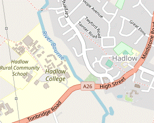 Go down to the A26 at the end of the main driveway and cross the road at the pedestrian lights. Unless you want to
catch a bus from the stop off to the right, turn left and go alongside the main road into the centre of Hadlow, passing the entrance to Hadlow Tower shortly before reaching the bus stop in The Square.
Go down to the A26 at the end of the main driveway and cross the road at the pedestrian lights. Unless you want to
catch a bus from the stop off to the right, turn left and go alongside the main road into the centre of Hadlow, passing the entrance to Hadlow Tower shortly before reaching the bus stop in The Square.
-
After visiting the gardens go back towards the main driveway, keeping to the right of the car park. Veer right onto a surfaced path running parallel to the driveway and follow this out to the A26. Cross the main road at the pedestrian lights.
- If you want to finish the Main Walk without going into the village, the nearest bus stop for Tonbridge is just off to the right; there are other stops on the main road into the village.
- Turn left onto the tarmac walkway between the wide grass verge and a hedge. After crossing the River Bourne you pass Weathered and Worn (which has a small coffee shop) on the right and the Maltings? on the left.
-
In a further 150m you pass an imposing old gateway on the right, one of the few surviving parts of Hadlow Castle and the entrance to Hadlow Tower?.
Note that you are only allowed to enter this private estate when accompanied by one of the Tower stewards on a public open day.
-
Continue alongside the A26 for 100m to The Square in the centre of the village (or the Two Brewers pub 250m further on).
- A short stroll from the back of The Square to St Mary's church? would give you a fine view of Hadlow Tower (and the remnants of Hadlow Castle) over the churchyard wall.
- Broadview Gardens to Hadlow Place Farm (2¼ km)
- … detour into the village, turn right and go alongside the main road for 200m, then turn left into Blackman's Lane. Take the second footpath on the right to go across a large field and keep ahead at a crosspaths. Turn left at a large oast house conversion and head south to Three Elm Lane. Turn left onto the lane, then turn right into the driveway to Hadlow Place Farm.
- …
-
Detour into Hadlow village (up to 1½ km)
- …
- …
- …
- Retrace your steps along the A26 and go past the driveway to Hadlow College.
- Head SW along the A26, away from the village. After passing the Hadlow College bus stop turn left into Blackman's Lane. Ignore the first footpath on the right (after 300m) but turn right at a second, 200m later and opposite the entrance to Bourneside Farm.
- Follow a broad grassy path heading W for 700m, initially with a copse on the left and then between large fields. Follow the path as it veers left and right in front of a large oast house conversion, then turn left by its entrance onto a broad grassy path heading S.
- The path curves slightly right and later goes alongside a line of trees on the left. At the end turn left onto a road (Three Elm Lane), taking care as there is no pavement. In 100m turn right into the driveway to Hadlow Place Farm, which is also a public footpath.
- Hadlow Place Farm to Tonbridge (Big Bridge) (4¾ km)
- Where the farm drive swings left, bear right and head south on field paths for just over 1 km to reach the River Medway. Turn right and follow the riverside path all the way to the A26 at Cannon Bridge. Turn left to go over the bridge, then turn right to continue alongside the river. At Tonbridge Moorings bear left onto Medway Wharf Road to reach the High Street.
-
Go along the farm drive for 150m. Where it swings round to the left bear right to continue on a broad track on the left-hand edge of a large field, heading S with trees on the left.
The OS Map shows the right of way as being inside the belt of trees, but the permissive footpath on the field edge is easier.
- Just before the end of the trees keep left to stay alongside them where the track swings right. Go down a short slope and keep ahead on a path across a large field, still heading S.
- Continue in much the same direction across four fields for 750m, going through gaps in the boundary hedges and crossing a stream on a concrete bridge halfway along. Eventually you come to a path T-junction and turn right, joining both the Wealdway? (WW) and the Medway Valley Walk? (MVW) for the remainder of this section.
- On this riverside path you pass Eldridge's Lock after 800m, then in a further 700m go past the site of a dismantled bridge which used to carry the access road to gravel pits on the far side of the river. After a further 800m you need to fork left to stay close to the river (the right fork goes through a belt of trees into a playing field).
- The path goes between the river and a high fence shielding an industrial estate for 400m, then comes to the outskirts of Tonbridge?. Cross over the busy A26 at the traffic island and turn left, crossing the river on Cannon Bridge. On the other side turn right onto the continuation of the riverside path, with modern apartment blocks on both banks.
- As you pass Tonbridge Town Lock you can see the town's Big Bridge ahead. There is no right of way along the final part of the riverside path, so to reach the High Street you need to veer left onto the adjacent street (Medway Wharf Road) at or soon after Tonbridge Moorings, where the riverside area has been enhanced as part of the Medway Wharf? redevelopment.
- Big Bridge to Tonbridge Station (¾ km)
-
 Tonbridge station is 500m away to the left, but the suggested route is to go straight across the High Street onto River Walk and loop back via Lamberts Yard, continuing along the High Street to the station.
-
For the suggested route to the station (bypassing part of the congested High Street), cross the main road carefully and continue on a broad pedestrian pathway just off to the right (River Walk). You pass Sixty Five MM Coffee and the beer garden of The Humphrey Bean, with a fine view of Tonbridge Castle? across the river.
- At the end of River Walk keep ahead on a cycleway to the left of a modern apartment block (Waterside Lodge). At the far end the path veers right to pass between Tonbridge Memorial Garden? and the river. Immediately after crossing the water channel at Buley's Weir turn sharp left.
- Follow the path into a short side street (Lamberts Yard), passing Nancy's Tea Rooms on the left. At the end turn right onto the High Street, with some more refreshment places on the way to the station: there is a Caffè Nero on the right and the Finch House Café across the road at the front of the Pavilion Shopping Centre.
-
To complete the walk make your way onto the right-hand side of the High Street and follow it up the slope beyond the roundabout. The station entrance is at the top; trains to London usually leave from Platform 2 (down the steps on the left).
- The Greensand Way follows the course of a sandstone ridge just to the south of the North Downs. It runs for 175 km from Haslemere in Surrey to Hamstreet in Kent.
- St Giles, Shipbourne was built in 1881, replacing an earlier church which had fallen into disrepair.
- Hadlow College of Agriculture and Horticulture was established in 1968 and runs a wide variety of land-based training courses.
- The Maltings are on the site of one of Hadlow's former breweries. It was converted into flats in 1990.
- Hadlow Tower is a multi-tiered Gothic folly, built in 1838. It was badly damaged in the 1987 storm and the lantern had to be removed in 1996. A two-year restoration project (including replacement of the lantern) was completed in February 2013.
- St Mary, Hadlow dates from the 11thC, with the tower being added in the 13thC. Its churchyard contains the elaborate Barton May family tomb and – hidden away in the far corner – a monument to 30 hop-pickers who drowned in 1853 while trying to cross the flood-swollen River Medway at Hartlake Bridge.
- The Wealdway runs for 130 km through the Kent and Sussex Weald, from Gravesend on the Thames estuary to the outskirts of Eastbourne.
- The Medway Valley Walk runs alongside the river for 31 km, between Rochester and Tonbridge.
- Tonbridge has always been pronounced Tunbridge and was often spelt that way. The 'o' spelling became standard in the late 19thC to help distinguish it from its spa neighbour Tunbridge Wells, which retained the 'u' spelling.
- Medway Wharf was where barges were loaded and unloaded. The river was made navigable between Maidstone and Tonbridge in the 1740s and was profitable for 100 years, until the coming of the railways. It was claimed to be “the most irregular and worst constructed navigation in England” as it had no towpath and barges had to be hauled by teams of men.
- Tonbridge Castle dates from the 13thC, with the imposing gatehouse being completed in 1260. An earlier motte and bailey castle was destroyed after a failed rebellion against William Ⅱ in 1088. The site is now owned by the local council and the grounds are a public park.
- Tonbridge Memorial Garden was created after World War Ⅱ “in grateful memory of the men of this town who died in the service of their King and Country”.
In this section along the GW you will be following (in reverse) part of the route of Walk #41.
If you are doing the Extended Walk (to Tonbridge), go to §H.
In Tonbridge the High Street bus stop is convenient for refreshment places and the Quarry Hill Parade stop is the closest to the station. However, you might like to alight earlier at the Tonbridge Castle stop to visit the ruins, completing the walk with the short route in §J (or perhaps one of the extensions suggested in the Introduction).
If you want to make an out-and-back detour into the village before starting the extension (along the A26 to the right), follow the directions below as far as you wish.
Walk Notes
» Last updated: October 23, 2023
Return to Top | Walk Map | Walk Options | Walk Directions.