Hollingbourne Circular walk
A choice of ridge walks on the North Downs followed by a circuit around the grounds of Leeds Castle


CIMG2927
The Shepherd sculpture
Jul-14 • Sean O'Neill
swcwalk221, swcwalks, walkicon 6047395611567904386 P

CIMG2999
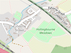
Hollingbourne Meadows
Jul-14 • Sean O'Neill
swcwalk221, swcwalks, walkicon 6167227630939370850 P

CIMG4206
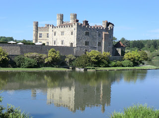
Ancient sweet chestnut, Leeds Castle
Aug-14 • Sean O'Neill
swcwalk221, swcwalks, walkicon 6047396771885477442 P

CIMG8475
St Margaret's church, Hucking
Jun-15 • Sean O'Neill
swcwalk253, swcwalks, walkicon 6167266839972594578 P

| Length |
Main Walk: 15½ km (9.6 miles). Three hours 45 minutes walking time. For the whole excursion including trains, sights and meals, allow at least 8 hours. Extended Walk 1, via Thurnham: 22¼ km† (13.8 miles). Five hours 40 minutes walking time. Extended Walk 2, via Hucking: 20 km† (12.4 miles). Four hours 50 minutes walking time. Long Walk, with both extensions: 26¾ km† (16.6 miles). Six hours 50 minutes walking time. † Subtract 5¾ km (3.6 miles; 1 hour 30 minutes) if omitting the Leeds Castle circuit. |
|---|---|
| OS Map |
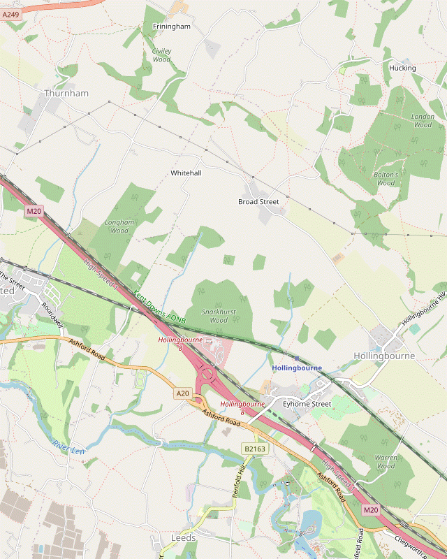
Explorer 148. Hollingbourne, map reference TQ833551, is in Kent, 8 km E of Maidstone. |
| Toughness |
4 out of 10 (7 for Extended Walk 1, 5 for Extended Walk 2, 9 for the Long Walk). |
| Features |
For much of the train journey you can see the North Downs ridge off to your left and from the station you are soon striding across vast farm fields to meet the North Downs Way (NDW) at the foot of this open downland ①. The Main Walk swings back towards Hollingbourne at this point, climbing the ridge and continuing along the southern edge of the Woodland Trust's Hucking Estate, an unexpected oasis of grassland and woodland in a landscape dominated by arable farming ②. It then drops back down the hillside to Upper Street, one of the three settlements which make up Hollingbourne village. The walk concludes with a contrasting section on the other side of the village. After going through the deceptively peaceful Hollingbourne Meadows you have to suffer the constant roar of motorway traffic, high-speed trains thundering past and a dreary stretch alongside the busy A20. This dismal link route is the price you pay for some stunning views of a famous castle as you traverse its grounds on public rights of way. Modestly describing itself as “the Loveliest Castle in the World”, the moated setting of Leeds Castle is certainly spectacular. Built by a Norman knight in 1119, it became a royal residence for 300 years in the Middle Ages, then a private home in Tudor times. Its last private owner was an American heiress who undertook extensive renovations and left it to a charitable trust in 1974. If you want to visit the castle buildings or deviate from the public footpaths you would need to buy an entrance ticket for £35 (2024), although this is effectively an annual pass as it allows unlimited repeat visits for a year. |
| Walk Options |
At the two points marked above you could extend the outward leg with an extra circuit: ① Extension 1 joins the NDW in the opposite direction for a 6¾ km circuit via the small village of Thurnham. This starts with an undulating stretch across a succession of sunken lanes and hollows in the hillside, loops around a small country park containing some medieval castle ruins and returns via parkland, field edges and paddocks. ② Extension 2 makes a longer exploration of the attractive Hucking Estate. This 4½ km circuit goes out along grassy rides and woodland paths to the tiny hamlet of Hucking and loops back along a wide open valley. The unsatisfactory nature of the link route to and from Leeds Castle means that this final leg will not be to everybody's taste. If you have done one (or both) of these extensions you could choose to go directly to the station from Upper Street, but the suggested shorter ending takes a different route to Hollingbourne Meadows before heading back via Eyhorne Street. |
| Additional Note |
The Thurnham and Hucking extensions were previously published as separate walks (#221 & #253). After several tweaks there was so much overlap between them that they have been combined here into a single walk plus optional extensions. |
| Transport |
There is an hourly off-peak service from London Victoria to Hollingbourne (on the London–Maidstone–Ashford line), taking about 1 hour 15 minutes. There is a regular bus service to Maidstone along the A20 (Stagecoach 10X, not Sun), but only an infrequent weekday service (Nu-Venture 13) from Hollingbourne church through Eyhorne Street. If driving, there is a small free car park at Hollingbourne station. |
| Suggested Train |
Take the train nearest to 10:00 from Victoria to Hollingbourne. |
| Train Times |
|
| Timetables |
|
| Lunch |
The suggested lunch pub on the Main Walk (after 7½ km) would normally be the Dirty Habit (01622-880880) in Upper Street (Hollingbourne). However, this pub is being renovated after a serious fire in October 2022 and its scheduled reopening date (currently Autumn 2024) has been put back several times. The alternative is less convenient as it requires a short detour down the A20 before entering the Leeds Castle grounds. The Park Gate Inn (01622-880985) is a Vintage Inns pub which normally serves food all day and has a large (though not quiet) beer garden. There are earlier pubs on both of the Extended Walks. After 6¾ km on Ext ① the Black Horse (01622-737185) in Thurnham has a patio garden at the back and serves a good selection of à la carte and regular pub meals. After 8 km on Ext ② the Hook & Hatchet Inn (01622-880272) in Hucking has a particularly attractive garden and serves “simple and delicious” home-cooked food all day. |
| Tea |
At the start of 2024 a new Community Interest Company opened the Signal Box Café at Hollingbourne station. It currently has limited opening hours (to 4pm on Mon/Wed/Fri only) but the group hope to open on weekends; they also plan to open a community shop. About ten minutes before the station there are two pubs in Eyhorne Street. The Windmill (01622-889000) is an up-market pub / restaurant, while the Sugar Loaves (01622-880220) is a more traditional village pub. Both have back gardens away from the street. There are several places inside the grounds of Leeds Castle but prominent notices state that walkers are not entitled to stray from the public footpaths. The staff are unlikely to object if you pause at one of the seasonal kiosks along the way, but you should ask for permission before attempting to visit the cafés or using the seating provided for castle visitors. |
| Profile | |
|---|---|
| Help Us! |
After the walk, please leave a comment, it really helps. Thanks! You can also upload photos to the SWC Group on Flickr (upload your photos) and videos to Youtube. This walk's tags are: |
| By Train |
Out (not a train station) Back (not a train station) |
| By Car |
Start ME17 1TX Map Directions |
| Amazon | |
| Help |
National Rail: 03457 48 49 50 • Traveline (bus times): 0871 200 22 33 (12p/min) • TFL (London) : 0343 222 1234 |
| Version |
Apr-24 Sean |
| Copyright | © Saturday Walkers Club. All Rights Reserved. No commercial use. No copying. No derivatives. Free with attribution for one time non-commercial use only. www.walkingclub.org.uk/site/license.shtml |


Walk Directions
Click the heading below to show/hide the walk route for the selected option(s).
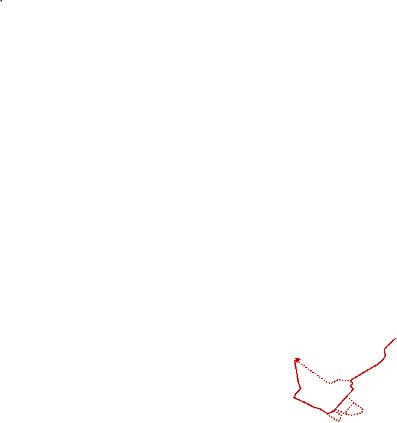


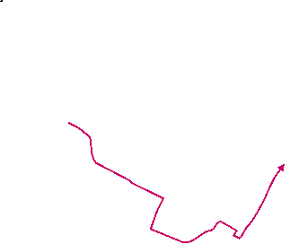


 Walk Map
©
Walk Options ( Main | Ext ① | Ext ② )
Click on any option to show only the sections making up that route, or the heading above to show all sections.
- Main Walk (15½ km)
Walk Directions
Click on any section heading to switch between detailed directions and an outline, or the heading above to switch all sections.
- Hollingbourne Station to Broad Street (1¾ km)
- Leave the station on a new pathway from Platform 2, back alongside the tracks. Continue on a footpath along the edge of a field. In the corner cross a stream in the tree boundary and follow this little-used footpath northwards across large farm fields to the hamlet of Broad Street.
-
Arriving from London on Platform 2, do not cross the footbridge to the main station exit but go through a gate by this bridge onto a new “public wayside path” going back alongside the tracks. Where this new path ends at a former crossing point (closed by Network Rail in 2019) continue in much the same direction near the field edge, ignoring a footpath across the field.
Be aware that the right of way across the farm fields in this section has not always been clearly marked out.
- In the field corner veer left through the tree boundary on a short path which crosses a ditch on a plank bridge and emerges into the bottom corner of a large irregularly-shaped field. Follow a faint path going diagonally up across it, heading NNW towards the left-hand end of a clump of trees projecting into the field, 250m away.
- On reaching these trees bear right to head towards the right-hand side of a wide gap 150m away, with the North Downs visible beyond. After passing between two pine trees carry on alongside the wood on the right-hand side of the gap. Halfway along ignore a footpath off to the left, but at the end of the trees bear slightly left across the field, heading N.
- The field path becomes less distinct after you cross a field boundary, but the right of way continues in the same direction. Aim for the right-hand end of another line of trees, then bear slightly right towards the corner of a hedge 200m away. On reaching the hedge bear right to go alongside it.
- Halfway along turn left through a gate in the hedge into a meadow. Turn half-right and follow a grassy path to another gate, which leads out onto a lane in the smallest part of Hollingbourne?, Broad Street.
- Broad Street to Coldharbour Lane (1¼ km)
-
Turn left onto Pilgrims Way. In 600m take the left-hand of two footpaths on the right, across a large field. Near the far side veer left to meet the North Downs Way on a byway (Coldharbour Lane) below Cat's Mount.
- If you are not doing the Thurnham loop, turn right onto the byway.
- Turn left and follow the lane (Pilgrims Way?) through the hamlet for 600m. The turning off this lane is easy to miss. After passing the last house the road bends left and there is a metal fieldgate on the right; ignore this, but in a further 25m go through a narrow gap in the hedge on the right (by a tree) into a large field.
- Although not signposted there are two footpaths across the field from this point, faintly marked out at the time of writing. Take the long straight left-hand path going diagonally across the field, climbing gently and heading NNW. The path goes under power lines and crosses a horse track.
-
The exit from this field is not the stile in the hedge ahead, but a gap leading out onto the track beyond the left-hand field edge (with a grassy path up the hillside beyond it, the route of the Thurnham extension). The suggested route is to go up to the far side and then turn left to head for this exit, either directly or around two field edges.
There is in fact another right of way across the field leading to this gate, although there was no trace of a path on the ground when last checked.
- At the field edge go up a low bank onto the track (Coldharbour Lane). There is a waymarker post indicating that this is a byway (and a yellow waymarker pointing back across the field to confirm the indiscernible right of way).
- Coldharbour Lane to White Horse Wood Country Park (2 km)
- Go straight across the byway to climb Cat's Mount. On this undulating stretch of the NDW you have to cross several deep hollows, including Coldblow Lane. Where the NDW turns sharply left in one of these hollows, veer right up the slope to a lane (Castle Hill). Go across this into White Horse Wood Country Park.
- For Extension 1 go straight across the track and through the wooden gate ahead, joining the North Downs Way? (NDW). Follow the path up the hillside (Cat's Mount) and go through a metal kissing gate to continue up a flight of steps.
- The path levels out and goes along the top of the wooded ridge for about 300m, then makes a long descent. At the bottom go past vehicle barriers and straight across a minor road (Coldblow Lane). Ignore a footpath off to the left to stay on the NDW, past another vehicle barrier.
- After climbing gradually for 400m you come to a path junction and fork left with the NDW, down a long flight of steps and then along an undulating stretch. Eventually you go through a metal kissing gate to continue on a fenced path, with a field sloping up to the right.
-
In 200m the path drops down to a wide gap between this field and the one below, with the NDW making a sharp turn to the left.
- For a more direct route (bypassing the ruins of Thurnham Castle at the top of the wooded escarpment off to your left) you could go through the metal kissing gate ahead and follow the NDW southwards for 300m, rejoining the route down from the castle by another kissing gate. If you take this short cut, resume the directions at [?] in §D.
- For the suggested route, veer right at this gap to go uphill; this is a right of way although there is no clear path. As the hedge at the top of the field comes into view, aim for a metal kissing gate near its left-hand end. Go through this and turn left to reach a lane (Castle Hill), with an information panel for White Horse Wood Country Park? opposite.
- White Horse Wood Country Park to Thurnham (1¾ km)
- Follow the perimeter path around this small country park, either turning right to go round anti-clockwise or turning left for a much shorter route. Go back across Castle Hill to the ruins of Thurnham Castle, then steeply down the castle mound to rejoin the NDW. Follow this out to Castle Hill and down the lane to the Black Horse pub in Thurnham.
-
Follow the track into the country park. This actually leads to a private property in the centre, but soon there are gaps in the fences on both sides where the track is crossed by the perimeter path around the park.
- For a more direct route (cutting out the Woodland Walk circuit around this small park) you could go through the gap on the left and follow the path southwards beside an avenue of memorial trees, rejoining the main route at a triangular path junction towards the end of this avenue. If you take this short cut (saving 750m), resume the directions at [?].
- For the main route, go through the gap on the right and follow the all-weather path to the left of the car park, into a wood and round several left-hand bends. At a junction fork left as indicated to reach a fine viewpoint.
- From the viewpoint the path goes along the right-hand side of an open area (the site of an Iron Age Enclosure) and comes to an avenue of memorial trees. Keep right at a triangular path junction, where the short cut joins from the left.
-
Go through a metal kissing gate and across a grassy area to return to Castle Hill. Go straight across this lane into the site of Thurnham Castle?. After going past its ruined walls, climb to the top of the mound for another fine view.
- To avoid the awkward descent described below you could return to Castle Hill and follow the lane downhill into Thurnham.
- The more exciting way down from the castle grounds is via a path into the trees from the summit. This drops steeply downhill to a squeeze gate, after which a flight of steps provides a less precarious route down the rest of the hill. At the bottom turn right at a path T-junction, where the NDW comes in through a metal kissing gate on the left.
- Follow the woodland path out onto Castle Hill at a hairpin bend. Keep left and go downhill on the lane for 250m into the small village of Thurnham. At the crossroads with Pilgrims Way the Black Horse pub is ahead on your right.
- Thurnham to Coldharbour Lane (3 km)
- Head east along Pilgrims Way, then take a footpath on the right cutting through parkland towards Thurnham Keep Farm. Turn left onto a driveway and continue along a field edge towards Cobham Manor, where the footpath has been diverted. Turn right, either staying in the field edge or going along Water Lane. In 300m turn left onto the new footpath route and follow it across fields and paddocks. At the end turn left onto Whitehall Lane. Cross Pilgrims Way and take the byway opposite, returning to the NDW below Cat's Mount.
- Turn right out of the pub and keep ahead at the crossroads to head E on Pilgrims Way, taking care on this narrow sunken lane as there is no pavement. In 250m turn right onto an easily-missed footpath, going over a stile in the hedge. Turn half-left as indicated and follow a faint grassy path diagonally across a strip of parkland containing some fine trees.
-
In the far corner go through a gate and turn left onto a driveway, passing a house. In 250m go through another gate and continue past a few more houses. Where the driveway swings left, keep ahead along the edge of a large field to the next corner.
The right of way used to go straight ahead from this corner (through the Equestrian Centre) but has been diverted to bypass it on a more southerly route.
- For the new route turn right at the corner to continue around the field edge, now with a minor road (Water Lane) behind the hedge on your left. In 300m turn left down a few steps onto the road.
- Cross Water Lane and go through a metal gate onto the signposted footpath opposite, parallel to a driveway on the right and heading ESE. Continue along the right-hand edge of several paddocks for 300m, passing through gates along the way. Eventually you go through a belt of trees into the corner of another large field divided into paddocks.
- Turn half-left here as indicated to cut across this field, heading ENE and negotiating several fences with horse tape along the way. Near the midpoint of the far side, a footpath marker post directs you through one final fence onto a narrow path going gently uphill through a belt of trees.
- When level with the top of the field veer right onto a potentially overgrown tree-lined path, now back on the original footpath route. In 175m turn right as indicated and follow a broad fenced grassy path around two sides of an orchard. At the end turn left onto a minor road (Whitehall Lane) and follow it to a T-junction with Pilgrims Way.
- Turn left briefly onto this road and almost immediately veer right onto a byway (Coldharbour Lane again), climbing gently towards the North Downs (you might recognise the large field on the right as the one you crossed in §B). Keep ahead at the path crossing below Cat's Mount, rejoining the NDW but now in the opposite direction.
- Coldharbour Lane to Bolton's Wood (2½ km)
-
Follow the byway around a hollow. At the top fork right and follow the NDW along the side of the downs, through a wooded section for 600m and then the same distance across open downland. Go across Broad Street Hill and continue briefly along the NDW, then turn left into the Woodland Trust's Hucking Estate. Follow the North Downs Way Link route through grassland on the estate's southern boundary, passing “The Shepherd” at a viewpoint and coming to a gap between Bolton's Wood and Forestall Wood.
- If you are not doing the Hucking loop, fork right to stay on the NDW Link.
- Follow the byway as it curves round to the left along the side of a hollow, then swings sharply round to the right to climb the other side. At the top of this straight section fork right off the byway where it turns left, as indicated by a NDW waymarker.
-
Follow this gently undulating path through the trees for 600m, ignoring footpaths off to both sides halfway along. At the end of the trees go through a metal gate onto open downland above the hamlet of Broad Street. Keep ahead on a well-trodden grassy path for a further 600m to a tree boundary in front of a lane.
The OS map shows the NDW deviating from this path (sometimes below and at other times above it, presumably conforming to ancient field boundaries), but in practice most walkers take the suggested direct route.
- At the tree boundary veer left up to the top corner of the downland, go over a stile and turn right. Cross a sunken lane (Broad Street Hill) via a few steps on each side and continue along the NDW. You soon come to a prominent three-way signpost where you turn left onto the signposted North Downs Way Link (waymarked with yellow arrows), entering the Hucking Estate?.
- In front of a Woodland Trust information panel turn right onto a permitted horse ride, parallel to the NDW. In 75m go through a metal kissing gate on the left and continue in much the same direction across open grassland, dotted with gorse bushes. A mown path from a low marker post among these bushes leads to a life-size wooden sculpture of The Shepherd?, gazing out over the Weald at a fine viewpoint.
- Continue along the mown path, passing an information panel about the sculpture. Shortly before the grassland narrows between Bolton's Wood (on the left) and Forestall Wood you pass another marker post, with a yellow arrow indicating that the NDW Link carries on across the grassland.
- Bolton's Wood to Hucking Bank (1¾ km)
-
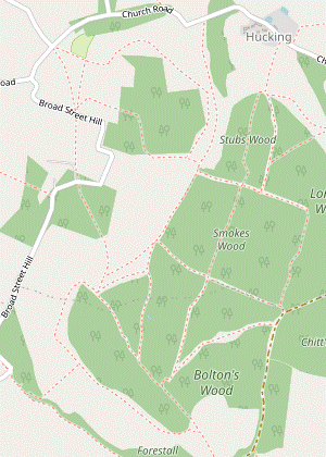 Follow the Landscape Trail round to the left into Bolton's Wood. Turn right at a path junction onto a long straight ride through this wood and Smokes Wood, then on a woodland path through Stubs Wood. Join a bridleway leading out to Church Road and turn left to go through the hamlet of Hucking. In 200m re-enter the Hucking Estate via a track on the left.
- For Extension 2 fork left at the marker post. Follow the mown path through the gap and round to the left to come to a metal kissing gate in a wire fence.
- Go through the kissing gate and follow a grassy path into Bolton's Wood. In 200m turn right at a path junction, staying on the Landscape Trail.
- Where the path swings right and comes out into a more open area, take the left-hand of two broad grassy rides, heading NNE. In 350m you come to a path crossing with the second wooden sculpture, The Living Log?.
- Go straight ahead at this junction, into Smokes Wood. In a further 350m keep ahead again at the next path crossing (with a small tree in the centre), into Stubs Wood.
- The woodland path swings left and right through a dip, then straightens out. It eventually bends right and you go out past a wooden barrier to leave the wood.
- Turn left (leaving the Landscape Trail) and follow a broad grassy track towards Hucking church, with a meadow and then a new Community Orchard on the left (which you could wander around). At the end of the track turn left onto a lane (Church Road), where St Margaret's church? is worth a quick visit, if open.
-
Continue along Church Road for 200m, with glimpses of the Isle of Grain 16 km away to the right. Shortly after the lane bends left and starts to descend, fork left onto a track leading back into the Hucking Estate, going through a wooden gate into the top corner of a valley.
- Hucking Bank to Hucking Valley (1½ • ½ km)
-
For the main route go straight across the valley and up the other side. Go round a wood on the left to emerge onto an open plateau. Turn right and go along its edge to the next corner, with the Hook & Hatchet Inn just outside on a lane. Return to the plateau and go diagonally across it to the opposite corner. Follow a winding path through Calves Wood, later dropping down to a gap between two valleys.
- If you are not visiting the pub you could simply go down the valley for 500m.
-
Main route (1½ km)
- Go straight ahead across the valley floor and up the other side, aiming for the right-hand end of the wood on the far side. Go around the right-hand side of these trees and along a broad strip of grassland, curving round to the left. At the end go through a gate on the left into the corner of a grassy plateau.
- Turn right and make your way across the grassland towards the right-hand corner; slightly away from the edge there is another wooden sculpture, The Tranchet Axe?. To visit the pub go out through a gate in the corner and turn right onto a lane for the Hook & Hatchet Inn.
- To resume the walk, return to the plateau and go diagonally across it to the opposite corner. Ignore a gate leading out to a lane and go through another gate to its left. Continue on a potentially muddy path between a wood and a hedge, parallel to the lane on the right.
- Ignore another exit to the lane and stay on the woodland path, which zig-zags left and right. Soon after this second turning it goes down a short flight of wooden steps to a T-junction. Turn right and follow the path as it winds its way through Calves Wood, gradually turning more to the left.
- After a long straight stretch keep right to go downhill on a narrow path alongside a belt of trees. At the bottom go through a gate into a gap between two open valleys, where the short cut rejoins from the left.
-
Short cut (½ km)
- Turn left and go along the side of the grassy bank, gradually dropping down towards the valley floor. The valley curves gently to the right and leads you towards a wide gap in the trees with a double fieldgate, where the main route rejoins from a path on the right.
- Hucking Valley to Bolton's Wood (1¼ km)
- Go along the grassy valley for 600m, gradually curving to the right. At the far end turn left by “The Wild Boar Family” and go through a gate into Bolton's Wood. Follow a grassy path heading south-east through the trees, eventually retracing your outward route for a short distance.
-
If the double fieldgate in the gap is unlocked the suggested route is to go through it and walk along the grassland in the centre of the valley, but you could also take the enclosed path on the left-hand side of the valley floor (which is a right of way and also part of the Landscape Trail).
- If you take the enclosed path you should go through a side gate into the grassland after 300m, as indicated by a waymarker for the Landscape Trail.
- Either way, continue along the valley floor for a further 300m, gradually curving to the right and coming to the final wooden sculpture The Wild Boar Family? in front of a fence. Turn left at the sculpture and go towards a gate in the corner of the valley, under a large tree.
- Go through the gate and keep ahead on a long grassy path through Bolton's Wood, heading SE. Ignore side paths, including the one on the left you took at the start of this circuit. At the end of the wood go through a kissing gate and keep ahead across the open grassland.
- Bolton's Wood to Upper Street (2 km)
- Leave the Hucking Estate in its south-eastern corner and turn right onto a byway. In 125m turn left to rejoin the NDW, initially heading south-east through a lightly wooded area, then out onto open downland. After skirting a large depression (Eden's Hole) stay on the NDW as it slants down across the face of the downs, then turns right. Continue alongside a sunken lane (Hollingbourne Hill), eventually dropping down onto it to reach the Dirty Habit pub in Upper Street.
- At the end of the grassland leave the Hucking Estate through a wooden side gate. Turn right onto a potentially muddy byway and follow it for 125m to a NDW Link signpost and Woodland Trust information panel.
-
Turn left off the byway, going through a wooden gate and rejoining the main NDW. Follow a winding grassy path through a lightly wooded area, heading roughly SE. In 200m the path passes under power lines and later emerges onto open downland.
You might just be able to make out Leeds Castle, nestling in the trees 3 km ahead.
- Follow the NDW round to the left as indicated. In front of you there is a large wooded depression (Eden's Hole) and the NDW has to swing left to get around it, with a stretch along a fenced grassy track beside a huge farm field. The track eventually swings right to re-emerge onto the downs.
-
The NDW now descends gently for 250m; a potentially awkward little stretch through a copse can be bypassed by a well-trodden alternative path skirting around it to the right. The NDW then goes through a gate and levels off, curving round to the left. In 200m turn right at a footpath marker post onto a mown path sloping down the hillside.
This marker post was missing when last checked (vandalised?) but the path down the hillside was clear enough.
- At the bottom follow the path through a copse to a wooden fieldgate. Go through a side gate and along the left-hand edge of a field, with a sunken lane (Hollingbourne Hill) down to your left.
- In 200m veer left to continue on a short narrow path above the lane. After joining the lane you soon come to a crossroads with Pilgrims Way, with the Dirty Habit pub at the top of Upper Street in the main part of Hollingbourne?.
- Upper Street to Hollingbourne Meadows (1½ km)
-
 Continue briefly along the NDW and turn right onto a footpath going round the eastern edge of the village, then along a belt of trees beside a road. Follow the road round to the right and turn left onto a footpath going under the railway line. Take any route through Hollingbourne Meadows to a small meadow on the far side.
- From the crossroads take the narrow lane heading SE, passing the pub's patio garden and main car park on your right. In 125m, at the end of the houses, turn right onto a fenced path to the left of a driveway, signposted as a footpath and leaving the NDW.
- After passing some gardens the path zig-zags right and left and comes out onto a driveway, bringing you back to the road at a sharp bend. Instead of joining the road veer left onto a signposted footpath into the wide belt of trees alongside the road.
- Go all the way along this path, about 300m. At the far end cross Greenway Court Road onto the roadside path opposite. After passing a school playground continue along the pavement of Eyhorne Street as it goes round a right-hand bend.
- In 50m turn left into an easily-missed alleyway on the left, with a yellow footpath waymarker. Go straight across Culpeper Close onto a broad track, past a metal fieldgate and under a railway bridge into Hollingbourne Meadows?.
- For the direct route, keep ahead along a broad grassy avenue lined with memorial trees, passing a grazing enclosure (Godfrey Field) on your right. At the end of the avenue go straight over a crosspaths and through a gap in a hedge.
- Cross a ditch on a plank bridge and follow the mown path curving round to the top right-hand corner of a wildflower meadow. Do not go through the gap ahead into the next meadow but turn left to go up the edge of a large field, with a hedge on your right.
- At the top of the slope go through a gap into the corner of another small meadow with two mown paths ahead, with the full walk continuing along the left-hand path.
- Hollingbourne Meadows to the Great Water (2 km)
-
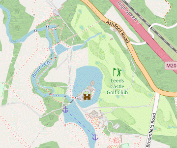 Keep to the left of the small meadow and continue on a footpath across the high-speed railway (HS1) and the M20. Turn left onto the A20, then in 175m turn right into Leeds Castle grounds. Head south-west through a wood, across two golf fairways and down to Cedar Pond. Go past this and follow the right of way through parkland, gradually curving round to the left and eventually going alongside the Great Water towards the Gatehouse.
- For the full walk take the left-hand path and continue along a broad grassy track between a fence and a hedge, ignoring a small metal gate with a yellow footpath marker on the left (the return route from Leeds Castle). Where the grassy track swings round to the right keep ahead on a narrow enclosed path, also with a yellow waymarker.
- At the end of this short but potentially overgrown path go over a stile and follow a faint grassy path near the left-hand edge of a small field. In the top corner go over another stile to continue along the top of a field, with the high-speed railway (HS1) behind a hedge on your right.
- Near the end of the field go over a stile on the right to cross both HS1 and the M20 motorway on footbridges. Follow the path through a small wood to the A20 and turn left onto the tarmac path running alongside it.
-
When you have a clear view in both directions in the next 175m cross this busy main road with great care. Continue along the grass verge to a signposted footpath into woodland, which is the continuation of the walk.
- If you want to visit the Park Gate Inn carry on along the main road for a further 125m to the pub. Return the same way and turn left into the castle grounds.
- Go through an old gate onto a short woodland path leading to a golf course, where the right of way continues across two fairways. After emerging from the trees you should ring the bell to alert golfers playing from over the brow of the hill on the right.
-
After crossing the second fairway keep ahead through a copse. Continue across an estate road and go down a slope between rhododendrons to a tarmac path.
The main visitor entrance is 250m to the right along this tarmac path (signposted “Exit”). It is not a right of way but the staff could hardly object if you used it in order to buy an entry ticket to the castle.
- To continue the walk keep ahead alongside Cedar Pond, with a fine view of the castle beyond it. At the next path junction bear left past a large cedar tree and go through a kissing gate into parkland.
- Bear right up a broad grassy path which passes to the right of a clump of trees, then curves left to head SW alongside a low fence. At the end of the fence keep left, now with a line of trees on your right.
- On the brow of the hill bear left to go downhill on another broad grassy path, now heading SE. Shortly before this merges with a driveway coming in from the right, fork left to stay on the grassy path.
-
At the far end go up a short slope and out past a wooden gate onto the driveway. Bear left and and follow it downhill to the Great Water, with a seasonal kiosk (the Whistle Stop Café) at the lakeside.
- The Great Water to Greenway Court Road (1½ km)
- Turn right in front of the Gatehouse, then left to stay alongside the moat. Go across another golf fairway and continue alongside an estate road. Veer left in front of a vehicle exit and follow a path through trees and up steps to a lane. Head east alongside the A20, under the M20 and HS1, then turn left into Greenway Court Road.
- Go alongside the lake towards the Gatehouse, then round to the right between the lake and the moated castle. At the entrance to the Restaurant and other attractions turn left to stay alongside the moat, with increasingly fine views of the Maiden's Tower and other castle buildings.
- Keep ahead past a “No Entry” sign onto the golf course (this is still a right of way), with an estate road on your right. Take care as you cross a golf fairway and continue on a broad tree-lined avenue. Just before a vehicle barrier at the edge of the grounds, veer left onto a path into the trees.
- Follow this path past a golf green and up steps on the right to a lane (Broomfield Road), leaving the castle grounds. You will soon have to endure a fairly long stretch alongside the A20, but the footpath opposite cuts off a small part of it: cross the lane carefully to follow this short path round the back of a golf tee and down an overgrown bank to the main road.
- When you have a clear view in both directions cross the A20 with great care and turn right onto the tarmac path running alongside it. Continue alongside the busy road for 500m, passing under the M20 and HS1, then turn left to go a short distance along Greenway Court Road.
- Greenway Court Road to Hollingbourne Meadows (2 km)
- Take a footpath on the left across a field and through Warren Wood to Hospital Lane. Turn right onto the lane and take the first footpath on the left, through Coombe Wood. Continue along field edges and past a paddock to return to Hollingbourne Meadows. Go into a small meadow and turn left.
- At the end of the pavement turn left again onto a footpath across a field, heading NW towards Warren Wood. At the trees bear left to continue along the field edge, with the wood on your right. At the end of the field go into the trees and follow a potentially muddy woodland path for 350m.
- As you approach a lane there are signs of a new development and the onward route might not be clear, but make your way out to the lane (Hospital Road) and turn right onto it. You pass an isolated house on the left, then in 50m turn left onto a signposted footpath.
- Once again you follow a clear woodland path for about 400m. After turning half-right and then back to the left this heads W in a fairly straight line. The path eventually leaves the wood past an old stile and you continue in the same direction along a field edge, at first with the wood on your right and later a tall hedge.
- In the field corner keep ahead past a copse on the left to continue on a narrow fenced path beside a paddock. At the end go through the small metal gate you passed earlier. Cross over your outward route in Hollingbourne Meadows, then almost immediately turn left at a path crossing to head SW on a mown path near the edge of the meadow.
- Hollingbourne Meadows to Hollingbourne Station (1 km)
- Leave the meadow and turn right onto a farm track. Follow it across a stream, past farm buildings and along a driveway into Eyhorne Street. Take the footpath off the north side of the main village street, between its two pubs. At the end of an enclosed path turn half-left to continue across two fields. Cross a farm track and go down a short path to the station.
- Follow the mown path out though a wide gap in the hedge and turn right onto a farm track. This goes down a slope and swings right and left, crossing a stream. Go through a gate and follow the track to the right of some farm buildings. Keep right to continue on a driveway, soon passing the Village Hall and then a pub car park on the right.
- The two refreshment places in Eyhorne Street are on the village street ahead, but you can access both of them from this car park. The beer garden for the Windmill pub / restaurant is straight ahead, and off to the right a sign for the Sugar Loaves leads to steps down into the other pub's car park.
- To complete the walk take the signposted footpath on the north side of the main village street, between its two pubs (nearer the Sugar Loaves and opposite the Village Shop). Keep right to continue on an enclosed path to the right of Magnolia House. At the end go over a stile into the corner of a field and turn half-left, aiming for a gap in the hedge 75m away (not one in the opposite field corner).
- Go through this gap and bear slightly right up a larger field, passing to the right of an isolated tree. At the top cross a farm track via a couple of awkward stiles and go down a new pathway to the station. Platform 1 on the near side is for trains to London.
- Upper Street to Hollingbourne Station (2¼ km)
-
Go down the main village street, then through the churchyard and along a path across a field to Eyhorne Street by the primary school. Turn left and go via Culpeper Close to a footpath going under the railway line. Take any route through Hollingbourne Meadows to the exit on its western side and continue along a residential street
?
- From the crossroads go down Upper Street, passing several fine old houses including Hollingbourne Manor? on the right at the far end. Follow the street round to the left and turn right into Church Lane.
-
At the end of this short street go through its lychgate into the churchyard of All Saints?, which is worth a visit. Follow the surfaced path through the churchyard and across a field to come to Eyhorne Street by Hollingbourne Primary School.
- Hollingbourne station is 600m away. If you want to go there directly, turn right onto the road. After passing under the railway bridge turn right again into the long station approach road.
- To continue the walk, turn left onto Eyhorne Street, then turn right into Culpeper Close. Follow this street round to the left and then turn right again onto a broad track, signposted as a footpath. Go past a metal fieldgate and under a railway bridge into Hollingbourne Meadows?.
-
?
- On entering the first meadow you could veer off to the left and go all the way around its perimeter, which would lead you round to the far end of the avenue (or take a path through the middle of the meadow for a shorter loop).
-
?
Go straight over a crosspaths and through a gap in the hedge into a third meadow.
- Again, on entering the wildflower meadow you could veer off to the left for a longer loop around it.
- Go all the way along the left-hand side of the third meadow to leave Hollingbourne Meadows in the far corner. In 60m keep ahead on this public footpath, joining the driveway coming in from a large house off to the left. In 100m the drive comes out onto a road (Eyhorne Street) at its junction with Hasteds.
-
Continue in the same direction on Eyhorne Street, soon crossing a stream and going through another part of Hollingbourne?. The village's two refreshment places are on the left-hand side in the next 150m, the Sugar Loaves pub followed by the Windmill pub / restaurant.
- ?
- ?
- Hollingbourne is made up of three settlements, with the main part (around the church) being called Upper Street to distinguish it from Eyhorne Street (near the station) and Broad Street (on Pilgrims Way). The village is a conservation area and contains many historic properties.
- Pilgrims Way is a 192 km route between Winchester and Canterbury, although there is no real evidence that it was used by medieval pilgrims to the shrine of Thomas Becket. The name was added to OS maps by a 19thC surveyor after the legend was embellished by Hilaire Belloc and other writers. Much of the route actually follows an ancient trackway on the southern slopes of the North Downs, linking the narrowest part of the English Channel to the sacred sites of Stonehenge and Avebury.
- The North Downs Way runs for 246 km along the length of the North Downs (with two sections at its eastern end), from Farnham in Surrey to Dover in Kent.
- White Horse Wood Country Park was established by Kent County Council as a Millennium site in 2000.
- Thurnham Castle is a typical motte and bailey castle dating from the 12thC. The large motte (artificial mound) is still visible but the only remaining stonework is on one side of the bailey (courtyard) wall.
- The Hucking Estate was bought by the Woodland Trust in 1997. They have gradually been reversing the changes to the landscape brought about by modern farming practices, restoring large areas of woodland and chalk grassland.
- The Shepherd, The Living Log, The Tranchet Axe and The Wild Boar Family were designed and carved in 2012 by two local artists, Nick Speakman and Rob Dyer. They were commissioned by the Woodland Trust to illustrate the Hucking Estate's habitat and heritage.
- St Margaret, Hucking dates from the 12thC, but it was substantially rebuilt in 1878 and there are few traces of the medieval church.
- Hollingbourne Manor is an Elizabethan manor house dating from the late 16thC.
- All Saints, Hollingbourne dates from the 14thC, with several later extensions. It contains numerous monuments to the Culpeper family (at one time owners of Leeds Castle and Hollingbourne Manor), notably a fine marble sculpture (1638) by Edward Marshall in the Culpeper Chapel of Lady Elizabeth on her tomb chest; the mythological creature at her feet is a theow, her maternal family's heraldic beast.
- Hollingbourne Meadows were bought by a local trust in 2004 to protect the village from “inappropriate or insensitive use”. A large area to the east of Eyhorne Street is managed as a wildlife haven with broad grassy paths to encourage use by walkers.
Unless you are doing Extension 1 (the Thurnham loop) turn right onto the byway and continue the directions at §F.
Unless you are doing Extension 2 (the Hucking loop) fork right to stay on the NDW Link and continue the directions at §J.
Part of the walk route follows the Hucking Estate's “Landscape Trail”, but at the time of writing the Woodland Trust have only waymarked it in the reverse direction (so you will sometimes see green arrows on the back of their low marker posts).
The main route loops around the north-western corner of the estate where there is a pub (and the third wooden sculpture), but if you are not stopping at this pub you could take the short cut in [?].
If you are not doing the Castle loop, complete the directions at §P.
The directions below are for a fairly direct route through these meadows, but there is no need to follow them exactly. Be aware that the layout of the mown paths and other features described might change in future.
If you have changed your mind about doing the Castle loop you can take the right-hand path across the meadow and complete the directions at §O.
You should be especially careful to follow these directions through the castle grounds, which are on rights of way. Leeds Castle Foundation charges for entry and you are not entitled to stray from the public footpaths.
?
Walk Notes
» Last updated: February 17, 2024
Return to Top | Walk Map | Walk Options | Walk Directions.