Hook to Winchfield walk
The River Whitewater and some rural stretches of the Basingstoke Canal, passing the ruins of a medieval castle and visiting an attractive Hampshire town.
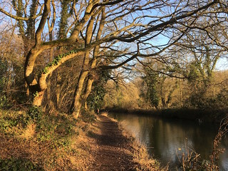
The canal in the afternoon, winter
Hook to Winchfield walk
Jan-17 • Saturdaywalker on Flickr
swcwalks swcwalk84 walkicon banner 32307091920

DSCF2652
Basingstoke Canal from Blacksmith's Bridge
Nov-09 • Sean O'Neill
banner, swcwalk84, swcwalks 5442313812722187970 P

DSCF3009
Winter sunset on the Basingstoke Canal
Dec-09 • Sean O'Neill
swcwalk84, swcwalks, walkicon 5442314329425174370 P

1004170013
Exploring Odiham Castle
Apr-10 • Sean O'Neill
swcwalk84, swcwalks, walkicon 5461416545837198674 P

DSCF8774
The Hunting Lodge, Odiham Common
Jul-11 • Sean O'Neill
swcwalk84, swcwalks, walkicon 5628091398180075906 P


DSCF2630
Basingstoke Canal near Sandy Hill Bridge
Nov-09 • Sean O'Neill
swcwalk84, swcwalks 5442313358669999058 P
| Length |
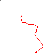
Main Walk: 20 km (12.4 miles). Four hours 30 minutes walking time. For the whole excursion including trains, sights and meals, allow at least 9½ hours. Short Walk, omitting Dogmersfield Park: 16¼ km (10.1 miles). Three hours 35 minutes walking time. Long Walk, extended via Dogmersfield: 24¼ km (15.1 miles). Five hours 30 minutes walking time. Circular Walk, starting from Winchfield: 13¾ km (8.5 miles). Three hours walking time. |
|---|---|
| OS Map |
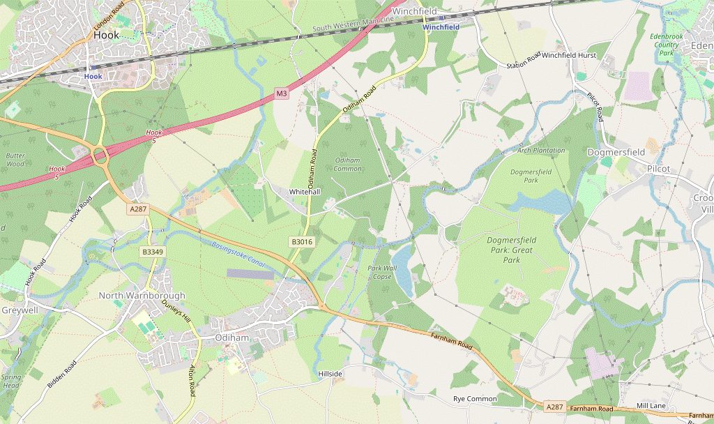
Explorer 144. Hook, map reference SU725540, is in Hampshire, 9 km E of Basingstoke. |
| Toughness |
3 out of 10 (4 for the Long Walk, 2 for the shorter walks). |
| Features |
The start of this walk is affected by Hook's proximity to the noisy M3, but after crossing it on the edge of Bartley Heath nature reserve the motorway is soon out of earshot. The walk then alternates between stretches alongside the River Whitewater and the Basingstoke Canal, with the weatherbeaten ruins of Odiham Castle at their intersection. After passing through the attractive village of Greywell with its ancient church and mill the route doubles back to a lunch stop in the elegant town of Odiham, with its wide Georgian-fronted High Street. In the afternoon the walk rejoins the canal at Odiham Wharf and continues along the towpath to Broad Oak Bridge, where there is a choice of routes (see Walk Options below). The Main Walk goes through the extensive Dogmersfield Park estate (once a royal hunting ground) and past Tundry Pond to rejoin the canal at Blacksmith's Bridge. It then heads back along the towpath before going across fields and along country lanes to Winchfield station. In 2013 there was a major landslip on the canal near Dogmersfield and that section of the towpath was closed for several years. In its latest guise §G is only used by the Main Walk, but as all of this walk's options include substantial sections along the towpath it would be worth checking this Closures and works page or calling the Basingstoke Canal Authority on 01252-370073. |
| Walk Options |
The walk directions include an optional short cut in the morning, which saves 1¼ km by cutting out the loop to Greywell Mill. There are more substantial variations after lunch. At Broad Oak Bridge you could remain on the canal towpath, omitting the section through Dogmersfield Park. This Short Walk saves nearly 4 km and has the added attraction of going past a picturesque Hunting Lodge on the edge of Odiham Common. The remaining two walk options (one long, one short) extend the original walk eastwards from Blacksmith's Bridge. The Long Walk adds 4¼ km by continuing along a rural stretch of the canal to Crookham Wharf and then returning through the village of Dogmersfield. The (short) Circular Walk cuts out the whole morning section (and hence many of the features described above) by starting from Winchfield and joining the Long Walk at Tundry Pond. |
| Additional Notes |
In 2018 the morning route was substantially changed as the paths across Hook Common had become increasingly difficult to follow. The original route had the historically interesting feature of passing both ends of the Greywell Tunnel, but the derelict section of canal was at best “worth seeing, but not worth going to see” (as Dr Johnson famously said of the Giant's Causeway). The route across Bartley Heath makes a better start and the new sections alongside the River Whitewater are a worthwhile improvement. The original Circular Walk was never popular as the only pub lunch options were awkwardly placed: coming either too soon or too late, or requiring a long out-and-back detour along the canal towpath. The new route via Dogmersfield provides some better-placed options and makes a decent enough short walk. |
| Transport |
Hook and Winchfield are adjacent stations on the main line between Basingstoke and Woking. They have a half-hourly service (hourly on Sundays) from Waterloo, taking about 1 hour. Unless you are doing the Circular Walk, buy a return to Hook. If you want to abandon the walk at Odiham, Stagecoach 13 runs hourly (Mon–Sat) along the B3349 at the western end of the town, to Hook station. If driving, park in Winchfield and take the train to Hook (unless doing the Circular Walk). Its large station car park costs £6.60 before noon Mon–Fri, £3.30 at other times (2023). |
| Suggested Train |
Take the train nearest to 09:45 from Waterloo to Hook. You could start half an hour later for the Circular Walk. |
| Train Times |
|
| Timetables |
|
| Lunch |
On the Main Walk there are two places in the first 3 km where you could make an early refreshment stop: Newlyns Farm Shop & Café (01256-704128) at Lodge Farm, closely followed by the Mill House pub (01256-702953) in North Warnborough. In a further 2 km the route passes another possible early lunch pub, the Fox & Goose (01256-702062) in Greywell. However, the most convenient location to break for lunch is Odiham, after 9¼ km. A pub on the square by the church has closed (The Bell), but there are several inns, restaurants and coffee shops in and around the nearby High Street. In the former George Hotel the up-market Bel & the Dragon (01256-702696) serves good if pricey food to 3pm (later on Sundays); next door the refurbished Red Lion (01256-701145) serves food to 2.30pm (all day weekends). There are also several cafés nearby, including Fountains Coffee Shop (01256-701991; closed Sun) and La Crêperie (01256-541720; closed Sun & Mon). Ten minutes further on the walk route passes The Waterwitch (01256-702778), a Chef & Brewer pub which serves food all day. On the Circular Walk there are two pubs on the new eastern section of the walk, both with beer gardens. At Crookham Wharf the Exchequer (01252-615336) “Country Pub and Dining” establishment serves food to 2.30pm (all day Fri–Sun). A little further on in Dogmersfield the Queens Head (01252-622516) is a more traditional village pub, serving food to 2.30pm (later on Sundays). On all but the Short Walk a very late option might be the Barley Mow (01252-617490; closed Mon & Tue) in Winchfield Hurst, but this is only 3¼ km from the end of the walk and has limited food serving times. |
| Tea |
The Barley Mow (see above) is a possible mid-afternoon refreshment stop at weekends, but is likely to be closed on weekdays. At the end of the walk the Winchfield Inn (01252-842129) is close to the station and has a large beer garden. |
| Profile | |
|---|---|
| Help Us! |
After the walk, please leave a comment, it really helps. Thanks! You can also upload photos to the SWC Group on Flickr (upload your photos) and videos to Youtube. This walk's tags are: |
| By Train |
Out (not a train station) Back (not a train station) |
| By Car |
Start RG27 9HS Map Directions Return to the start: Finish RG27 8BX Map Directions Travel to the start: |
| Amazon | |
| Help |
National Rail: 03457 48 49 50 • Traveline (bus times): 0871 200 22 33 (12p/min) • TFL (London) : 0343 222 1234 |
| Version |
Jan-24 Sean |
| Copyright | © Saturday Walkers Club. All Rights Reserved. No commercial use. No copying. No derivatives. Free with attribution for one time non-commercial use only. www.walkingclub.org.uk/site/license.shtml |

Walk Directions
Click the heading below to show/hide the walk route for the selected option(s).


 Walk Map
©
Walk Options ( Main+ )
Click on any option to show only the sections making up that route, or the heading above to show all sections.
- Main Walk (20 km)
Walk Directions
Click on any section heading to switch between detailed directions and an outline, or the heading above to switch all sections.
If you are doing the Circular Walk (from Winchfield), start at §I.
- Hook Station to Hook Road (2¾ km)
- Go out through the supermarket car park and turn left onto Station Road. Keep left at the roundabout and cross over the B3349. Take the left-hand of two footpaths onto Bartley Heath and follow it across the common for 750m. Turn right onto a bridleway leading to a pedestrian footbridge over the M3. On the far side take the footpath heading south-west, then turn left onto a footpath leading to Lodge Farm. Turn right and follow the footpath beside the River Whitewater, passing under the A287 to reach Hook Road (the B3349).
-
Arriving from London, the shortest route out of the station is through an exit at the London end of the short platform canopy. Veer right through the supermarket car park and turn left onto Station Road.
- If this useful short cut is closed, you will have to go over the station footbridge and exit on the other side. Turn left onto a tarmac path and go up a flight of steps to Station Road. Turn left again to cross back over the railway.
- Go along Station Road for 250m, to a roundabout. Follow the pavement round to the left and cross over the B3349 at the designated crossing point. Turn left (briefly heading back towards Hook), then almost immediately go over a stile on the right into the wooded Bartley Heath?.
- Go down a short slope and follow the main path through the trees, initially heading E. As you emerge into a more open part of the heath you will see that the path is going roughly parallel to a line of pylons off to the right. Later it goes through a more wooded area (crossing a ditch on a wooden footbridge), then under another line of pylons.
- The path eventually comes to an unsurfaced track (Holt Lane on the OS map). Turn right and follow the track to a substantial footbridge across the M3, with spiral arms on each side. Cross the motorway and turn right through a metal gate onto a path near the left-hand edge of a wood.
- The next turning is easy to miss. In about 150m, shortly after you have passed a phone mast just outside the wood, fork left onto a narrow path. Leave the wood through a kissing gate and keep ahead on a broad grassy strip between large farm fields, directly underneath power lines and heading SE.
- At the end of the strip keep ahead on a farm track as indicated and continue past the buildings at Lodge Farm. After crossing the River Whitewater follow the track round to the right to head SW, with the river flowing through a meadow off to your right. You soon pass a possible early refreshment stop on your left, Newlyns Farm Shop & Café.
-
At a T-junction keep ahead on a path going under the A287, then back across the river. Go through a gate and follow a grassy path across a meadow, still heading SW. On the far side turn right to go along its edge, with a farm lane on the other side of the boundary fence. In the next corner go over a stile and out onto the B3349 (Hook Road).
- Another (faint) grassy path going diagonally across the meadow implies that some walkers head directly towards this stile.
- Hook Road to Greywell Church (2¼ km)
- Cross the road and follow Mill Lane through North Warnborough Green. After passing a couple of fords turn right onto a footpath leading to the Basingstoke Canal near Odiham Castle. Head south-west on the towpath towards Greywell, going out over the tunnel entrance to Deptford Lane and the Fox & Goose pub. Follow ‘The Street’ through Greywell village to the church.
-
Cross the road carefully. Unless you want to visit the Mill House pub (its entrance is just off to the left) keep ahead on the narrow street opposite (Mill Lane). At the first bend follow it round to the right, then keep left at the next two junctions. Make your way past a cattle grid onto North Warnborough Green?.
The OS map shows an alternative route onto this meadow (a public footpath to the left of “The Cottage” at the first bend), but it was heavily overgrown and all but abandoned when checked.
- Follow this quiet lane alongside the meadow, ignoring footpaths off to both sides. A footway gets you across some branches of the River Whitewater at a couple of fords. Immediately after the second ford turn right through a metal kissing gate onto a signposted footpath.
-
Follow a grassy path straight ahead across a small field. On the far side go out through another gate and turn right onto the towpath of the Basingstoke Canal. In 75m you come to the entrance to Odiham Castle?, which is worth a visit.
There are some information panels behind and inside the ruins about its history (the entrance to its interior is on the right as you go in).
- Return to the canal and turn right to continue along the towpath. After the canal crosses the River Whitewater on a low bridge a large turning circle for narrowboats marks the end of its navigable stretch; the remaining 750m has been been designated as a nature reserve. Towards the end of this stretch the canal briefly narrows, at the site of a former lock?.
- The towpath gradually rises as it approaches the eastern portal of the Greywell Tunnel? (a short zig-zag path leads down to its entrance if you want to risk peering inside without falling in). To continue the walk go over the tunnel entrance and follow a short path round to the right to join Deptford Lane. Turn left at a T-junction in front of the Fox & Goose pub, a possible early lunch stop.
- Follow ‘The Street’ through Greywell village for 350m, with a meadow on the left and some picturesque houses on the right. At the end of the meadow turn left through a lychgate onto a gravel track leading to the small parish church of St Mary the Virgin?.
- Greywell Church to Greywell Moor (1¾ • ½ km)
-
For the full walk take the path through the churchyard into a wood, continuing alongside the River Whitewater to Greywell Mill. Go up to the far end of the mill pond and turn sharp left to return on a bridleway on the other side of the river, through Greywell Moor.
- Alternatively, you can go back through the meadow from the church and cut through the wood on your right, crossing the river on Toll's Bridge.
-
Main route (1¾ km)
- Take the path through the churchyard, past the church tower and into woodland. The footpath soon becomes a long section of boardwalk across the marshy ground, later alongside the River Whitewater and leading to Greywell Mill?.
- Veer left to cross the mill-stream and go past the left-hand side of the attractive old building, as indicated. Continue on the path between a water meadow and its long mill pond, going through a couple of metal gates at the far end.
- Immediately after the second gate turn left onto a signposted bridleway, which goes back along the other side of the water meadow. At the end go through a gate into Greywell Moor and keep ahead along the right-hand side of the (possibly boggy) strip of grassland.
- In 750m go through a metal gate to the right of a fieldgate, with the short cut route joining from the left. Immediately turn right and go through a gate in the hedge.
-
Short cut (½ km)
- Go through a wooden kissing gate into the meadow and follow a grassy path across it, with a wood on your right and The Street away to your left. In 150m go over a stile in a wire fence across the meadow and veer right onto a faint path leading to a stile on the edge of the wood.
- Go over the stile and follow a woodland path through the trees, soon crossing the River Whitewater on “Toll's Bridge”. Leave the wood through a gate and keep ahead across the small Wallace Memorial Reserve? (part of Greywell Moor). On the far side go out through a gate in the hedge ahead.
- Greywell Moor to Odiham (2½ km)
-
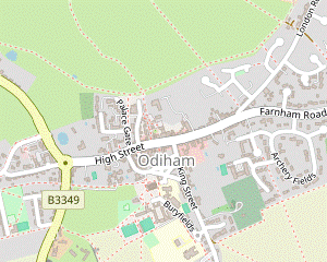 Take the footpath heading east across a large field to Bidden Road. Continue across smaller fields to meet West Street by Robert May's School (or take a zig-zag route on lanes if you prefer). Turn left onto West Street and then right into Recreation Road. Cut across a recreation ground and go along a short residential street to meet the B3349 near the entrance to Chalk Pit Farm. Continue on a footpath through a copse and along a field edge to a sports club. Veer left into the parish churchyard, going down past the historic Pest House and All Saints church into a small square. Take one of the alleyways opposite leading to Odiham's High Street.
- Follow a clear path slightly to the left across a large field, climbing gently and heading E. On the far side go through a gap in the hedge onto a lane (Bidden Road). Cross the lane, go up the bank and turn left along the edge of a field. In the corner bear right and go through a gap in the hedge with a footpath waymarker.
- Take the fenced path between two paddocks as indicated, then continue in the same direction across the next field. Go through a gap in the tree boundary, across West Street and over a stile in the hedge into another large field.
- Turn half-right to continue in much the same direction as before (with no path on the ground, but passing a small tree in the field), aiming for a point about 75m to the left of the far corner. Go over a stile in the hedge here and turn right onto a narrow enclosed path leading back to West Street, which has curved round to the left.
-
Turn left and go along this road for 300m, past a school and round a right-hand bend. Ignore Salmons Road but turn right into the next street, Recreation Road. This soon comes to a recreation ground and you turn half-left to go diagonally across it on a faint grassy path, aiming for an exit about a third of the way up the far side.
- The signposted footpath on the left is a more direct route to Odiham church (500m away), but misses out some interesing features. If you take this short cut, resume the directions at [?].
-
For the suggested route, go out of the recreation ground onto a residential street (Crownfields) and almost immediately turn right. Follow this branch of the street uphill and round to the left at the top.
- Cross the B3349 carefully and take the signposted footpath opposite up through a copse, where there are glimpses of a huge Chalk Pit? on the right. On leaving the wood fork left to continue along the edge of scrubland.
- In 100m fork left again, going through a gap in the hedge and alongside some tennis courts. Turn left at a path crossing, then veer right across a patch of grass. As you enter Odiham's churchyard, the tiny house on your right is a 17thC Pest House?, with a group of Almshouses? beyond it.
-
Follow the path down past All Saints church? into a small square, with an information panel about “Historic Odiham” and a closed pub (The Bell) opposite. Turn right and go past the left-hand side of the attractive “Little Court” house at the end of the square, then turn left down an alley. This comes out onto Odiham's High Street? directly opposite two pubs, the Red Lion and Bel & the Dragon.
- Odiham to Broad Oak Bridge (2 km)
-
For the main route, go through the car park behind Bel & the Dragon on Odiham's High Street. At the far end veer left onto a footpath leading out to a large meadow and turn right to go along its edge. In just over 500m turn right onto a footpath (the driveway to Mayfield House) and turn left onto London Road.
- Alternatively, simply head east along the High Street and bear left into London Road.
-
Main route
- For the main route go down the driveway to the right of Bel & the Dragon, signposted as a footpath. At the back of its car park veer left through a wooden trellis gate with a yellow waymarker onto a narrow enclosed path.
- At the end go out through a kissing gate into a large meadow?. Turn right and follow a faint grassy path near its edge, soon going through a potentially muddy gap in a hedge and then another 350m later.
- In a further 125m the path comes to a kissing gate in front of Mayfield House. Go through this and bear right to go down its driveway. At the end turn left onto London Road.
-
Road route
- For the alternative route turn left out of either of the pubs to head E along Odiham's attractive High Street. In 300m bear left into London Road. The main route rejoins from the driveway to Mayfield House in a further 400m.
- In 150m you pass The Waterwitch pub on the left, the last of the possble lunch places. Cross the Basingstoke Canal on Colt Hill Bridge and turn right on the far side to go down to Odiham Wharf. Head E along the towpath with the canal on your right, ignoring paths leading into a car park.
- The canal swings round to the left and goes under Odiham's bypass, the A287. In a further 500m ignore a footpath on the left and follow the towpath round to the right to come to Broad Oak Bridge.
- Broad Oak Bridge to Blacksmith's Bridge (3¾ km)
- Cross over the canal on Broad Oak Bridge and go through the hamlet of Broad Oak. Turn left onto a footpath across Broad Oak Common and then a meadow to reach a wood. Turn right just inside the wood and follow the footpath almost to the A287. Turn left onto a driveway and head north-east on this right of way through the Dogmersfield Park estate for 2 km, to Tundry Pond. Turn right to go alongside the lake and follow the footpath around the side of a wood to Blacksmith's Bridge.
- Immediately after going under Broad Oak Bridge, turn sharp left up the bank and turn left again at the top, crossing over the canal. Keep ahead on a lane through the hamlet of Broad Oak for 250m, to reach a ‘Community Noticeboard’ about Broad Oak Common on the left.
- Turn left onto a track across the common, signposted as a public footpath. On the far side keep ahead on a fenced path between the entrances to two houses. Cross a wooden footbridge over a stream and continue across a meadow, alongside a new wooden fence.
- On the far side go over a stile and a footbridge onto a woodland path. Almost immediately this comes to a T-junction where you turn right. Follow this footpath for 400m, never far from the meadow off to your right.
- The path eventually goes alongside a tall hedge and comes out onto a gravel driveway, with the A287 just off to the right. Turn left onto the driveway and go between lodges into the Dogmersfield Park estate, heading NE.
- You will be following this right of way through the estate for 2 km, to Tundry Pond. In 450m keep right where the driveway bends left through gates, past the end of Dogmersfield Lake. Follow this track between fences and then gently uphill along the edge of a copse.
-
At the end of the trees go through an old kissing gate to the right of an estate gate. Keep ahead as indicated across a small patch of grass onto the continuation of the footpath, a long grassy path between fences.
The right of way through the Dogmersfield estate has been diverted; it is shown on old OS maps as going along the estate drive to the left, past farm buildings.
- As you go over the brow of a low hill and descend on the fenced path you can see Dogmersfield Park? mansion, 600m away to the right. The path eventually meets the estate drive by some gates and a cattle grid.
- Go across the drive and turn right to continue downhill on the fenced path, directly towards Tundry Pond?. The path ends at a junction of two more estate driveways, where you turn half-left onto the one heading towards the lake.
- At the end of this short drive go through a kissing gate to the left of a fieldgate and veer right onto a grassy path alongside the lake. On the far side follow the path round to the right, passing one of the anti-tank cylinders? in front of a metal fence (with more in the trees behind it). Go over a stile by a white-painted gate and up a slope onto Blacksmith's Bridge, crossing over the canal.
- Blacksmith's Bridge to Stacey's Bridge direct (2¾ km)
- Turn left onto the towpath and follow it all the way to Stacey's Bridge, with a pub off to the right at Barley Mow Bridge if you want to break for refreshment.
- Turn left to go down to the towpath, initially heading N with the canal on your left. After passing Tundry Pond you can see the tower of Dogmersfield's All Saints church? over to your right, beyond the parkland belonging to Dower House? on the hillside ahead.
- The canal goes through a section damaged by a landslip and enters a more wooded area. It gradually curves round to the left and after 1¾ km you are heading W as you approach Barley Mow Bridge. Unless you want to visit the Barley Mow pub (which might not be open), continue along the towpath under the bridge.
-
Detour to the Barley Mow (+150m)
- Veer right through a car park and turn right onto Sprat's Hatch Lane to reach a road junction, with the pub directly opposite. After visiting the pub, cross back over the road with great care (there is limited visibility in this direction). To rejoin the towpath, either retrace your steps through the car park or go up Sprat's Hatch Lane and turn right onto a path going down to it.
- Head W along the towpath, with the canal on your left. In 400m a footpath on the right offers a slightly shorter route to Winchfield church, but it can be muddy and the suggested route is to remain on the towpath for a further 500m.
- Shortly after passing the attractive Old Thatch Cottage? (with a bronze horse sculpture “Venetia” in the garden) on the opposite bank you come to Stacey's Bridge. Go up a short flight of steps and turn right at the top, away from the canal.
- Broad Oak Bridge to Stacey's Bridge direct (2¾ km)
- Head east along the towpath for 250m, where the suggested route is to detour around Wilk's Water to see the Hunting Lodge. Rejoin the canal and continue along the towpath for a further 2¼ km, passing under Sandy Hill Bridge, Sprat's Hatch Bridge, Baseley's Bridge and Stacey's Bridge. Leave the towpath at this last bridge.
- Continue along the towpath for 250m, where the path splits by an information panel about Odiham Common and the Hunting Lodge. You could simply continue beside the canal, but for an interesting diversion fork left. After passing Wilk's Water veer left across the grass in order to see the (privately-owned) Hunting Lodge? over a small white garden gate.
- For a shorter route back to the canal you can take the path between the garden of a house? and the pond, although you have to scramble over a small wooded bank to rejoin the towpath. Turn left to continue along the towpath.
-
In the next 2¼ km you pass the coppiced woodland of Lousey Moor opposite a mooring point for narrowboats on the Dogmersfield Park estate, followed by a series of bridges: Sandy Hill Bridge, Sprat's Hatch Bridge, Baseley's Bridge and Stacey's Bridge.
- As a small respite from this long canalside section you could leave the towpath at the first bridge and rejoin it at the second, 150m ahead: there is a public footpath high up on the opposite bank, through a chestnut coppice.
- Immediately after going under Stacey's Bridge, turn sharp left up a short flight of steps and turn right at the top, away from the canal.
- Winchfield Station to Baseley's Bridge (2½ km)
- Leave the station via an exit on the westbound platform and turn right onto Beauclerk Green. Follow this out to the B3016 and turn left. In 350m turn left onto a footpath heading east and then south-east along field edges to Bagwell Lane. Head south along this lane for 300m, then turn left onto a footpath going around a field and then along a track to Baseley's Bridge. Go down to the towpath alongside the Basingstoke Canal.
- Arriving from London, leave the station via an exit near the bottom of the footbridge. Go past a small car park to a T-junction with a minor road (Beauclerk Green) and turn right. Follow this out to the B3016 and turn left, towards Odiham (take care as there is only a narrow grass verge and the traffic is quite fast).
- In about 350m you go past the entrance to a Pet Crematorium, then turn left onto a signposted footpath. Go through a metal kissing gate to the right of a fieldgate and continue along the right-hand field edge. Ignore a fieldgate ahead and veer right through a kissing gate in the corner to go along the left-hand edge of a large field, now heading S.
- In 400m, where there is a break in the deep ditch on your left, turn left at a footpath signpost and go past the left-hand side of a house. Go over a stile at the end of a short wooden fence and turn right across a small patch of grass to meet a lane at a sharp bend. Bear right and head S on this lane for 300m, with a right-hand bend halfway along.
- At a gap in the trees turn left onto a signposted footpath, going through a side gate to the right of a double metal fieldgate. Follow a short grassy track into a large field and turn left onto the broad field margin. This grassy path soon turns half-right to cut across a corner and continues along the left-hand field edge, parallel to the driveway to the “Old Rectory” which comes into view ahead on the left.
- Shortly after the driveway has veered off to the left, and well before the field corner, veer left through a gap in the hedge to continue on a track on the other side, away from a new wooden fieldgate. Follow this for 200m, past the grounds of the house and through a wooded area to reach Baseley's Bridge over the Basingstoke Canal. Do not cross it but go down a short slope on the left to the towpath.
- Baseley's Bridge to Blacksmith's Bridge (2 km)
- Turn sharp right to pass under the bridge and follow the towpath to Sprat's Hatch Bridge. Cross over the canal and take an enclosed path heading south-east away from the canal to Sprat's Hatch Farm. Turn right onto a footpath through the Dogmersfield Park estate to Tundry Pond. Go alongside the lake and follow the footpath around the side of a wood to Blacksmith's Bridge.
- Turn sharp right to pass under the bridge and follow the towpath to the next bridge (Sprat's Hatch Bridge). Shortly before reaching it fork right up the bank and turn left at the top, crossing over the canal. Continue on an enclosed grassy path, soon with a distant view of Dogmersfield Park? mansion ahead on your right, just over 1 km away.
- At Sprat's Hatch Farm follow its driveway round to the left. Shortly afterwards turn right as indicated through a metal kissing gate, to the left of entrance gates to the Dogmersfield Park estate. Follow the enclosed path between fields and keep ahead where this joins an estate driveway. In 300m turn left at a T-junction towards Tundry Pond?.
- …
- Blacksmith's Bridge to Dogmersfield (village) (4¼ km)
- Turn right onto the towpath and follow it for over 2½ km, to Crookham Wharf at Chequers Bridge. Turn left onto Crondall Road and head north along it for 600m, passing the Exchequer pub along the way. Take the second footpath on the left, heading north-west across fields to Brook Meadow Farm. Turn left onto Pilcot Road to come to the Queens Head pub in the village of Dogmersfield.
- Turn right to go down to the towpath, initially heading S with the canal on your right. In 350m you go under a road bridge and remain on the towpath for a further 2¼ km. At first there are a few houses opposite but the rest of this stretch is completely rural, mostly through woodland.
- Shortly before reaching a road bridge fork left off the towpath. Go through the small car park at Crookham Wharf and turn left onto Crondall Road, heading N. In 200m you pass the Exchequer pub on the right, the first of the possible lunch stops on the Circular Walk.
- To resume the walk continue along the road, taking care as there is no pavement for much of the way. Ignore a signposted footpath along Stroud Lane after 200m, but in a further 200m turn left at another footpath signpost (opposite Brook House). A little way back from the road, go through a wooden kissing gate to the left of a farm track onto a grassy footpath between wooden fences.
- At the end of the fence on the left go over a stile and keep ahead across a field towards some old farm buildings. In the far right-hand corner go over an old stile and bear right as indicated. Follow a track past the buildings and out onto Pilcot Road.
- Turn left to head W into the village of Dogmersfield. After crossing the River Hart on Pilcot Bridge you come to another possible refreshment stop in the triangle of roads ahead, the Queens Head pub.
- Dogmersfield to Stacey's Bridge (2¾ km)
- Head north from the pub and go across Chatter Alley onto a cul-de-sac leading to Pilcot Farm. Continue on a footpath heading north and then west across fields and between paddocks to Pale Lane. Turn left onto the road to come to the Barley Mow pub in Winchfield Hurst. Cross the road in front of the pub onto Sprat's Hatch Lane. At Barley Mow Bridge turn right onto the canal towpath and follow it to Stacey's Bridge.
- Head N from the pub and go straight across the main road (now Chatter Alley) onto a cul-de-sac past an attractive cottage (Lords and Ladies). After passing a small thatched barn follow the drive briefly round to the left, then turn right through a wooden kissing gate with a footpath waymarker. Go alongside a fence to a farm track, with a line of trees ahead separating two fields.
-
Go across the track (slightly to the right) and through a wooden fieldgate with a footpath waymarker to continue along the edge of the right-hand field, with the tree boundary on your left. At the far end veer left past an old metal fieldgate and turn half-right onto the second of two broad grassy paths off to the right, through a copse.
A yellow waymarker on a tree confirms that this is the right of way, although it appears that many walkers take the first path: the two rejoin on the far side of the copse.
- At the end bear right into a large field and turn left to go around its edge on a wide grassy margin, initially heading W but soon turning right at a corner with a footpath signpost. Follow the field edge round to the left and then veer left onto a broad grassy track through a long narrow wood, heading W again.
- In 250m the track merges with another grassy track coming in from the right. Continue along a narrow path through a belt of trees, with Hungerford Solar Farm in the field on your right. In 150m keep ahead over an old stile, ignoring another footpath off to the left.
- At the end of the wood continue on a long grassy track between paddocks, passing through a few metal kissing gates along the way. At the far end turn left onto a minor road (Pale Lane), in 200m coming to the Barley Mow pub (a possible refreshment stop, if open).
- To continue the walk, cross the road in front of the pub with great care (there is limited visibility) into Sprats Hatch Lane opposite, which goes up a short incline onto Barley Mow Bridge. You can either go up the slope and turn right to go down to the towpath, or nip through the car park on the left and turn right onto it, passing under the bridge.
- …
- …
- Stacey's Bridge to Winchfield Station (2¼ km)
-
Head north-west across a meadow, through Hellet's Copse and along a field edge to Winchfield church. Go through the churchyard and out along its driveway to a lane. The suggested route is to turn right and head north along quiet country lanes, passing the Winchfield Inn just before the station.
- Alternatively, you can reverse the Circular Walk's start by heading north-west along field edges to the B3016, then taking this road and Beauclerk Green to the station.
- Go through a metal kissing gate gate and follow a grassy path across a meadow towards a wood, heading NW. Go through a squeeze gate onto a broad path through Hellet's Copse. At the far end go straight across a wide gap via two more squeeze gates and through a belt of trees into the corner of a field.
- Keep ahead along the left-hand field edge. In the next corner go through a wooden gate to enter the churchyard of St Mary the Virgin? (which is worth visiting if open). Continue through the churchyard and along a short driveway to come to a lane at a bend.
-
Main route
- Turn right onto the lane to head N. In 500m turn left at a T-junction. In a further 700m the lane passes under the railway and turns sharply left. The Winchfield Inn is on the right in 200m, with the entrance to the station's main car park a little further along the road. Trains to London leave from Platform 1, on the near side.
-
Alternative route
- Continue in the same direction along the lane for 150m. Where it turns sharply left veer right across a small patch of grass to a footpath signpost at the end of a wooden fence. Go past the right-hand side of a house and its garden towards a redundant stile at the top of a low bank. Go past it and turn right to walk along the edge of a large field.
- In the field corner go through a metal kissing gate into another field and turn left to head W along its edge. In the next corner go out via another kissing gate and turn right onto the B3016 (take care as there is only a narrow grass verge and the traffic is quite fast).
-
In 350m turn right into a winding cul-de-sac, Beauclerk Green. As you approach some new houses turn left past a small car park to reach the station. Cross the footbridge to Platform 1 for trains to London.
- If you want some refreshment, go through the main car park and turn right onto the road. The Winchfield Inn is on the left in about 100m.
- Bartley Heath, North Warnborough Green and Hook Common (just off the route) are all managed by the Hampshire & IoW Wildlife Trust, which has introduced grazing by Exmoor ponies and Highland cattle to re-establish habitats lost when the area was sliced in two by the M3.
- Odiham Castle was built by King John in the early 13thC as a stopover between the royal towns of Winchester and Windsor. It was his base during the negotiations at Runnymede which led to Magna Carta.
- This lock had a fall of only 1ft (30cm), but raised the water level in the tunnel to help with navigation through it.
- Greywell Tunnel has no towpath so boats had to be ‘legged’ through it, taking up to six hours. The tunnel collapsed in 1932 but was never repaired since commercial traffic to Basingstoke had already ceased. It is now home to one of the UK's largest bat roosts.
- St Mary the Virgin, Greywell dates from the end of the 12thC, with a fine Norman doorway; the carvings of crosses in the stonework around it are thought to have been made by men going off to fight in the Crusades.
- Greywell Mill is mentioned in the Domesday book, but the present building dates from around 1600. It is reputed to have been working as a flour mill until the mid-1930s.
- The Wallace Memorial Reserve is dedicated to an eminent botanist, EC Wallace, as shown on a memorial stone to the right of the path.
- Odiham's Chalk Pit (a disused quarry) was used to intern Napoleonic prisoners of war and later to tether airships during 20thC wars. The private owners occasionally allow the area to be used as a venue for jazz concerts and the like.
- Odiham's Pest House was built in 1622 to quarantine local people and travellers with the plague and other infectious diseases. One of just five or six surviving isolation houses, it is open to visitors at weekends.
- The original Almshouses were founded in 1623 by Sir Edward More. Their modern replacements are still in use as such.
- Most of All Saints, Odiham dates from the 12thC, but has been extensively modified and enlarged over the centuries. It is built in flint with a rather incongruous Tudor brick tower, hemmed in by two large aisles.
- Odiham's wide High Street contains many elegant Georgian-fronted properties (some are just façades for older buildings). The town used to have a brewery and the hops for it were grown locally, hence the presence of several converted oast houses.
- The meadow to the north of Odiham used to be a royal deer park.
- The Georgian mansion of Dogmersfield Park was built in 1728. It suffered major damage in a fire in 1981. Since 2005 it has been the Four Seasons Hotel Hampshire.
- Tundry Pond was created in the 18thC by the owner of Dogmersfield Park, who wanted a lake view. Some houses on the site were reconstructed in the nearby hamlet of Pilcot, which became the new village of Dogmersfield (‘the field by the lake where the water lilies grow’).
- The anti-tank cylinders are reinforced concrete fortifications which were part of a defensive line constructed around London in World War Ⅱ. There are others as well as the more familiar pillboxes in the 2½ km stretch between Blacksmith's Bridge and Crookham Wharf.
- All Saints, Dogmersfield was built in 1843, after the reconstruction of the village around the hamlet of Pilcot.
- Dower House was the home provided for a widow on the Dogmersfield Park estate.
- Old Thatch Cottage dates from the mid-17thC (ie. before the canal). Its garden is open to the public on NGS Open Days.
- The Hunting Lodge on the edge of Odiham Common is a cottage orné (an ornately designed small country home, in rustic style). Built in the 1730s, the striking pseudo-Jacobean façade of this (otherwise very plain) gamekeeper's house was designed to be seen from Dogmersfield Park.
- The eponymous house at Wilk's Water was converted from two gamekeeper's cottages by the Redgrave theatrical family in 1956, and used by them as a country retreat.
- St Mary the Virgin, Winchfield dates from 1150. It has a particularly fine chancel arch with Norman ornamentation, but unfortunately the church is usually locked.
The short cut in [?] bypasses an attractive riverside stretch out to the mill pond at Greywell Mill, but it also avoids the return leg through Greywell Moor which can be boggy.
The main route has two short stretches which can be very muddy, so in winter you might prefer to take the road route in [?].
If you are doing the Short Walk, go to §H.
If you are doing the Long Walk, go to §K.
Complete the directions at §M.
Complete the directions at §M.
There is a choice of routes to Winchfield station. The main route is along quiet country lanes and passes the Winchfield Inn just before the station. The alternative route in [?] is the reverse of the start of the Circular Walk; it has less road walking but the B3016 has more traffic.
Walk Notes
» Last updated: January 2, 2024
Return to Top | Walk Map | Walk Options | Walk Directions.