Hope to Hathersage or Bamford (via Castleton) walk
Pastures with views, Mam Tor's landslip area, Cave Dale, lunch in Castleton, Hope Cement Works, a large upland moor and a scenic descent to the Derwent River
Hope Cement Works and Bradwell Edge
SWC Walk 343 - Hope to Hathersage or Bamford (via Castleton)
Jul-19 • thomasgrabow on Flickr
banner swcwalks swcwalk343 48204653396

Peveril Castle, Cave Dale & Peak Cavern
SWC Walk 343 - Hope to Hathersage or Bamford (via Castleton)
Jul-19 • thomasgrabow on Flickr
walkicon swcwalks swcwalk343 48204652996

Road through Mam Tor Landslip Area
SWC Walk 343 - Hope to Hathersage or Bamford (via Castleton)
Jul-19 • thomasgrabow on Flickr
walkicon swcwalks swcwalk343 48204650121

Winnats, from near Winnats Head Farm
SWC Walk 343 - Hope to Hathersage or Bamford (via Castleton)
Jul-19 • thomasgrabow on Flickr
walkicon swcwalks swcwalk343 48204648276

View down Cave Dale (Peveril Castle and Lose Hill)
SWC Walk 343 - Hope to Hathersage or Bamford (via Castleton)
Jul-19 • thomasgrabow on Flickr
walkicon swcwalks swcwalk343 48204694642

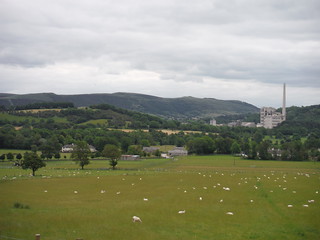
Hope Cement Works, The Great Ridge and Kinder Scout, from near Rebellion Knoll
SWC Walk 343 - Hope to Hathersage or Bamford (via Castleton)
Jul-19 • thomasgrabow on Flickr
walkicon swcwalks swcwalk343 48204637376
Over Dale, Win Hill and Crookstone Knoll (Kinder Scout)
SWC Walk 343 - Hope to Hathersage or Bamford (via Castleton)
Jul-19 • thomasgrabow on Flickr
walkicon swcwalks swcwalk343 48204636361
| Length |
27.0 km (16.8 mi), with 728/742m ascent/descent. For a shorter or longer walk see below Walk Options. |
|---|---|
| Toughness |
8 out of 10, with 7 hours walking time. For the whole outing, including trains, sights and meals, allow at least 13 ½ hours. |
| Walk Notes |
This route at the top of the scenic Hope Valley starts with a gentle loop through pastures between the Peak District's breath-taking limestone and gritstone landscapes with ever-changing views to the hills around. You head for the mysterious Mam Tor, before ascending its flank through the large landsliped area at its foot. A variation leads to the dramatic limestone gorge of Winnats Pass and past a couple of the show caves Castleton is famous for. A high-level traverse of pastures-with-views loops down to Castleton through the fascinating Cave Dale (a collapsed cave), past the Norman Castle ruins towering above it.
Note: To protect ground nesting birds, only dogs kept “…under effective control on Public Rights of Way” are allowed on the Access Land of Abney Moor/Smelting Hill/Offerton Moor, until at least 04/2022. |
| Walk Options |
A late starter might want to – after 4.6 km – follow Hollowford Road for 300m into Castleton for lunch first, before continuing the route (see route map and text).
|
| Maps |
OS Explorer: OL1 (The Peak District – Dark Peak Area)
|
| Travel |
Hope Station, map reference SK 180 832, is 18 km south west of Sheffield, 231 km north west of Charing Cross and 169m above sea level. Bamford Station, map reference SK 207 825, is 3 km south east of Hope Station and 151m above sea level. Hathersage station, map reference SK 232 810, is 3 km south east of Bamford Station and 163m above sea level. All are in Derbyshire. The stations are on the Hope Valley Line from Manchester to Sheffield, with a journey time of 19 to 26 mins from/to Sheffield. Sheffield is the terminus of the Midland Main Line from London St. Pancras, with up to two trains per hour (journey time from 118 mins Mon-Sat, longer on Sundays). Saturday Walkers’ Club: Take a train no later than 9.00 hours. |
| Lunch |
In Castleton (13.4 km/8.3 mi to 14.1 km/8.7 mi from the start):
In Bradwell (16.6 km/10.3 mi to 17.6 km/10.9 mi from the start):
|
| Tea |
In Hathersage:
In Bamford:
|
| Profile | |
|---|---|
| Help Us! |
After the walk, please leave a comment, it really helps. Thanks! You can also upload photos to the SWC Group on Flickr (upload your photos) and videos to Youtube. This walk's tags are: |
| By Train |
Out (not a train station) Back (not a train station) |
| By Car |
Start S33 6RD Map Directions Return to the start: Finish S32 1DT Map Directions Travel to the start: |
| Amazon | |
| Help |
National Rail: 03457 48 49 50 • Traveline (bus times): 0871 200 22 33 (12p/min) • TFL (London) : 0343 222 1234 |
| Version |
Apr-24 Thomas G |
| Copyright | © Saturday Walkers Club. All Rights Reserved. No commercial use. No copying. No derivatives. Free with attribution for one time non-commercial use only. www.walkingclub.org.uk/site/license.shtml |

Walk Directions
Full directions for this walk are in a PDF file (link above) which you can print, or download on to a Kindle, tablet, or smartphone.
This is just the introduction. This walk's detailed directions are in a PDF available from wwww.walkingclub.org.uk