Horsley to West Byfleet walk
Green woods and fields, the yellow scrub and heathland of Ockham Common, Wisley Common and RHS Wisley Gardens (public footpath), and a canal side pub on the Wey Navigation
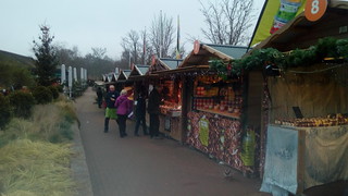
Christmas Market at RHS Gardens Wisley
Dec-16 • quitenearmike on Flickr
swcwalks book3 walk214 31716810555

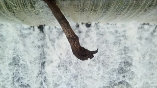
The closed footpath
Closure now extended again until 12th August 2017
Dec-16 • quitenearmike on Flickr
swcwalks book3 walk214 31343758980

Christmas Decorations
Walsham Lock footbridge
Dec-16 • quitenearmike on Flickr
swcwalks book3 walk214 30875140954
Horsley to West Byfleet 19 Dec 21 SWC1
Dec-21 • Steven F Coles on Flickr
swcwalks swcwalk214 51760671591

Horsley to West Byfleet 19 Dec 21 SWC3
Dec-21 • Steven F Coles on Flickr
swcwalks swcwalk214 51760911228
| A3/M25 Jn | [Aug-24] The A3/M25 junction is being re-imagined during roadworks until summer 2025. This will severely disrupt this walk as the A3 bridge the walk uses is being replaced. |
|---|---|
| Length | 15.4 kilometres. |
| OS Maps | Explorer 145 and (only for the last section which is by canal and road) 160. Horsley, map reference TQ092545, and West Byfleet, map reference TQ042611, are both in Surrey. |
| Toughness | 3 out of 10. There are no significant inclines and the only places where navigation needs concentration are on Ockham Common and Wisley Common, either side of the A3. A short section of Wisley Common can be saturated underfoot. |
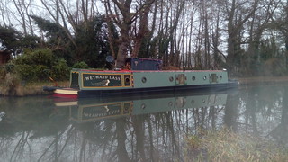
| Features | The walk closely follows a section of Keith Chesterton’s London Countryway route (see points of interest below). It begins with a section of ‘B’ road but then follows paths through woods and across fields to the hamlet of May’s Green. The landscape then dramatically changes from green to yellow with the open sandy scrub and heathland of Ockham Common, almost Mediterranean on a summer’s day. There is the option of a short detour to Chatley Semaphore Tower. West of the A3, the walk crosses Wisley Common, which can be very wet, then goes alongside the RHS Wisley Gardens. You briefly follow the River Wey to Ockham Mill - NB An important bridge in this area was closed in 2014/15 and may necessitate a significant detour - before taking the towpath of the Wey navigation past the canal side Anchor pub (ideal for a late lunch). The approach to West Byfleet is on a suburban path and a moderately busy road. |
| Shortening the Walk | The extension to Chatley Semaphore Tower (from Point B) adds 1.4 kms to the distance but if you take the direct route (from Point A) there is negligible difference in distance. From the RHS Wisley Gardens bus stop on the A3 you could catch Abellio bus 515/515A to either Guildford or Kingston (via Esher and Surbiton). From the Anchor you could retrace your steps to Lock Lane and turn right for approximately 800 metres (you will shortly find a path on the left side of the road which will also take you there) for an Arriva 437 bus from Pyrford Green to either Woking or West Byfleet (not on Sundays). The bus stops are to your left when you reach Pyrford Road. It’s probably quicker to complete the walk! |
| Travel | Horsley station is served by South West Trains services from Waterloo to Guildford. Trains take 45 minutes via Cobham and Stoke d’Abernon, or 57 minutes via Epsom. There are normally 4 trains an hour but only 2 on Sundays. Make sure not to get a train which goes via Woking. SWT will also convey you from West Byfleet to Waterloo. There are 4 trains an hour, taking anything from 28 to 48 minutes (it is generally best to catch the first train), except on Sundays when there are 2 trains an hour. There are also trains via Staines but these take much longer. Your best bet is probably to get a day return to Guildford. |
| Points of interest |
London Countryway Like Wainwright’s ‘Coast to Coast’, Keith Chesterton’s ‘London Countryway’ was one man’s brainchild and has never had any official recognition, there is no body charged with maintaining the route and there is no marking either on the ground or on OS maps. Whereas Wainwright’s route has been enhanced and updated over the years, as a result of its popularity, the ‘London Countryway’ has largely been forgotten since the book was last updated in 1981 – mainly to take in to account the route of the proposed M25! Unlike the London Loop or the Capital Ring, the London Countryway is a genuine country walk. Chesterton’s book breaks the walk down in to 22 stages, totalling 196 miles, clockwise from the top of Box Hill. This walk closely follows section 2, except that Chesterton envisaged crossing the A3 at ground level and it would be foolhardy not to use the modern footbridge, so a different route is taken across Ockley Common. The London Countryway largely follows the River Thames from Windsor to Marlow, cuts across the Chilterns to St Alban’s, makes use of the Lee Valley navigation and crosses Epping Forest to reach the Thames again at Tilbury. Resuming at Gravesend, much of the route South of the Thames was later adopted by the Wealdway and the Greensand Way (and by Time Out walks such as Borough Green-Sevenoaks and Sunningdale-Windsor). Recently a website produced by Des DeMoor has updated the walk, beginning at Gravesend. His directions are invaluable, but curiously he appears to have lost interest and abandoned the project at Broxbourne on the River Lee. Chatley Semaphore Tower The 70 foot high semaphore tower is the only surviving example of a line from Portsmouth to Whitehall which were used by the Admiralty to communicate naval instructions before the telegraph. It was built in 1822 and fully restored in 1989. Tours of the interior are available on a handful of dates each year (£3 in 2014) and include the chance to take in the view from the top. Royal Horticultural Society Garden, Wisley The garden was founded in 1878 and gifted to the RHS in 1903. It is now the Society's flagship public garden and a major visitor attraction, and also an important site for testing cultivation techniques and experimenting with new varieties and species. This walk takes a fenced public footpath through tall kissing gates intended to keep out animals, running initially between two sections of the garden. Ockham Mill Built in the Gothic style in 1862, though there has been a mill on this site since c1300. The mill is now private housing. River Wey and Wey navigation |
| Lunch |
The Black Swan, Old Lane, Martyr’s Green, Ockham, Surrey. A possible early lunch option which requires a short detour. Lunch served from 12 to 3pm, later at weekends. Email: enquiries _AT_ blackswanockham.com Ockham Bites This is a café with outdoor seating, suitable for a light lunch, at the car park just before you cross the A3. The Anchor Pyrford Lock, Wisley, Woking, Surrey, with garden on the banks of the river Wey, reached after 12.7 kms. Old furniture, pictures, blackboards and books, flagstones and fires give relaxed and comfortable surroundings. Restaurant open from 11.30am to at least 9pm. Uses regional food partners, typically from family businesses, to create fresh, unpretentious, seasonal dishes. Tel: 01932 342 507, anchor.wisley _AT_ hall-woodhouse.co.uk |
| Tea |
Bell Amico, 16 Station Approach, West Byfleet. Italian coffee bar and restaurant. Open to 5pm Monday to Saturday. Taylor’s Independent Coffee House, 17 Station Approach, West Byfleet. Next door to Bell Amico. There is also a Costa Coffee on Station Approach near West Byfleet station. The Station (pub/restarant), 2 The Station, West Byfleet. |
| Profile | |
|---|---|
| Help Us! |
After the walk, please leave a comment, it really helps. Thanks! You can also upload photos to the SWC Group on Flickr (upload your photos) and videos to Youtube. This walk's tags are: |
| By Train |
Out (not a train station) Back (not a train station) |
| By Car |
Start KT24 6QX Map Directions Return to the start: Finish KT14 6DY Map Directions Travel to the start: |
| Amazon | |
| Help |
National Rail: 03457 48 49 50 • Traveline (bus times): 0871 200 22 33 (12p/min) • TFL (London) : 0343 222 1234 |
| Version |
Sep-24 Mike Powell |
| Copyright | © Saturday Walkers Club. All Rights Reserved. No commercial use. No copying. No derivatives. Free with attribution for one time non-commercial use only. www.walkingclub.org.uk/site/license.shtml |


Walk Directions
- 1 Horsley to May’s Green (4.4 kms)
- Trains from Waterloo arrive on platform 2 at Horsley station. Leave the station and turn right on the forecourt. In 50 metres go down the steps to the right (just to the left of The Stockyard shop). In 40 metres cross the B2039 (Ockham Road North) and turn right on the pavement. In 10metres you go under the rail bridge. In 200 metres ignore a turning on the right (The Highlands). In 100 metres you pass Horsley Evangelical Church opposite and in another 100 metres you pass Glenesk School. In 100 metres opposite East Lane cross back over the road and cut across the grass verge as indicated by a Horsley Jubilee Trail arrow, then turn right on Drift Road. In 50 metres take the signed path to the right (Forest Path), which goes over a stream and past an information board, then runs through woods parallel to the road.
- In 80 metres ignore a fork to the right. In 80 metres turn left at a public footpath sign for the Horsley Jubilee Trail and cross the road. Take the sign-posted footpath opposite (named on the map as Blue Ride), with a wire fence on the right and a narrow strip of trees on the left. The woods to the right are named on a tree as Blue Ryde Lodge Wood. In 200 metres, shortly after the fence turns to the right, you turn right at a yellow arrow on a post on to a narrow uphill path, surrounded by rhododendrons. In 150 metres the path turns to the left (North West). In 800 metres you go over a footbridge and turn right on a track (Whitehill Lane), which goes uphill with a wire fence to the left. In 200 metres the lane bears left but you turn right at a public footpath signpost, through a strip of trees with fields to both sides and a wooden fence on your left. In 500 metres the buildings of Blackmoor Farm are visible to your left behind tennis courts. In 120 metres you cross a private path from the farm. The path turns to the right in 200 metres and to the left in 100 metres.
- In 120 metres you turn right again at a yellow arrow, now in the open at the edge of the woods on your left. In 50 metres turn left, still with the woods to your left and a field to your right. In 80 metres you pass a wooden hay barn and continue in to the woods ahead. In 200 metres you go over a footbridge and continue ahead. In 60 metres, within sight of a stile ahead, fork left off the main path (this avoids having to climb over a gate). In 50 metres you go through a heavy black metal gate. In 15 metres turn left on a drive. In 15 metres turn left on Old Lane by Lake House (GR097565) and cross the road.
- In 200 metres you pass Surrey Poultry Farms and ignore a sign-posted public footpath on the right. (!) In 15 metres leave the road and go past wooden railings leading to the corner of a large field. In 20 metres turn left to follow the left edge of the field, parallel with the road with a hedge on your left (in muddy conditions you may prefer to stay on the road, which is the route taken by the original London Countryway). In 80 metres you will notice a paintball venue across the road. In 400 metres you turn right along a narrow lane at May’s Green.
- 2 May’s Green to Ockham Common (A3) (3.2 kms)
- (!) In 100 metres, take the first path to the left by a telegraph pole, before a wooden signpost which points you towards ‘Ockham Lane ½’. Your path goes over a low stile with a yellow footpath arrow, then half left across a lawn. In 40 metres go over a wooden plank bridge. Continue on a narrow potentially muddy path with tall wooden fences on both sides. You go past a green public footpath sign and over a stile in 150 metres, crossing another path. Continue on a muddy enclosed path, with fences (probably electric) and fields to both sides. In 60 metres you go over another stile with a sign for the Downside Walk.
- In 80 metres you have farm buildings and horse paddocks to both sides and Orchard Farm on your right. Keep ahead along a tarmac farm track, ignoring another tarmac track to the left in 70 metres. When the tarmac turns to the left in 180 metres by a ‘cat hotel’, continue ahead on a marked footpath - a narrow residential path, which can be overgrown in summer, with a wall on your left and a fence on your right. In 80 metres you go through an old metal kissing gate and down a few wooden steps then turn left on Ockham Lane, opposite Hillside Cottage.
- In 100 metres turn right on tarmac at a public bridleway sign reading 2/3 mile to Ockham Common (staying on the road for another 400 metres will take you to the Black Swan at Martyr’s Green, which is to the right at the next road junction – after lunch turn right from the pub and then take the first path on the right, to pick up the main route as below). In 250 metres ignore a footpath to your left (if coming from the Black Swan, turn left here). Visible to your right is Hatchford Park, an 1850s mansion. In 250 metres you pass Oaklands, the first of three houses on the left. The drive turns left in 30 metres but you continue past a wooden barrier and a signpost reading 300 yards to Ockham Common, now on a muddy path. In 100 metres you ignore a path on your right marked by a post indicating the Downside Walk and continue on a muddy path.
- (!) In 40 metres turn left (250 degrees) opposite wooden railings at Point A (but see below at * for the direct route via Chatley Semaphore Tower). In 200 metres the path divides and you fork left, towards the houses. The path twists and turns through a heavily wooded area. In 220 metres go over a sleeper bridge and through a boggy section. In 100 metres you pass between wooden posts to emerge in an open area with a wooden field gate to your left. In 30 metres turn right on a wide track with a house to your left. In 40 metres you pass a pond on your right, with a field on your left.
- In 120 metres continue past a yellow footpath arrow on a post. In 30 metres fork left by a tree with a white arrow (which points right). In 40 metres a wider sandy path merges with you from the right and you continue on the main path (340 degrees at first) across an open almost desert-like landscape.
- In 280 metres you cross a path marked by a distinctive ‘red sailor’ logo (Point B – follow the directions below at ** for the extension via Chatley Semaphore Tower).
- In 140 metres, within sight of seats ahead, fork left off the main path towards the woods. In 150 metres turn left on to a wide path marked by the ‘blue sailor’ logo (Point C – the direct route and the extension via Chatley Semaphore Tower re-join you here)***.
- (!) In 25 metres, just after you enter the woods, fork right (North West) at an unmarked junction on to a narrow path to the right of a tree with a faded number 6 painted on it, away from the car park (where you could detour for refreshments and toilets, though these may be closed). In 50 metres go straight on at a post with a blue permissive horse ride sign. In 200 metres you cross over the A3 footbridge.
- Detours via Chatley Semaphore Tower
- *For the direct route, continue ahead at Point A. In 160 metres go through a wooden barrier with a ‘no horses please’ sign, by a three armed sign-post (Point D – see below).
- **For the extension, turn right at Point B and follow the ‘red sailor’ signs. In 250 metres you cross a path and continue opposite. In 100 metres take the path to the right. In 150 metres turn left just before a wooden barrier and three-armed signpost (Point D – the direct route joins you here).
- In 120 metres from Point D, turn right at another post with a red sailor logo and follow these signs to the Semaphore Tower. You go up some rough steps and in 80 metres you pass another post with both red and blue sailor logos. In another 80 metres you reach the Semaphore Tower. Return to the last post and now follow the blue sailor logos. In 280 metres you pass some benches and continue steadily downhill. You cross a path by more seats in 180 metres and a third set of benches by a small information board at a path crossing in 180 metres. Continue ahead to the next ‘blue sailor’ post in 150 metres (Point C). The main route continues ahead from *** above.
- 3 Wisley Common (A3) to Wisley Gardens (2.0 kms)
- Go through a gate in 100 metres and in 5 metres fork left past an information board then in 25 metres turn left along a wide tarmac and gravel track. In 100 metres turn right at a wooden signpost pointing ahead to Hutt Hill and right to Pond Farm and Birchmere. In 150 metres turn left at a blue permissive horse ride arrow on to a broad sandy track, skirting a wooded hillock (Hut Hill) with a cottage on top and the treeline on your left. In 150 metres the path turns to the left, back towards the A3, and uphill. In 450 metres you cross a stream. In 30 metres pass a wooden post with a permissive horse ride arrow on your left. In 15 metres there is another wooden post with an arrow and you continue ahead, ignoring the path to the right.
- In 50 metres ignore a path to the right and in another 150 metres ignore a path to the left. In 150 metres continue ahead at a cross-paths by a post. In 240 metres the path turns to the right through a muddy area, parallel with the road (North-West). In 200 metres turn left towards a gate (in 2014 there was a metal trough to the right of the path here). In 30 metres turn sharp right before the gate, with a wire fence to your left. In 150 metres go through the next wooden gate on your left, which brings you out to the left of Wren’s Nest car park. In 50 metres turn left on Ockham Lane (GR065588).
- 4 Wisley Gardens to The Anchor, Pyrford Lock (3.1 kms)
- In 50 metres fork right on to a drive (but for a bus to Guildford or Kingston, stay on the road until you reach the main entrance to Wisley Gardens on the A3). In 50 metres fork right again at a two armed wooden signpost, to the left of Oakland Lodge. In 50 metres you go through a tall kissing gate. In 50 metres go through two more kissing gates either side of a drive and continue with a barbed wire fence on both sides (the boundary of Wisley Gardens). In 200 metres you go over a wooden bridge with the River Wey behind the fence to your right and Wisley Golf Course beyond. In 180 metres the path veers left away from the river and soon you pass the striking Glasshouse (opened for the RHS bicentenary in 2007) on your left, behind the wire fence. In 200 metres go through a tall kissing gate and turn left, still beside the fence.
- Cross a drive in 100 metres and take the signed grassy public footpath opposite, going straight ahead (South-West) through an area of scrubland and vegetable plots. In 150 metres you reach the corner of a wooden fence on the right and soon you also have a barbed wire fence on the left. In 300 metres there are houses on the right and greenhouses on the left.
- In 100 metres you turn right (North-West) on Mill Lane, ignoring the path opposite (but note that the next footbridge was closed in early 2014, so you may have to detour this way – the closure order runs until August 2015, but it may be extended). In 80 metres you pass the attractive brick Ockham Mill on your left. In 10 metres take the signed public footpath ahead (Wharf Lane). In 60 metres go through a wooden gate or over a stile and continue with a black metal fence on your right and a golf course beyond. In 500 metres cross a wooden footbridge over the river. In 80 metres turn right to walk along the towpath with the canal to your left (you are now also following the E2 European Long Distance Path which will eventually deposit you in Galway or – if you turn left in error - by the Mediterranean at Nice). In 120 metres ignore a black metal bridge (Pigeon House Bridge).
- In 15 metres ignore a path to the golf course on your right (you can still see the RHS Glasshouse beyond). In 700 metres you pass Pyrford Lock. In 30 metres cross Lock Lane and continue on the towpath. In 40 metres you reach The Anchor on the right.
- 5 The Anchor, Pyrford Lock to West Byfleet (2.7 kms)
- Turn right from The Anchor, following the towpath past the entrance to Pyrford Marina opposite in 150 metres. In 350 metres you go under a line of pylons and you have another golf course opposite (Traditions Golf Course). In 450 metres cross the next bridge (Dodd’s Bridge) which takes you half left, away from the canal on the stony Dodd’s Lane, with a ditch to your left and a barbed wire fence to your right.
- In 200 metres you ignore a path to the golf course over the ditch and Dodd’s Lane turns to the right. In 250 metres the path turns to the left and comes out in a meadow. Ignore the muddy left fork leading to a car park and continue ahead on a stony path towards houses, with a tall barbed wire fence on your right at first. In 300 metres you go through a gap between houses, now on a residential road.
- In 100 metres turn right on Pyrford Road, opposite Hollybank Road. In 100 metres ignore the Oaks, in 200 metres ignore Greenway Close and in 250 metres ignore Highfield Road, all on your right. In 150 metres cross at the traffic lights and continue in to Station Approach.
- You pass the library in 20 metres, Costa Coffee in 50 metres and cross Madeira Road in 50 metres. In another 50 metres you pass Bell Amico and Taylors Independent Coffee House. In 30 metres go through the station subway (if you continue through the subway you will find The Station pub and restaurant).
- Trains for London Waterloo leave from platform 1.