Newhaven to Brighton and Portslade Walk
A Victorian Fort, White Cliffs, cliff top and cliff bottom paths, Brighton's busy pier and promenade and quieter Hove

Smile please!
Clifftop photo opp
Apr-14 • magyardave2002 on Flickr
book3 swcwalks walk213 13929061273

| Length |
11.4 miles ( 18.4 km) with 300 ft (100 meters) of ascent. [*] 14.8 miles ( 23.8 km) if you continue to Portslade. You can also save a km by skipping Newhaven's break water. |
|---|---|
| Toughness | 3 out of 10. Easy going on hard surfaces. No shingle. Wear trainers. |
| OS Maps | OS Explorer OL11 (was 122) (Brighton) |
| Walk Notes |
This coastal walks has a varied mix - a Victorian Fort and harbour arm, quiet White Cliffs, an undercliff path, Brighton's marina, busy promenades and board walks passing Brighton's pier, shops, cafes, and, on sunny days thousands of day trippers. Then its quieter promenade and beach huts, before ending in Portslade. The whole walk has nice sea views, and there are many places to swim. It starts with a short harbourside walk down to the sea. Here you choose between a gentle climb to Castle Hill's (55m) coastwatch station, passing a Victorean Fort, or you can continue to the beach (and optionally out-and-back along the harbour arm) before scrambling up Castle Hill via the cliffs. Next is a rural section along a gently undulating cliff top path, with sea views. You then continue along the cliff top path past seafront houses of Peacehaven, then Telescombe, but still great views out to sea, or the undercliff path below. The cliff top path has 3 pubs en-route, 2 of which have sea view from the patio - The Peacehaven (very cheap), the Telescombe Tavern (good, sea view from "garden"), and the Smuggler's Rest (on the cliff edge). Then its a gentle cliff top path section (there's a break in the undercliff path) to Saltdean where you join the main undercliff path at the base of the white chalk cliffs, passing Rottingdean (cliff top pub and beach level cafe) on the way to the marina. There is a cliff top path, but its too close to a busy road. tAt Brighton Marina, the walk changes character, its suddenly very busy. You pass the yacht basin (the mooring fees are eye-watering) and a line of restaurants until you reach The West Quay pub (Wetherspoons) with nice views over the yachts. After the marina, optionally, walk out-and-backl along it's harbour arm. Then its the start of Brighton's long town beach backed by a promenade. Pass the nudist beach, and eventually, on sunny summer days, you'll start to see thousands on people clustered either side of the pier. The pier (free entry) is worth a stroll. Starlings swarm around it at sunset. You can finish the walk in Brighton with its Pavilion (an ornate fantasy palace, recommended), the Old Lane (antiques), New Lanes (independent shops with trendy bric-a-brac), shops and cafes. Optionally, you can continue along Brighton's seafront, and finish at Hove. Head inland by the ruined pier and i360 Tower (you'll see it!) If you continue on further still to Portslade, it quickly becomes quite again as you leave the town centre (and main stations) behind. There's a wide seafront promenade, perfect for a stroll, and many beach huts. If its a windy day, check the wind direction, and if necessary do the walk in reverse, as it is quite exposed. There is regular sea front bus service to return to your car, or if you which to drop out early. Just to emphasise, this coastal walk is "interesting" rather than "spectacular" (for which, see #cw228 or #cw229) |
| Travel |
There are 2 trains an hour from London Victoria to Newhaven Town (change at Lewes). Returning, there are many trains from Brighton, and 2 trains per hour from both Portslade and Hove. Buy a return to Newhaven which is accepted from Brighton, and should be from Hove and Portslade. On weekends, Thameslaink only train tickets from St Pancras, London Bridge and East Croydon to Brighton are half the price of any-train tickets from Victoria. If you do this, you will need to either (a) buy a single from Newhaven to Brighton (25 mins, 2 per hour) to catch a Thameslink train back to London, or (b) catch a coastal bus back to Brighton (frequent, 50 mins). Bus #12, #12A ('Coaster'), every 10 mins, runs along the sea front road between Newhaven and all the seafront towns mentioned to Brighton Marina and Pier. If you think you might need it, say if you wish to break the walk in to 2 parts, ask for 'plus bus' added to your rail ticket, which includes all buses in this area. (£2.45 with a railcard in 2022) By Car: Free parking, even near the coast, on the western part of the walk, e.g. Bay Vue Road car park, Newhaven, BN9 9RJ. All of Brighton's seafront, as far as Portslade, is now controlled parking (CPZ). Return to you car by the regular coast road bus. |
| Eat |
|
| Undercliff Paths |
These are wide concrete pedestrian paths built to defend the white cliffs. Brighton Marina - Rottingdean - Saltdean. The undercliff path continues behind the marina, but that section is often closed for cliff falls, and the marina itself is more interesting. At the other end, it continues beyond Saltdean, but its a dead end. There is a short gap before the next section starts. Telescombe (Portobello Sewage Works). Path down is behind the pub, next to the water works. No other access. Peacehaven: Howard Park / Malines Avenuse South - Bastion Steps (opposite Steyning Avenue) - Cliff Walk / Friar's Bay. This section is usually very quiet. |
| Tides |
30-Apr :
high: 01:16
low: 07:45
high: 13:43
low: 20:05
01-May :
high: 02:01
low: 08:30
high: 14:30
low: 20:50
02-May :
high: 02:46
low: 09:16
high: 15:19
low: 21:37
03-May :
high: 03:35
low: 10:06
high: 16:12
low: 22:32
04-May :
high: 04:32
low: 11:07
high: 17:16
low: 23:45
05-May :
high: 05:45
low: 12:27
high: 18:39
06-May :
low: 01:12
high: 07:17
low: 13:48
high: 19:57
Times for . Corrected for BST if appropriate. Contains ADMIRALTY® tidal data: © Crown Copyright and database right.
|
|---|---|
| Profile | |
| Help Us! |
After the walk, please leave a comment, it really helps. Thanks! You can also upload photos to the SWC Group on Flickr (upload your photos) and videos to Youtube. This walk's tags are: |
| By Train |
Out (not a train station) Back (not a train station) |
| By Car |
Start Map Directions Return to the start: Finish Map Directions Travel to the start: |
| Amazon | |
| Help |
National Rail: 03457 48 49 50 • Traveline (bus times): 0871 200 22 33 (12p/min) • TFL (London) : 0343 222 1234 |
| Version |
Aug-22 Andrew |
| Copyright | © Saturday Walkers Club. All Rights Reserved. No commercial use. No copying. No derivatives. Free with attribution for one time non-commercial use only. www.walkingclub.org.uk/site/license.shtml |


Walk Directions
Newhaven Town to Brighton
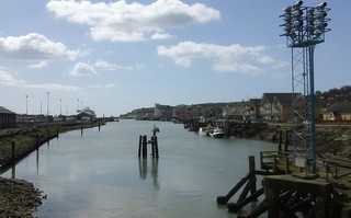
- The walk starts at Newhaven Town station. Turn left (Iceland and Lidl are to your right), cross the river, and follow the walk England Coast Path signs along the river side path / down to the coast.
- The marina road joins the main road,apassing a Co-Op, and you pass a sports pitch (on the inland side)
- Here you have a choice
- The main route follows an uphill road inland marked "Castle Hill". Continue to the Coastwatch station.
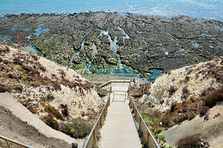
- Or, take the "pedestrian path" to the Victorian Newhaven Fort (a pleasant WW1 themed tourist attraction). Then continue via its car park to join the Castle Hill road.
- Or, continue along the beach road passing The Hope pub. Optionally walk out to the end of the breakwater and back. At the end of the beach, scramble up the cliffs (easy) and contour around Castle Hill (below the Coastwatch Tower).
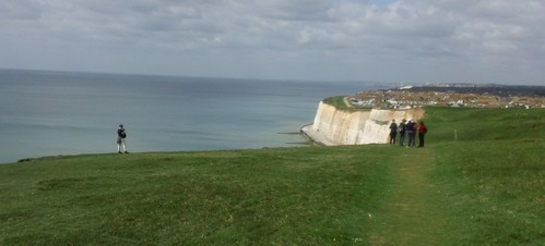
- Head west for some miles on a gently undulating cliff top path, rural at first, with great views out to sea until you reach some houses, where you have a choice:
- Cliff top path : Sea view throughout, pass the Greenwich meridian monument.
- Undercliff path : There are 3 access points. Friars Bay, the first is just before the houses start. The second, Bastion Steps, is by a car wide path with a wide area at the bottom. You need to rejoin the cliff top path at the 3rd one (Howard Park), just inside the western hemisphere, by the Peacehaven pub (not visible from the bottom) as undercliff path ends a little further on.
- Pass the Smuggler's Rest pub. Behinb the pub is a beach access point, but its a dead end.
- Eventually the cliff top path comes close to a busy coastal road as you descend to Saltdean and its Lido. Here you join the under-cliff path (hard surface) and escape the noise of the coast road.
- You can walk backwards along the undercliff path here, but its a dead end - theres a gap between this point and the Smugglers' Rest access point.
- Follow the concrete undercliff path for 3.4km past Rottingdean which has a nice prommenade cafe in a sheltered spot (Molly's at the Beach). There is a cliff top pub a little further, then its a long stetch to the marina. (You can continue along the cliff top path, but its a bit close to the noisy coast road).
- At the marina, cross the lock gates - its nicer, and the path shown on the OS map behind the marina is usually closed due to rock falls. Continue past the yachts and a line of restaurants until you reach The West Quay pub (Wetherspoons) .
- Continue through the Marina (in front of a car park, past McDonalds and Adsa) to the harbour wall.
- You can turn back on yourself to walk along the harbour wall
- This is the start of Brighton's beach. Continue along Marina Drive (at the foot of a low cliff), with a shingle beach to your left. Pass Brighton's gay/nudist beach.
- The pier (free entry) is worth a stroll. Starlings swarm around it at sunset.a This is the start on the beach boardwalk, with many beach level cafes and bars.
- Turn inland by the pier for Brighton Pavilion, the Lanes, shops and cafes.
- For Brighton station, turn inland just after the pier, through an underpass, and continue straight on, uphill.
Brighton to Hove and Portslade
- To continue on to Hove (+2.5km), keep going, choosing between the beach level board-walk (passing cafes, pubs and shops), or less busy road level promenade.
- Pass the i360 tower by the remains of the west pier. Leave the crowds behind as the 2 paths merge to from a wide promenade with a long row of beach huts.
- Turn inland by a sea front apartment block for Hove station. Head north (inland) along Fourth Avenue (wide, with parking in the middle)s for 500m. Turn left (west) on Church Road (cafes, shops) for 400. Turn right (north) on Rutland. In 1km, come to the station
- To continue on to Porstlade (+ another 2.5km), continue in front of the seafront buildings to join another promendade, leaving the crowds of daytrippers completely behind.
- Continue to the end, with a small lake (Hove Lagoon) and cafe (no sea view).
- At the end, just before the "white sea front houses" that block your way ahead, head inland, and up some stairs by a pub to the main road. Cross the road, and head inland along a residential road (north, on either Roman Road or Saxon Road). At the main road, turn left (west, along New Church Road) to Portslade's centre (Tesco, Asda), then right (north, along Station Road)) for its station, and station pub. London trains from here don't stop at Brighton, so shouldn't be too crowded, even in summer.
- Do not try going further along the path (past the "white sea front houses", and marked "Monarch's Way" on the OS Map) along Portslade's shingle beach (towards the tall chimney - a power station). Its a port area. The road is separated from the beach by a very high wall (there are occasional gaps) so there is no view. You can walk along the beach side of the walk - but it is shingle with no path - not even at low tide - very, very hard going. There is a naturist beach at the very start (just after the white houses on the beach) used by locals, not at all like the main naturist beach. At the far end of the shingle beach, there is a cafe (no sea views), and a pedestrian bridge over the harbour to Southwick station.