Islip Circular walk
Pleasant rolling countryside north of Oxford, and the RSPB Otmoor wetland reserve
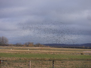
Starlings and Lapwings Murmuration, Otmoor RSPB Reserve
Jan-18 • thomasgrabow on Flickr
swcwalks swcwalk292 banner 39254450334
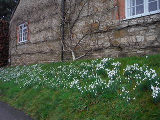


Big Sky over field, near River Cherwell
Jan-18 • thomasgrabow on Flickr
swcwalks swcwalk292 walkicon 39964238711

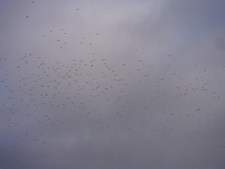
Starlings and Lapwings Murmuration, Otmoor RSPB Reserve
Jan-18 • thomasgrabow on Flickr
swcwalks swcwalk292 39964389931
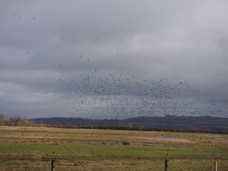
Starlings and Lapwings Murmuration, Otmoor RSPB Reserve
Jan-18 • thomasgrabow on Flickr
swcwalks swcwalk292 39964378211
Starlings and Lapwings Murmuration, Otmoor RSPB Reserve
Jan-18 • thomasgrabow on Flickr
swcwalks swcwalk292 39254427484
| Length |
17.4 km (10.8 miles) |
|---|---|
| Toughness |
3/10 |
| Maps |
OS Landranger 164, Explorer 180 |
| Walk notes |
This walk takes in a quiet area of pleasant rolling countryside north of Oxford, with rivers, fields, woods and a major wetland nature reserve, RSPB Otmoor, extremely popular with birdwatchers. Recent sightings: Otmoor Birding Blog. It also visits some attractive villages and a couple of old churches with interesting features. Otmoor has literary connections, notably with Lewis Carroll. |
| Transport |
Islip is on the Chiltern Railways line from Marylebone to Oxford, but has a fairly infrequent service. If there is no convenient direct train, it is sometimes possible to travel one stop further to Oxford Parkway and change there for a train back to Islip. Alternatively, it is possible to start or finish the walk at Oxford Parkway, which has a half-hourly service from Marylebone. Suggested train: Take the train nearest to 9:30am from Marylebone. This will often be nearer to 9:00am, except on Sundays. Return trains in the afternoon are usually more conveniently timed, but are still infrequent, so check the times before leaving the station in the morning. |
| Walk options |
|
| Lunch |
The Abingdon Arms, High Street, Beckley (01865 655667) A 17th century pub, with an outside terrace overlooking the reserve. Opens at noon. Closes 6pm Sunday. |
| Tea |
The Red Lion, High Street, Islip (01865 375367) A 17th century daytime coffee shop and pub. Opens noon Wed-Sun (closed Mon, Tue). Food 12-3 and 5-8. |
| Profile | |
|---|---|
| Help Us! |
After the walk, please leave a comment, it really helps. Thanks! You can also upload photos to the SWC Group on Flickr (upload your photos) and videos to Youtube. This walk's tags are: |
| By Train |
Out (not a train station) Back (not a train station) |
| By Car |
Start OX5 2TQ Map Directions |
| Amazon | |
| Help |
National Rail: 03457 48 49 50 • Traveline (bus times): 0871 200 22 33 (12p/min) • TFL (London) : 0343 222 1234 |
| Version |
Jan-22 Chris L |
| Copyright | © Saturday Walkers Club. All Rights Reserved. No commercial use. No copying. No derivatives. Free with attribution for one time non-commercial use only. www.walkingclub.org.uk/site/license.shtml |

Walk Directions
- Leave Islip station without crossing the footbridge, turn right up the approach road, cross the B4027 and turn left towards Islip [i] village.
- In 80m fork right away from the main road to go along Church Close, and then continue on Church Lane, passing the village shop to the right (open 10am to 12pm except Wednesday and Sunday).
- Just past the church on the left, turn left up steps to go through the churchyard of St Nicholas, Islip [ii], exiting to a small green with an oak tree and the village stocks. A possible tea stop, The Red Lion, is to the left.
- Turn right down The Walk, passing the Old Rectory on the left, with its blue plaque commemorating William Buckland [iii]. Turn left at the bottom and in 40m, opposite the White Swan Inn [iv], turn right to cross the River Ray [v].
- Go uphill and, just after leaving Islip between white posts on either side of the road, turn left on the Oxfordshire Way footpath along a concrete drive.
- In 30m bear right on a stony track and in 100m cross a stile to go along the right-hand edge of a field to a metal kissing-gate in its corner.
- Follow the left-hand edge of the next field and go through a metal gate. Cross the middle of three further large fields, separated by gates. (!)Just before the top of the rise in the third field, the footpath forks left away from the tractor tracks. At the far side of the field, go through a metal kissing-gate and along the right-hand edge of a field down to the village of Noke [vi].
- Turn right on the road (or left to stay on the road to point 1). In 120m turn left over a stile and go down the left-hand edge of a field. Cross a wooden footbridge and continue in the same direction across the middle of the next field, where the path may be ill-defined.
- Join a road and continue ahead for 100m. At a sharp right-hand bend, with pretty thatched cottages around, turn left and in 40 m turn right at a footpath sign on a gatepost.
- Follow a wide grassy track that bends right and later narrows before kinking left and right to cross a wooden footbridge where the path turns right and rejoins the road in 160m where it crosses a stream at the entrance to Hill End Farm and Lower Farm (point 1).
- Here you have an option to continue straight across the road for a short cut to lunch at Beckley (see directions at end of main directions). This short cut omits the section through Otmoor.
- Turn left on the road, forking left on a car-wide track in 100m, where the farm drive swings right. In 300m (the track here is liable to flooding after prolonged rain) you reach Otmoor [vii] and turn right along a wide track.
- Across a ditch to the left is the main area of Otmoor. In 900m the path reaches The Wetland Watch [viii] bird hide to the right.
- On the other side of the main track is a visitor trail that takes you further into the wetland habitat. Retrace your steps to the track and turn left to continue the walk.
- In 800 m, just past a breezeblock pump house on the left beside a telegraph pole, turn right across a ditch on a stony path and turn left in 400m to go through a wooden kissing-gate beside a field gate. Then bear right onto a lane.
- In 100m on the left is the entrance to the MoD Otmoor range that occupies a large area to the east of the nature reserve. The lane continues for 1.4km, gradually starting to climb into the village of Beckley, where it turns sharp right to reach The Abingdon Arms, the recommended lunch pub, in 120m.
- [AA] The shortcut rejoins here.
- For the next 3km the route follows the Oxford Greenbelt Way (OGW) though there are only occasional signs that indicate this
- Coming out of the pub, turn right to continue along the High Street, passing on the left the Beckley Art Box, a disused phone box now used for occasional art displays or installations. At the end of the road is the Church of the Assumption of the Blessed Virgin Mary [ix], Beckley, well worth a visit.
- At the end of the High Street, turn sharp left uphill (or turn right if coming from the church) to go up New Inn Road. In 100m, turn right along Common Road.
- In 600m, with cottages on the left, turn right at a footpath sign to go through a wooden gate into a field. Turn left to go alongside the road initially, gradually curving right on a wide track to pass through a gap at the bottom left-hand corner of the field.
- Fork left at a footpath post and go through trees alongside a barbed-wire fence to the right. At the end of the fence there are fine views of Ot Moor.
- Go half-left down a grassy field to its bottom left-hand corner. Go through a metal gate and turn left on an enclosed path between hedges. In 220m cross a farm track to continue on the OGW with a stream or ditch to the left.
- In 350m, cross a footbridge and go through a metal gate into a field. Aim for the corner of a small fenced plantation of trees ahead and continue alongside the fence.
- At the end of the field, go through a wooden gate and onwards through another new plantation. Pass through another wooden gate and go left along a wide path to reach a main road (the B4027).
- Turn left along the grass verge and in 240m cross the road to follow a footpath sign towards Elsfield. At the bottom of a large field bear half-left to go up its right-hand edge.
- In 380m pass through a gap on the right and turn left to go along the left-hand edge of a field, bending right and continuing uphill to reach the edge of a wood (marked as Woodeaton Wood on the OS map). Here the route leaves the OGW.
- Enter the wood beside a footpath post and turn right on a winding path close to the edge of the wood. In 300m the path emerges from the wood and continues downhill alongside a spur of the wood to the left.
- At the end of the wood continue ahead aiming for the corner of a copse at the bottom of the field. The OS map shows the path turning left across the middle of the field before reaching the copse but it is not visible on the ground, so it is easier to turn left alongside the copse and follow the edge of the field for 550m until you reach a road.
- Turn right on the road and shortly enter the village of Woodeaton [x]. In 400m you reach Holy Rood [xi] church with some unusual features that are worth seeing. On the adjacent village green is a heavily weathered mediaeval cross.
- Just past the church, turn left through a metal fieldgate on to a car-wide grassy track signposted to Cutteslowe. In 300m you pass a small listed building, the Woodeaton Manor House Folly, on the left. In a further 400m, bear right at a track junction, and in 250m, turn left at the corner of a hedge, coming in 400m to a footpath junction.
- To finish the walk at Oxford Parkway station, turn left here and follow the directions at the end of the main walk directions
- Turn right on a footpath that bends gradually right alongside a ditch to the left. In 400m the path reaches the River Cherwell. Turn right and follow the banks of the river upstream for 1km as it gradually bends left.
- The footpath then forks right across the corner of a field on a clear path, and continues gradually uphill across the middle of the next field. At the far edge of the field go along a grassy footpath heading north to join a gravel drive that bends right to go down to a road.
- Turn left on the road and in 100m cross the River Ray to re-enter Islip on the same road by which you left it, with The Swan Inn opposite. Teatime refreshments can be had at The Red Lion in the High Street.
- You can return to the station by following the main road for 400m, passing the Red Lion en route, or by retracing your morning steps past the church. On reaching the railway, cross the bridge and take the access path on the right, which leads down to the London-bound platform.
FINISH AT OXFORD PARKWAY STATION
- Turn left at the footpath sign and in 15m turn right across a wooden footbridge to continue straight on across the middle of a field for 400m. Cross a concrete bridge (Sparsey Bridge) over the River Cherwell and continue straight ahead along a grassy track that bends slightly right after 250m.
- On reaching a cross-path at a three-arm footpath sign, continue straight ahead, now on a concrete farm drive between fields. This continues for 1.1km to reach a main road, the A4165.
- Turn right along the road for 450m, and cross straight over a road to the right that has a pedestrian refuge in the middle. That road provides vehicle access to the station. Continue uphill on the A4165 towards the bridge ahead. On reaching a bus stop, fork right on a metalled footpath that leads directly down into Oxford Parkway station. The platform for trains to London is over the footbridge.
MORNING SHORTCUT TO BECKLEY
- After reaching point 1 (main directions, para 10), go straight across the road and through a wooden kissing-gate, still on the Oxfordshire Way. Stay on an enclosed path for 1.2km, turning left at the corner of Noke Wood, where the path is separated from the wood by a deep ditch.
- After 360m alongside the wood, the path turns right to enter the wood, emerging after 120m. Follow the path to a metal kissing-gate and then go half-left up a sloping field, aiming for a metal field-gate at the top. Go through, or round, a metal kissing-gate, and up a stony track to join a lane at the edge of Beckley.
- Turn right on the lane and in 300m, at a road junction with the church on your right, turn left along the High Street to reach the Abingdon Arms in 200m. You will return along the High Street later, so you could choose to visit the church either before or after lunch.
- Resume the main walk at the Abingdon Arms, point [AA] above
Footnotes
- [i] Islip is a village north-west of Oxford that was the birthplace of Edward the Confessor. As a result, it has a close association with Westminster Abbey, and several nineteenth century rectors became Deans of Westminster. A late 17th century rector, Dr Robert South, built a new rectory and founded the village school that bears his name.
- [ii] The church of St Nicholas, Islip dates from the 12th century and contains signs of its association with Westminster.
- [iii] William Buckland, a mid-Victorian Rector of Islip and Dean of Westminster, was also a distinguished scientist and the first professor of geology at Oxford, who was the first to recognise the existence of dinosaurs.
- [iv] The White Swan Inn is now a guest house, converted from a traditional country pub. The bar and restaurant closed in 2015.
- [v] The River Ray is a tributary of the River Cherwell that rises in Buckinghamshire and joins the Cherwell just south-west of Islip.
- [vi] Noke is a small village with a 13th century church on the edge of Otmoor, Along with other villages that encircle Otmoor, it is known as one of the “Seven Towns of Otmoor”.
- [vii] Otmoor, or Ot Moor, is large area of marshland that was drained and enclosed into fields in the early nineteenth century. In 1997 a large part of it was taken over by the RSPB and was gradually restored to its original condition. It is now managed as a wetland nature reserve that provides a home for thousands of waterfowl, as well as many other bird species. It is extremely popular with birdwatchers.
- [viii] The Wetland Watch is a large wooden bird hide used for observing the many species of birds that inhabit Otmoor. It contains information panels about Otmoor, its history, wildlife and literary associations. Lewis Carroll, a Beckley resident, is believed to have based the chessboard setting of Through the Looking-Glass on the view from a hilltop of the grid layout of Otmoor fields. John Buchan, JRR Tolkien and Susan Hill are other authors whose works incorporate Otmoor.
- [ix] The 13th century Church of the Assumption of the Blessed Virgin Mary, in Beckley contains a number of interesting features, including mediaeval wall paintings, a skew chancel and a hagioscope or squint.
- [x] Woodeaton is a small peaceful village with evidence of occupation dating back to Roman times. Woodeaton Manor House, built in 1775, is now a school for pupils with special educational needs. The weathered remains of a 13th century preaching cross can be seen on the village green next to the church.
- [xi] Holy Rood church, Woodeaton, is an unmodernised 13th century church with a manorial pew and old-fashioned box pews, a rood screen and inscribed rood beam, a mediaeval wall painting of St Christopher and a minstrels’ gallery. The tower is built inside the church, due to the lie of the land.