Ladybower Inn Circular via Alport Castles and Derwent Reservoirs walk
A grassy ridge to Britain’s longest inland landslip. Descend to skirt the famous Derwent Reservoirs. Hilly return options across moors or along edges.
The Tower, Alport Castles
SWC Walk 349 - Ladybower Inn Circular (via Alport Castles and Derwent Reservoirs)
Sep-19 • thomasgrabow on Flickr
swcwalks swcwalk349 banner 49018151791
![Win Hill Pike, from Thornhill Brink, with Stanage End behind SWC Walk 349 - Ladybower Inn Circular (via Alport Castles and Derwent Reservoirs) [Win Hill Ending]](https://live.staticflickr.com/65535/49018367402_64258c1e53_n.jpg)
Win Hill Pike, from Thornhill Brink, with Stanage End behind
SWC Walk 349 - Ladybower Inn Circular (via Alport Castles and Derwent Reservoirs) [Win Hill Ending]
Oct-19 • thomasgrabow on Flickr
swcwalks swcwalk349 banner 49018367402
Engineered Path towards Alport Castles, Bleaklow looming in the distance
SWC Walk 349 - Ladybower Inn Circular (via Alport Castles and Derwent Reservoirs)
Sep-19 • thomasgrabow on Flickr
swcwalks swcwalk349 walkicon 49018152881

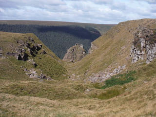
Landslipped Area, Alport Castles
SWC Walk 349 - Ladybower Inn Circular (via Alport Castles and Derwent Reservoirs)
Sep-19 • thomasgrabow on Flickr
swcwalks swcwalk349 walkicon 49018354527
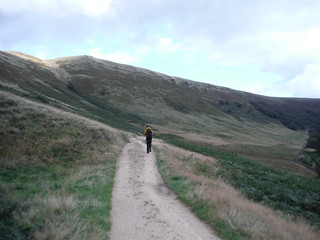
Lone Walker in Cold Side
SWC Walk 349 - Ladybower Inn Circular (via Alport Castles and Derwent Reservoirs)
Sep-19 • thomasgrabow on Flickr
swcwalks swcwalk349 walkicon 49017622133
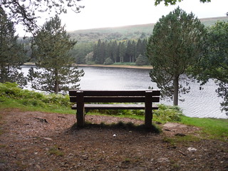
Bench with Views, Upper Derwent Reservoir
SWC Walk 349 - Ladybower Inn Circular (via Alport Castles and Derwent Reservoirs)
Sep-19 • thomasgrabow on Flickr
swcwalks swcwalk349 walkicon 49017620793
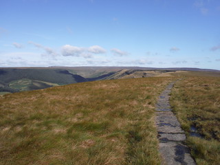
![Hey Ridge, separating Woodlands Valley and Alport Dale, from track up Blackley Hey SWC Walk 349 - Ladybower Inn Circular (via Alport Castles and Derwent Reservoirs) [Win Hill Ending]](https://live.staticflickr.com/65535/49017648318_841bba95af_n.jpg)
Hey Ridge, separating Woodlands Valley and Alport Dale, from track up Blackley Hey
SWC Walk 349 - Ladybower Inn Circular (via Alport Castles and Derwent Reservoirs) [Win Hill Ending]
Oct-19 • thomasgrabow on Flickr
swcwalks swcwalk349 walkicon 49017648318
| Length |
26.9 km (16.7 mi), with 715m ascent/descent. For a shorter or longer walk see below Walk Options. |
|---|---|
| Toughness |
8 out of 10, with 6 ½ hours walking time. For the whole outing, including trains, sights and meals, allow at least 12 ½ hours. |
| Walk Notes |
You cross Ladybower Reservoir and rise through pastures to Crook Hill to follow a grassy ridge with fine views to Win Hill and the Great Ridge, out towards the Kinder Scout and Bleaklow upland peat bog plateaus and across the Derwent Valley to Derwent Edge. At Alport Castles, the fascinating site of Britain’s longest inland landslip with its rocky pinnacles and debris, you turn down from the ridge along a good track through grouse moors into the wooded Derwent Valley and follow Howden Reservoir’s shore to cross Slippery Stones packhorse bridge into the open wild countryside of the Upper Derwent Valley.
Three variations of the return route break the long, nearly flat reservoir-side walk by climbing up a hill or ridge with fantastic views and descending back to the reservoirs further along.
|
| Walk Options |
An Alternative Start at Fairholmes Bus Stop (Line H1 Derwent Dams – Blue John Cavern, 7 buses per day Sat/Sun) cuts 4.4 km/2.7 mi and 100m ascent.
At the end of the walk, you could retrace the outbound route (higher and a bit longer, but quieter) instead of following the A57 Snake Road to the Ladybower Inn. An Alternative Route leads from Alport Castles down through the Woodlands Valley and up to Win Hill. This is 22.4 km/13.9 mi long with 804m ascent, and also rated 8/10.
|
| Maps |
OS Explorer: OL1 (The Peak District – Dark Peak Area)
|
| Travel |
Ashopton, Ladybower Inn Bus Stop, map reference SK 204 864, is 16 km west of Sheffield City Centre, 233 km north west of Charing Cross, 221m above sea level, and in Derbyshire. It is served by bus lines 256/7/8 from Sheffield Interchange to Bakewell (journey time 28 mins from Sheffield (04/22: £4.00 one way, £6.00 return). Sheffield is the terminus of the Midland Main Line from London St. Pancras, with up to two trains per hour (journey time from 118 mins Mon-Sat, longer on Sundays). Saturday Walkers’ Club: This walk can be done as a day walk from London, despite the infrequent bus service. Take a train no later than 8.00 hours. |
| Lunch |
Picnic. |
| Tea |
Derwent Café Fairholmes Visitor Centre, Bamford, Hope Valley, Derbyshire, S33 0AQ (01433 650 953). The Derwent Café in the Peak District Visitor Centre is located at the Fairholmes Ending. The Café is essentially a hot and cold food kiosk with a separate entrance to the VC, and it is often open a bit longer than the VC.
|
| Profile | |
|---|---|
| Help Us! |
After the walk, please leave a comment, it really helps. Thanks! You can also upload photos to the SWC Group on Flickr (upload your photos) and videos to Youtube. This walk's tags are: |
| By Car |
Start A57, Hope Valley, S33 0AX Map Directions |
| Amazon | |
| Help |
National Rail: 03457 48 49 50 • Traveline (bus times): 0871 200 22 33 (12p/min) • TFL (London) : 0343 222 1234 |
| Version |
Apr-24 Thomas G |
| Copyright | © Saturday Walkers Club. All Rights Reserved. No commercial use. No copying. No derivatives. Free with attribution for one time non-commercial use only. www.walkingclub.org.uk/site/license.shtml |

Walk Directions
Full directions for this walk are in a PDF file (link above) which you can print, or download on to a Kindle, tablet, or smartphone.
This is just the introduction. This walk's detailed directions are in a PDF available from wwww.walkingclub.org.uk