Laindon Circular walk
Essex Hills, wooded Nature Reserves and panoramic Thames Valley Views
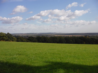
View from One Tree Hill towards Canvey Island
SWC Walk 114 Laindon Circular
Oct-15 • thomasgrabow on Flickr
swcwalks swcwalk114 walkicon banner 22342696035
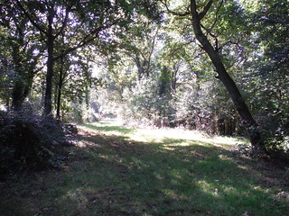
Marks Hill Nature Reserve, Path (I)
SWC Walk 114 Laindon Circular
Oct-15 • thomasgrabow on Flickr
walkicon swcwalks swcwalk114 22342833025

But Why? Tree in Westley Heights Park
SWC Walk 114 Laindon Circular
Oct-15 • thomasgrabow on Flickr
walkicon swcwalks swcwalk114 22342779525
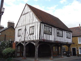
Woolmarket, Horndon-on-the-Hill
SWC Walk 114 Laindon Circular
Oct-15 • thomasgrabow on Flickr
walkicon swcwalks swcwalk114 22329541492
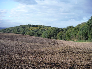
Undulating Field and Lincewood
SWC Walk 114 Laindon Circular
Oct-15 • thomasgrabow on Flickr
walkicon swcwalks swcwalk114 22154345930


| Length | 20.9 km (13.0 mi), with 336m ascent/descent. For a shorter walk see below Walk Options. |
|---|---|
| Toughness | 5 out of 10, with 4 hours 45 minutes walking time. For the whole outing, including trains, sights and meals, allow at least 7 hours. |
| Walk Notes |
This is an energetic and varied figure-of-eight walk through some tranquil, hilly parts of Essex, mostly through woods, both ancient and modern, and through flower-rich meadows and some farmland, which are all parts of Langdon Hills Country Park and the neighbouring Langdon Nature Reserve (which itself consists of five separate reserves). The hills form a crescent shaped ridge running West-to-East, giving panoramic views over the Thames Estuary from many points: out to Canvey Island and Fobbing Marshes in the East, across to Kent and to London’s Skyline in the West.
|
| Walk Options |
A couple of shortcuts cut out 2.4 km (1.5 mi) and 2.6 km (1.6 mi) respectively.
|
| Maps | OS Explorer: 175 (Southend-on-Sea & Basildon)
|
| Travel |
Laindon Station, map reference TQ 680 881, is 39 km east of Charing X, 44m above sea level and in Essex. It station is on the London, Tilbury and Southend Railway line from Fenchurch Street to Shoeburyness in eastern Essex, with four trains an hour Mon-Sat and two on Sundays, journey time is between 30 and 34 minutes. All trains stop at one or more of the following DLR, Overground or Underground Stations: Limehouse, West Ham, Barking, Upminster. Saturday Walkers' Club: Take the train nearest to 09.30 hours. |
| Lunch |
The Bell Inn High Road, Horndon-on-the-Hill, SS17 8LD. Located 10.4 km from the start of the walk. The Bell is featured in all the 'serious' guides and has won numerous industry awards. Consequently, the restaurant area is often fully booked well in advance. The bar area operates on a first-come-first-serve basis though, but serves a different menu.
|
| Tea |
Langdon Visitor Centre Dunton Plotlands, Lower Dunton Road, Basildon, SS16 6EB. Langdon Visitor Centre is located 3.1 km from the end of the full walk. After a complete rebuild, the new centre has opened in summer 2021. |
| Profile | |
|---|---|
| Help Us! |
After the walk, please leave a comment, it really helps. Thanks! You can also upload photos to the SWC Group on Flickr (upload your photos) and videos to Youtube. This walk's tags are: |
| By Train |
Out (not a train station) Back (not a train station) |
| By Car |
Start SS15 6AB Map Directions |
| Amazon | |
| Help |
National Rail: 03457 48 49 50 • Traveline (bus times): 0871 200 22 33 (12p/min) • TFL (London) : 0343 222 1234 |
| Version |
Apr-24 Thomas G |
| Copyright | © Saturday Walkers Club. All Rights Reserved. No commercial use. No copying. No derivatives. Free with attribution for one time non-commercial use only. www.walkingclub.org.uk/site/license.shtml |


Walk Directions
Full directions for this walk are in a PDF file (link above) which you can print, or download on to a Kindle, tablet, or smartphone.
This is just the introduction. This walk's detailed directions are in a PDF available from wwww.walkingclub.org.uk