Leigh and Penshurst walk
The Eden valley, Penshurst Place and a rural pub for lunch.

DSCF0958
Rock Inn, Hoath Corner
Jun-09 • Sean O'Neill
banner, swcwalk92, swcwalks 5483886904130214690 P

DSCF0986
Converted oast house, Salmans Manor
Jun-09 • Sean O'Neill
banner, swcwalk78, swcwalk92, swcwalks 5442689561645889746 P

1005300146
Penshurst Place
May-10 • Sean O'Neill
swcwalk78, swcwalk92, swcwalks, walkicon 5483890487590077618 P

1005300146
Penshurst Place
May-10 • Sean O'Neill
swcwalk78, swcwalk92, swcwalks, walkicon 5483888194384376274 P
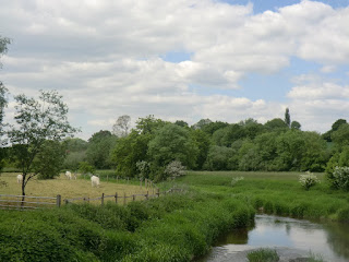
CIMG7119
River Eden near Penshurst
Jun-13 • Sean O'Neill
swcwalk92, swcwalks, walkicon 5884990269858555314 P

CIMG8439
Harden Vineyard in August
Aug-13 • Sean O'Neill
swcwalk235, swcwalk78, swcwalk92, swcwalks, walkicon 5914268117646008306 P

CIMG8439
Harden Vineyard in August
Aug-13 • Sean O'Neill
swcwalk235, swcwalk78, swcwalk92, swcwalks, walkicon 5914275095818401698 P
| Length |
Main Walk, from Leigh to Penshurst: 13½ km (8.4 miles). Three hours 10 minutes walking time. For the whole excursion including trains, sights and meals, allow at least 8 hours. Circular Walk, from Leigh: 18 km (11.2 miles). Four hours 15 minutes walking time. Alternative Walk, from Penshurst to Leigh: 15½ km (9.6 miles). Three hours 35 minutes walking time. Alternative Circular Walk, from Penshurst: 12½ km (7.8 miles). Two hours 55 minutes walking time. |
|---|---|
| OS Map |
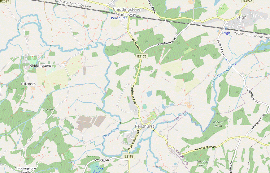
Explorer 147. Leigh Station (map reference TQ546462) and Penshurst Station (in Chiddingstone Causeway, TQ519467) are both in Kent, 4 km and 7 km W of Tonbridge respectively. |
| Toughness |
3 out of 10 (4 for the Circular Walk). |
| Features |
This is a group of walks to and from adjacent stations on the Redhill–Tonbridge line, all centred around the hamlet of Hoath Corner and its traditional rural pub: “all dogs very welcome…children must be kept on a lead!”. The link routes to and from Leigh station have been taken from the Leigh to Tunbridge Wells walk (1–15) and the Hever to Leigh walk (1–19), but the other sections are in less familiar Wealden territory. The Main Walk options start from Leigh station and head west through parkland to the attractive village of Penshurst. After crossing the River Eden there is a gentle climb from Salmans Manor to the lunch pub in Hoath Corner. The Alternative Walk options start from Penshurst station (almost 3 km north of its village, in Chiddingstone Causeway) and head south through low-lying farmland in the Eden valley to join the other route at Salmans Manor. From Hoath Corner all routes head north to another tiny settlement at Hill Hoath, where there is a choice of endings. You can either continue through the picturesque village of Chiddingstone and return from Penshurst station, or take a longer route looping back through Penshurst village to Leigh station. Both Penshurst and Chiddingstone have interesting historic houses which you could visit, and all the routes go through at least one of these villages. Penshurst Place is a well-preserved medieval manor house with an attractive formal garden, the home of the Sidney family since the 16thC. It is open weekends from mid-February to March, and daily from April to October; admission is £15, or £13 for the gardens only (2024). Chiddingstone Castle is a castellated manor house rebuilt in the 19thC, containing an unusual collection of art and curiosities left behind by its late owner, Denys Eyre Bower. It is currently open Sun–Wed from April to October; admission is £11 (2024). The grounds are normally open daily (free entry but donations welcome). The Wealden soil does not drain well and parts of the walk can be muddy even after moderate amounts of rain. |
| Walk Options |
In addition to the routes outlined above you could simply omit the outer loops on those walk options which feature a crossover design, making two very Short Walks. Either of these would be a good choice if you wanted to spend time visiting Penshurst Place. The short Alternative Circular Walk – which does not go through Penshurst itself! – has been included here for completeness. The Penshurst Circular walk (#300) contains some more satisfying circular routes around Bough Beech Reservoir to the north of the railway line. |
| Transport |
Leigh and Penshurst are adjacent stations on a sleepy branch line with an hourly off-peak service between Tonbridge and Redhill. Travelling from Charing Cross and changing at Tonbridge is usually 10–15 minutes quicker than going via Redhill. The most flexible ticket is an “Any Permitted” return to Penshurst, but you can buy a cheaper “Via Redhill” return to Leigh (Kent) if you will be going out and back on this route. If you want to finish the walk in Penshurst village, Metrobus 231 & 233 combine to give a regular service to Chiddingstone Causeway (for Penshurst station) and Edenbridge in one direction, and Tunbridge Wells in the other (Mon–Sat). If driving, neither station has a car park but roadside parking is available (at Penshurst, use the lane leading to the south side of the station). |
| Suggested Train |
Take the train nearest to 10:00 from Charing Cross to Leigh for one of the Main Walks, or nearest to 10:30 to Penshurst for the Alternative Walks, changing at Tonbridge in both cases. |
| Train Times |
|
| Timetables |
|
| River Levels |
|
| Lunch |
The intended lunch pub for all but the two Short Walks is the attractive Rock Inn (01892-870296) in the hamlet of Hoath Corner (after 7½ km if starting from Leigh; 6¼ km from Penshurst), which has some outside seating at the front and a small back garden. As with any small pub in a rural location, call beforehand to check that it will be open (and serving food). On the walk routes which go through Penshurst you could get a pub lunch at the up-market Leicester Arms Hotel (07845-623821) or a light meal at the Porcupine Pantry (see below). However, this village is better placed on the two Short Walks and comes relatively early or late on the other walk options. On the walk routes finishing at Penshurst station you might be able to get a late pub lunch in Chiddingstone at the Castle Inn (01892-870371; closed Mon), which has a particularly attractive back garden. |
| Tea |
On the walk routes finishing at Leigh station there are two options for tea in Penshurst. In the centre of the village the Fir Tree House (01892-870382) tearoom has a large garden and is open from 2.30-6pm, but is closed on Mondays (except Bank Holidays, when it is closed the following Tuesday; it might also be closed on other weekdays in winter). A good alternative is the Porcupine Pantry (01892-871277), just outside the main entrance to Penshurst Place; it has indoor and outdoor seating and is open daily to non-visitors to 6pm. On the walk routes finishing at Penshurst station the suggested tea place is the Tulip Tree (01892-870326) in Chiddingstone. Tucked away in a converted coach house behind the Chiddingstone Stores, this popular tearoom is open daily to 5pm. When Chiddingstone Castle is open its equally good Tea Room (01892-870347) is open to non-visitors. If you are not in a hurry to catch a train there are conveniently-placed pubs near both stations. In Leigh the main route passes the Fleur De Lis (01732-832283; closed all day Mon and Tue–Wed afternoon) shortly before the station. Just across the road from Penshurst station in Chiddingstone Causeway, the Little Brown Jug (01892-870318) is usually open all day and serves tea and coffee as well as normal pub fare. |
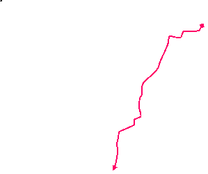
| Profile | |
|---|---|
| Help Us! |
After the walk, please leave a comment, it really helps. Thanks! You can also upload photos to the SWC Group on Flickr (upload your photos) and videos to Youtube. This walk's tags are: |
| By Train |
Out (not a train station) Back (not a train station) |
| By Car |
Start TN11 8RU Map Directions |
| Amazon | |
| Help |
National Rail: 03457 48 49 50 • Traveline (bus times): 0871 200 22 33 (12p/min) • TFL (London) : 0343 222 1234 |
| Version |
Jul-24 Sean |
| Copyright | © Saturday Walkers Club. All Rights Reserved. No commercial use. No copying. No derivatives. Free with attribution for one time non-commercial use only. www.walkingclub.org.uk/site/license.shtml |


Walk Directions
Click the heading below to show/hide the walk route for the selected option(s).


 Walk Map
©
Walk Options ( Main | Alt. )
Click on any option to show only the sections making up that route, or the heading above to show all sections.
- Main Walk, from Leigh to Penshurst (13½ km)
Walk Directions
Click on any section heading to switch between detailed directions and an outline, or the heading above to switch all sections.
If you doing one of the Alternative Walks from Penshurst station, start at §C.
- Leigh Station to Penshurst (3¾ km)
- Head south from the station along the road and turn right onto a footpath. Follow this through the Penshurst Place Estate, veering left after 1½ km to go downhill, past the lake and through Penshurst Park. Pass to the right of Penshurst Place and go through the churchyard to the B2176. Turn right onto the road to enter the village.
- From either platform at Leigh station, take the path down to the road. Turn left and walk along it for 250m, taking care as there is no pavement. At Paul's Hill House turn right up a rough track which soon enters the Penshurst Place Estate. Where it comes to an open field, follow a grassy path across it to the far left-hand corner.
- Continue in the same direction along a broad tree-lined avenue for 1 km, ignoring a footpath off to the right after 100m and another to the left after 500m. Eventually, where another footpath joins from the right, turn left downhill along another tree-lined avenue towards a lake, with Penshurst Place beyond.
- After going through a gate, the right of way continues ahead for 150m and then turns half-right at a footpath signpost, but most walkers bear right onto a clear grassy path cutting off this corner. Go through a gate by the lifeless trunk of the veteran Sidney Oak? (with a plaque recording that it expired in 2016) and continue alongside a fence, with the lake and a line of clipped yew trees on the other side.
- Follow the grassy path up to a kissing gate in the next fence. Go through this and head S across the parkland towards the right-hand side of Penshurst Place. After passing a cricket pitch on your left, cross the estate's driveway via two metal kissing gates. Continue towards the corner of the hedge-topped stone wall guarding the manor house and keep ahead with the wall on your left-hand side.
- At the end of the wall, go through another kissing gate and follow a path through the churchyard of St John the Baptist church? (which is worth visiting; its entrance is on the south side). Leave the churchyard through an archway and go past the picturesque houses in Leicester Square? to the B2176. Turn right onto the road to enter the village, soon coming to the Leicester Arms Hotel (a possible early lunch stop) on your left.
- Penshurst to Salmans Manor (1¾ km)
- Head south-west out of the village on the B2188. At the school, turn right into a lane and follow this to the Warren. Keep ahead along a footpath which crosses the River Eden and continues to Salmans Manor.
- Continue past the pub and keep left at the road junction in the centre of the village. Go along the B2188 for 200m, passing some attractive old buildings (note the horseshoe-shaped doorway? in the garage). Immediately after passing the primary school, turn right into a lane (The Warren).
- Stay on this lane for 600m, eventually passing a row of cottages. Where the lane ends, keep ahead down the right-hand edge of a large field. In the bottom corner go through a metal gate and veer right across the grass to a footbridge over the River Eden?. Cross this and continue on an enclosed path.
- In 200m go through a metal kissing gate and turn right along a narrow fenced path. This takes you around two edges of a large field, with two more kissing gates along the way. After the second of these, do not continue on the broad grassy track ahead (with a tall hedge on its left), but turn right to head NW on another wide track.
-
The track soon comes to a tarmac lane by the buildings of Salmans Manor. Turn left briefly onto the lane, but instead of following it round to the right keep ahead through a wooden side gate to the right of a fieldgate to continue on a tree-lined track.
- A short detour up the lane would give you a fine view of a large mill pond opposite a particularly attractive oast-house conversion.
- Penshurst Station to Wellers Town (3 km)
- Leave the station on its southern side and take a footpath initially heading west, then turn left onto one leading to Vexour Bridge. Cross the River Eden and continue on the footpath going past Vexour and Chantlers. Turn left onto a lane and follow it through Wellers Town.
- If you arrived on a train heading towards Tonbridge, cross the tracks by the footbridge to the westbound platform. Leave the station on its southern side and bear right through a small parking area towards a wooden fieldgate. Go though a metal side gate and bear right to go along a rough track on the edge of a field, with a hedgerow on your right. Continue in the same direction across the next field.
-
On the far side turn left along the field edge. In 150m turn right through a metal fieldgate, as indicated by a footpath marker. Go along the left-hand edge of a small field and over a stile beside another fieldgate into a much larger field. Continue along its left-hand edge for 100m, then go over a stile on the left to head S along the edge of another field, with a line of trees on your right. In 200m go through a gap and keep ahead across the next field.
In the past this field has been divided, so there might be a temporary wire fence on your right.
- At the end of this field go through a small metal gate into another field. Bear slightly right towards the far right-hand corner, where there is a narrow footbridge over a stream in the tree boundary. Cross this and keep ahead across a large meadow, heading SW and skirting a projecting group of trees on the left.
- On the far side go over a stile and turn left onto a lane to cross the River Eden? on the attractive Vexour Bridge. Where the lane swings right keep ahead on the tarmac driveway to Vexour (signposted as a footpath). After climbing for 150m turn right by another signpost onto a short path through a belt of trees and up into the corner of a large field. Keep left and go along its edge, still climbing and passing the buildings of Vexour on your left.
- In 150m keep ahead at a footpath signpost by a large oak tree (the path from the right is one of the return routes from Chiddingstone). In a further 150m, however, turn right (with no signpost) on a grassy strip towards the right-hand edge of some trees surrounding a few houses. On reaching these turn left to go alongside them for 60m, then veer right across a patch of grass onto a long straight driveway. Follow this out to a lane and turn left onto it.
-
You now have 600m of road walking, crossing a stream halfway along and climbing through Wellers Town. About 75m after passing the last house in this hamlet, turn left off the lane at a footpath sign, going over a stile to the right of a metal fieldgate into a field. Across the valley to the right you can see what looks like a long low building but is actually a trompe-l'oeil.
The back of some derelict farm buildings at Wat Stock have been crudely painted to resemble a manor house.
- Wellers Town to Salmans Manor (1¼ km)
- Turn left off the lane onto a footpath leading to Wat Stock. Continue on a bridleway heading south-east and then south to Salmans Manor.
- Go across the grass, aiming a little to the left of the building and passing a few isolated trees in the field. As you go down the slope you will see a plank bridge over a ditch at the bottom. Go over this and through a metal kissing gate into a field.
- Make your way straight up the field towards the left-hand end of the building. At the top go through a metal fieldgate and turn right onto a farm track, passing the derelict barns. At the far end of the barns turn left at a three-way bridleway junction, passing some cottages. The lane swings right and left between ponds in a wooded area, then continues between hedges. At the entrance to Abbotsmerry Barn it turns half-right and goes down a long slope.
- At the bottom you come to the buildings of Salmans Manor, with a large mill pond opposite a particularly attractive oast-house conversion. Shortly afterwards, where the lane veers left, turn right through a wooden side gate onto a tree-lined track.
- Salmans Manor to Hoath Corner (2 km)
- Leave Salmans Manor on a footpath heading west, climbing gradually through fields, woods and the edge of Harden Vineyard. Soon after the path joins a track by Oakenden Farm, turn right and take the path through Puckden Wood to Hoath Corner.
- Go along the track for 100m, with glimpses of the mill pond on your right. Just before a metal fieldgate leading into a large field, turn left through a kissing gate and climb a short flight of steps. This leads through another kissing gate into the field where you continue up its left-hand edge.
- In 150m turn left through a wooden kissing gate into a small enclosure, leaving it by a metal kissing gate in the opposite corner. Bear right and go across a small fenced-in field to another gate. Go through this and continue along the field edge, passing Harden Vineyard? on your left. At the end of the vineyard go over a stile and through some trees to a path T-junction. Turn right and follow the path round to the left.
- In 100m you come to the edge of the wood and go over a stile into a more open area. Follow the enclosed tree-lined path gently uphill between two large fields. At the top continue through a belt of trees to join a driveway by the entrance to “Skipreed”.
- About 100m along this drive, opposite a house “Oakenden”, turn right up a few steps in the earth bank and go over a stile with two footpath waymarkers. Ignore a kissing gate into a field and take the fenced-in path ahead. At the far end go over another stile with two waymarkers and turn right to go through a small metal gate in the wire fence. Continue along the right-hand side of a triangular strip of grassland between fences.
- In the far right-hand corner follow the path down through Puckden Wood. At the bottom the path curves right and then veers left to leave the wood. Climb a broad grassy path between fences and continue along a short driveway to a road junction in the hamlet of Hoath Corner. Follow the road round to the right to come to the suggested lunch stop, the Rock Inn.
- Hoath Corner to Hill Hoath (2 km)
- From Hoath Corner, take the lane heading west for a short distance and turn right onto a footpath which goes via Trugger's Gill to Stock Wood. Turn right at a path junction and follow this footpath through woods and fields to reach Hill Hoath.
- From the pub, return to the road junction and fork right onto the narrow lane heading W, signposted to Markbeech. In 150m turn right at a footpath sign to go down a fenced path between gardens. After crossing a stream the path continues along the right-hand edge of some rough grassland, heading NW.
- Just before the far corner follow the path into the trees and down through a small wooded glen, then back up into the corner of a large field. Keep right, initially alongside a projecting piece of woodland. Where these trees end, bear slightly right across the field to find a path leading into a large wood on the far side.
- The woodland path comes to a T-junction with footpath markers where you turn right onto a potentially very muddy path. The path bends left and soon passes a sign welcoming walkers from the other direction to Stock Wood. Pass to the right of a short fence at the entrance to a field laid out for show-jumping to continue on a narrow path between hedges.
- At the end go through a metal kissing gate and follow a well-trodden path through a long strip of grassland. At the far end go through another kissing gate, down a short slope and turn right onto an earth track. This leads into a short lane through the hamlet of Hill Hoath, where you pass an attractive low-lying house Withers? on the left and reach a three-way road junction.
- Hill Hoath to Chiddingstone (1¼ km)
- Take the lane heading north to the entrance to Chiddingstone Castle. If they are open the suggested route is to cut through the castle grounds to the village, rather than skirting around them on the road.
- At the junction keep left to head N on a quiet country lane. In 300m you pass a corner of the grounds of Chiddingstone Castle on your right (with a locked gate), then in a further 400m come to its main driveway. An estate notice at the entrance confirms that access is permitted through the grounds; they include an attractive fishing lake and some pleasant woodland paths beyond the lawns around the manor house.
-
Road route
- Continue along the lane to a crossroads and turn right. In 250m this road bends right and crosses a stone bridge, with a view of the manor house beyond the lake. In 150m the road turns sharply left by a pedestrian entrance to the castle (the exit for the alternative route).
-
Castle Grounds route
- Turn sharp right off the lane to go up the driveway, which curves gently round to the left in front of the manor house.
- To go directly to its Tea Room without visiting the house and its collections, go past the main entrance and all the way round the back of the house to find the gift shop and tearoom in the far corner.
- After exploring the grounds, return to the front of the house and turn right. Follow the path across an arm of the lake on a footbridge and out through a gate in the castle walls, emerging on a bend in the road.
- There are two more refreshment places along the picturesque village street through Chiddingstone?. The Castle Inn is the first building on the right, and opposite St Mary's church? the Tulip Tree tearoom is up a passageway beside the Chiddingstone Stores.
- Chiddingstone to Penshurst Station via Hampkins Hill (2¾ km)
- Head east along the road to Larkin's Farm and continue along a footpath across the brow of Hampkins Hill. Turn left in front of Vexour and go downhill to rejoin the road, crossing the River Eden at Vexour Bridge. Take the right-hand of two footpaths, heading north-east across meadows and fields to the station.
-
To complete the walk follow the street out of the village, heading E.
- After passing the primary school you could turn right onto a signposted path to see the Chiding Stone?, 200m away. If you take this detour, return the same way.
- After the path to the Chiding Stone ignore public footpaths off to both sides and stay on the lane, climbing gently with good views of the Greensand Hills on your left. In 400m fork right in front of Triangle Oast (with Larkin's Brewery? in the farm buildings on your left). Almost immediately turn left at a footpath signpost onto a clear path across the brow of Hampkins Hill.
- At the far end of the field turn left along its edge. In the corner veer right down a narrow path through a belt of trees and turn left onto a tarmac driveway. At the bottom rejoin the lane you left at Triangle Oast, crossing over the River Eden on the attractive Vexour Bridge. On the other side bear right off the lane by a pair of footpath signposts, going over a stile to the left of a metal fieldgate.
- Take the right-hand of two faint grassy paths to head NE across a large meadow, skirting a projecting group of trees surrounding a loop of the river. At this point the path splits: in practice you could take either path but the correct route is to fork left, reaching the tree boundary 30m to the left of a fieldgate.
-
In the trees cross a stream on a narrow footbridge and bear left across a field, aiming for a gap in the trees on the far side, 125m away. Go through a small metal gate to the right of a fieldgate and keep ahead across the next field.
In the past this field has been divided, so there might be a temporary wire fence on your left.
- In 200m go through a gap and continue along the left-hand edge of another field. At the far end go over a stile into a large field and turn right to head E along its edge.
- In the field corner go over a stile beside a metal fieldgate. In 50m go through another gate and turn left along the field edge. About 100m before reaching the railway embankment ahead, turn right by a footpath marker post to go straight across the field. On the far side go through a gap to continue on a rough track along the left-hand edge of a field.
- In the corner go out through a metal side gate and across the parking area for a timber yard onto Platform 1 of Penshurst station?, for trains to Redhill. Cross the footbridge to Platform 2 for trains to Tonbridge and/or refreshment at the Little Brown Jug, directly opposite the station on the B2027.
- Chiddingstone to Penshurst Station via Beckett's Farm (3 km)
- Turn left off the lane outside the village onto a footpath heading north to a footbridge over the River Eden. Fork right off the main path onto a footpath leading to a house (Chested). Go out along its driveway and turn left briefly onto a minor road, then turn right onto a footpath heading east across fields to Beckett's Farm. Go across its driveway onto another footpath heading east and then north-east across fields to the station.
- …
- 50m after the path to the Chiding Stone, turn left off the lane onto a signposted footpath, the driveway to a house “Coachmans”. At the end of the drive bear right as indicated in front of a wooden fieldgate onto a fenced path skirting around the house. On the far side follow the path gently downhill alongside a wood. Keep ahead where another footpath joins from the left to reach the River Eden, crossing it on a new wooden footbridge.
- Shortly after crossing the river go through a metal gate on the right into the corner of a field. Turn left to continue in your previous direction along its edge, veering slightly away from it at the end to go through a gap into the bottom of a sloping field. Make your way over to its right-hand edge and go up to the top corner.
- After going through a gap in the trees make a similar manoeuvre in the next field to continue along its right-hand edge, heading N. In the corner go over a stile to the right of an old metal gate and bear right across a field which slopes downhill, aiming just to the right of an attractive tile-hung house “Fissenden” which comes into view.
- Go over a stile onto the house's driveway and follow it out to a lane (Hampkin's Hill Road). Turn left onto the lane, then in 60m turn right onto a signposted footpath. Make your way past a metal fieldgate to go along a strip of grassland between a hedge and a meandering stream.
- At the end of the hedge bear left towards the field corner. Go through a wide gap in this potentially muddy area and veer right up a slope to continue along the right-hand edge of a field, towards the buildings of Beckett's Farm. Go over a stile in the field corner onto a track towards the farm buildings.
- Veer left briefly onto the driveway leading away from the farm, then immediately go over a stile on the right into a large field. After passing the farmhouse turn half-right to go across a patch of rough ground (with no clear path) towards a plank bridge over a ditch 100m away. Go over this and continue along the right-hand edge of a large field, heading E.
- …
- …
- Hill Hoath to Penshurst (3½ km)
- Follow the Eden Valley Walk south-east via Wat Stock, eventually crossing the River Eden into Penshurst. Turn right on the B2176 to enter the village.
- At the junction turn right, now on the Eden Valley Walk? (EVW). After passing some more houses keep left where the lane opens out, ignoring another footpath ahead past some stables. Head E along a farm track and take a surfaced path to the left of some new buildings. Continue on a grassy path and fork right where this splits, onto a clear straight path heading SE.
-
In 300m, soon after a narrow path joins from the left, go through a kissing gate into a wood. Continue along a broad woodland path for 400m, climbing gently at first. At the far end go over a stile to emerge on a minor road. Cross the road and continue on a bridleway just off to the right, going through a metal fieldgate to head diagonally across a field on a grassy path. On the far side leave it through another gate and turn left onto a lane.
At a fieldgate on the left after 100m there is a view of the painted barn at Wat Stock (the trompe-l'oeil seen earlier on the Alternative Walk).
- The lane bends to the left round a large pond. In a further 50m keep ahead on an unsurfaced track past some derelict farm buildings, briefly reversing the outward route of the Alternative Walk. You now follow this potentially muddy track (the old coach road) all the way down to Penshurst, with a huge array of polytunnels behind the line of trees on your right and glimpses of the Eden Valley on your left.
- After a long descent the track merges with the driveway from Salmans Farm and you cross the River Eden on a brick bridge. In a further 500m you reach the B2176, with Penshurst Place visible in the grounds ahead. Turn right onto the road to enter the village.
-
In 150m you come to the Fir Tree House tearoom on your right, the first of several possible tea places. The walk continues round to the left at the road junction in the centre of the village, where stronger fare is available on your right at the Leicester Arms Hotel.
- The Porcupine Pantry is 600m further on, in the next section.
- Penshurst to Ensfield Bridge (2¾ km)
- Head east out of the village on the access road to Penshurst Place, signposted as the Eden Valley Walk (EVW). Continue on the private road towards Well Place Farm, which you skirt by taking a footpath up a field to its left. Head north-east along a track to Killick's Bank. Turn right onto a footpath going down to the River Medway and continue alongside it to a road. Cross the river on Ensfield Bridge.
- Head E out of the village on the B2176, passing the picturesque houses in Leicester Square?. Where the road turns right keep ahead through a stone and brick archway, now on both the Eden Valley Walk? (EVW) and Cycle Route 12 (CR 12).
-
As you go along the driveway a locked gate in the high brick wall on your left affords you a glimpse of the formal gardens. At the end of the wall you pass the large car park for Penshurst Place on the left.
- The Porcupine Pantry is at the back of this car park. If you detour there for refreshment, return to this lane afterwards.
- Continue along the driveway for 400m (shown as a private road to Well Place, but still a public footpath). Shortly before it starts to ascend, turn left through a squeeze gate into a field, temporarily leaving CR 12. Go along the field edge parallel to the road, then through another squeeze gate. Follow a broad grassy path diagonally up the next field (with a fine view back to Penshurst Place).
- At the top go through a squeeze gate to the right of a fieldgate and head NE along a track. In 80m keep ahead where it joins a concrete lane, rejoining CR 12 for the next 600m to Killick's Bank. After passing this isolated house veer right across a lane junction. Go through a squeeze gate (or over a nearby stile) into a field.
- Follow a faint grassy path downhill, heading E. At the bottom of the field cross a wooden bridge over a backwater and go across the grass to the River Medway. Turn left and walk along the riverbank to Ensfield Bridge. Turn right onto the road to cross over the river, rejoining CR 12 again.
- Ensfield Bridge to Leigh Station (2¼ km)
- Continue on the EVW for a further 700m, then cross back over the river and take the footpath heading north towards Leigh. Go around the village green and turn left onto the B2027. At the Fleur De Lis pub turn left into Lower Green for the station.
- On the other side of the bridge turn left and follow the cycle route for about 400m. Where it bends left down a slope go through a side gate next to a metal fieldgate to maintain direction near the left-hand edge of a large field.
- On the far side go through a metal gate and bear left across the corner of a field towards another gate. Go through it onto a short path through the tree boundary to the cycle route. Keep ahead at this path crossing (leaving the EVW, which continues towards Tonbridge along the Straight Mile? to the right).
- Cross a bridge over a backwater and fork left on the main path, which soon comes to a substantial bridge over the main river. Cross this and follow a grassy path across a meadow, heading NW.
- On the far side go through a wide gap in the hedge and continue along the left-hand side of a field, heading towards a broad track which you can see going up a slope. Go through a kissing gate and follow this track over an embankment and then under a railway bridge carrying the Redhill–Tonbridge line?.
- After another short climb the track swings round to the left. Veer right onto the top of a residential street (Green View Avenue) and go down it to Leigh's village green. Make your way to its far left-hand corner, with St Mary's church? visible on a knoll on the far side.
- Turn left onto the B2027 and go through the village for 250m, passing some attractive almshouses, the Village Stores and a restored water pump. The last refreshment place before Leigh station is the Fleur De Lis pub at the junction with a side road (Lower Green).
- To complete the walk turn left into Lower Green and go along it for 225m to the railway bridge. There are two tarmac paths leading up to the platforms of Leigh station (with no footbridge linking them). Platform 2 is for trains to Tonbridge; go under the bridge and up to Platform 1 for trains to Redhill.
- Wellers Town to Penshurst (2¼ km)
- Turn left off the lane onto a footpath heading towards Wat Stock, but in the hollow turn left to join the Eden Valley Walk further along. Follow this bridleway eastwards, eventually crossing the River Eden into Penshurst. Turn right onto the B2176 to enter the village.
- …
- Turn left along the bottom of the field. In the corner go through a belt of trees via a couple of stiles and turn half-right to go gently uphill across a field. In the middle of the far side two more stiles and a footbridge take you into another field where you follow a faint grassy path slanting up the slope, past a projecting group of trees to the top of the field.
- Go over a stile in the tree boundary and turn left onto a broad track, joining the Eden Valley Walk? (EVW). …
- …
- In 150m you pass the Fir Tree House tearoom on your right (which is usually closed at lunchtime). Keep left at the road junction in the centre of the village to come to the suggested lunch stop on your right, the Leicester Arms Hotel.
- Penshurst to Leigh Station direct (3¾ km)
- Head east out of the village and go along the access road to Penshurst Place, signposted as the Eden Valley Walk (EVW). Continue on a private road towards Well Place Farm, which you skirt by taking a footpath up a field to its left. Leave the EVW and head north for almost 1 km, then turn right and go along a tree-lined avenue and across a field to a minor road. Turn left and follow the road down to the station.
- …
- …
- …
-
At the top veer left in front of a fieldgate, leaving the main branch of the EVW. Follow a grassy path going along the right-hand edge of several large fields (interrupted by a short stretch through a wood) for almost 1 km. At the end of the last field bear right onto a broad tree-lined avenue heading NE.
The final 1½ km is the same as the start of Walk 1–15 (in reverse).
- At the end of the long avenue carry on in the same direction across an open field, then down a rough track to a road. Turn left onto the road, taking care as there is no pavement.
-
Follow the road downhill for 250m to the railway bridge under the Redhill–Tonbridge line?.
…
Platform 1 is for trains to Redhill; go under the bridge and up to Platform 2 for trains to Tonbridge.
- If you want some refreshment the Fleur De Lis pub is 225m ahead at the T-junction with the B2027.
- The Sidney Oak was reputedly planted in 1554 at the birth of Sir Philip Sidney, but is now believed to be many hundreds of years older. Acorns from this ancient tree have been taken all over the world, and cloned saplings planted around the Penshurst estate.
- The Sidney Chapel in St John the Baptist, Penshurst contains many memorials and a fine armorial ceiling, restored in 1966. By the side altar is the Luke Tapestry (in Greek), made by Penshurst's former village doctor: it honours the partnership between medical science and Christianity.
- Some of the half-timbered and tile-hung houses around Leicester Square (named after a favourite of Elizabeth Ⅰ) are Victorian imitations, like the post office house of 1850. “My Flesh also shall rest in Hope”, inscribed on the archway from the churchyard into the square, is from Psalm 16:9.
- The large horseshoe-shaped doorway in the shop / garage is a relic of its days as the village smithy.
- The source of the River Eden is in the Titsey estate, 2 km north-east of Oxted on the slopes of the North Downs. It flows into the River Medway near Penshurst.
- Harden Vineyard grows Regent grapes which are used to make a rosé wine.
- Withers is a 15thC timber-framed hall house, with the bricks on the ground floor being added in the 19thC. The side facing the lane is actually the rear of the house.
- Chiddingstone remains largely unspoilt because the Streatfeild family sold many of the buildings to the National Trust in 1939. It has been used as a location in period films such as A Room with a View.
- St Mary, Chiddingstone contains many memorials to the Streatfeild family. On display is a Vinegar Bible of 1717, so called because in St Luke's Gospel, Chapter 20, “The parable of the vineyard” is written as “The parable of the vinegar”!
- The Chiding Stone is a large sandstone boulder where wrongdoers were supposedly told off (chided) by the other villagers.
- Larkin's Brewery was established in 1986 and moved to the family's farm a few years later. Chiddingstone Cider is also produced here.
- The Penshurst Platform Gallery in the shelter on Platform 1 displays works by local artists associated with Jessops Farm Studios.
- The Eden Valley Walk runs for 24 km, linking the Vanguard Way to the west of Edenbridge with the Wealdway and the Medway Valley Walk in Tonbridge. There are few rights of way alongside the River Eden itself and from Penshurst much of the route actually follows the River Medway.
- The Straight Mile was dug in 1830, an unsuccessful attempt to straighten out the meanders of the River Medway. The canal never filled with water and the project was abandoned.
- The Redhill–Tonbridge line opened in 1842 as part of the main line between London and Dover, and retained that status until the direct line via Sevenoaks opened in 1868.
- St Mary, Leigh dates from the 13thC, although there were earlier churches on this hilltop site. In the 19thC two parties were responsible for different parts of the building and each employed their own architect for its restoration, with the result that the chancel now has a different type of stone from the rest of the church.
This section is the same as the start of Walk 1–15.
If you are doing a Short Walk, go to §K.
Continue the directions at §E.
If you are doing a Short Walk, go to §M.
If you are doing a version of the walk finishing at Leigh station, go to §J.
On a day when the grounds are open to the public you can take the more interesting route in [?].
If you are doing the Alternative Circular Walk, go to §I (to avoid having to retrace 1 km of your outward route from Penshurst station).
If you are doing an Alternative Walk, go to §N.
The remainder of the walk is essentially the same as Walk 1–19.
Walk Notes
» Last updated: July 2, 2024
Return to Top | Walk Map | Walk Options | Walk Directions.