Lidlington to Flitwick Walk
Marston Vale, the Greensand Ridge, mixed woods and open parkland, heathland, historic Ampthill, ruin of Houghton House, a narrow path through the heart of Flitwick Moor.
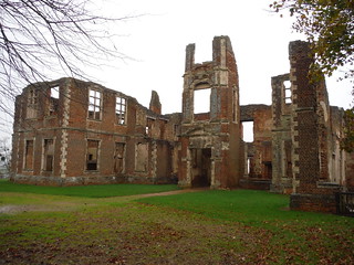
Houghton House, frontal view (II)
SWC Walk 232 Lidlington to Flitwick
Nov-15 • thomasgrabow on Flickr
swcwalks swcwalk232 walkicon banner 22465734134
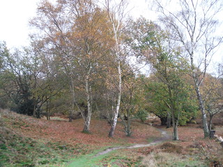
Cooper's Hill Nature Reserve (III)
SWC Walk 232 Lidlington to Flitwick
Nov-15 • thomasgrabow on Flickr
walkicon swcwalks swcwalk232 23062597926

War Memorial near Cooper's Hill, Ampthill (II)
SWC Walk 232 Lidlington to Flitwick
Nov-15 • thomasgrabow on Flickr
walkicon swcwalks swcwalk232 23075004822
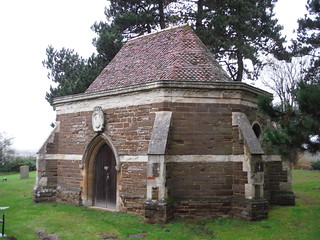
Ailesbury Mausoleum & Crypt, Maulden (I)
SWC Walk 232 Lidlington to Flitwick
Nov-15 • thomasgrabow on Flickr
walkicon swcwalks swcwalk232 22696176229
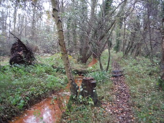
Path through Flitwick Moor
SWC Walk 232 Lidlington to Flitwick
Nov-15 • thomasgrabow on Flickr
walkicon swcwalks swcwalk232 22696035429
| Length | 22.1 km (13.7 mi), with 309/295m ascent/descent. For a shorter walk see below Walk Options. |
|---|---|
| Toughness | 5 out of 10, with 5 hours walking time. For the whole outing, including trains, sights and meals, allow at least 8 hours. |
| Walk Notes | This Central Bedfordshire walk starts in Marston Vale with an undulating ascent up the (Bedfordshire) Greensand Ridge, mainly through mixed woods. It then follows the waymarked Greensand Ridge Walk to open parkland in Ampthill, now with impressive views down into the Vale. Bedfordshire’s largest remaining heathland at Cooper’s Hill is passed through en route to Ampthill’s delightful historic centre. From there it’s back into the park and on to the picturesque ruin of Houghton House, again with commanding views into Marston Vale. After a stretch through ancient King’s Wood the walk leads to Maulden, at times with panoramic views south to the Chiltern Hills, before finally descending from the Greensand Ridge.
The route to Flitwick is then entirely flat and leads through a couple of moors, including a captivating stretch along a narrow path through the very heart of Flitwick Moor, one of the most important wetland sites in the south east of England. |
| Walk Options | Three shortcuts are possible, although they cut out some of the best parts of the walk.
Frequent buses leave Ampthill from near the recommended lunch pubs to either Flitwick or Harlington stations.
|
| Maps | OS Explorer: 193 (Luton & Stevenage)
OS Landranger: 153 (Bedford & Huntingdon) |
| Travel | Lidlington station, map reference SP 989 391, is 14 km east of Milton Keynes and 62m above sea level. Flitwick station, map reference TL 034 349, is 15 km north of Luton and 79m above sea level. Both are in Central Bedfordshire. It is on the (Mon-Sat only) Marston Vale Line, requiring a change from either the West Coast Main Line at Bletchley, or from the Midland Mainline/Thameslink line at Bedford. Flitwick station is on the Thameslink line. Journey times are from 67 to 83 mins from St. Pancras or Euston. The return from Flitwick to St. Pancras takes about 50 mins. Buy a Lidlington return (any route) ticket. Note that the fastest Bedford services from St. Pancras are usually East Midlands trains departing form the upper level platforms, and that Zone 6-extensions are not valid on those trains.
Saturday Walkers’ Club: Take the first train after 9.30 hours if intending to lunch in Ampthill, and an earlier one for lunch in Maulden. |
| Lunch | Plenty of lunch options in Ampthill or Maulden. See the pdf for details. |
| Tea | Plenty of tea options in Maulden or Flitwick. See the pdf for details. |
| Profile | |
|---|---|
| Help Us! |
After the walk, please leave a comment, it really helps. Thanks! You can also upload photos to the SWC Group on Flickr (upload your photos) and videos to Youtube. This walk's tags are: |
| By Train |
Out (not a train station) Back (not a train station) |
| By Car |
Start Map Directions Return to the start: Finish Map Directions Travel to the start: |
| Amazon | |
| Help |
National Rail: 03457 48 49 50 • Traveline (bus times): 0871 200 22 33 (12p/min) • TFL (London) : 0343 222 1234 |
| Version |
Mar-20 Thomas G |
| Copyright | © Saturday Walkers Club. All Rights Reserved. No commercial use. No copying. No derivatives. Free with attribution for one time non-commercial use only. www.walkingclub.org.uk/site/license.shtml |

Walk Directions
Full directions for this walk are in a PDF file (link above) which you can print, or download on to a Kindle, tablet, or smartphone.
This is just the introduction. This walk's detailed directions are in a PDF available from wwww.walkingclub.org.uk