Llanvihangel Crucorney Circular via Bryn Arw and The Skirrid walk
Two easily accessible ridge walks south east of the Black Mountains, quiet pastures with views and a Michelin-starred lunch pub
![Along the Skirrid ridge SWC Walk 347 - Llanvihangel Crucorney Circular (via Bryn Arw and The Skirrid) [taken by Jenny P]](https://live.staticflickr.com/65535/51535297666_8352f700c8_n.jpg)
Along the Skirrid ridge
SWC Walk 347 - Llanvihangel Crucorney Circular (via Bryn Arw and The Skirrid) [taken by Jenny P]
Sep-21 • thomasgrabow on Flickr
swcwalks swcwalk347 banner 51535297666

Bryn Arw from ascent up Llwygy hill
SWC Walk 347 - Llanvihangel Crucorney Circular (via Bryn Arw and The Skirrid)
Sep-19 • thomasgrabow on Flickr
swcwalks swcwalk347 walkicon 49011998333

The Skirrid from ascent up Llwygy hill
SWC Walk 347 - Llanvihangel Crucorney Circular (via Bryn Arw and The Skirrid)
Sep-19 • thomasgrabow on Flickr
swcwalks swcwalk347 walkicon 49011998113

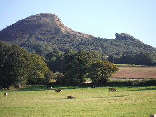
Sugar Loaf from flank of Ysgyryd Fawr
SWC Walk 347 - Llanvihangel Crucorney Circular (via Bryn Arw and The Skirrid)
Sep-19 • thomasgrabow on Flickr
swcwalks swcwalk347 walkicon 49012520351
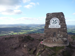
Trig Point with Views, The Skirrid/Ysgyryd Fawr
SWC Walk 347 - Llanvihangel Crucorney Circular (via Bryn Arw and The Skirrid)
Sep-19 • thomasgrabow on Flickr
swcwalks swcwalk347 walkicon 49012724102
Backview of Prow of The Skirrid (landslip on right-hand side)
SWC Walk 347 - Llanvihangel Crucorney Circular (via Bryn Arw and The Skirrid)
Sep-19 • thomasgrabow on Flickr
swcwalks swcwalk347 walkicon 49012515426

Barn at Llanvihangel Court
SWC Walk 347 - Llanvihangel Crucorney Circular (via Bryn Arw and The Skirrid)
Sep-19 • thomasgrabow on Flickr
swcwalks swcwalk347 walkicon 49012722147
| Length |
20.5 km (12.8 mi), with 783m ascent/descent. For a shorter walk see below Walk Options. |
|---|---|
| Toughness |
7 out of 10, with 5 ¾ hours walking time. For the whole outing, including trains, sights and meals, allow at least 12 hours. |
| Walk Notes |
This walk in the south eastern corner of the Brecon Beacons National Park combines two more-than-a-kilometre long unchallenging ridge walks, offering fantastic views of the surrounding Black Mountains’ hills and the Monmouthshire plain, with some quiet pastures with views as well as scenic wooded valleys, gushing spring-fed streams and a Michelin-starred lunch pub. From Llanvihangel Crucorney you cross the Honddu River and ascend through pastures half-way up a hill to re-cross the river and ascend the three-topped Bryn Arw on narrow paths through its bracken-covered slopes. The ridge itself is straight as an arrow and the three tops hardly distinguishable, but the views are superb. Descend steeply into the Cwmbrynarw and follow a spring-fed stream to the Gavenny River and go up along the flanks of The Skirrid to its southerly base. Comparatively, The Skirrid isn’t a massive mountain, but it rises high above the surrounding plain and offers one of the most rewarding ridge walks in South Britain along its 1 km spine to the highest point of the mountain, with its trig point and remains of an Iron Age hillfort and a Roman Catholic chapel. From here you have fantastic panoramic views of most of the Brecon Beacons’ Central and Eastern hills.
Shorter walks, starting from or finishing in Abergavenny, are possible. |
| Walk Options |
Start (map-led) from Abergavenny Station direct to the bottom of The Skirrid (cut 5.3 km/3.3 mi), or to the lunch options Copper Kettle Tea Room (cut 6.2 km/3.9 mi) or The Walnut Tree Inn (cut 7.1 km/4.4 mi). Have picnic lunch, cut out the out-and-back to both lunch places (cut 3.3 km/2.0 mi).
Finish (map-led) in Abergavenny direct from the bottom of the ascent of The Skirrid (cut 600m), or from the lunch options the Copper Kettle Tea Room (cut 1.5 km/0.9 mi) or The Walnut Tree Inn (cut 2.5 km/1.5 mi). A Variation of this Finish, going over Ysgyryd Fach instead of across a golf course and along the Gavenny River, is possible (add 920m to the Golf Course/Gavenny Ending). Car Drivers can walk an easy – if initially steep – out-and-back to the top of The Skirrid from the Skirrid Car Park on the B4521. |
| Maps |
OS Explorer Map: OL13 (Brecon Beacons National Park – Eastern Area)
|
| Travel |
Skirrid Inn Bus Stop, map reference SO 325 206, is 7 km north east of Abergavenny, 200 km west northwest of Charing Cross and 144m above sea level and in Monmouthshire, Wales. Llanvihangel Crucorney is served by line X3 (Cardiff - Abergavenny – Hereford) with 7 buses a day Mon-Sat only. Fares from/to Abergavenny are £3.20 single/£5.40 return (10/19). Saturday Walkers’ Club: This walk is doable as a daywalk from London, especially if you have motorised transport, but also if taking a train to Abergavenny to connect to above bus service. |
| Lunch |
The Copper Kettle Tea Room Em-Lee Llanddewi Skirrid, Abergavenny, Monmouthshire, NP7 8AP (01873 851 929). The Copper Kettle is located 11.5 km/7.1 mi into the walk.
|
| Tea |
The Skirrid Mountain Inn Skirrid View Llanvihangel Crucorney, Abergavenny, Monmouthshire, NP7 8DH (01873 890 258). The Skirrid Inn is located at the end of the walk. Wales’s oldest Inn. |
| Welsh Glossary |
aber: estuary, confluence, river mouth; afon: river; affwys: abyss; allt: hillside, cliff; aran: high place; ban/fan/bannau (pl): peak/beacon/crest, hill/mountain; big: peak; blaen: source of river, head of valley; bod: dwelling; bre: hill; bron: hill-breast; bryn: hill; bwlch: gap/col/pass; cadair: chair; cae: field; caer/gaer: stronghold, fort; capel: chapel; carn/garn/carnedd/garnedd: cairn, heap of stones, tumulus; carreg/garreg: stone, rock; castell: castle; cefn: ridge, hillside; celli: grove/copse; cerwyn: pot-hole; cist: chest; clog/clogwyn: cliff; clun: meadow; clwyd: hurdle/gate; clydach: torrent; coch/goch: red; coed: wood; craig/graig: rock; crib/cribyn: crest, ridge, summit; crug: mound; cul: narrow; cwm: hanging valley/corrie/bowl/dale; cyfrwy: ridge between two summits (saddle); ddinas: fort; dibyn: steep slope, precipice; dim: no; din: hill-fortress; disgwylfa: place of observation, look-out point; dôl: meadow; du/ddu: black, dark; dwfr/dŵr: water; dyffryn: valley; -dyn: fortified enclosure; eglwys: church; eira: snow; eisteddfod: meeting-place, assembly; esgair: ridge; fach/bach: small; fawr/mawr: large; fechan: smaller; ffald: sheep-fold, pound, pen, run; ffordd: way, road; ffridd: pasture; ffrwd: stream, torrent; ffynnon: spring/well; gallt: wooded hill; ganol: middle; garth: promontory, hill, enclosure; glan/lan: river-bank, hillock; glas: green (when referring to grass, pasture or leaves), blue (when relating to the sea or air); glyn: deep valley, glen; gors: bog; gorsedd: tumulus, barrow, hillock; gwyddfa: mound, tumulus; gwylfa: look-out point; gwyn/gwen: white; gwynt: wind; hafn: gorge, ravine; hafod: summer dwelling; hen: old; hendre(f): winter dwelling, old home, permanent abode; heol: road; hesgyn: bog; hir: long; is: below, lower; isaf: lower/lowest; llan: church, monastery; llawr: level area, floor of valley; llech: slab, stone, rock; llther: slope; lluest: shieling, cottage, hut; llwch: lake, dust; llwybr: path; llwyd: grey, brown; llwyn: bush, grove; llyn: lake; llynwyn: pool/puddle, moat; maen: stone; maes: open field, plain; mawn: peat; mawnog: peat-bog; melyn: yellow; merthyr: burial place, church; moel/foel: bare, bald/bare hill; mynydd: mountain, moorland; nant: brook/stream, dingle/glen; neuadd: hall; newydd: new; ogof/gogof: cave; pant: hollow; parc: park, field, enclosure; pen: head, top/end, edge; penrhyn: promontory; pentre(f): homestead, village; perfedd: middle; perth: bush, brake, hedge; plas: hall, mansion; pont/bont: bridge; porth: gate/gateway, harbour/bay/landing-place/ferry; pwll: pit, pool; rhiw: hill, slope; rhos: moor, promontory; rhudd: red, crimson; rhyd: ford; sarn: causeway; sgwd/rhaeadr: waterfall; sticill: stile; sych: dry; tafarn: tavern; tâl: end, top; talar: headland (of field); tan/dan: below; tarren/darren: escarpment; tir: land, territory; tor: break, gap; tre/tref: settlement, hamlet, town; twlch: tump, knoll; twll: hole, pit; tŵr: tower; twyn: hill; tŷ: house; uchaf: upper, highest; uwch: above, over; waun/gwaun: moorland, meadow; wen/wyn: white; y, yr, ‘r: the; ynys: island, holm, river-meadow; ysgol: ladder, formation on mountain-side/school; ysgwydd: shoulder (of mountain); ystafell: chamber, hiding-place; ystrad: wide valley, holm, river-meadow. |
|---|---|
| Profile | |
| Help Us! |
After the walk, please leave a comment, it really helps. Thanks! You can also upload photos to the SWC Group on Flickr (upload your photos) and videos to Youtube. This walk's tags are: |
| By Car |
Start Llanvihangel Crucorney Abergavenny NP7 8DH Map Directions |
| Amazon | |
| Help |
National Rail: 03457 48 49 50 • Traveline (bus times): 0871 200 22 33 (12p/min) • TFL (London) : 0343 222 1234 |
| Version |
Apr-24 Thomas G |
| Copyright | © Saturday Walkers Club. All Rights Reserved. No commercial use. No copying. No derivatives. Free with attribution for one time non-commercial use only. www.walkingclub.org.uk/site/license.shtml |


Walk Directions
Full directions for this walk are in a PDF file (link above) which you can print, or download on to a Kindle, tablet, or smartphone.
This is just the introduction. This walk's detailed directions are in a PDF available from wwww.walkingclub.org.uk