Lymington to Barton-on-Sea walk
Easy coastal walk along the Solent Way with views towards the Isle of Wight. Return by bus.
| Length | 15.7 km (9.8 miles) |
|---|---|
| OS Map | Landranger 196, Explorer 22 |
| Toughness | 2 out of 10. |
| Features |
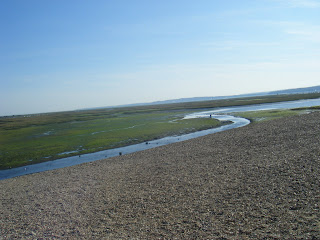
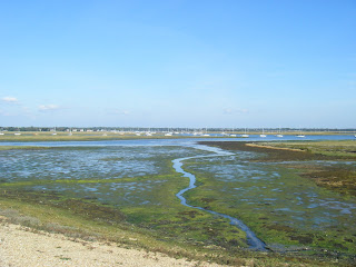
A delightful and varied coastal walk starting at the attractive seaside town of Lymington in the New Forest. Passing by the colourful Quay and yacht basin, the route joins the Solent Way which winds through tranquil salt marshes and a nature reserve where many different types of birds and wildflowers can be spotted. After lunch there is a short amount of esplanade walking followed by a very gentle cliff top path with fine views of the Needles and the Isle of Wight. Tea is at the Beachcomber café which has a lawned outside seating area overlooking the sea. This is an easy, fairly flat walk and the directions are straightforward and consequently minimal. |
| Walk Options |
You can walk out-and-back to Hurst Castle along a spit out in to the sea between the Solent and the Isle of White with commanding views. You can also catch a ferry from Keyhaven harbour, and walk back along the spit. You can walk from Barton-on-Sea to New Milton station, rather than waiting for the bus which doesn't connect with the train. Its about 1.5 miles extra. You could equally well do this walk in reverse, and explore the hidden coast between Barton-on-Sea and Milford-on-Sea. |
| Swimming |
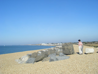
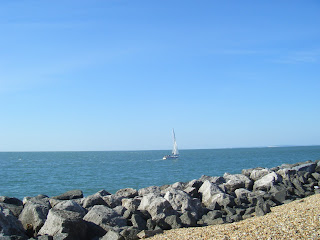
There are excellent swimming opportunities all along the stretch of coast from the Needles café (possible lunch stop) onwards. However the very best spot for a swim if you like sandy beaches is right at the end. Take the wide sloping concrete path down to the beach, just to the left of the Beachcomber café and turn right once you reach the beach. After following the shoreline for 400m and two breakwaters you will find a half sandy beach i.e. pebble bank and sandy shore below. Further beyond is rather spectacularly situated cliff top café with panoramic views. |
| Travel |
Take a train from London Waterloo (change Brokenhurst) to Lymington Town (i.e. Not Lymington Pier) (takes 1hr 45 mins, 2 trains an hour). Return from New Milton Station takes 1hr 30 mins, but only 1 fast train an hour. Buy a return to Lymington Town. Suggested train: nearest to 9.30am (before or after) from Waterloo. See below for the Barton-on-Sea to New Milton bus. If doing this walk by car, bus X1 runs from Barton-on-Sea to Lymnington. As always, it better to do the bus journey first, and walk back to your car |
| Lunch |
The Gun Inn, Keyhaven Rd, Keyhaven SO41 0TP, (tel 01590 642391) Located 8.2 km from the start of the walk. This is the pub lunch stop. Its just back from the coast after the yacht club car park. Mixed internet reviews: quick service, OK food, pricy, real ales The Marine large art deco cafe bar just behind the coast path in Milford, 10km from the start. Try the roof terrace - the ground floor cafe doesn't have a sea view. The Needles Eye Café, Hurst Road, Milford-on-Sea, SO41 0PY (tel 01590-642458). Recommended, on the promenade about 100m after The Marine (white art deco building). This is a possible lunch stop, located 10km from the start of the walk. |
| Tea |
Beachcomber Café, Marine Drive, Barton-on-Sea, BH25 7DZ (tel 01425 611599). This the suggested tea stop. The Pebble Beach, Marine Drive, Barton-on-Sea, BH25 7DZ (tel 01425-627777). This is a possible tea stop. There is also overnight accommodation here if you want to make a weekend of it and walk the next stretch of coast to Bournemouth the following day. |
| Links |
|
| Status | Full revised July 2014 |
| Barton-on-sea |
New Milton Station is 2.5 km/1.5 miles inland from Barton-on-Sea. You can walk, or take a short bus ride. There is a pub, and a supermarket just south of the station. At the time of writing [Aug-2014], the buses don't link well with the trains. Bus X1 runs: Monday - Saturday: xx:36, then 19:24, 20:25 (the xx:36 buses miss the hourly train, but the last 2 connect). Sunday: 16:39, 18:39 Check bus times online Traveline SouthWest If doing this walk by car, bus X1 runs from Bournemouth to Barton-on-Sea to Lymnington. As always, it better to park at the end, do the bus journey, and then walk to your car |
|---|---|
| Profile | |
| Help Us! |
After the walk, please leave a comment, it really helps. Thanks! You can also upload photos to the SWC Group on Flickr (upload your photos) and videos to Youtube. This walk's tags are: |
| By Train |
Out (not a train station) |
| By Car |
Start SO41 9AZ Map Directions Finish Marine Drive, Barton On Sea, New Milton, Hampshire BH25 Map Directions |
| Amazon | |
| Help |
National Rail: 03457 48 49 50 • Traveline (bus times): 0871 200 22 33 (12p/min) • TFL (London) : 0343 222 1234 |
| Version |
Apr-24 Penny |
| Copyright | © Saturday Walkers Club. All Rights Reserved. No commercial use. No copying. No derivatives. Free with attribution for one time non-commercial use only. www.walkingclub.org.uk/site/license.shtml |


Walk Directions
- Coming out of the main entrance of Lymington Town station, turn left (Mill Lane). Pass a marina on your left and in 150m you suddenly come out by the Quay, next to the river, with a view of moored yachts and the railway bridge. There is a nice pub, The Ship Inn, to your right with a river view terrace for a coffee.
- On the north west corner of the Quay is a small pedestrian lane, follow it for 50m to the main shopping street if you need a picnic
- Follow Quay Road south past public toilets, which becomes Bath Road, for 400m. It runs parallel to the river, but with no view, passing Marinas on your left hand side.
- After the marinas, turn left into a city park and follow the riverside path. Pass a large lido (outdoors swimming pool) on your right.
- Continue south, passing through a marina (Walk past a small building, then south alongside the harbour basin, then east still along side it.
- Leaving the harbour basin behind, follow the riverside path alongside the salt marshes with pretty wildflowers.
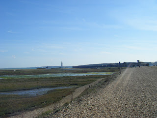
- Keep to the sea wall. Eventually after 1.5 km, you pass along a narrow path, with the sea to your left, and a large lake on your right with a sailing club. Keep to the coast for a futrher 500m until you cross a small bridge
- Either head back to the coast and follow the sea wall, or in 2104, there was a short cut to avoid a closed path - follow the diversion signs - southwest for 100m then south until you rejoin the sea wall.
- There is a swimming spot here. Follow the sea now, southwest. Pass a jetty (swimming spot). After 2km you reach Keyhaven village.
- Just after walking through a car park (slightly away from the coast), The Gun Inn is a possible pub lunch stop. (After lunch turn right upon leaving the pub to rejoin the Solent Way.)
- Continue along the coastal path for 1km to reach a large shingle back.
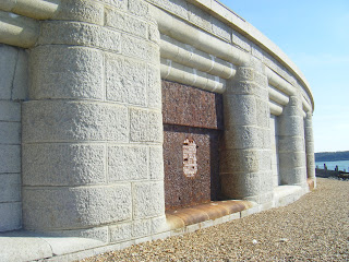
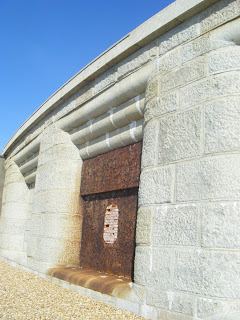
- You can walk out to Hurst Castle (2km out and 2km back, or there are ferries from Newhaven village). Its a Victorian fort run by Enlish Heritage, with a cafe. There are lovely views.
- Continue west for 1km, you join a promenade. Pass the large Marina Cafe, and soon after, the Needles Eye Café (on the seafront path), an alternative lunch stop. Anywhere here is a swimming spot.
- You now join a cliff path along the top of low cliffs which are suffering erosion. There are occasional ways down to the little used sandy beach below. The area is used by naturists.
- After 5.5km until you reach the cliff top Beachcomber Café in New Milton.
- Just before it there is a path down to the beach. Turn right at the bottom for 400m for a good swimming spot.
- From here you may catch the bus (at the stop on the opposite side of the road to The Pebble Beach) to New Milton (and on to Lymington).
- Otherwise, you can walk. New Milton station is just over 2.5km/1.5 miles inland so 30 mins brisk walking, or 45 at a more gentle pace. Leave more time if you want to pop into a shop for supplies for the journey home.
- With the entrance to The Pebble Beach behind you, cross the coast road to go along Barton Court Avenue, your direction 10° (almost due north).
- After 1.2km at a junction with Lymington Road (A337) by a Lidl, go straight on (now Barton Court Road).
- At the end, turn left on to Station Road. Go Straight on at a junction, pass a pub and some supermarkets to reach New Milton Station on your left. You need to cross over the footbridge for London