Macclesfield Circular via The Dane Valley walk
The Dane Valley, pastures and wooded valleys, and ridges with views of the Cheshire Plain, high moors and gritstone ridges
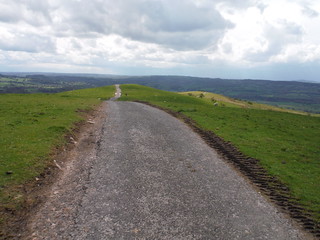
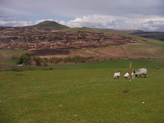
Wincle Minn: the view ahead
SWC Walk 381 - Macclesfield Circular (via the Dane Valley)
May-21 • thomasgrabow on Flickr
swcwalks swcwalk381 banner 51329722038
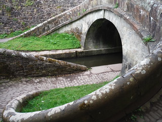
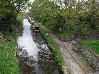
Macclesfield Canal, Canal Bridge #43, the Roving Bridge, from the East
SWC Walk 381 - Macclesfield Circular (via the Dane Valley)
May-21 • thomasgrabow on Flickr
swcwalks swcwalk381 walkicon 51330232194
Shutlingsloe and the High Moors beyond, from descent off Croker Hill
SWC Walk 381 - Macclesfield Circular (via the Dane Valley)
May-21 • thomasgrabow on Flickr
swcwalks swcwalk381 walkicon 51329513511

Bosley Cloud from bench on Wincle Minn
SWC Walk 381 - Macclesfield Circular (via the Dane Valley)
May-21 • thomasgrabow on Flickr
swcwalks swcwalk381 walkicon 51329722103
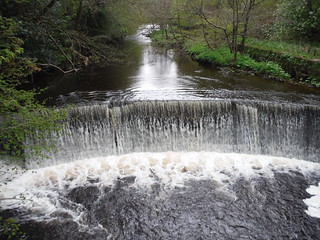
Weir on River Dane, from footbridge by Gig Hall
SWC Walk 381 - Macclesfield Circular (via the Dane Valley)
May-21 • thomasgrabow on Flickr
swcwalks swcwalk381 walkicon 51328776752
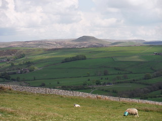
Sheep, Shutlingsloe, Mount Pleasant and Axe Edge Moor, from Cessbank Common
SWC Walk 381 - Macclesfield Circular (via the Dane Valley)
May-21 • thomasgrabow on Flickr
swcwalks swcwalk381 walkicon 51329720398
Macclesfield Canal from Windmilll Street, westbound
SWC Walk 381 - Macclesfield Circular (via the Dane Valley)
May-21 • thomasgrabow on Flickr
swcwalks swcwalk381 51329720208
| Length |
28.9 km (18.0 mi), with 735m ascent/descent. For a longer or shorter walk see below Walk Options. |
|---|---|
| Toughness |
8 out of 10, with 7 ½ hours walking time. |
| Walk Notes |
Varied walk, through pastures and wooded valleys and along some ridges, with many fascinating views of the Cheshire Plain and across to the surrounding high moors and gritstone ridges in the westerly Dark Peak area. Leave the town along a section of the Macclesfield Canal with its Roving Bridge and up along the Bollin River valley onto Ridge Hill and continue through rolling pastures and up onto Croker Hill, the ridge separating the pastoral landscapes of wooded valleys and grazing pastures of the westerly Peak District from the Cheshire Plain. After a short descent, you follow the Gritstone Trail up to and along the Wincle Minn (ridge) – or alternatively through the tight wooded Greasley Hollow part of the Shell Brook valley – to then follow an enchanting stretch of the Dane Valley upstream (shorter and longer options come into play around here) for lunch in Wincle.
Several walk options make for a variety of shorter, longer, higher and lower routes. |
| Walk Options |
Bus Line 14 (Macclesfield – Langley, about hourly Mon-Fri, every two hours Sat) enables a start in Sutton Lane Ends (cut 3.1 km and 60m ascent). From Macclesfield, alight at the Church House stop in Sutton Lane Ends. Walk back for about 100m to a four-way road junction by the Church House Inn opposite on the left and pick up the directions on page 5 at the single asterisk *).
|
| Maps |
OS Explorer: 268 (Wilmslow, Macclesfield & Congleton) – just for the urban start – andOL24 (The Peak District – White Peak Area)
|
| Travel |
Macclesfield Station, map reference SJ 919 736, is 237 km northwest of Charing Cross, 133m above sea level and in Cheshire East. It is on the Stafford to Manchester branch line off the West Coast Main Line from London Euston. Travel time from London is from 101 minutes Mon-Sat, but 2 ¼ hours on Sundays. Saturday Walkers’ Club: The walk is doable as a daywalk from London with a train no later than 09.20 hours. |
| Elevenses |
Ye Olde King’s Head 30 Bradley Smithy, Gurnett, Macclesfield, Cheshire, SK11 0HB (01625 611 444). Located 2.4 km into the walk.
|
| Lunch |
Wincle Beer Company Tolls Farm Barn, Dane Bridge, Wincle, Macclesfield, Cheshire, SK11 0QE (01260 227 777). Wincle Beer is located 17.2 km (10.7 mi) into the walk, on the banks of the Dane.
|
| Tea |
The Rose and Crown Buxton Road, Allgreave, Macclesfield, Cheshire, SK11 0BJ (01260 227 232). The Rose & Crown Inn is located 580m off-route, 10.8 km (6.7 mi) from the end of the walk.
|
| Profile | |
|---|---|
| Help Us! |
After the walk, please leave a comment, it really helps. Thanks! You can also upload photos to the SWC Group on Flickr (upload your photos) and videos to Youtube. This walk's tags are: |
| By Train |
Out (not a train station) Back (not a train station) |
| By Car |
Start SK11 6JP Map Directions |
| Amazon | |
| Help |
National Rail: 03457 48 49 50 • Traveline (bus times): 0871 200 22 33 (12p/min) • TFL (London) : 0343 222 1234 |
| Version |
Apr-24 Thomas G |
| Copyright | © Saturday Walkers Club. All Rights Reserved. No commercial use. No copying. No derivatives. Free with attribution for one time non-commercial use only. www.walkingclub.org.uk/site/license.shtml |

Walk Directions
Full directions for this walk are in a PDF file (link above) which you can print, or download on to a Kindle, tablet, or smartphone.
This is just the introduction. This walk's detailed directions are in a PDF available from wwww.walkingclub.org.uk