Marlborough Circular via Avebury Walk
Over the Marlborough Downs and through sarsen fields to the Avebury World Heritage Site

The Cove, Avebury, NE quartile
SWC Walk 354 Marlborough Circular via Avebury
Jun-22 • thomasgrabow on Flickr
swcwalks swcwalk354 banner 52155260183
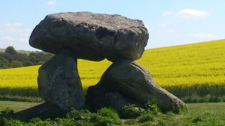
Devil's Den, from the northwest
SWC Walk 354 Marlborough Circular via Avebury
Apr-17 • thomasgrabow on Flickr
swcwalks swcwalk354 walkicon 34239185955
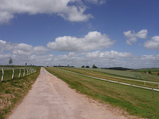
Backview along bridleway between gallops on Barton Down, Manton Park
SWC Walk 354 Marlborough Circular via Avebury
Jun-22 • thomasgrabow on Flickr
swcwalks swcwalk354 walkicon 52154239972

Sarsens, grass, buttercups: Fyfield Down NNR
SWC Walk 354 Marlborough Circular via Avebury
Jun-22 • thomasgrabow on Flickr
swcwalks swcwalk354 walkicon 52155747080

Marlborough, Town Hall
SWC Walk 354 Marlborough Circular via Avebury
Jun-22 • thomasgrabow on Flickr
swcwalks swcwalk354 52154239502
| Length |
24.2 km (15.0 mi), with 297m ascent/descent. For a shorter or a longer walk, see below Walk Options. |
|---|---|
| Toughness |
5 out of 10, with 5 ½ hours walking time. For the whole outing, including trains, sights and meals, allow at least 9 ½ hours. |
| Walk Notes |
This is a fascinating excursion into the heart of Neolithic Wiltshire, a mysterious landscape full of pre-historic earthworks, standing stones, sarsen fields and barrows – burial mounds of kings and warriors. The route passes through two of the most important prehistoric sites in Britain: Avebury Standing Stones and Bank & Ditch Earthworks and Fyfield Down Sarsen Stones Field. Other significant sites nearby (Silbury Hill, West Kennett Long Barrow, The Sanctuary and Windmill Hill) can be explored on extension loops. You walk out of the historic market town of Marlborough with its extra-wide High Street onto the Marlborough Downs, passing some horse gallops of the famous Manton Park stud and go through some small and medium-sized fields scattered with sarsen stones. Briefly follow the Ridgeway and turn down it scenically to Avebury, where the route passes all notable features within the village boundary, as well as a short stretch of the West Kennett Avenue of Standing Stones.
|
| Walk Options |
Buses 42 and 49 serve Avebury, enabling a start or finish there:
Two Extension Loops from Avebury village to outlying sites are possible:
|
| Accommodation in or near Avebury |
Avebury Lodge High Street, Avebury (01672 539 023)
|
| Maps |
OS Landranger Map: 173 (Swindon & Devizes)
|
| Travel |
Marlborough, Ladbrokes bus stop is served by lines 20 and 22 from Bedwyn Station or from the nearby Great Bedwyn Square. The buses stopping at the station will wait for up to 10 minutes for a delayed train. A valid train ticket reduces the cost of the bus to £1.30 each way [06/2022]. There is also the occasional Express Bus X22 from Hungerford Library (Mon-Sat, 5 minutes from the Station), which may offer a connection from the train when Bedwyn doesn’t. Bedwyn and Hungerford Stations are on the Berkshire and Hampshire line from London Paddington. The journey times are from 50 minutes to Hungerford and from 65 minutes to Bedwyn. Saturday Walkers’ Club: Take the train closest to 09.00 hours. |
| Lunch |
Circles Restaurant Avebury, Marlborough, Wiltshire, SN8 1RF (01672 539 250). The Circles is located 11.2 km (7.0 mi) into the walk.
|
| Tea |
The Oddfellows 71 High Street, Manton, Marlborough, Wiltshire, SN8 4HW (01672 512 352). The Oddfellows is located 2.4 km from the end of the walk. Open all day every day.
|
| Profile | |
|---|---|
| Help Us! |
After the walk, please leave a comment, it really helps. Thanks! You can also upload photos to the SWC Group on Flickr (upload your photos) and videos to Youtube. This walk's tags are: |
| By Car |
Start Map Directions |
| Amazon | |
| Help |
National Rail: 03457 48 49 50 • Traveline (bus times): 0871 200 22 33 (12p/min) • TFL (London) : 0343 222 1234 |
| Version |
Oct-23 Thomas G |
| Copyright | © Saturday Walkers Club. All Rights Reserved. No commercial use. No copying. No derivatives. Free with attribution for one time non-commercial use only. www.walkingclub.org.uk/site/license.shtml |

Walk Directions
Full directions for this walk are in a PDF file (link above) which you can print, or download on to a Kindle, tablet, or smartphone.
This is just the introduction. This walk's detailed directions are in a PDF available from wwww.walkingclub.org.uk