Milford to Haslemere walk
Its surprising how remote Surrey can be, pretty lakes, heathland, and Devil's Punchbowl as well.

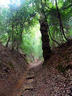
Thorsley Common in August
Milford to Haslemere walk
Aug-14 • Saturdaywalker on Flickr
book1 walkicon swcwalks walk27 15104195696


The course of the old A3
Milford to Haslemere walk
Aug-14 • Saturdaywalker on Flickr
book1 walkicon swcwalks walk27 15104190126


Thursley, Hindhead & the Devil's Punch Bowl
| Length |
19.09km (11.86 miles), 5 hours 15 minutes. For the whole outing, including trains, sights and meals, allow at least 9 hours. |
|---|---|
| Toughness |
6 out of 10. |
| OS Maps |
Explorers OL33 (was 133) & 145 or Landranger 186. Milford, map reference SU 955 414, is in Surrey, 3 km south-west of Godalming. |
| Features |
This is a lovely walk, with remote heathland and some pretty lakes in the morning, and Devil's Punchbowl and Gibbet Hill in the afternoon. Good in high summer, as in the woodland you have trees for shade, and in late July and August, the heather on the Commons is a sea of purple. The walk starts with a long stretch on a narrow pavement to a road out through Milford. A qieter alternative start (also on roads) has been added to the Directions. You are soon rewarded for the start by the beauty of the landscape beyond. Bagmoor Common Nature Reserve’s heathland of purple moss grass and heather, and woodland of oaks and Scots pine, leads on to the lakes of Warren Mere and across to the village of Thursley which has a fine old church and your lunchtime pub, the Three Horseshoes. Mainly you are walking through National Trust land, sandy bridleways through ancient established woodlands and the heather, gorse and bilberry of the heathland. Thursley Common suffered from a major fire in 2006, leaving a burnt-out moonscape. Thankfully, the Common has recovered very well, with the return of heather and gorse, although evidence of the devastating fire can be seen to this day by the burnt bark on some trees which survived. After walking through the Devil’s Punch Bowl, now wonderfully devoid of traffic noise since the A3 Hindhead tunnel opened in summer 2011, you ascend to its café, for a late lunch or an early tea stop. From there, if not taking the recommended out-and-back option to Gibbet Hill and Sailor’s Stone, you follow the Greensand Way with fine views out towards the South Downs, with finally a footpath into the High Street in Haslemere for tea. This walk can be walked in winter as the sandy commons remain relatively mud-free. However, in winter you do not totally escape mud as the bridleways through woodland tend to be very muddy, and the sunken path which heads uphill from Lower Ridgeway Farm to Hindhead Common above the Devil's Punch Bowl can be ankle deep in mud - so do wear appropriate footwear. Most SWC walks are as enjoyable when walked alone as they are when walked in the company of a group of walkers. However, due to the remoteness and bleakness of the commons in the morning leg of the walk, this walk is eerily lonely for the solitary walker, so it is best walked in company. |
| Walk Options |
Keeping to the Punch Bowl's Rim After lunch, instead of descending down to the valley of the Punch Bowl, then climbing steeply back out of it, this route contours along the rim, with a fine view; this route is shorter in distance and a lot easier. Gibbet Hill and Sailor’s Stone After tea at the NT café, instead of going through the next valley this alternative follows the rim instead, visiting the summit of Gibbet Hill (viewpoint) and the Sailors Stone memorial; again this is easier than the main route (you've gained most of the height already), although slightly longer in distance. It's the NT Blue trail. Shortening the Walk You could order a taxi from Thursley or you could catch a bus near the cafe in Hindhead. |
| History |
The Church of St Michael and All Angels, Thursley, has heavy-duty wooden roof beams, added in Henry VII’s time to support a new tower. Its Saxon windows up by the altar on the north wall are the only ones in England with their original timber frames (thin horn or oiled linen was used for window panes). Note also the embroidered kneelers in the pews. The graveyard is a nice spot for a picnic with a bench and a nice view. Legend has it that the Devil’s Punch Bowl was formed when the Devil scooped up earth to hurl at Thor, the God of Thunder, who lived in Thor’s Lie (Thursley); the punch bowl refers to the mist that seems to flow over the rim of the bowl. The heathlands here were among the UK’s earliest cultivated areas, clearings in the forest that were abandoned as the nutrients leached away into the sandy soil. The spring line between the sandstone top layer and the impermeable clay beneath led to erosion of the sandstone, thus creating the Devil’s Punch Bowl. An unknown sailor returning to his ship in Portsmouth bought drinks for three men at a (closed) pub in Thursley on 24th September 1786. Later, they murded him near the Devil’s Punch Bowl. Found guilty, they were hanged in chains on the hill nearby, now known as Gibbet Hill. The outraged and doleful headstone erected for the sailor can be read in the north-west edge of Thursley churchyard. There is also a memorial to the sailor, Sailor’s Stone, on the way to the hill: In memory of; A generous but unfortunate Sailor; Who was barbarously murder'd on Hindhead; On September 24th 1786; By three Villains; After he had liberally treated them; And promised them his farther assistance; On the road to Portsmouth. The A3 used to climb one rim of Gibbet Hill and pass the NT visitor centre. It is now buried in a very expensive tunnel. The former route has been grassed over. Now the NT tea room is at the end of a cul-de-sac, and Hindhead is a quiet village. The NT, who own the surrounding countryside, has a friends group - Friends of Black Down and Hindhead Only the tower of St Bartholomew’s Church in Haslemere is ancient, the rest having been boldly demolished by the Victorians. There is a stained glass window here dedicated to the poet Tennyson. In Tudor and Stuart times Haslemere was a centre for the iron industry. With the coming of the railway in the mid-nineteenth century it became a popular spot for literary people. Tennyson’s house, Aldworth, is on the slopes of Black Down where he loved to walk; and the novelist George Eliot wrote Middlemarch in Shottermill. The town has an interesting museum up the High Street, just north of Darnleys tearoom. The museum is open 10.00 am to 5.00 pm Tuesday to Saturday, and has important natural history collections. Other highlights include an Egyptian mummy, Zulu beadwork and Eastern European peasant art plus a fine explanatory display of local wild flowers in the foyer. |
| Travel |
Take the train nearest to 10.00am from Waterloo Station to Milford (Surrey). Journey time 50 minutes. There are up to four trains an hour back from Haslemere. Journey time 50-60 minutes. Buy a day return to Haslemere. By car: Milford Station has a pay car park. There are a few free places on the road, or park a few hundred yards along the route in Milford village. There are direct trains back from Haslemere (10 mins, 1 an hour) |
| Lunch |
Your lunchtime stop on this walk is the community owned Three Horseshoes "pub with good food" in Thursley (tel. 01252 703900), some 7.9 km into the walk, which has an informal eating area and restaurant inside the pub plus extensive seating outdoors in the attractive beer garden. Closed Mondays and Tuesdays (as of Spring 2024) Lunch is served Wednesday to Friday from 12 noon until 2 pm, and on Saturday and Sunday from 12 noon until 2.30 pm. The menu extends to starters and light bites, main courses, pub favourites, homemade pizzas, and wraps and sandwiches. On most Sundays classic roasts are served. There is a Nisa Local convenience store near the start (or at the Farmer’s Market close by) - you could picnic by the lake mentioned in the walk directions. |
| Tea Break |
In Hindhead, The National Trust’s Devil’s Punch Bowl Café (tel. 01428 606565) serves as an early tea stop and is open until 5pm. There are also some outside picnic tables. Near the NT car park entrance is the Devil’s Punchbowl Hotel (tel. 01428 606565) which has a bar, and on Sundays has a carvery open until 5.15pm. [!] Allow 80 minutes walking time from here to Haslemere railway station. |
| Updates |
This edition August 2022. [All editions] Nature has repaired the devastating fire on the heathland near the start. [Older editions] The A3 Hindhead tunnel has opened. Hindhead is now a quiet village, and the former main road is a cycle path. No major changes to the route however, but the Punch Bowl is now much quieter. Darnleys reopening after refurbishment added December 2020. Lunch pub update May 2024. |
| Book |
This walk was originally published in Time Out Country Walks near London volume 1. We now recommend using this online version as the book is dated. The book contained 53 walks, 1 for every week of the year and 1 to spare. Here is our suggested schedule |
|---|---|
| Tea |
Haslemere town centre (about 10 mins walks from the station)
Haslemere station
|
| Profile | |
| Help Us! |
After the walk, please leave a comment, it really helps. Thanks! You can also upload photos to the SWC Group on Flickr (upload your photos) and videos to Youtube. This walk's tags are: |
| By Train |
Out (not a train station) Back (not a train station) |
| By Car |
Start GU8 5AD Map Directions Return to the start: Finish GU27 2PD Map Directions Travel to the start: |
| Amazon | |
| Help |
National Rail: 03457 48 49 50 • Traveline (bus times): 0871 200 22 33 (12p/min) • TFL (London) : 0343 222 1234 |
| Version |
May-24 Marcus |
| Copyright | © Saturday Walkers Club. All Rights Reserved. No commercial use. No copying. No derivatives. Free with attribution for one time non-commercial use only. www.walkingclub.org.uk/site/license.shtml |


Walk Directions
- [1] Coming off platform 2 at Milford Railway Station, exit by the grey metal gate and cross over the railway line at the level crossing (or use the footbridge) to continue on a tarmac road, your direction 345°, passing the railway station building on your right-hand side.
- Here you have a choice, the original route with a 1km walk along a narrow pavement, or a quieter alternative
- Original Route
- Keep on the road, ignoring all ways off, as you head towards the village of Milford, passing Milford Golf Club on your way, with golf links either side of the road.
- In just over 1km at the T-junction, go right and in 10 metres, at the mini roundabout, go left on the main road (Portsmouth Road) signposted Guildford, with a Nisa Local convenience store on the corner to your left. (NB Straight on from the mini-roundabout is a Tesco Express)
- Ignore all ways off as you walk through Milford, going past Milford Village Hall on your left and a Farmer’s Market on your right. In 450 metres, at the traffic light T-junction, where right is signposted to Guildford, cross before going left (taking care as there is no pedestrian crossing), your direction now 230°.
- In 50 metres you go right on Lower Moushill Lane. In a further 225 metres, you pass Moushill Court on your left-hand side.
- Stay on this tarmac lane through its bends and ignore all ways off (including signposted footpaths and bridleways to your left and right) and in 170 metres you pass Chimneys House.
- New Quieter Start
- In 50m, turn left on Rake Lane, and follow it for 500m. Towards the end, fork right over some common land towards a main road.
- Turn right on Petworth Way / A283 and in 120m, turn left on Milford Heath Road
- Pass a Cricket Pitch. Cross Haslemere Road / A286 to continue ahead on Moushill Lane.
- Turn left for 20m on A283 Portsmouth Road, then turn right (i.e. crossing the main road) on a lane
- In 100m, go left at a fork, and in a further 100m, fork left on to Lower Mousehill Lane.
- Both routes continue
- Continue ahead on a bridge over the A3. Ignore the public footpath to the right, immediately on the other side of the bridge.
- In 100 metres, as the tarmac road becomes an earth road, follow the public bridleway sign straight on. In 70 metres you pass the entrance to Dairy Farm House on your right-hand side and in 25 metres, by a bridleway and footpath post, you take a fork to the right, a car-wide track that is a public footpath [2] your direction 300° initially.
- In 80 metres go over a stile on your right-hand side that has a yellow arrow on it (with a wooden fieldgate to its left) to continue straight on, along a car-wide earth track, initially gently downhill, along the fence of a house on your left-hand side, your direction 315°.
- In 225 metres go over two stiles, 2 metres apart (a metal fieldgate to their left)[!] but Note: the first stile is broken, March 2022) with a wooden pole pylon to your right. Follow the line of these pylons straight on, due west, along a narrow, fenced-in path between plantations of Christmas trees (Norway spruce).
- In 220 metres go over a stile to go through a potentially muddy area between streams and then ahead through a waterlogged field. In 130 metres go over a stile on a wooden bridge with wooden railings across a stream, and head into a grassy field.
- In 5 metres you come to a footpath post with yellow arrows. Take the path directly ahead over the grassy field with a house away to your right-hand side, ignoring the path off to the left, your direction west. In 80 metres you come to a sign welcoming you to Bagmoor Common Nature Reserve where you keep ahead, soon following the line of wooden pylons into the common.[3].
- Walk along this fern-bordered, narrow grassy pathway, as it meanders through the Common, at some times of year on ill-defined ways, following the occasional footpath post with yellow arrow, and with birch trees all around. In 500 metres you leave the nature reserve through a gap in a low, grass-covered earth bank, with more Bagmoor Common welcoming signs 40 metres over to your right, to continue on a path that follows the line of wooden pylons over to your right, avoiding any boggy bits as best you can.
- The next Direction assumes you have followed the footpath post arrows as aforementioned [as opposed to the Directions in the TO Book]. In 300 metres you come to a major cross paths, where turning right takes you in 45 metres to a tarmac road with a lake beyond. Cross over the path juntion and take the path ahead, slightly left, marked by a post with yellow and blue arrows, your direction 205° following the direction of the blue arrow .
- If you have followed the Directions in the TO Book you will come in 300 metres to a green sward where the line of pylons bears off to the right. Keep straight on here towards a tarmac road 50 metres further on, with a lake beyond. [4][!] At the road, turn 135° left to look back over the green sward, towards a footpath post with yellow and blue arrows, some 45 metres away, on a compass bearing of 170° [!] (There is another footpath post 4.5 metres to its left with one yellow arrow). Walk to the post with yellow and blue arrows which is at a path junction and here [!] bear right, following the direction of the blue arrow, 205°, along a bridleway, which soon has a drainage ditch on its right.
- Both Directions continue . In 200 metres the path swings to the right and in a further 80 metres, at a path crossing, you go under pylons, to keep ahead, through heather. In 10 metres cross a broad track and keep ahead, your direction due south, towards Thursley National Nature Reserve. Continue to follow blue arrows and ignore any ways off for 450 metres, your direction now 200°, along a sandy bridleway with drainage ditches over to the left and close by on your right, until you reach a clearing with an island of trees in the middle containing a Ministry of Defence training area warning notice and a Byelaws notice post.
- Go straight on - slightly left - for another 12 metres to a footpath post and a Welcome to Thursley National Nature Reserve notice board, to join a track coming in from the right. Now keep ahead, half left, down a slight dip and up the other side. In 180 metres you pass on your right-hand side a low, blue-topped post, and a path joins from the right. Go on down for another 85 metres to a footpath post with blue arrow and keep ahead slightly right, ignoring a bridleway off to the left through a wooden swing gate with on its right a metal fieldgate.
- In 160 metres, at a path junction, with a steel clad warehouse coloured green over to your left, fork right, your direction 220°, further into the pinewood.
- In 150 metres there is a lake 40 metres to your left. In 85 metres, for a pleasant detour to the lake, fork left, at a dip in the main path, your direction 165°, to walk beside the lake.
- In 190 metres, at the end of the lake and 25 metres before the end of the wood (marked by a fence line – with a house and lake some 250 metres away over to your left), you bear right with the path through fern, until in 65 metres you turn left to rejoin the bridleway, still with fencing over to your left-hand side, your direction 220°. In 75 metres bear left with the path, keeping beside fencing, and ignore a fork to the right.
- In 25 metres you pass under mini-pylons. In 15 metres, by a post to your left with a blue arrow on a white disc, fork right, your direction 215°.
- In 45 metres you come to a track junction (there is a house 30 metres to your left). Go right and in 20 metres, at a cross paths, with a post with blue bridleway arrows on your left, and with another "Welcome to Thursley National Nature Reserve" notice board 5 metres to your right, turn left on a car-wide earth track [5], your direction 190°.
- In 30 metres fork right, your direction 240°, following a blue arrow on a post. Follow this sandy bridleway, soon uphill, before it levels out, then heads gently downhill. For the next mile you walk through the area of heather, gorse and bracken which was devastated by fire in 2006, but thankfully now recovered.
- In detail: In 500 metres you come to a bridleway T-junction with a waymark post ahead. You turn left along a broad sandy track, your direction 155°, to keep on this main way, ignoring the fork first left in 2 metres.
- In 110 metres [6], and some 20 metres before the track swings gently to the left, by a gap in the gorse bushes on your right [!] turn right onto a sandy way, your direction 240 °, initially level but which soon gently descends. Ignore all minor ways off as you keep ahead and in 275 metres you start to go uphill.
- In 125 metres you are now in a sunken, sandy cutting as you head steeply uphill. In 100 metres at the top of the incline you pass the remnants of burnt out fire paddles on your left-hand side. Continue ahead, now on the level, on a broad track, with heather and gorse on either side, your direction 220°.
- In 400 metres, at a bridleway junction, with a footpath post directly ahead with blue bridleway arrows [!] bear left and in 6 metres cross a wide bridleway to go straight on, slightly to the right. In 15 metres pass to the left-hand side of a wooden fieldgate to go onwards, your direction 220 °.
- In 235 metres you come to a tarmac road T-junction (with the entrance to Foldsdown Cottage on your left-hand side). Here you go right to cross the road to the Three Horseshoes pub just along on the left-hand side, the suggested lunch stop.
- Coming out of the pub after lunch, turn left. In 80 metres, by the Old Vicarage, fork left on The Street. In 250 metres turn right on a signposted public footpath, an earth drive, leading towards Church Cottages, your direction due west.
- In 65 metres turn left, up a ramp with a wooden handrail, into the churchyard to visit the Church of St Michael and All Angels. Coming out of the church door, go straight on to exit the churchyard by the wooden swing gates (or over a stone step built into the wall, with a two-way footpath sign on its other side) to go right, uphill on the tarmac road, your direction 245°.
- In 15 metres you pass Hill Farm House on your right-hand side. Keeping to the left-hand side of the road, your pavement is parallel and above the road. In 100 metres go through a metal barrier and in a further 100 metres, rejoin the road.
- Keep ahead, gently uphill, and in a further 225 metres, you pass the entrance to Hill House Farm on your left-hand side. In 200 metres ignore a public footpath to the right by a sign for Hedge Farm.
- In 35 metres, at a bend in the road [7]branch right to take the signposted narrow footpath, your direction 250°, with a field fence on your left-hand side and a hedge on your right.
- In 220 metres, having zigzagged with the path (often overgrown with nettles in the summer), the path turns sharp right and in a further 80 metres you start to go steeply downhill. In 110 metres, having veered left with the path, go over a stile. In 25 metres, cross over an earth car track which heads down to a ford, pass between low wooden bollards and head down to turn right over a wooden bridge with wooden handrails over a stream. On its other side, turn left up a car-wide, rutted track, quite steeply uphill, your direction 225°. Soon this track is in a cutting.
- In 200 metres ignore a fieldgate opening to the left to go straight on along an earth farm track, now on the level. In 75 metres you pass Ridgeway Farm house (marked on the OS map), to continue on its tarmac driveway, now steadily downhill. In 135 metres, at a road junction with a sign to Upper Ridgeway Farm pointing to the right, turn left on a signposted public bridleway, your direction 175°. In 15 metres ignore an entrance through metal double fieldgates on your right. In a further 15 metres ignore a left turn and a wooden fieldgate on your left-hand side to keep straight on uphill on what soon becomes a sunken path, with woodland on either side. In winter this path can be very muddy.
- Ignore ways off as you progress uphill and in 440 metres you pass through a metal swing gate with a National Trust sign on your right. Continue ahead, still uphill, your direction now 190°.
- In 200 metres, as the path levels out, ignore a path to the left. In 125 metres, as the path swings to the right, ignore a fork to the left. In 10 metres, at a path crossing and by a post with multiple blue and other arrows [7A]
- Here you have a choice, descend into the Punch Bowl, or walk around its rim (slightly shorter in distance, and a lot easier).
- i) Main Walk: Down into the Punch Bowl
- Turn left, downhill, your direction 145°, keeping on this main way.
- In 12 metres ignore two ways off to the left as the path swings to the right. Your direction is now 185 °. In 300 metres you pass a bridleway down to the left by a part-timbered cottage. Keep ahead, your way now being a car-wide earth track.
- In 500 metres, go through a wooden fieldgate, ignore the second wooden fieldgate immediately on your left and take a kissing gate beside the third wooden fieldgate on your left [8] to go on a footpath steeply downhill, your direction 105°.
- In 75 metres go across a stream on a wooden bridge with wooden railings and go up the steps on the other side. In 100 metres, at the top, go through wooden posts and bear left, with Hindhead Youth Hostel off to your right. Continue uphill on a track with a ditch on your right-hand side, your direction 80°.
- In 100 metres join a tarmac lane coming in from your left to go straight on (slightly right), your direction now 100°.
- In 100 metres you come to the tarmac entrance driveway to a house on your right-hand side and carry on uphill, on a tarmac lane, which swings to the left. In 60 metres take a footpath fork off to the right by a post with one yellow and two red arrows on its top, next to a yellow grit and salt bin, your initial direction 185°.
- In 45 metres go through a wooden kissing gate (to the left of a wooden fieldgate). Keep to this main path for 800 metres as it meanders and undulates down into the Devil’s Punch Bowl, ignoring all ways off. This is blissfully quiet and devoid of the noise from the A3 now that this road has been rerouted through the Hindhead Tunnel. At the very bottom of the Bowl, with its western escarpment directly ahead, you come to a track junction [9] with a small stump on your left-hand side (its former markings long gone). [!] Here cross over the junction and bear a quarter right for 15 metres. [!] Now take the left-hand stony path of the two paths uphill, your initial direction 170°. In 35 metres the path swings right past a single pine tree, your direction now 230°, and the path goes steadily uphill.
- In 200 metres the path becomes stepped. In a further 100 metres you reach the top, with the carriageway of what was the A3 road only 10 metres to your left-hand side. Here bear right along a level path, your direction 300°. There are fine views north to the Hog’s Back and beyond.
- In 150 metres, you go through a wooden kissing gate to the right of a wooden fieldgate and 20 metres further on, fork left, slightly uphill, your direction 200° to reach the main viewing point over the Punchbowl. A picnic area and NT café are straight ahead.
- Continue from point [10] below.
- ii) Walk Option: Keep to the Rim of the Devil’s Punch Bowl
- This path keeps to the east side of the ridge, with views of the Punch Bowl below down to your left. It has yellow waymarks.
- Keep straight ahead, at the 'post with 4 blue arrows junction', your direction 210°, on a broad sandy track between heather. In 200 metres you start to have fine views of the Punch Bowl below and to your left. The path gently ascends as you keep to its rim. In 250 metres ignore a path on your right by a footpath post.
- In 200 metres the path levels out by a bench. Here bear left on a semi-circular path to a viewing point with benches and in 60 metres there is, on your right, a memorial to two brothers killed in the First World War. In 80 metres the semi-circular path rejoins the main path. In 5 metres, by a post topped with discs and arrows, keep ahead, your direction now 190°.
- Keep on defined ways near the rim on your left and pass viewing benches. In 275 metres you pass a National Trust Notice Board on your left (on the reverse side of this Board to you is a map of the Punch Bowl). 5 metres beyond this notice go through a metal swing gate to the left of a cattle grid.
- In 45 metres ignore a path on your left which descends steeply, and in 5 metres by a post with blue directional arrows on [!] bear left on a path (5 metres before a track junction), your direction 170°.
- Keep on this path, as it climbs gently, with the Punch Bowl down below you on your left, and in 90 metres you pass a wooden bench on your right. In 100 metres the path levels out and goes through a more wooded area, now with a fence on your right to the back gardens of large properties.
- In 300 metres ignore a path on your left which descends steeply into the Punch Bowl and in 5 metres ignore a track on your right.
- In 30 metres you pass on your right a short cut to the NT café. In a further 110 metres you come to a main viewing point over the Punch Bowl below to your left. To your right is a picnic area and the NT Café. Here, bear right and take the path as it swings right through a car park. Continue from point [10] below.
- Both Routes continue
- [10] The Punch Bowl viewpoint is the starting point of the NT waymarked paths. Across the picnic area is the Devil’s Punch Bowl Café, a possible early tea stop.
- Here you have a choice, to follow the main walk along the Greensand Way, or take the recommended detour to a Gibbet Hill, a fine viewpoint (a little longer, but easier).
- i) Main Walk
- Cross the picnic area to the NT Café, and exit from its car park by tarmac track (the former A3). Head half-right towards the Devil's Punch Bowl Hotel, and take the footpath [!] nearest to the left-hand side of the hotel, marked by a footpath sign with a Greensand Way disc.
- Follow this broad and often muddy path and in 80 metres, at the end of the fence on your right-hand side, bend slightly left with the main path and stay on it, ignoring all ways off. Continue due south, parallel to the back gardens away to your right-hand side, gently downhill, just inside woods.
- In 250 metres you pass the entrance gate to The Shieling on your right-hand side, with wooden close boarded fencing either side of the entrance, and ignore a path to the left, to follow the direction of the Greensand Way (GW) arrow on the footpath post, and go straight on, downhill, your direction 130°.
- In 80 metres you go through a metal swing gate and in 110 metres, as you come out to open heathland on your left-hand side, you are joined by a path from behind on your left. Here bear right, to follow the direction of the blue arrow on a footpath post, gently downhill, on a bearing of 190°.
- In 200 metres you come to crosspaths, with a footpath post on your left and with a metal swing gate and a wooden fieldgate on your right-hand side. Follow the GW arrow straight on, first steadily uphill, then more steeply, on a sandy path with uneven, tree-root footbed through light woodland, your direction 170°.
- In 210 metres at the top of the hill cross over a path crossing by a footpath post on your right to follow the GW arrow straight on, going through heather, with a magnificent view of Polecat Valley out to the south-west.
- In 150 metres, as the path descends, you go over a path-cum-track crossing with a GW arrow on a post on your right to continue straight on, steeply uphill, on an uneven, narrow path with a tree root footbed. In 110 metres you cross a main path to keep straight on (slightly left), to follow the direction of the GW arrow on a post on your right-hand side, your bearing 155°, on a broad path through light woodland, soon gently downhill.
- In 145 metres you go through a metal swing gate and in a further 30 metres you come out on to a tarmac road with Little Scotstoun House opposite. Here you go right, on this road, Farnham Lane.
- You continue at point [10A] below.
- ii) Walk Option: Short detour to Gibbet Hill, Sailor’s Stone and the Rim of Hindhead Common
- This walk option first takes you to two historic sights and a magnificent viewing point before you follow the rim of Hindhead Common, with valleys to left and right, to join the Greensand Way on the Main Walk near Stoatley Green and on to Haslemere. The first part is waymarked as the NT’s blue route.
- From the viewpoint, follow the NT’s blue route on a gravel path heading east. Cross the former A3. Continue on the walk/cycle path. Trees have been felled opening up the view over the punchbowl and the route of the former A3, now returning to nature.
- In 500 metres, look out for the Sailor's Stone (a gravestone) on the left, and read the information board about this.
- In 100 metres beyond the Sailor's Stone turn right up a track passing two metal car-blocking posts (waymarked blue). Almost immediately veer left up a gravel track, which in 100 metres or so leads you onto Gibbet Hill, a fine viewpoint, with a Celtic stone cross to the left and a Notice Board. There are magnificent views ahead of you at this viewing point.
- You could continue to the site of Temple of the Four Winds (waymarked red) exiting along a path to the east before returning to this point.
- After enjoying the view, retrace your steps down to the main path below and the two metal car-blocking posts .
- Do not go right through the car-blocking posts, but keep straight on through a wooden car-blocking barrier, still on a car-wide track.
- Follow this track for 250m. In more detail. In 100 metres you come to a multi-track junction. Go slightly right here, keeping to the main track (ignoring a track sharp left, another left downhill, and one half right). You soon pass round to the left of a gate across this track.
- Follow this track (or ones parallel to it) for 750 metres. You are now following a heather covered ridge, leading down from Gibbet Hill, your direction 210°, with valleys to your left and right. Follow the track, gently downhill. In 300 metres, at a path junction, turn left to a viewing point with benches. Now keep on this upper path, parallel to the main path below, for views over to your left. In 200 metres the upper path swings right to rejoin the main path. Keep ahead, from time to time switching between parallel paths to enjoy views left and right. In 250 metres the path swings left towards a Notice Board (with a map of Hindhead Common on the reverse side to you).
- In 20 metres go through a wooden kissing gate and come out onto a road (Farnham Road) with Stoutley Hall Queen Elizabeth II Sixth Form Centre opposite.
- Turn right down the road, your direction 210°, in 200 metres passing the Royal School, Haslemere on your left.
- In 150 metres you pass a bridleway sign (Greensand Way) on your right, with Little Scotstoun House on your left. You rejoin the Main Walk here at point [10A].
- [10A] Both routes continue.
- Continue along Farnham Lane. In 100 metres ignore a bridleway to the right.
- In 255 metres you pass the entrance to Thursley House on your left-hand side and [!] turn left on a signposted public byway, your direction 130°, passing the entrance to Beech House on your right-hand side.
- Head down this access road as it swings to the right. In 95 metres, with the entrance to Pucksfold House on your right, keep left downhill along a path in a gully (muddy in winter), your direction 120°. In 150 metres continue straight on, now along a tarmac driveway, with Little Stoatley House on your right.
- In 300 metres, having passed Little Stoatley Horse Farm on your left, you swing right with the tarmac way and come out to a tarmac road T-junction, with Anchor House opposite and a signpost on your left, to go left on this road. In 40 metres you cross a stream.
- In a further 25 metres you go right on a narrow public footpath, signposted Greensand Way, steadily uphill, between fences.
- In 300 metres you cross a tarmac road to continue on between hedges, gently downhill, the signposted public footpath marked GW. In a further 250 metres you come out on to a tarmac road, with Ventnor House opposite and turn right downhill, your direction 130°.
- In 180 metres you come to St Bartholomew’s Church, Haslemere, on your right-hand side. Keep left with the road so that the triangular green is on your right-hand side [!].
- For a direct route to the railway station and the hotel bar opposite it, you bear right here and follow Tanners Lane until you reach the railway station.
- On the main route, in 80 metres you go over the railway bridge [11]. In 15 metres you follow the public footpath sign on Pathfields, your direction 190°, on a tarmac path. Ignore all ways off as you pass houses, flats and a community pavilion on your right-hand side.
- After 275 metres along this tarmac path, ignore a footpath to the right signposted ‘footpath to town’. Bear half-left on the path, now between brick walls, your direction 140 °.
- In 65 metres you come out on to the High Street. Turning left would take you to the Museum, in 70 metres. Turning right takes you, in 80 metres, to the suggested tea place, Darnleys tearoom, on the right-hand side, reopened in November 2020 after extensive refurbishment, or to other possible tea places or pubs in the same street. Directly opposite to Darnleys on the other side of the High Street is Hemingways café, tearoom and gift shop, which serves delicious cakes. Nearby on West Street, on your way to the railway station, is the Real English Drinks House .
- Coming out of Darnleys, turn right and in 25 metres turn right again down West Street, signposted to the police station.
- In 120 metres, where the main street curves to the right past the police station (which is on your right-hand side) take the street straight on to the fire station but then not the tempting path straight on; instead, turn left in front of the fire station along a tarmac lane and in about 50 metres turn right along a narrow tarmac path to continue to the left of the fire station, your direction 315°.
- Now follow this path, with a stream to your right and later a playground to your left, until you come out on to a tarmac road with Redwood Manor opposite. Turn left on this road and, in 40 metres, turn right on the B2131, leading in 260 metres to Haslemere Railway Station on your right-hand side. The Metro Café is on your right just before the station and the Inn on the Hill, with its bar, is opposite the station. The London platforms (2 and 3) are over the footbridge.