North Fambridge to Burnham-on-Crouch walk
Follow the tidal River Crouch eastwards towards the North Sea atop the sea wall. Wide open and scenic countryside, mudflats, creeks, rich bird life, sailing boats and marinas.
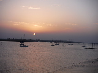
Sunset, Burnham-on-Crouch
SWC Walk 162 North Fambridge to Burnham-on-Crouch
Oct-17 • thomasgrabow on Flickr
swcwalks swcwalk162 banner 37019436704
![Big Winter Skies SWC Walk 162 North Fambridge to Burnham-on-Crouch [taken by Ana H.]](https://live.staticflickr.com/65535/51832837290_a88ca2e391_n.jpg)
Big Winter Skies
SWC Walk 162 North Fambridge to Burnham-on-Crouch [taken by Ana H.]
Jan-22 • thomasgrabow on Flickr
swcwalks swcwalk162 banner 51832837290

On the sea wall
North Fambridge to Burnham-on-Crouch walk
Mar-15 • Saturdaywalker on Flickr
walkicon swcwalks swcwalk162 16360902723

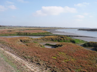
Mudflats
SWC Walk 162 North Fambridge to Burnham-on-Crouch Taken by Pia R
Mar-15 • thomasgrabow on Flickr
swcwalks swcwalk162 walkicon 19088599455

Seawall on River Crouch, North Fambridge
SWC Walk 162 North Fambridge to Burnham-on-Crouch
Oct-17 • thomasgrabow on Flickr
swcwalks swcwalk162 walkicon 37729090751
Bridgemarsh Creek
SWC Walk 162 North Fambridge to Burnham-on-Crouch
Oct-17 • thomasgrabow on Flickr
swcwalks swcwalk162 walkicon 37058993723
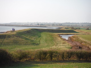
Upriver View from The Cliff
SWC Walk 162 North Fambridge to Burnham-on-Crouch
Oct-17 • thomasgrabow on Flickr
swcwalks swcwalk162 walkicon 37019539274
| Length |
20.9 km (13.0 mi), with 126/120m ascent/descent. For a shorter or longer walk see below Walk Options |
|---|---|
| Toughness | 2 out of 10, with 4 hours 30 minutes walking time. For the whole outing, including trains, sights and meals, allow at least 7 ½ hours. |
| Walk Notes |
Serenity, tranquillity, solitude and ‘Big Skies’: you’ll find lots of it on this walk on the Dengie Peninsula in Essex, which largely follows the tidal River Crouch eastwards towards the North Sea, on a wide grassy path atop the sea wall, and with the prevailing wind in the back. Far away from any conurbations, you’ll experience wide open and scenic countryside, stark but beautiful, with constantly changing river views, salt marshes, reed ponds, mudflats, creeks, rich bird life, sailing boats and marinas, to then end along the promenade in charming Burnham-on-Crouch, with its plethora of tea options.
|
| Walk Options |
Shortcuts:
An Extension near the end, further along the Crouch towards the Sea, then turning back inland through the saltmarshes and along farm tracks, adds 6.0 km (3.7 mi). |
| Maps | OS Explorer: 176 (Blackwater Estuary)
OS Landranger: 168 (Colchester) |
| Travel |
North Fambridge Station, map reference TQ 855 977, is 5 km east of South Woodham Ferrers and 7m above sea level. Burnham- on-Crouch Station, map reference TQ 984 965, is 9 km east of North Fambridge and 14m above sea level. Both are in Essex. North Fambridge and Burnham-on-Crouch are on the single track Crouch Valley Line from Wickford to Southminster, with one train every 40 minutes Mon-Sat, and hourly trains Sun. Trains to Wickford depart from Liverpool Street (journey time to Fambridge 55 mins Mon-Sat, 66 mins Sun). Saturday Walkers’ Club: Take the train closest to 9.30 hours. |
| Lunch |
The Three Horseshoes Lower Burnham Road, Althorne, Essex, CM3 6DP (01621 740 307). Located 11.5 km into the walk, the Three Horseshoes provides good value, freshly prepared food, from a wide-ranging menu. It has two bars and a large garden at the side. |
| Tea | Plenty of options for tea in Burnham. See the pdf for details. |
| Profile | |
|---|---|
| Help Us! |
After the walk, please leave a comment, it really helps. Thanks! You can also upload photos to the SWC Group on Flickr (upload your photos) and videos to Youtube. This walk's tags are: |
| By Train |
Out (not a train station) Back (not a train station) |
| By Car |
Start CM3 6NE Map Directions Return to the start: Finish CM0 8BQ Map Directions Travel to the start: |
| Amazon | |
| Help |
National Rail: 03457 48 49 50 • Traveline (bus times): 0871 200 22 33 (12p/min) • TFL (London) : 0343 222 1234 |
| Version |
Apr-24 Thomas G |
| Copyright | © Saturday Walkers Club. All Rights Reserved. No commercial use. No copying. No derivatives. Free with attribution for one time non-commercial use only. www.walkingclub.org.uk/site/license.shtml |


Walk Directions
Full directions for this walk are in a PDF file (link above) which you can print, or download on to a Kindle, tablet, or smartphone.
This is just the introduction. This walk's detailed directions are in a PDF available from wwww.walkingclub.org.uk