Oxshott to Cobham via Painshill walk
Surrey heaths, the Mole valley and the opportunity to visit “England's most elegant 18thC landscape garden”.
| Length |
Main Walk: 12¼ km† (7.6 miles). Two hours 40 minutes walking time. For the whole excursion including trains, sights and meals, allow at least 7 hours. Alternative Walk, via Downside: 13¼ km (8.25 miles). Two hours 55 minutes walking time. Longer Walk, via Painshill & Downside: 15¼ km† (9.5 miles). Three hours 20 minutes walking time. Circular Walk, starting from Cobham: 15½ km†‡ (9.6 miles). Three hours 30 minutes walking time. Alternative Circular Walk, via Downside: 16½ km‡ (10.25 miles). Three hours 45 minutes walking time. Long Circular Walk, via Painshill & Downside: 18½ km†‡ (11.5 miles). Four hours 10 minutes walking time.
† Add 5 km (3 miles) if visiting Painshill Park and doing the full suggested route through the landscape garden. See Features below.
|
|---|---|
| OS Maps |
Explorers 146 & 161, with a tiny part of the Alternative and Longer Walks on 145. Oxshott, map reference TQ141609, is in Surrey, 6 km W of Epsom. |
| Toughness |
2 out of 10 (3 for the Circular walks). |
| Features |
The main purpose of this fairly short walk is the opportunity to visit the Grade Ⅰ listed Painshill Park, which has been open to the public since 1997. “England's most elegant 18thC landscape garden” was created by Charles Hamilton between 1738 and 1773, inspired by Renaissance art and his visits to Italy on the Grand Tour. The garden was at the forefront of the ‘picturesque’ movement, combining naturalistic landscaping enriched by follies, water features, a vineyard, shrubberies and exotic trees from North America. By the mid-20thC, however, all the follies were dilapidated and the garden had become an impenetrable jungle. Fortunately it was acquired by Elmbridge Borough Council in 1980 and since then the Painshill Park Trust has succeeded both in restoring it and replanting the grounds with species introduced by Hamilton. ‘On the Door’ admission to Painshill Park is £13.50 (2024), but there is an informative display in its Kitchen Garden which prospective visitors can browse before deciding whether to enter. A suggested route through the grounds is outlined in the directions, based on the ‘Historic Route’ taken by visitors in the 1740s. Shorter routes can easily be devised from the site map offered to visitors. Most of the follies can be visited at all times, but the Grotto and Gothic Tower might only be open at weekends. In this affluent area of Surrey the rest of the walk is not the most rural, but the circuit from Oxshott is long enough to provide interest in its own right. The station is on the edge of Oxshott Heath and the walk starts across a succession of partly-wooded commons. It crosses the A3 to loop around the picturesque Black Pond on Esher Common, then recrosses it to go past Middle Pond on Fairmile Common. The remainder of the route into the centre of Cobham is a fairly lengthy stretch along its quiet residential streets, a consequence of the town being hemmed in by the River Mole, the railway and the A3. Just before the suggested lunch pub the route passes Cobham Mill, an 18thC water mill which has been restored to full working order by a Preservation Trust (open to the public from 2-5pm on the 2nd Sunday in Apr–Oct). The afternoon leg starts with a short out-and-back loop to Painshill Park. On the assumption that you will have spent time visiting the garden, the remainder of the Main Walk simply goes back through the town and along residential streets to Stoke D'Abernon, the part of Cobham containing its station. |
| Walk Options |
If you do not intend to visit Painshill Park you can do a completely different afternoon route via Downside. This Alternative Walk goes across water meadows and along country lanes to the south of the town as it skirts around the extensive Cobham Park Estate (sadly with no public access). You could also switch to this afternoon route after visiting Painshill Park, making a Longer Walk. Both of these options would be problematic after heavy rain since the water meadows outside Cobham are prone to flooding. You can extend all of these walk options by doing a Circular Walk from Cobham station. This goes via Littleheath and takes a different route across Oxshott Heath before joining the main route at Sandy Lane. With this longer start you could choose to cut out the mid-morning loop around the northern part of Esher Common. Some minor short cuts and alternative routes are also mentioned in the directions. |
| Additional Notes |
This walk was refashioned in 2022-23. The original version was a circular walk from Oxshott covering much the same ground but in the opposite direction, going out via Stoke D'Abernon and Downside. This allowed for a shorter start (as well as finish) from Cobham station, but the paucity of tea options near both stations was always a major drawback. With the opening of a new coffee house near Cobham station in 2022 it made sense to finish the walk there, in the process transferring the attractive stretch through Esher Common to the morning and the optional loop via Downside to the afternoon. |
| Transport |
Oxshott and Cobham are adjacent stations on the “New Guildford Line”, with a half-hourly service from Waterloo (hourly on Sundays) taking around 40 minutes. Cobham is further from London, so buy a return to Cobham & Stoke D'Abernon (its full name). The town of Cobham is served by several bus routes, with Stagecoach 715 providing a regular service to Kingston and Guildford (hourly Mon–Sat, every 90 minutes Sun). However, on this short walk you are never too far from one of the stations. If driving, it is easier to park in Stoke D'Abernon and do the Circular Walk (or take the train to Oxshott). Both station car parks cost around £8 before noon Mon–Fri, £4 otherwise (2024), but street parking is possible near Cobham station except before 9.30am on weekdays. |
| Suggested Train |
Take the train nearest to 10:20 from Waterloo to Oxshott (or Cobham & Stoke D'Abernon for the Circular Walk). |
| Train Times |
|
| Timetables |
|
| River Levels |
|
| Lunch |
The suggested place in Cobham (after 7¾ km from Oxshott, or 11 km on the full walk from Cobham) is The Bear (01932-967040) on River Hill, the bend of the A245 between Mill Road and the High Street. This Young's pub has a secluded back garden as well as a patio area at the front, and serves an interesting selection of pub food including a lighter ‘brunch menu’ on weekdays. There are also several coffee shops on the High Street (Costa, Caffè Nero, GAIL's, etc) but no other pubs nearby. Most of this affluent town's eateries are in fact distinctly up-market (eg. The Ivy Cobham Garden, “a haven of relaxed sophisticated dining”) and you would need to call ahead to be sure of a table at one of its restaurants. Cobham's other pubs are passed on the two routes out of the town, although visitors to Painshill Park could have a light lunch in the tearoom inside its grounds (see below). The later pub option on the Main Walk is The Running Mare (01932-862007) on Tilt Common. On the Alternative & Longer Walks a short detour on the town's outskirts would take you to The Plough (01932-589790). The final pub on these options is The Cricketers (01932-862105), which has a patio area under a Magnolia grandiflora on the edge of Downside Common. |
| Tea |
If you spend time visiting Painshill Park and want some mid-afternoon refreshment before continuing the walk, Mr Hamilton's Tea Room is open daily to 5.30pm summer, 3.30pm winter. The suggested tea place at the end of all the walk options is Cafè Barbera (01932-863926; open daily to 8pm Mon–Sat, 4pm Sun), an Italian coffee house in the parade of shops next to Cobham station. Stronger fare is available at The Old Plough (01932-862244), an attractive pub with a large beer garden which is a five-minute walk away at the other end of Station Road. |
| Profile | |
|---|---|
| Help Us! |
After the walk, please leave a comment, it really helps. Thanks! You can also upload photos to the SWC Group on Flickr (upload your photos) and videos to Youtube. This walk's tags are: |
| By Train |
Out (not a train station) Back (not a train station) |
| By Car |
Start KT22 0TA Map Directions Return to the start: Finish KT11 3BW Map Directions Travel to the start: |
| Amazon | |
| Help |
National Rail: 03457 48 49 50 • Traveline (bus times): 0871 200 22 33 (12p/min) • TFL (London) : 0343 222 1234 |
| Version |
May-24 Sean |
| Copyright | © Saturday Walkers Club. All Rights Reserved. No commercial use. No copying. No derivatives. Free with attribution for one time non-commercial use only. www.walkingclub.org.uk/site/license.shtml |


Walk Directions
Click the heading below to show/hide the walk route for the selected option(s).


 Walk Map
©
Walk Options ( Main | Circ. )
Click on any option to show only the sections making up that route, or the heading above to show all sections.
- Main Walk (12¼ km)
Walk Directions
Click on any section heading to switch between detailed directions and an outline, or the heading above to switch all sections.
If you are doing a Circular Walk (from Cobham), start at §B.
- Oxshott Station to West Bridge (1¾ km)
- From the station forecourt take a short path through the trees onto Oxshott Heath. Make your way up to the War Memorial on the escarpment ahead and take a path heading north-west through woodland to Sandy Lane. Cross the road and take the bridleway heading due north. In 250m fork left onto the horse ride signposted to West Bridge.
- Arriving from London, cross the footbridge and leave from the other platform. Bear right across the station forecourt and take the path to the right of some small buildings, going up through a belt of trees to an information panel about Oxshott Heath? at a crosspaths.
- For a fairly gentle route up the escarpment ahead turn right at the crosspaths, then in 25m fork left onto a sandy path heading N. This soon starts to climb gently and in 150m goes up a few steps to a T-junction with a broad path. Turn left and follow this uphill past wooden barriers to come to a prominent War Memorial? in 100m.
- Shortly after passing the memorial fork right in front of a gnarled oak tree onto a clear woodland path leading away from the escarpment. In 75m turn half-right at a five-way path junction to head NW and carry on in this direction for 400m, following occasional “Trail 2000” waymarker posts with white arrows pointing ahead at path crossings.
- The path eventually drops down towards a road (Sandy Lane). Just before reaching it turn right at a path crossing, gradually approaching the road and passing Roundhill Way opposite. In 25m cross Sandy Lane carefully (it has more traffic than you might expect) and take the signposted public bridleway opposite, heading N.
- In 200m the bridleway enters Esher Common, although there is only an inconspicuous Elmbridge Council notice at this point. In a further 50m you come to a major path junction and fork left onto a horse ride signposted to West Bridge, heading NW.
- After about 100m the trees thin out and you emerge into open heathland. Carry on along this broad ride for a further 500m, turning left halfway along at a junction with an all-weather path. The ride eventually goes back into woodland and comes to a T-junction with another horse ride, with West Bridge (over the all-too-audible Cobham Bypass) up the slope to your right.
- Cobham Station to Littleheath Lane (2¼ km)
- Follow Station Road out to the A245, turn left and go along it for 250m. Turn right onto the footpath opposite Tilt Road and follow it along the edge of Knowle Hill Park into Littleheath Common. Veer left off the footpath and turn left in front of Littleheath Common Pond. Go past the end of the houses on Heathfield, then veer right onto a woodland path leading to Somerville Road. Turn left to reach its T-junction with Littleheath Lane.
- Arriving from London, cross the footbridge and leave from the other platform. Bear right across the station forecourt and go all the way along Station Road, passing The Old Plough at the T-junction with the A245 (Stoke Road). Turn left and go along the main road for 250m, crossing over at the pedestrian lights halfway along.
- Immediately after crossing Aspen Close turn right onto a signposted footpath, going past wooden barriers. At the end of this long fenced path between gardens go through a wooden gate and continue for 400m alongside a chainlink fence protecting the private Knowle Hill Park.
- After going through another wooden gate a footpath waymarker implies that the right of way veers left into the adjacent field to go along its top edge, but it is easier to stay on the main path. The two paths rejoin after 100m, after which you continue over (or around) a stile onto a path through a wooded area, now with a chainlink fence on the right.
- In 150m veer left off the public footpath by a “Danger · Deep water” sign. Follow the side path down a small slope and through the wooded Littleheath Common?, crossing a ditch on a plank bridge along the way.
- In 100m fork left at a little triangle of paths to come out in front of Littleheath Common Pond. Turn left onto the path around this picturesque pond, passing a “Woodland life” information panel. As you approach the first of the lakeside properties by the corner of the pond, the path forks.
-
Main route
- Fork left onto the path through the wood, crossing a few ditches on plank bridges along the way and then passing a small pond on the right. You will eventually be leaving the wood away to the right, but the path curves slightly to the left as it meanders through the trees.
-
About 125m after passing the pond fork right onto a short link path, then turn right at a path T-junction onto the main path through the middle of the wood.
- If you miss this useful link path turn sharp right (almost doubling back) where the two main paths merge 50m further on.
-
Follow the main path as it heads roughly ENE through the wood, crossing a ditch on a plank bridge along the way.
This path runs parallel with Littleheath Lane off to the left and you might be able to glimpse (or hear) its traffic from time to time.
- In about 200m the path bends left and comes out onto a side street (Somerville Road) near its junction with Littleheath Lane. Turn left and go out to this T-junction.
-
Alternative route
- Fork right, passing a “Lake inhabitants” information panel and continuing alongside the property's garden fence. After passing the house turn right onto the end of a cul-de-sac (Heathfield).
- Go all the way along Heathfield, passing the rest of the lakeside houses. At the end turn left onto Somerville Road and follow this out to its T-junction with Littleheath Lane.
- Littleheath Lane to West Bridge (2¾ km)
- Turn right and go along Littleheath Lane to Brown's Corner. Turn left to go up the western edge of Oxshott Heath for 250m. Turn right to go along a wooded escarpment, eventually reaching the War Memorial. Go round to the left to join a horse ride heading west-northwest …
- Turn right onto Littleheath Lane and follow this tree-lined street for 350m to a sharp right-hand bend at Brown's Corner. Leave the road and go through the small parking area ahead into the wooded Oxshott Heath?.
- Turn left onto the bridleway signposted to Sandy Lane (or the path alongside it; the two merge in several places). After climbing gently along the western edge of the woodland for 250m turn right at a clearing with a large tree trunk on the left. Pass to the left of a “No Riding” notice on a tree and go up a slope, with a large pit down to your left.
- After scrambling over some tree roots you pass a waymarker post with a white arrow near the top of the slope. Go through a semi-open area with a cluster of benches and continue along the edge of a wooded escarpment, with glimpses of the heathland down to your right. In 200m keep ahead at a crosspaths.
- In 125m you reach a small clearing where you veer right onto a path which leads out into a more open area. Follow the path round to the left to stay on the edge of the escarpment, with several benches where you could pause to admire the view. In 150m you come to a prominent War Memorial?.
- Turn left onto the path to the right of the memorial, heading directly away from the escarpment. Almost immediately fork left at an oblique path crossing. Follow the path round to the right to go along a broad open strip of grassland, with woodland on both sides.
- In 100m fork left at a Y-junction, then shortly afterwards turn left at a path crossing onto a signposted Horse Ride into the trees, heading WNW. Follow this path gently downhill through the wooded Oxshott Heath for 350m, halfway along bearing slightly left at a major path junction.
- The path eventually drops down towards a road (Sandy Lane). Go past horse barriers, …
- …
- …
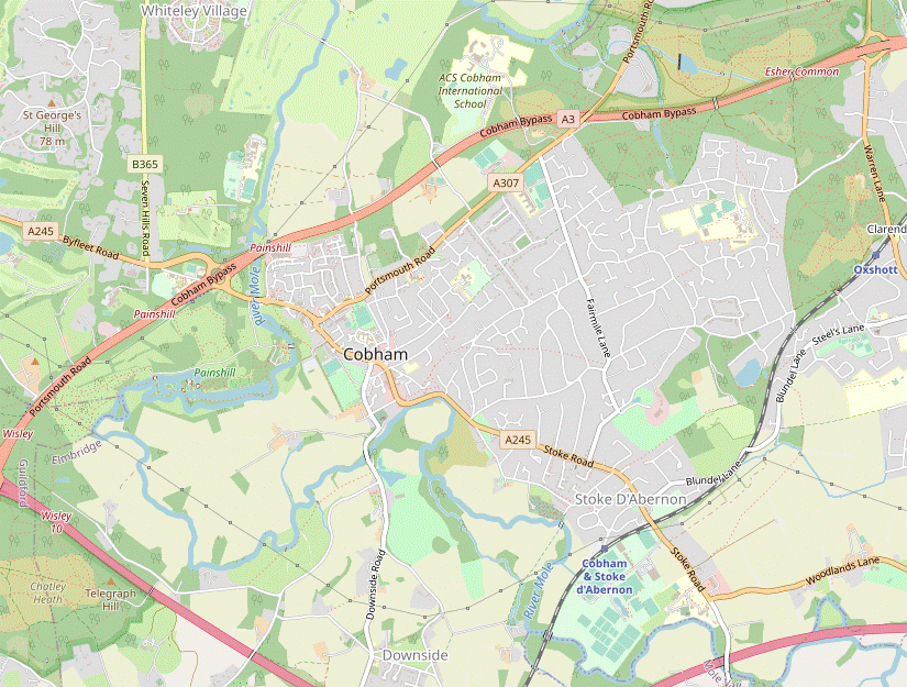
- An Esher Common loop around Black Pond (2½ km)
-
 For the full walk, cross over the A3 on West Bridge and turn left. Loop around Black Pond and take any convenient route heading east across Esher Common. Turn right onto a horse ride and follow it back across the A3 on East Bridge. In 150m turn right onto an all-surface path heading west, rejoining the horse ride leading to West Bridge.
-
Turn right at the T-junction and go up the slope, finally getting a clear view of the traffic as you cross the busy A3 dual carriageway on West Bridge.
After the loop around Esher Common you will be recrossing the A3 on East Bridge, about 500m away to the right.
-
On the other side of the bridge turn left, going down a slope. Near the bottom the suggested route is to bear right off the main track onto a clear path through the trees. This merges with another path from the right and runs parallel to the track until that swings off to the left.
- If you choose to stay on the main track, bear right onto the footpath signposted to Black Pond where the track swings left.
-
The various paths all merge and lead you through wooden horse barriers onto a causeway along the western edge of Black Pond?, a picturesque spot. At the far end of the causeway go between another set of barriers, then turn right onto a side path onto the heathland.
- If you miss this useful short cut you can simply turn right at a major path junction a little further on; the two paths merge at the top of a small slope.
- Continue in the same direction on a long straight path through a pine wood. After passing more barriers bear right onto a signposted horse ride to come to an information panel “Exploring Esher Commons” by a four-way signpost confusingly named “Five Ways”. The suggested route is not to take any of the signposted rides but to bear left in a direction midway between the horse rides to Longy Down and Esher Common.
-
You soon pick up a clear sandy path heading E through the heathland – the Fifth Way? – with woodland sloping up to your left. The simplest route is to follow this path for about 400m to a major junction with a broad sandy horse ride.
- About halfway along you could veer left onto a narrow path leading up to the trees and take in the view from one of the wooden benches there, then continue on a path along the woodland edge.
- Either way, turn right when you reach the broad horse ride to head S, which leads directly to East Bridge. Cross back over the A3 and follow the ride down past a small fenced-off pond on the left. In a further 100m turn right off the horse ride onto a little triangle of paths behind a wooden barrier, leading to an all-weather path at a sharp bend.
-
Bear right onto this path, heading W through a wooded area. In 250m the path swings left and meets the horse ride from Sandy Lane at a bend. Turn right onto the ride and repeat your earlier route up to the T-junction near West Bridge.
- West Bridge to Fairmile Lane (1½ km)
- Take a short path ahead through the trees and turn left onto the other bridleway coming down from West Bridge. In 100m take either of two paths on the right, which rejoin in 250m. Continue past Middle Pond and follow a woodland path heading south-west through Fairmile Common to a parking area at the top of Green Lane. Go down this street and cross Fairmile Lane onto the bridleway opposite, Hogshill Lane.
-
Turn right at the T-junction and then immediately turn left onto a short path through the trees. At the end turn left onto a bridleway, heading away from West Bridge. In 100m, where there is a gate into a private garden ahead on your left, turn right onto the left-hand of two paths into the trees, a permissive bridleway.
- In fact you could take either path as they rejoin in 250m, but the right-hand path is rather uneven where it goes over tree roots along an ancient boundary (and is also closer to the traffic noise).
- The bridleway curves gently round to the right and eventually rejoins the other path near the main road. Immediately after this path junction ignore a waymarked bridleway off to the left and follow the main path as it swings left and right to come to the north-eastern corner of Middle Pond?.
- Keep ahead along the short northern edge of the lake. In the corner follow the path round to the left, climbing through the trees alongside a black metal fence protecting the grounds of Lakewood House. At the corner of the property turn right, now alongside a chainlink fence.
- At the end of the boundary fence keep ahead through a small clearing, dotted with pine trees; you are now on the wooded Fairmile Common. On the other side of the clearing there are two paths more or less straight ahead and you need to take the left-hand path, initially heading SW.
- You will be following this woodland path for the next 400m, gradually curving round to the left and crossing two horse rides along the way. On the far side of the wood it goes up a short slope and comes to a small parking area, with an information panel about the group of Esher Commons?.
- Veer right through the car park and go all the way down a broad residential street (Green Lane). At the bottom cross Fairmile Lane onto the signposted bridleway opposite.
- Fairmile Lane to Cobham (River Hill) (2 km)
-
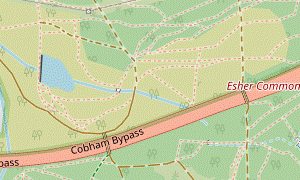
 Head west along a mix of enclosed paths and residential streets into Cobham. 300m before the end of Hogshill Lane, turn left into French Gardens and cut through alleyways to come out onto the A245 opposite Cobham Mill. Turn right to reach The Bear on River Hill.
- In 150m the bridleway leads into a residential street (Burstead Close). In a further 250m, shortly before its T-junction with Icklingham Road, bear left as indicated onto a path along the edge of a small triangular area. Go straight across the wide street lined with grand houses onto another enclosed path.
- The path goes between houses and then alongside the grounds of a primary school. At the far end keep ahead on another residential street (Hogshill Lane). After passing Tartar Road the road narrows and goes downhill but you can use a raised walkway on its right-hand side, rejoining the road at the bottom of the slope.
-
Shortly after rejoining Hogshill Lane turn left into French Gardens. In 100m turn left off this cul-de-sac onto the signposted footpath between houses #4 & #6. Go along this tarmac path to a T-junction and turn right into another alleyway.
- At the end turn left onto Cedar Road. Do not follow it round to the left into Cedar Avenue but keep ahead past a footpath signpost onto a short tarmac path. This comes out onto the A245 (Mill Road) directly opposite Cobham Mill?, with the River Mole just beyond it. Cross the main road carefully and turn right onto the roadside path.
- In 150m Mill Road curves up to the right by a small crescent-shaped patch of grass with an information panel “The Riverhill Project” (a possible picnic spot). For the suggested lunch pub go back across the road to The Bear; this is the only pub in the vicinity but there are more eateries further along the A245, in the next section.
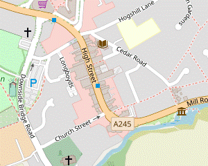
- River Hill to Painshill Park (1¼ km)
-
 Go along the High Street for 250m, then turn left into Hollyhedge Road. Cross Downside Bridge Road and keep ahead across a playing field. Bear right onto Church Path. Where this meets the A245 turn left onto a footpath alongside Painshill Park's access road. Skirt around the car park and take the site's access path across the River Mole to the entrance, where you can detour into the Kitchen Garden to read about its history.
- If visiting the landscape garden, pay the entrance fee at the ticket kiosk and use the site map to plan a route through it.
- Follow the main road round to the right, where it becomes Cobham's High Street. In the next 250m you pass several coffee shops including Costa, Caffè Nero and GAIL's. Unless you want to investigate more refreshment places beyond the prominent Clock Tower, turn left into Hollyhedge Road.
- In a short pedestrianised section you pass a mosaic and information panel on the left about the Diggers?. Continue along the road to its T-junction with Downside Bridge Road, passing a large car park on the left.
- Cross the main road carefully onto a large playing field and head for its far right-hand corner, 200m away. On the far side bear right onto a tarmac path (Church Path), passing a football ground and gradually approaching a main road (Between Streets).
-
Just before the signposted access road to Painshill Park turn left onto a tree-lined walkway, parallel to this driveway. At the far end the path swings round to the left in front of the entrance to the site's new car park.
After visiting Painshill Park the walk returns to this path, so if you have changed your mind you can skip the rest of this section and resume the directions at [?] in §H.
- The shortest route to the site would be to go straight across the car park but pedestrians are expected to use the all-weather path around its left-hand edge. On the far side the path goes down to the right and then swings left to cross the River Mole on an elegant new footbridge.
- On the far side it is worth detouring into the walled Kitchen Garden on the left, which has information panels about the site's history. The path then zig-zags left and right up to the ticket kiosk, where you would need to pay the entrance fee to proceed any further.
-
Notes on visiting Painshill Park (up to 5 km)
- Visitors are offered a Map of Painshill describing its main features and showing several suggested circular routes. If it is still in print, more detailed information is available in an inexpensive guide book, Painshill reborn.
- The waymarked Historic Route (about 4½ km) takes you through the whole garden and passes all its main features. Two shorter and less hilly routes (each about 2½ km) cover just the eastern half of the garden.
-
If you have time the Suggested Route (about 5 km) is to follow most of the Historic Route, but on the way back cross Five Arch Bridge and return along the south side of the lake for fine views across the water of the Ruined Abbey, Vineyard, etc.
- Painshill Park to St Andrew's Church (1 km)
- Take the long tree-lined footpath (Anvil Lane) heading south-southeast away from the car park entrance. Turn left at a footpath T-junction to come out onto Downside Bridge Road. Turn right and go along the road for 100m, then take a path through the churchyard to St Andrew's church.
- After exiting the site retrace your steps across the river bridge and follow the pedestrian path all the way around the right-hand side of the car park. Go past a wooden barrier and across a track, then turn right at a footpath signpost onto the continuation of the path from the main road.
- Follow this long straight tree-lined footpath for 450m, at first with allotments and a football ground on your left, then a large playing field. At the end turn left at a footpath T-junction to go past Cobham Community Garden? and more allotments to Downside Bridge Road.
- Cross the road carefully and turn right to go along its pavement for 100m. At the junction with Church Street go through a gap in the wall into the churchyard. Take the path towards the church tower and go around it to the main door of St Andrew's church?, which is worth a visit.
- St Andrew's Church to Cobham Station (2¼ km)
- Take the path around the eastern end of the church and along the side of the churchyard. Turn right onto Church Road to return to the A245 at River Hill. Follow the main road alongside the River Mole to Tilt Common. Bear right onto Tilt Road and follow it for 1 km to Stoke D'Abernon. After the road turns sharply left, turn right onto a footpath. At a roundabout keep ahead on Bray Road and turn right at the end to reach Cobham station.
- Turn left out of the church door and take the path around its eastern end. The path leads out past the attractive Church Stile House? to Church Street. Turn right and go along it to the High Street, with another chance to visit The Bear opposite.
- Turn right onto the A245 and follow it round the left-hand bend at River Hill, briefly retracing your outward route alongside the River Mole. Keep ahead past the historic mill and weir on a fenced tarmac path, curving round to the right between the main road and the river.
- In 400m, where the A245 turns half-left at the start of a common, bear right into Tilt Road. You soon pass The Running Mare pub / restaurant on the right, a possible late refreshment stop.
- You now simply follow the walkway alongside Tilt Road for 800m. Towards the end it is separated from the road by a broad grassy strip, with a cemetery away to the right. Shortly before the road turns sharply left stay on the tarmac path as it turns half-left and keep ahead to cross the road.
-
Follow the path into an alleyway beside Stile Cottage, signposted as a footpath. At the far end keep ahead past a roundabout onto Bray Road. Where this meets Station Road there is a parade of shops on the right containing Zara's Deli & Kitchen and the suggested tea place, Cafè Barbera.
- For stronger fare you would have to detour 400m off to the left to find The Old Plough at the other end of Station Road.
- The station is just off to the right, with a couple of takeaway places on its forecourt. Trains to London leave from Platform 1, on the near side.
- River Hill to St Andrew's Church direct (¼ • ¾ km)
-
At the start of the High Street turn left into Church Street,
…
- To investigate more eateries you could go along the High Street for 250m, turn left into Hollyhedge Road and then take a footpath alongside a car park to reach the church via Downside Bridge Road.
-
Main route (¼ km)
- Follow the main road briefly round to the right and turn left into Church Street, the side road opposite an alleyway behind The Bear. In 125m you pass the attractive Church Stile House? and turn left through a lychgate …
-
Alternative route (¾ km)
- …
- … In 100m turn left into Old Rectory Gardens, passing a large car park on your right. In 50m, where the road bends left, bear right onto a footpath to stay alongside the car park.
- At the end turn left onto Downside Bridge Road and … …
- St Andrew's Church to Downside Common (2¾ km)
- From the High Street go along Church Street and into the churchyard. Go past the church and out along a lane to Downside Bridge Road. Follow the road away from the town centre, crossing the River Mole on Downside Bridge. Turn right onto a footpath going across water meadows for 1¼ km. Turn left onto Pointers Road and continue along Ockham Lane and Chilbrook Road to Downside Common.
- Leave the churchyard by its main gate, opposite the church door. Turn right onto a lane and follow it out to Downside Bridge Road. Keep ahead on the walkway on its left-hand side, later curving left and crossing the River Mole on Downside Bridge. Unless you want to visit an alternative pub, turn right after 125m onto a signposted footpath into a meadow.
-
Detour to The Plough (+300m)
- Carry on briefly along Downside Road, then turn right into Plough Lane to find The Plough. Return the same way and turn left onto the footpath into the meadow.
- Follow the clear grassy path directly away from the road. In 250m go through a gap and continue alongside a line of trees in a second meadow. In 200m you cross a ditch on a plank bridge and the path bears left to cross a third meadow.
-
In 250m go through a metal gate and follow the grassy path alongside a hedge, curving round to the right and with occasional glimpses of the river beyond it. In 200m you cross a stream on a wooden footbridge and emerge into another large meadow. Turn half-left as indicated to go diagonally across it, aiming for a kissing gate in the centre of a low fence across the meadow.
After passing under power lines you might be able to glimpse the top of Painshill Park's Gothic Tower along the line of the pylons, poking out above the trees nearly 2 km away.
-
Go through the gate and continue in much the same direction towards a metal fieldgate on the far side of the meadow. Go over a slightly awkward stile beside it onto a lane (Pointers Road).
You now have around 1 km of road walking, but there is not usually much traffic to contend with on these country lanes.
- Turn left and follow Pointers Road for 200m to a T-junction. Turn right onto Ockham Lane, then in 125m turn left into Chilbrook Road. Go all the way along this lane, which bends right at Chilbrook Farm halfway along.
- The lane eventually comes to a junction with the busier Horsley Road. Cross this road carefully onto a corner of Downside Common and go along its left-hand edge for 125m to come to a possible refreshment stop, The Cricketers.
- Downside Common to Cobham Station (2½ km)
- Bear right across the common and take the bridleway to the left of St Michael's Chapel, heading north-east. Follow this around the edge of the Cobham Park Estate, eventually going back across the river. Keep ahead briefly on Tilt Road, then …
- After passing the pub turn half-right across the grass, aiming for a copse 100m away. Follow a path through these trees (or skirt around them) and continue across the common in the same direction, aiming to meet the road ahead (Downside Common Road) at its junction with a short link road across the common.
- Bear left to cross Downside Common Road and take the signposted bridleway to the left of St Michael's Chapel?, passing a Victorian water pump?. The bridleway continues as a broad tree-lined path between farm fields for 250m.
- At the end go through a wooden gate and turn right onto a long straight driveway (the continuation of the right of way), with views through the belt of trees on the left into the Cobham Park Estate?.
- In 350m, where the drive swings round to the right, bear left through a wooden side gate onto a broad track, still on the right of way around the private estate. In 300m the track crosses a stream and continues between hedges for a further 500m before crossing the River Mole again on a substantial footbridge.
- Follow the path up a slope to join a short driveway by the entrance to a cemetery, which leads out to Tilt Road at a bend. Keep ahead on the grassy strip on its right-hand side for 60m, then bear right onto a tarmac path coming in from the other side of the road (the Main Walk route).
- …
- …
- Oxshott Heath is managed by a group of honorary Conservators, an arrangement established by an Act of Parliament in 1904.
- The prominent War Memorial on Oxshott Heath was erected after World War Ⅰ by Sir Robert MacAlpine (‘concrete Bob’), founder of the MacAlpine construction company.
- Littleheath Common (or Little Heath) is managed for nature conservation, amenity and access. The pond – large enough to be called a lake – was originally a gravel pit.
- Black Pond is the largest of the ponds on Esher Commons. It was created to supply water to Claremont Landscape Garden (NT), 1 km to the north.
- The woodland around Middle Pond was added to Esher Commons in 1974, as compensation when this Site of Special Scientific Interest was cut in two by the A3.
- Esher Commons is the collective name given to a group of predominantly wooded commons south-west of the town: Arbrook, Esher, Fairmile and West End. They are managed by Elmbridge Borough Council and sometimes also known as Elmbridge Commons.
- Cobham Mill was built in the late 18thC and was in use until 1928. Other buildings on the site were demolished in 1953 to relieve traffic congestion on Mill Road but this small mill survived and has been restored to full working order.
- The Diggers were a group of Protestant radicals who attempted to farm on common land in the disorderly period following the execution of Charles Ⅰ in 1649. They issued pamphlets and established communal settlements on St George's Hill and then Little Heath, but in each case were driven off by local landowners.
- The Cobham Community Garden is part of a local initiative “to create a greener and more sustainable Cobham”.
- St Andrew, Cobham dates from the 12thC but was much altered and extended in the 19thC. It contains a unique brass depicting the nativity.
- Church Stile House is a rare example in Surrey of ‘double jettying’, with each floor overhanging the one below. It was substantially rebuilt in 1624 around an earlier 15thC house and is listed Grade Ⅱ*.
- St Michael's Chapel (in the parish of Ockham) still has regular Church of England services, even though it is not much bigger than a garden shed.
- The water pump was erected in 1858 by Harvey Combe, owner of Cobham Park, for the benefit of the cottagers on Downside Common.
- The Cobham Park Estate has been owned by the Combe family since 1806, with the present mansion (not visible) being completed in 1873. The family sold the house in the late 20thC and it has been converted into luxury retirement apartments.
Continue the directions at §D.
The main route through the wood ahead can be muddy, so in wet weather it would be advisable to take the alternative route in [?].
If you are not doing the loop around Black Pond on the other side of the main road, go to §E.
You will be following a mix of residential streets and bridleways (shown on street maps as extensions of Hogshill Lane) into the centre of Cobham.
If you are doing the Alternative Walk (via Downside instead of Painshill), go to §J.
If you are doing the Longer Walk (via Downside), go to §K.
If you want to investigate more eateries along the High Street, take the alternative route in [?].
You will be following a waymarked footpath through water meadows bordering the River Mole for the next 1¼ km. In the past there have been official notices stating that the landowner has had problems with people “treating the land as a public park”, so take care to stay on the right of way.
Walk Notes
» Last updated: May 10, 2024
Return to Top | Walk Map | Walk Options | Walk Directions.