Pandy Inn to Llanvihangel Crucorney walk
Offa's Dyke Path along Hatterrall Hill and Ridge, return through the Vale of Ewyas past Llanthony Priory and the Leaning Church in Cwmyoy

Llanthony Priory Ruins
SWC Walk 335 - Pandy Inn to Llanvihangel Crucorney (via Llanthony and Cwmyoy)
May-18 • thomasgrabow on Flickr
swcwalks swcwalk335 banner 47678681141

Llanthony Priory Ruins
SWC Walk 335 - Pandy Inn to Llanvihangel Crucorney (via Llanthony and Cwmyoy)
May-18 • thomasgrabow on Flickr
swcwalks swcwalk335 banner 47625723012

St. Martin’s, Cwmyoy, the ‘Leaning Church’
SWC Walk 335 - Pandy Inn to Llanvihangel Crucorney (via Llanthony and Cwmyoy)
May-18 • thomasgrabow on Flickr
swcwalks swcwalk335 banner 47625724782

View up the Vale of Ewyas, from Hatterrall Hill
SWC Walk 335 - Pandy Inn to Llanvihangel Crucorney (via Llanthony and Cwmyoy)
May-18 • thomasgrabow on Flickr
swcwalks swcwalk335 walkicon 47625751342

Llanthony Priory Ruins
SWC Walk 335 - Pandy Inn to Llanvihangel Crucorney (via Llanthony and Cwmyoy)
May-18 • thomasgrabow on Flickr
swcwalks swcwalk335 walkicon 47678675481

Sugar Loaf in early April 19, from Bwlch Trewyn
Apr-19 • thomasgrabow on Flickr
swcwalks swcwalk335 walkicon 46762498445
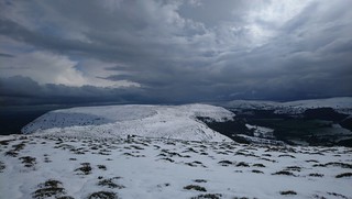
Hatterrall Hill (Walk Recce early April 19)
SWC Walk 335 - Pandy Inn to Llanvihangel Crucorney (via Llanthony and Cwmyoy)
Apr-19 • thomasgrabow on Flickr
swcwalks swcwalk335 walkicon 46762492865
| Length |
24.7 km (15.4 mi), with 871/836m ascent/descent. For a shorter or longer walk see below Walk Options. |
|---|---|
| Toughness |
8 out of 10, with 6 ½ hours walking time. |
| Walk Notes |
This route at the south easterly end of the Black Mountains area in the Brecon Beacons National Park starts with a steep ascent onto an Iron Age hillfort site and on to Hatterrall Hill, and then follows Offa’s Dyke Path and the Beacons Way across Hatterrall Hill and the largely heathery – but in parts boggy – open moorland of the dramatic Hatterrall Ridge with fine panoramic views from this natural boundary of a ridge up along the wild, lonely and beautiful Vale of Ewyas (the valley of the River Honddu and the easternmost valley of The Black Mountains) and across the South Wales mountain ranges to the west, and over the plains of the Welsh/English borderlands to the east, on a good day all the way to The Cotswolds and the Malvern Hills.
Shorter and longer options are described. |
| Walk Options |
A Shortcut just before lunch cuts 3.2 km/2.0 mi and 121m ascent.
|
| Travel |
Pandy Inn Bus Stop, map reference SO 335 224, is 9 km north east of Abergavenny, 200 km west northwest of Charing Cross and 109m above sea level; Skirrid Inn Bus Stop, map reference SO 325 206, is 2 km south west of Pandy and 144m above sea level. Both are in Monmouthshire, Wales. Pandy Inn and Llanvihangel Crucorney are served by Bus Line 23 (Newport – Abergavenny – Hereford) with 7 buses a day, Mon-Sat only. Saturday Walkers’ Club: This walk is doable as a daywalk from London, especially if you have motorised transport, but also if taking a train to Abergavenny to connect to above bus service. |
| Maps |
OS Explorer: OL13 (Brecon Beacons National Park – Eastern Area)
|
| Lunch |
Llanthony Priory Hotel Cellar Bar Llanthony, Abergavenny, Monmouthshire, NP7 7NN (01873 890 487). The Priory Hotel’s bar is located 12.5 km/7.8 mi into the walk.
|
| Tea |
The Old Pandy Inn Hereford Road Pandy, Monmouthshire, NP7 8DR (01873 890 208). At the start of the walk, so a tea stop if walked in reverse.
|
| Brecon Beacons |
The Brecon Beacons National Park is in south Wales. It consists of bare, grassy, glacial mountains, with north facing escarpments. Its peaks, just shy of 1,000m (3,000ft), are the highest mountains in the southern UK. The national park is also noted for reservoirs, and the Dan yr Ogof caves. Its 4 mountain areas, from west to east are:
|
|---|---|
| Welsh Glossary |
aber: estuary, confluence, river mouth; afon: river; affwys: abyss; allt: hillside, cliff; aran: high place; ban/fan/bannau (pl): peak/beacon/crest, hill/mountain; big: peak; blaen: source of river, head of valley; bod: dwelling; bre: hill; bron: hill-breast; bryn: hill; bwlch: gap/col/pass; cadair: chair; cae: field; caer/gaer: stronghold, fort; capel: chapel; carn/garn/carnedd/garnedd: cairn, heap of stones, tumulus; carreg/garreg: stone, rock; castell: castle; cefn: ridge, hillside; celli: grove/copse; cerwyn: pot-hole; cist: chest; clog/clogwyn: cliff; clun: meadow; clwyd: hurdle/gate; clydach: torrent; coch/goch: red; coed: wood; craig/graig: rock; crib/cribyn: crest, ridge, summit; crug: mound; cul: narrow; cwm: hanging valley/corrie/bowl/dale; cyfrwy: ridge between two summits (saddle); ddinas: fort; dibyn: steep slope, precipice; dim: no; din: hill-fortress; disgwylfa: place of observation, look-out point; dôl: meadow; du/ddu: black, dark; dwfr/dŵr: water; dyffryn: valley; -dyn: fortified enclosure; eglwys: church; eira: snow; eisteddfod: meeting-place, assembly; esgair: ridge; fach/bach: small; fawr/mawr: large; fechan: smaller; ffald: sheep-fold, pound, pen, run; ffordd: way, road; ffridd: pasture; ffrwd: stream, torrent; ffynnon: spring/well; gallt: wooded hill; ganol: middle; garth: promontory, hill, enclosure; glan/lan: river-bank, hillock; glas: green (when referring to grass, pasture or leaves), blue (when relating to the sea or air); glyn: deep valley, glen; gors: bog; gorsedd: tumulus, barrow, hillock; gwyddfa: mound, tumulus; gwylfa: look-out point; gwyn/gwen: white; gwynt: wind; hafn: gorge, ravine; hafod: summer dwelling; hen: old; hendre(f): winter dwelling, old home, permanent abode; heol: road; hesgyn: bog; hir: long; is: below, lower; isaf: lower/lowest; llan: church, monastery; llawr: level area, floor of valley; llech: slab, stone, rock; llther: slope; lluest: shieling, cottage, hut; llwch: lake, dust; llwybr: path; llwyd: grey, brown; llwyn: bush, grove; llyn: lake; llynwyn: pool/puddle, moat; maen: stone; maes: open field, plain; mawn: peat; mawnog: peat-bog; melyn: yellow; merthyr: burial place, church; moel/foel: bare, bald/bare hill; mynydd: mountain, moorland; nant: brook/stream, dingle/glen; neuadd: hall; newydd: new; ogof/gogof: cave; pant: hollow; parc: park, field, enclosure; pen: head, top/end, edge; penrhyn: promontory; pentre(f): homestead, village; perfedd: middle; perth: bush, brake, hedge; plas: hall, mansion; pont/bont: bridge; porth: gate/gateway, harbour/bay/landing-place/ferry; pwll: pit, pool; rhiw: hill, slope; rhos: moor, promontory; rhudd: red, crimson; rhyd: ford; sarn: causeway; sgwd/rhaeadr: waterfall; sticill: stile; sych: dry; tafarn: tavern; tâl: end, top; talar: headland (of field); tan/dan: below; tarren/darren: escarpment; tir: land, territory; tor: break, gap; tre/tref: settlement, hamlet, town; twlch: tump, knoll; twll: hole, pit; tŵr: tower; twyn: hill; tŷ: house; uchaf: upper, highest; uwch: above, over; waun/gwaun: moorland, meadow; wen/wyn: white; y, yr, ‘r: the; ynys: island, holm, river-meadow; ysgol: ladder, formation on mountain-side/school; ysgwydd: shoulder (of mountain); ystafell: chamber, hiding-place; ystrad: wide valley, holm, river-meadow. |
| Profile | |
| Help Us! |
After the walk, please leave a comment, it really helps. Thanks! You can also upload photos to the SWC Group on Flickr (upload your photos) and videos to Youtube. This walk's tags are: |
| By Car |
Start Old Pandy Inn, Hereford Rd, Pandy, Abergavenny, NP7 8DR Map Directions Finish Llanvihangel Crucorney Abergavenny NP7 8DH Map Directions |
| Amazon | |
| Help |
National Rail: 03457 48 49 50 • Traveline (bus times): 0871 200 22 33 (12p/min) • TFL (London) : 0343 222 1234 |
| Version |
Apr-24 Thomas G |
| Copyright | © Saturday Walkers Club. All Rights Reserved. No commercial use. No copying. No derivatives. Free with attribution for one time non-commercial use only. www.walkingclub.org.uk/site/license.shtml |


Walk Directions
Full directions for this walk are in a PDF file (link above) which you can print, or download on to a Kindle, tablet, or smartphone.
This is just the introduction. This walk's detailed directions are in a PDF available from wwww.walkingclub.org.uk