Pewsey Circular via Avebury walk
Long walk over Wiltshire downs to Avebury World Heritage Site
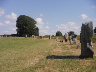
Avebury Standing Stones, SW quartile
SWC Walk 255 Pewsey Circular via Avebury
Aug-15 • thomasgrabow on Flickr
walkicon swcwalks swcwalk255 banner 21194868176
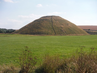
Silbury Hill Close-Up
SWC Walk 255 Pewsey Circular via Avebury
Aug-15 • thomasgrabow on Flickr
walkicon swcwalks swcwalk255 21032901440

West Kennett Long Barrow, inside the Chamber
SWC Walk 255 Pewsey Circular via Avebury
Aug-15 • thomasgrabow on Flickr
walkicon swcwalks swcwalk255 20598029164

Fyfield Down Sarsen Field
SWC Walk 255 Pewsey Circular via Avebury
Sep-15 • thomasgrabow on Flickr
walkicon swcwalks swcwalk255 21191839204
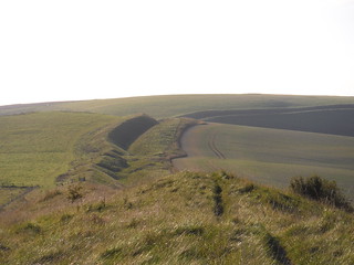
Wandsdyke in the evening sun
SWC Walk 255 Pewsey Circular via Avebury
Sep-15 • thomasgrabow on Flickr
walkicon swcwalks swcwalk255 21626657458
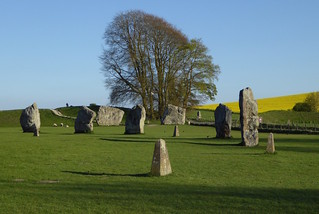
Avebury stone circle
Pewsey to Avebury walk
Apr-17 • Saturdaywalker on Flickr
walkicon swcwalks swcwalk255 34204857816
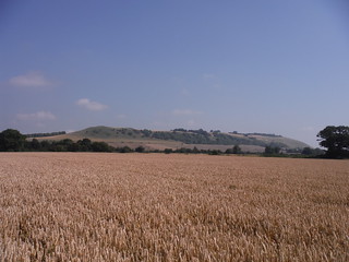
Oare Hill from nearby field
SWC Walk 255 Pewsey Circular via Avebury
Aug-15 • thomasgrabow on Flickr
swcwalks swcwalk255 21031577200
| Length | 36.5 km (22.7 mi), with 616m ascent/descent.
For an Alternative Ending in Avebury, a shorter or a longer walk, see below Walk Options. |
|---|---|
| Toughness | 9 out of 10, with 8 ½ hours walking time. For the whole outing, including trains, sights and meals, allow at least 12 ½ hours. |
| Walk Notes |
This is a strenuous excursion into the heart of Neolithic Wiltshire, a mysterious landscape full of pre-historic earthworks, standing stones, sarsen fields and hillforts as well as barrows – burial mounds of kings and warriors. The route passes through or past four of the most important prehistoric sites in Britain: Fyfield Down Sarsen Stones Field, Avebury Standing Stones and Bank & Ditch Earthworks, Silbury Hill and West Kennett Long Barrow (two other sites, The Sanctuary and Windmill Hill, can be explored on extensions).
There are four different options to finish the walk in Avebury, with a rating of between 4/10 and 8/10.
|
| Maps | OS Explorer: 157 (Marlborough & Savernake Forest)
OS Landranger: 173 (Swindon & Devizes) |
| Travel |
Pewsey Station, map reference SU 161 603, is 25 km south of Swindon, 116 km west of London, and 116m above sea level. Marlborough, map reference SU 187 691, is 9 km north east of Pewsey and 132m above sea level. Both are in Wiltshire. It is on the Berkshire and Hampshire line, served by Intercity trains between London and the West Country. The journey time is about 60 minutes. Pewsey is outside the Network South East Area, necessitating split journey tickets at either Reading or Newbury if using the Network Railcard. Saturday Walkers’ Club: Take the train closest to 08.00 hours for the full walk; the train closest to 10.00 hours is an option for the Avebury Endings. |
| Walk Options |
Buses 42 and 49 serve Avebury, enabling a finish there on a shorter walk:
The resultant walk options are as follows:
|
| B&Bs in or near Avebury |
Avebury Lodge High Street, Avebury (01672 539 023)
|
| Lunch |
The Who’d A Thought It Lockeridge, Marlborough, Wiltshire, SN8 4EL (01672 861 255). The Who’d A Thought It is located 9.7 km (6.0 mi) into the walk. A traditional English village pub.
|
| Tea |
For tea options in Pewsey please consult page 2 of the pdf. |
| Profile | |
|---|---|
| Help Us! |
After the walk, please leave a comment, it really helps. Thanks! You can also upload photos to the SWC Group on Flickr (upload your photos) and videos to Youtube. This walk's tags are: |
| By Train |
Out (not a train station) Back (not a train station) |
| By Car |
Start SN9 5ER Map Directions |
| Amazon | |
| Help |
National Rail: 03457 48 49 50 • Traveline (bus times): 0871 200 22 33 (12p/min) • TFL (London) : 0343 222 1234 |
| Version |
Jun-22 Thomas G |
| Copyright | © Saturday Walkers Club. All Rights Reserved. No commercial use. No copying. No derivatives. Free with attribution for one time non-commercial use only. www.walkingclub.org.uk/site/license.shtml |

Walk Directions
Full directions for this walk are in a PDF file (link above) which you can print, or download on to a Kindle, tablet, or smartphone.
This is just the introduction. This walk's detailed directions are in a PDF available from wwww.walkingclub.org.uk