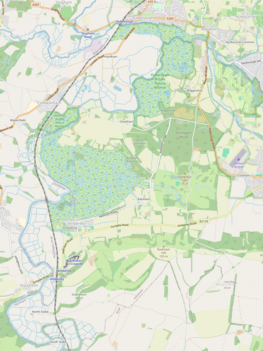
Pulborough Circular walk
Long but easy walk which explores the water meadows of the River Arun, with the South Downs as a dramatic backdrop.
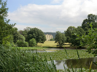
CIMG8396
Parham House across the lake
Aug-13 • Sean O'Neill
banner, swcwalk14, swcwalks 5910626254267003666 P

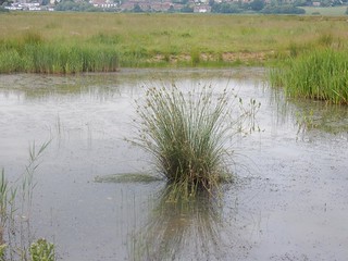
CIMG8389
Amberley Wild Brooks in summer
Aug-13 • Sean O'Neill
swcwalk14, swcwalks, walkicon 5910626129958002018 P
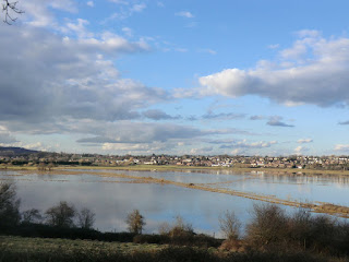
CIMG9984
Winter view from the Hanger viewpoint, Pulborough Brooks
Mar-14 • Sean O'Neill
swcwalk14, swcwalks, walkicon 5986331483182871522 P
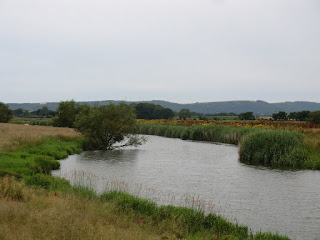
CIMG8990
River Arun at Pulborough Brooks
Jul-15 • Sean O'Neill
swcwalk14, swcwalks, walkicon 6172970639441979762 P
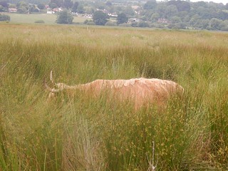
Cow, Pulborough Brooks,
Pulborough Brooks, Pulborough Circular
swcwalks swcwalk14 walkicon pulboroughbrooks 42658603982
| Length |
Main Walk: 21 km† (13.0 miles). Four hours 50 minutes walking time. For the whole excursion including trains, sights and meals, allow at least 10 hours. Shorter Walk, starting from Amberley: 16 km† (9.9 miles). Three hours 40 minutes walking time. Alternative Short Walk, finishing at Amberley: 12¼ km (7.6 miles). Two hours 40 minutes walking time. Extended Alternative Walk, via South Stoke: 18¼ km (11.3 miles). Four hours 10 minutes walking time. † Subtract 3½ km (2.2 miles; 50 minutes) if omitting Parham Park. See Walk Options below. |
|---|---|
| OS Map |
Explorer OL10 (previously 121). Pulborough, map reference TQ043186, is in West Sussex, 18 km SW of Horsham. |
| Toughness |
4 out of 10 (3 for the Short and Extended Alternative Walks, 1 for the Alt. Short Walk). |
| Features |
This walk climbs gently at first to give a panoramic view of the South Downs from the low hills above Pulborough, where it joins the Wey-South Path. This goes past two medieval bridges on the canalised River Arun, part of an important transport link between London and the South Coast in the early 19thC, then crosses the extensive water meadows of Amberley Wildbrooks to the picturesque village of Amberley. The walk continues through the landscaped grounds of Parham Park, with its large herd of dark-coated fallow deer and views of Parham House. The many “Private – No Access” notices do not encourage walkers to detour off the right of way to visit this fine Elizabethan manor house, but for the record it is open Wed–Fri, Sun & BH from Easter to mid-October; admission is £15.50, or £11.50 for the gardens only (2024). In the next section you might see gliders taking off and landing at close quarters as you go along the edge of Parham Airfield. You then have the opportunity to spend some time bird-watching in the RSPB Pulborough Brooks Nature Reserve at Wiggonholt, which has a tearoom in its Visitor Centre. The final stretch is across the water meadows and alongside the River Arun back to Pulborough. Note that the water meadows around the River Arun are deliberately flooded in winter and the Wey-South Path through Amberley Wildbrooks can be boggy at almost any time of the year. |
| Walk Options |
In the afternoon you can save 3½ km by heading directly to Pulborough Brooks along a quiet country lane, although this short cut omits the interesting features of Parham Park and Parham Airfield. The ending of the Arundel to Amberley walk (1–32) is from Amberley village to its station, and the directions for this link route have been included here (in both directions) to allow for Shorter Walks starting or finishing at that station. In addition, a route via South Stoke has been taken from other Amberley & Arundel walks to provide an Extended Alternative Walk, looping back to Amberley station. If you bring the relevant directions you could combine parts of this walk with other SWC walks. On the main route you could switch at Cootham to either the Billingshurst to Amberley walk (#8) or the Amberley Circular walk (#11), which take different routes up the South Downs escarpment on their way to Amberley station. On the Extended Alternative Walk you could continue along the river valley to Arundel, using the directions in the Arundel Circular walk (#100). |
| Transport |
Pulborough and Amberley are on the Arun Valley line, with a half-hourly service from Victoria (hourly on Sundays) taking around 1 hour 15 minutes to Pulborough. A return to Amberley is the same price as Pulborough and valid for all the walk options (although you would also need a single from Arundel back to Amberley if you extended the walk there). If you want to take a bus to Pulborough station, Compass 100 runs hourly along the A283 via Cootham and the entrance to the Pulborough Brooks Nature Reserve, up to around 5.40pm (Mon–Sat). If driving, the station car park at Pulborough costs around £7.50 Mon–Sat, £3 Sun & BH (2024). |
| Suggested Train |
Take the train nearest to 09:30 from Victoria to Pulborough (or Amberley for the Short Walk). |
| Train Times |
|
| Timetables |
|
| River Levels |
|
| Lunch |
There are two attractive pubs in Amberley (8½–9 km from Pulborough) but at the time of writing neither is ideal for a pub lunch. In the village the Black Horse (01798-831183; food to 2pm Mon–Sat, 6pm Sun) has a fairly expensive restaurant with table service where booking ahead is advisable. An alternative on the Main Walk would normally be to carry on for another ten minutes to The Sportsman (01798-831787), but check in advance: in 2024 it was being run by volunteers and its food offerings were limited. The village tea room (see below) is open from 10.30am (except Wed) but does not serve lunches. However, sandwiches and other snacks can be bought at the nearby Village Stores, which is open daily. All these places are passed on the Shorter Walk but the Crown Inn (01903-742625; food to 3pm Wed–Sat, 3.45pm Sun; closed Mon & Tue) in Cootham is more suitably placed on this option, after about 9 km. If you were doing one of the shorter variations with a late start from Pulborough you could make an early stop at the White Hart (01798-874903), next to Stopham Bridge. |
| Tea |
The café at the RSPB Visitor Centre (01798-875851; open to 4pm) at Pulborough Brooks is conveniently situated for a mid-afternoon break and (like The Sportsman) its terrace has fine views over the water meadows. There are a couple of refreshment places at the point where the walk route enters Pulborough, about 1¼ km from the station. The Pulbrew (01798-903060; open to 5pm Sat & Mon–Wed, 4pm Sun, Thu & Fri) is a new independent coffee shop at #46 Lower Street; stronger fare is available at the Oddfellows Arms (01798-874888), a short detour off to the right. Ten minutes before the station the suggested route passes the Chequers Hotel on the A29, but this has been in administration for many years and might well have closed. Alternatively, staying on the main road would take you past Macklin's Bar (07930-988666; closed Mon) at #3 Lower Street, a new cocktail and wine bar. There are only some fast food shops near the station itself. If you made an early lunch stop at the White Hart (see above) – or are doing one of the shorter options as an afternoon walk – you could break for tea at the Amberley Village Tea Room (01798-839196; open to 4pm but closed Wed). At the end of the Alternative Walks you have a choice of the terrace gardens at Riverside South Downs (01798-831066; Apr–Sep open to 5pm daily; Oct–Mar to 4pm Wed–Sun, closed Mon & Tue) or an attractive country pub with a beer garden, the Bridge Inn (01798-831619; closes at 5pm Sun & BH; closed all day Mon, Tue and the Wed after a BH Mon). These are on opposite sides of Houghton Bridge and very close to Amberley station. |
| Profile | |
|---|---|
| Help Us! |
After the walk, please leave a comment, it really helps. Thanks! You can also upload photos to the SWC Group on Flickr (upload your photos) and videos to Youtube. This walk's tags are: |
| By Train |
Out (not a train station) Back (not a train station) |
| By Car |
Start RH20 1AH Map Directions |
| Amazon | |
| Help |
National Rail: 03457 48 49 50 • Traveline (bus times): 0871 200 22 33 (12p/min) • TFL (London) : 0343 222 1234 |
| Version |
Jul-24 Sean |
| Copyright | © Saturday Walkers Club. All Rights Reserved. No commercial use. No copying. No derivatives. Free with attribution for one time non-commercial use only. www.walkingclub.org.uk/site/license.shtml |


Walk Directions
Click the heading below to show/hide the walk route for the selected option(s).


 Walk Map
©
Walk Options ( Main | Shorter | Alt. )
Click on any option to show only the sections making up that route, or the heading above to show all sections.
- Main Walk (21 km)
Walk Directions
Click on any section heading to switch between detailed directions and an outline, or the heading above to switch all sections.
If you are doing the Shorter Walk (from Amberley station), start at §G.
- Pulborough Station to Stopham Bridge (2¼ km)
- Turn left out of the station and take a footpath on the other side of a chainlink fence up to a road. Turn left to cross the railway and follow the road round to the left, then keep ahead on a footpath across a field. At Park Farm join the Wey-South Path on a bridleway going up to and then along the edge of a wood, eventually dropping down to cross the A283 by Stopham Bridge.
- After leaving the station building, do not go down to the main road but instead turn left. Head briefly towards the main car park but almost immediately veer right by a small bicycle shelter to get onto a public footpath on the other side of a chainlink fence, with the car park on your left and a service road to an industrial estate on your right.
- In 350m this footpath comes out onto a minor road where you turn left, crossing over the railway. Follow the lane for 300m, curving round to the left to head W, then veer left up a small bank and go through a gate onto a signposted footpath. This climbs gently through a field, soon with fine views of the South Downs and Pulborough Brooks away to your left.
- In 350m the path passes a WW Ⅱ pillbox and zig-zags left and right through some trees. Go straight across the driveway to Park Farm onto a bridleway; you are now on the Wey-South Path? (WSP), which you will be following all the way to Amberley. Follow the fenced grassy path gently uphill towards a wood.
- At the top turn left at a bridleway signpost just inside the wood, with Park Mound? up on your right. Follow this attractive sandy path gently downhill near the woodland edge for 1 km, eventually dropping down more steeply to meet the A283. Cross the main road carefully and continue on a lane past the White Hart pub, with a fine view of the medieval Stopham Bridge? over the River Arun on your right.
- Stopham Bridge to Greatham Bridge (2¾ km)
- Go past the White Hart pub on a lane which curves round to the left. Just before it joins the A283, bear right onto a footpath which goes across fields and footbridges to a pumping station. Follow the path as it turns past buildings, crosses the railway and comes to the A29. Cross over and take a footpath just off to the right which leads into and through a long narrow strip of woodland. At the far end turn left onto a minor road to reach Greatham Bridge.
- Follow the lane as it climbs gently uphill and curves left to go parallel to the A283. Where it swings left to join the main road opposite a garden centre, go through a metal kissing gate onto a signposted footpath. Do not take the obvious path straight ahead (used by anglers) but immediately fork left onto an easily-missed narrow path through the undergrowth, heading SE.
- The path leads to a substantial footbridge where you cross the River Arun. On the other side bear left to head SE again across a potentially muddy field, leaving it via a kissing gate on the far side. Go up some steps and cross the River Rother on a bridge.
- The signposted right of way now zig-zags through Hardham Water Works and Hardham Mill Business Park. Follow the tarmac lane for 200m, then (with a level crossing visible ahead) turn right onto a concrete track towards some industrial units and holiday lets. turn left in front of the buildings onto a path with a hedge on your right. Go through a metal fieldgate and turn right onto the trackbed of an old branch line (which ran to to Midhurst and Petersfield).
- In 175m turn left off the track, going through a metal fieldgate and across a small field towards a bridge. Go over the main railway line and down to the A29. Cross this busy road with great care and turn right briefly along the pavement, then in 25m go over a stile on the left. Keep right across a small field and go through a wooden kissing gate on the far side.
- Go down a slope and continue on a slightly awkward path through a long narrow strip of woodland for 1 km, the course of an abandoned stretch of canal. The path eventually comes out onto a lane where you turn left. Follow the lane up to and across the other medieval bridge across the River Arun on this walk, Greatham Bridge?.
- Greatham Bridge to Amberley (village) (3½ km)
- On the other side of the bridge, cross a stile on the right to go onto a riverside path. This soon leaves the riverbank and climbs to reach a farm track. Follow the footpath signs around farm buildings and eventually down into Amberley Wild Brooks. Head south through these water meadows for 2 km, initially on a grassy path and later farm tracks. Turn left when you reach Amberley village.
- From the bridge you can see your onward route on the right, a path heading S along the low riverside embankment. Go over a stile next to a metal fieldgate onto this path. After crossing a stile the path goes up to a farm track, where you turn right. In 150m keep right where it merges with another track. In a further 200m follow the track round to the left by the entrance to Quell Farm House.
- In 150m the track swerves right and left past the last of some farm buildings, then comes to the corner of a small wood. Turn right as indicated onto a path going gently downhill beside the wood, then past Hayles Barn. At the bottom of the slope turn left along a broad grassy track. Finally, go through a metal fieldgate into Amberley Wildbrooks? and turn right as indicated.
- You will be heading S through these water meadows for the next 2 km. Initially the path is quite faint and overgrown, with plank bridges and boardwalks over some boggy stretches. Later it widens into a broad grassy path between ditches. After joining a potentially waterlogged chalky farm track it swings right, then curves back to the left to head S again.
-
Eventually you go through a side gate and up a slope into the picturesque village of Amberley, with its many thatched cottages. At the top turn left into Hog Lane. In 125m the Black Horse pub / restaurant is at the junction with East Street (ahead) and the High Street on the right.
This is one of the possible lunch places; the village's other pub is 800m away on the continuation of the Main Walk, along East Street.
- Amberley to the South Downs Bridge • Amberley Station (2¾ • 3¾ km)
-
Go through the centre of the village on Church Street and continue on a footpath over the railway line and across the water meadows to the River Arun. Turn left and follow the riverside path for 1 km to the footbridge carrying the South Downs Way (SDW) across the river.
- To complete the Alternative Short Walk, cross the river and turn left to continue along the right-hand bank. Turn left onto the B2139 and recross the river on Houghton Bridge, …
- For either of the Alternative Walks go down the High Street, passing the Village Stores. With the Amberley Village Tea Room ahead on your left, turn right into Church Street, leaving the WSP and heading W through the village. At the far end you pass the entrance to St Michael's church?, which is worth a visit.
- To continue the walk follow the lane down a short slope. This leads to a footpath going below the imposing rear wall of Amberley Castle? and onwards to the railway line. Cross the tracks carefully and follow a tree-lined grassy path for 250m to reach the water meadows.
- Bear left as indicated and follow a clear grassy path heading SW and then W for 450m (detouring around any boggy areas as necessary). Eventually you climb onto a low embankment and turn left along it, with the River Arun just off to your right. Continue along the raised path for just over 1 km to the substantial footbridge carrying the South Downs Way? (SDW).
-
Finishing at Amberley Station (+1 km)
- For the suggested route cross the river and turn left to continue in the same direction on the right-hand bank. You can see one of the tea places on the opposite bank shortly before reaching the road bridge, where you turn left onto the B2139.
- …
- …
- The South Downs Bridge to South Stoke Farm (4 km)
- Cross the river and turn right to follow the SDW as far as Houghton Lane. Turn left and go along the lane to Houghton village. Cross the B2139 and go down South Lane, joining the Monarch's Way (MW). Continue on a bridleway alongside the River Arun, leaving the MW at the entrance to Arundel Park and continuing for a further 1½ km to South Stoke Farm.
- For the Extended Alternative Walk cross the river and turn right to go back along the other side, leaving the Walk 1–32 route and briefly joining the SDW. In 150m, where the river turns right, veer left off the embankment at a three-way footpath signpost.
- Go through a wooden gate onto a slightly raised grassy path alongside a ditch. In 200m zig-zag right and left as indicated and go through another gate. Follow the path gently uphill alongside a wire fence. At the end turn left onto Houghton Lane, leaving the SDW.
- After passing some farm outbuildings in a dip the lane climbs past an attractive thatched cottage and comes to a T-junction with the B2139 in the small village of Houghton. Cross the B2139 carefully (slightly to the right) and go down South Lane, passing more attractive old cottages and joining the Monarch's Way? (MW).
- At the bottom of the lane continue on a track curving gently round to the right. Go through a side gate onto a signposted bridleway along the right-hand side of a small open area. Keep right where a footpath joins from the left to continue along the bridleway, with the River Arun just off to the left.
- The path goes below a wooded cliff for 750m, with some potentially boggy stretches if the river has overflowed. After gradually curving round to the left it continues for a further 500m along a narrow strip between the river and a solid flint wall, the boundary of the Arundel Park estate.
-
The path eventually turns away from the river and comes to a high metal kissing gate in the wall. Ignore the gate into Arundel Park and continue along the bridleway, leaving the MW.
The walk now follows another part of the Walk 1–32 route, to the farm bridge at South Stoke.
- Follow the undulating woodland path for 600m, never far from the river on your left. The path later widens into a track and after a short climb you go through a side gate to the left of a wooden fieldgate into a large farm field. Follow the track down its left-hand edge and round to the right in the bottom corner, then turn left through a wooden fieldgate.
- In 300m bear right across a concrete yard as indicated, going through a metal fieldgate onto a raised grassy track between fences. The imposing South Stoke Barn? is ahead on your right and you pass a large agricultural barn down to your left. At the end of the track bear right and go out along the farm's driveway, passing the Gothic-style barn (now a wedding venue) on your right.
- South Stoke Farm to Amberley Station (3 km)
- Go through the hamlet of South Stoke and cross the river on the farm bridge. Turn left onto a footpath heading west, briefly alongside the river and then along an old meander. Go over the Gurkha Bridge and follow the path across a field to North Stoke. Head north on Stoke Road towards Houghton Bridge, with the suggested route being a footpath on the left to reach it via another meander and the riverside embankment. Turn right onto the B2139, passing the Riverside Café and the Bridge Inn by the junction with Stoke Road. Go under the railway bridge and turn right up the station's approach road.
- At the end of the farm drive turn left onto a lane and follow it round to the left, passing some cottages on the right. At the next bend the entrance to St Leonard's church? (which is worth a quick visit) is half-hidden in the trees on your right. Beyond the church the lane becomes an unsurfaced farm track leading down to South Stoke Bridge.
- Cross the River Arun on the farm bridge. On the other side turn left through a wooden kissing gate to head W on the riverside path, leaving the Walk 1–32 route. In 150m the path veers away from the river and you go through another kissing gate into a narrow strip of woodland, an old meander of the river.
- In 400m the path turns left to cross a patch of boggy ground on the Gurkha Bridge?. Go through another gate into a field and follow a grassy path heading N up the low hill ahead. At the top go through a kissing gate and keep ahead along a short enclosed path to a lane.
- Turn left to come to a road junction by an old red telephone box (the ‘North Stoke Information Point’). If you are not making the detour below to see an unusual old church, turn right at this junction onto the lane heading N.
-
Detour to North Stoke Church (+500m)
- Keep ahead on the lane through the hamlet, signposted to St Mary's Church. The church of St Mary the Virgin? is at the far end, to the left of North Stoke Farmhouse.
- Return the same way and turn left at the junction by the telephone box.
-
Follow the lane (Stoke Road) downhill and round to the right. In 300m, just after an isolated house on the right, there is a signposted footpath into a narrow strip of woodland on the left.
- For a direct route you could simply go all the way along Stoke Road to the tea places at Houghton Bridge. If you take this short cut (saving 300m), complete the directions at [?].
- For the suggested route, turn left onto this footpath, a tree-lined path along the course of another old meander. In 500m it comes out onto the riverbank, where you turn right. Go through a couple of gates and continue along the embankment for 500m, with water meadows on your right. At the end the path crosses a side channel on a footbridge. Go up to the road bridge and turn right onto the B2139.
- Take great care as you go across Houghton Bridge? on this busy road, using the refuges to dodge the traffic. Two tea places here are the terrace garden of Riverside South Downs, ahead on your left; and the Bridge Inn on the right-hand side of the road, entered via its car park in Stoke Road.
- To complete the walk, return to the B2139 and head E, away from the river. Go under the railway bridge and turn right up the approach road for the Amberley Museum and Heritage Centre?, with the station on the right. Cross the footbridge to Platform 1 for trains to London.
- Amberley Station to Amberley (village) (3½ km)
- Go down to the B2139 and turn left under the railway bridge. Turn right onto a footpath which leads to an embankment alongside the River Arun. Follow the riverside path for 1½ km, then turn right and head east across the water meadows. Cross the railway and go through Amberley village to East Street.
- Leave the station at the London end of the platform. Go down its approach road and turn left onto the B2139. After passing under the railway bridge turn right onto a signposted footpath, a gravel track which leads to a grassy path past a cluster of park homes.
- At the end climb onto a low embankment to continue alongside the River Arun, initially heading NW. You now follow this riverside path for 1½ km, keeping the river on your left and passing the substantial footbridge carrying the South Downs Way.
- Opposite Bury church on the other side of the river, turn right at a footpath signpost. Follow a clear grassy path heading E and then NE across the water meadows for 450m (detouring around any boggy areas as necessary). Continue along a tree-lined grassy path leading to the railway line.
- Cross the tracks carefully and keep left, avoiding a farm track up to the right. In 200m the path goes below the imposing rear wall of Amberley Castle? and leads to a lane going up a short slope past St Michael's church?, which is worth a visit.
- Go all the way through the picturesque village of Amberley on Church Street, with its many thatched cottages. At the far end, with the Amberley Village Tea Room ahead on your right, turn left uphill. You soon pass the Village Stores and then the Black Horse pub / restaurant on your right. At the top turn right into East Street.
- Amberley to West Lodges (2¾ km)
- Leave the village on East Street, in 800m passing The Sportsman pub. After the last house turn left onto a footpath which goes down through fields and past the derelict Rackham Mill to reach a wood. Turn right and go along its southern edge to Rackham Street. Turn left and go along the lane to the entrance to Parham Park.
- Head E out of the village along East Street, leaving the WSP but joining the West Sussex Literary Trail? (WSLT). In 800m you come to The Sportsman pub on your left, another possible refreshment stop. In a further 500m, after the last of the houses and just before a ‘national speed limit’ sign, turn half-left onto a public footpath sloping diagonally down across a large field, heading NE.
- At the field boundary go through a hedge and across a ditch on a plank bridge. Keep ahead across a smaller field and go over a stile in the corner onto a path through a copse. This comes out in front of the derelict Rackham Mill, with a house up on the right. After veering left between these buildings the path heads N towards a wood, with views across the water meadows on your left.
- In 250m the path crosses a brook on a footbridge. On the other side turn right at a three-armed footpath sign to go along a path just inside the wood. In 150m you pass an isolated house on the right and come to a waymarked footpath junction.
-
Main route
- Carry on along the main path, which comes out into a small open area with sandstone rocks off to the left and Rackham Old School? on the right. Turn left onto the lane ahead (Rackham Street), gently uphill. Keep right at a road junction, signposted to Wiggonholt.
-
Woodland route
- Turn left at the footpath junction to go up through the wood. The path curves right and climbs gently for 250m, heading roughly NE. On the far side of the wood turn right onto a lane and then immediately fork left at a road junction (onto Rackham Street), signposted to Wiggonholt.
- From the junction go along Rackham Street for 125m to reach a pair of lodges on the right, with notices about Parham Park.
- Through Parham Park (2 km)
- Go through the gate on the right to enter the park and follow the driveway past a lake to a T-junction. Keep ahead on a grassy path, which later merges with the main driveway to Parham House. Follow this out past Douglas's Lodge to the A283.
- Turn right through a side gate into Parham Park and go along its driveway. In 500m there is a lake on the right (with a distant view of Parham House? beyond it), then a high stone garden wall.
- The drive comes to a T-junction, with private roads off to both sides. Keep ahead (slightly to the right) on a grassy path, the continuation of the right of way. In 250m the footpath curves left to merge with the main driveway to the house, which is now behind you on your right.
- Leave Parham Park at Douglas's Lodge and continue on the tree-lined drive, passing a ‘Heritage Trail 2000’ information panel about the house and its owners. On its way out to the A283 you pass a plaque for the Queen's Green Canopy?.
- Parham Park to Hurston Lane (2 km)
- Head east along the A283. Either carry on to Cootham to visit the Crown Inn and then take a footpath skirting around the eastern side of Parham Airfield, or take the first footpath on the left to go along its western edge. After the two paths meet continue along a fenced path which curves round to the left, then veers right through a small wood to Hurston Lane.
-
Route via Cootham
- Head E along the A283 for 400m to reach the Crown Inn on the outskirts of Cootham.
- After visiting the pub, retrace your steps along the A283 but almost immediately turn right into Dukes Row, signposted as a footpath. Go up to a row of cottages and turn left, parallel to the main road and heading W. At the end of the houses follow the lane round to the right into Cootham Park.
- Follow the driveway through this small estate of park homes. At the far end veer left to continue on a potentially muddy footpath through a belt of woodland. The path crosses a brook on a plank footbridge and veers right up a short slope.
- At the top turn left at a footpath T-junction. The path goes back across the brook and there are some long stretches on boardwalks to negotiate the muddy ground. In 150m the path veers left up a slope to leave the wood.
- Carry on along a broad grassy path, with Parham Airfield up the slope to your left. In 300m keep ahead at a three-way footpath signpost, where the other route joins from the left.
-
Route across Airfield
- Head E briefly along the A283. In 50m cross the main road carefully and take the signposted footpath. Follow this enclosed path for 250m, zig-zagging left and right as it skirts around properties and soon with Parham Airfield on your right.
- The path eventually swings right and emerges onto the airfield, with a warning notice about not straying from the right of way. Keep ahead on a faint grassy path, passing well to the right of a low building and coming to the corner of a large farm field in 150m.
- Carry on in this direction, going all the way along the edge of the main airstrip. The farm field is on your left and you pass an orange windsock halfway along.
- On the far side the path goes gently downhill alongside a fence. At the bottom turn left at a three-way footpath signpost, where the other route joins from the right.
- Follow this narrow and potentially overgrown fenced path for 600m, with a few sharp turns along the way. Eventually the path veers right up a slope and continues through a lightly wooded area. In 50m ignore another footpath off to the left and go through a wooden gate to continue on the woodland path for a further 100m, where it comes out onto a minor road (Hurston Lane) at a bend.
- Hurston Lane to Pulborough Brooks (1¾ km)
-
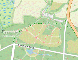 Turn left onto the lane and then immediately bear right onto a bridleway. Follow this up to a house and all the way round its garden to the other side. Join its driveway and follow it out to the A283. Cross over and bear right onto a permissive bridleway which crosses a lane and enters a wooded part of Wiggonholt Heath. Keep right, staying close to a car park on the right, to come to the RSPB Visitor Centre at Pulborough Brooks.
- Turn left briefly onto the lane, leaving the WSLT. Immediately bear right onto a long driveway, signposted as a public bridleway and heading NW. In 600m ignore a footpath off to the right. A large garden containing a long narrow pond comes into view on your left. At the far end the bridleway crosses a stream and swings round to the left to go back along its other side.
-
In 150m follow the bridleway round to the right, joining a driveway. This climbs gently and in 300m comes out onto the A283. Cross the main road carefully and take the permissive bridleway just off to the right into a wooded part of Wiggonholt Heath.
Older maps call it Wiggonholt Common, but the RSPB have been restoring the area to its original heathland habitat and now use this more descriptive name.
- Follow the bridleway round to the right, running parallel to the main road. After it turns left go straight across a minor road into more woodland, where the path is less clearly defined.
- Unless you want to explore more of the heathland, stay near the right-hand edge of the wood. You will be able to glimpse the RSPB's overflow car park off to your right as you pass its “Wild Playground” on your left.
-
After continuing along the edge of the wood for about 100m keep ahead at a path crossing, but in a further 50m turn right
at an RSPB sign for the Visitor Centre into a small car park. The Visitor Centre is ahead on your left, with a side entrance to the tearoom on the left-hand side of the building.
-
If you are an RSPB member (or pay the small entrance fee) you can visit the reserve and its bird hides. If you do this, make your own way to Little Hanger hide and complete the directions in §N.
-
If you are an RSPB member (or pay the small entrance fee) you can visit the reserve and its bird hides. If you do this, make your own way to Little Hanger hide and complete the directions in §N.
- West Lodges to Pulborough Brooks direct (2¼ km)
-
Continue north on Rackham Street until it comes to a T-junction. Go straight ahead onto a bridleway into Wiggonholt Heath and (for the most direct route) follow it for 400m to a Y-junction. Fork left onto a path leading up to the RSPB Visitor Centre at Pulborough Brooks.
-
Continue on this quiet road for nearly 1½ km, heading N. Halfway along there is an unusual round house behind the hedge on your right, where the road bends slightly right. Eventually you come to a T-junction where you go straight across Greatham Lane onto a bridleway, entering Wiggonholt Heath.
…
-
Unless you want to explore the area in more detail stay on the main bridleway as it curves gradually round to the right, with woodland on the left and soon with open heathland on the right.
- You could detour through a gate on the left into Black Wood; there is a viewpoint over the water meadows at the edge of the wood and the woodland path rejoins the bridleway further along.
- You could detour through one of the gates on the right into the main part of Wiggonholt Heath, perhaps following the RSPB's Heathland Trail to reach the Visitor Centre.
-
On the direct route the bridleway comes to a Y-junction with a three-armed footpath sign after 400m, where you fork left to go up a slope. At the top turn left
…
- …
- Through Pulborough Brooks on the right of way (1 km)
- Turn left off the Visitor Centre's access road onto a footpath leading to Wiggonholt church. Turn left onto a track going down to the RSPB reserve and stay on the right of way running diagonally across it.
- Leave the Visitor Centre and briefly take the access road leading out of the main car park. Almost immediately, turn left onto a public footpath signposted to the Church, heading N between hedges. The path dips through a more open area and then climbs back up to the hamlet of Wiggonholt.
- At the top turn left onto a broad grassy strip in front of the tiny Wiggonholt church?. Follow the grassy path past its lychgate and downhill. In 250m keep ahead across the perimeter path around the RSPB reserve, going through a wooden kissing gate onto a fenced grassy track alongside a field.
- At the far end turn half-right as indicated and go diagonally across the next field on a broad grassy path. In the far corner go through a gate to come to a path junction, with a wide chalky track on the other side of the perimeter path.
- Pulborough Brooks to Pulborough Station (3 • 2¾ km)
-
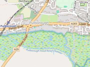 Leave the RSPB reserve in its north-western corner on a footpath going across the water meadows to the River Arun. Turn right and go along its embankment for 600m. After crossing the River Stor keep ahead towards houses and go up a lane to the A283. Turn left and go along the main road for 300m.
- For the quieter main route, go up a ramp on the right and across a meadow to Old Rectory Lane. Turn left to go past the Chequers Hotel, across the A29 and along Church Place. Just before a railway bridge, turn left onto a footpath leading to Pulborough station.
-
For a more direct route, go all the way through the village on the A283 (passing Macklin's Bar at the junction with the A29) and veer right up the station approach road.
- From the path junction near Little Hanger hide leave the reserve on a wide chalky track going downhill. At the bottom follow it round to the right and go through a kissing gate beside a fieldgate into Pulborough Brooks?. Continue on a broad and slightly elevated grassy path across these water meadows, heading NW. At the far end veer right onto a path climbing a low embankment and turn right to go along it, with the River Arun off to your left.
-
In 600m the path veers left off the embankment and crosses the River Stor on a footbridge. From the top of another embankment take the left-hand of two signposted footpaths across a large meadow, a grassy path heading N towards houses on the outskirts of Pulborough.
- Continue alongside a water channel and then gently uphill to the far side of the meadow. Go through a new wooden gate and up a narrow lane to the A283 (Lower Street), with The Pulbrew coffee shop directly opposite.
- Unless you want to detour to the Oddfellows Arms (100m along the A283 to the right) turn left onto the road, heading W. In 300m, just after passing Skeyne Drive on the left, there is a pedestrian ramp off the right-hand side of the main road.
-
Main route
- Cross the main road carefully and go up this ramp (or the steps opposite Allfreys Wharf a little further along). At the top go through a gate into a meadow and follow the tarmac path uphill and round to the right to reach Old Rectory Lane.
-
Turn left onto the lane, with a fine view of the South Downs off to your left. Just before reaching the A29 you pass the (probably closed) Chequers Hotel on the right. Cross the busy main road with great care and go straight ahead into Church Place, passing St Mary's church? up on the left.
- You could detour through the churchyard but the church itself is usually locked after 4pm.
- In 250m, just before the railway bridge, turn left onto a tarmac path (the start of the Main Walk) leading to Pulborough station. If the ticket office is closed, make your way around the left-hand side of the station building onto Platform 2. Go under the tunnel to Platform 1 for trains to London.
-
Direct route (−¼ km)
- Carry on along the A283. In 400m you come to a pair of mini-roundabouts where the A283 crosses the A29, with Macklin's Bar on the left-hand side.
-
Make your way onto the continuation of the A283 (Station Road). The station approach road is on the right in a further 300m.
…
- The Wey-South Path runs for 58 km between Guildford and Houghton Bridge. It follows the route of the River Wey, the River Arun and the canal linking them.
- Park Mound on the right of the bridleway is the site of a motte and bailey fortress, built shortly after the Norman Conquest.
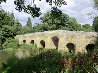
- Stopham Bridge was built in 1423, replacing an earlier wooden bridge. The central arch was raised in 1822 to allow barges to pass. The bridge was still being used by traffic until the new A283 road bridge was constructed alongside in 1986. It is a Scheduled Monument and listed Grade Ⅰ.
- Greatham Bridge was built in the early 14thC, although it was reconstructed in the 1790s and the iron spans are a replacement for sections damaged by flooding in 1838. It was the site of a skirmish in the English Civil War when local Royalists tried to defend the river crossing. It is a Scheduled Monument and listed Grade Ⅱ.
- Amberley Wildbrooks Nature Reserve consists of 82 hectares of grazing marshland, dissected with numerous ditches dug in the 19thC to assist drainage. It is owned by the Sussex Wildlife Trust and managed in partnership with the RSPB and other local landowners.
- St Michael, Amberley is Norman, with the nave and chancel arch dating from about 1100. There are medieval wall paintings to the right of the arch. The church was enlarged in 1230 and much altered in a Victorian restoration.
- Amberley Castle was built as a palace for the Bishops of Chichester soon after the Norman invasion. It was owned by a prominent Royalist in the Civil War and partly destroyed by Parliamentary forces. It is now a luxury hotel.
- The South Downs Way runs for 161 km along the length of the South Downs, from Winchester in Hampshire to Eastbourne in East Sussex.
- Although it looks medieval, Houghton Bridge was actually constructed in 1875.
- The Amberley Museum and Heritage Centre is “dedicated to preserving the industrial heritage of the South East”, with over 40 exhibits and a team of craftsmen demonstrating traditional skills.
- The Monarch's Way is supposedly the escape route taken by the future King Charles Ⅱ after his defeat by Parliamentary troops at the Battle of Worcester in 1651. It is the longest inland trail in England, running for 990 km from the battlefield to Shoreham-by-Sea.
- South Stoke Barn dates from 1860, one of several elaborate agricultural buildings on the Duke of Norfolk's estate. An attached water tower supplied the village before its connection to the mains in 1960. It was built as a granary but has been adapted for concerts and plays, and is now predominantly a wedding venue.
- St Leonard, South Stoke dates from the 11thC. The unusual spire was added in a 19thC restoration.
- The Gurkha Bridge over the meander at North Stoke was repaired and restored by the Queen's Gurkha Engineers in 2009.
- St Mary the Virgin, North Stoke dates from the 11thC. It is no longer used for regular services, but is maintained by the Churches Conservation Trust. Knowledge of its original dedication to St Mary was lost for centuries and only rediscovered in 2007.
- The West Sussex Literary Trail runs for 87 km between Chichester Cathedral and Horsham. Its 2007 guidebook “brings the walk alive with stories of the many and varied literary connections along the way”.
- Rackham Old School closed in 1945. This Victorian building is leased by the Parham Estate to a local community association.
- Parham House is a Grade Ⅱ listed Elizabethan manor house, with a large Walled Garden and 18thC Pleasure Grounds. To the south of the house, St Peter's church dates from the 12thC and has interesting box pews and Gothic revival features.
- The Queen's Green Canopy plaque commemorates a short avenue of lime trees planted for Her Majesty's Platinum Jubilee in 2022.
- Wiggonholt church (which is undedicated) has some original walls dating from around the 12thC.
- Pulborough Brooks Nature Reserve is owned and managed by the Royal Society for the Protection of Birds (RSPB). The 160 hectares of water meadows had become drier after engineering works to the river in the 1960s, but the RSPB have restored the original wetland habitat by controlling the water levels.
- St Mary, Pulborough dates from the 13thC. It has a ‘weeping chancel’ (one not in line with the nave), although this might have been a mistake when the church was extended in the 15thC.
If you are doing the Main Walk, go to §H.
The route from Amberley village is the same as the ending of Walk 1–32.
If you doing the Alternative Short Walk (omitting South Stoke), complete the walk with the directions below.
The suggested route to Amberley station follows the Walk 1–32 route on the far bank: the riverside path there is nicer but you do have to recross the river on an awkward road bridge. If you prefer you could remain on the left-hand bank; this path leaves the embankment after 400m and goes behind some park homes to reach the B2139.
The main route goes via an interesting Victorian building, but if you wish you can take a slightly more direct route through the wood in [?].
If you are taking the short cut to Pulborough Brooks (omitting Parham Park), go to §L.
There is a choice of routes. If you are not visiting the Crown Inn in Cootham you could take the more interesting route in [?], where you will usually be able to watch gliders being towed or winched into the air, and landing.
To continue the walk on the right of way through the reserve, go to §M.
If the Chequers Hotel has closed the only remaining refreshment place before the station is on the direct route through the centre of the village on the A283 in [?].
Walk Notes
» Last updated: July 27, 2024
Return to Top | Walk Map | Walk Options | Walk Directions.