Thames Path: Putney to Richmond walk
Tree lined Thames Path past Hammersmith and Kew with many riverside pubs.


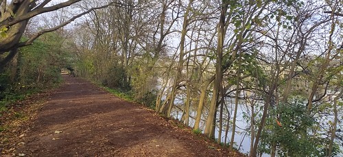
IMG_20211129_121302
Between Kew and Chiwick Bridges
Nov-21 • Andrew Murphy on Flickr
swcwalks swcwalk390 51714391844

IMG_20211129_121737
District Line Rail Bridge
Nov-21 • Andrew Murphy on Flickr
swcwalks swcwalk390 51713729721
IMG_20211129_121927
Thames footpath near District Line bridge
Nov-21 • Andrew Murphy on Flickr
swcwalks swcwalk390 51713729351
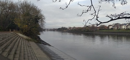
IMG_20211129_123246
Thames near Chiswick Bridge
Nov-21 • Andrew Murphy on Flickr
swcwalks swcwalk390 51714599155

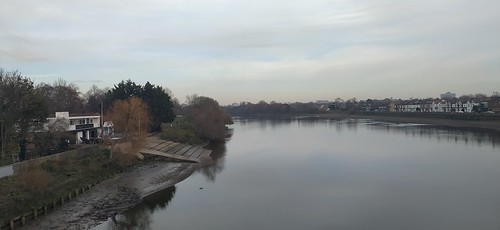
IMG_20211129_125546
Thames from Chiswick Bridge
Nov-21 • Andrew Murphy on Flickr
swcwalks swcwalk390 51713995098
| Length | 9.3 miles (15.0 km) over all weather paths with no ascent. About 3.5 hours walking time. The north bank is 2km longer due to river curves and inland diversions |
|---|---|
| Map | OS Explorer 161 - London South (or Google Maps) |
| Toughness | 1 / 10 (flat, hard, all weather surfaces) |
| Features |
This walk follows a pretty section of the Thames Path as it winds through west London. It passes 10 bridges, 8 of which you can cross. You can choose between north bank (wealthy suburbs with riverside pubs) and south bank (more rural) paths between each bridge. The walk can be done in either direction, both Putney and Richmond have a nice selection of riverside pubs and cafes. There are also many along the way, especially on the north bank. You can cross 8 of the bridge you come to, just going to the middle for the view, or alternating from side to side if you wish. Only 2 of the 'sides' need be avoided due to inland detours around missing sections of riverside path - see directions below. The 2 you cannot cross (marked in the directions) are Richmond and Kew Railway Bridges. The south bank path in particular is wide and easy walking - you'll make good time. The north bank path has a better selection of pubs. This makes a fine winter walk - best to do it without stopping to make the most of the winter sunlight, and eat at the end. Walk #swc261 follows the north bank from Barnes Bridge to Putney, and visits Chiswick Park which is about 500m 'inland' from the river. |
| Travel |
Putney Bridge (tube) is on the District Line. Putney (rail) has regular trains to Waterloo Richmond is on the District Line, and has regular trains to Waterloo The walk passes several tube and train stations, and many bus stops. Drivers should note that most areas are in 'CPZ'. Check online first using Google Maps Streetview to look at parking signs. Weekends should be OK, south bank and west better than north bank and east (except around Richmond). Weekdays would be very difficult to find parking. There are regular direct trains from Putney (rail) station to Richmond to return to your car. |
| Eat |
Far to many riverside pubs and cafes to mention them all. Mainly on the north bank, with a gap from Kew Bridge to Richmond. A few are mentioned in the text. Near Putney Bridge
Near Richmond Bridge
|
| Attractions |
By Putney Bridge
Between Hammersmith and Barnes Rail Bridge (north bank)
Near Kew Bridge
|
| Bridges |
|
| Thames Path |
This walk is part of the Thames Path [wikipedia] [National Trails] - a 184 mile national long distance path - that follows the Thames from its source in Kemble to the Thames Barrier at Charlton in SE London. There is an unofficial 10 mile south bank extension on to Crayford Ness. It follows the river's historic towpath where possible. In a few places, nearby paths are used instead as towpath sections do not match up where former "horse ferry" crossing have been lost. Through London, and on to the sea, there are north and south bank paths. |
|---|---|
| Profile | |
| Help Us! |
After the walk, please leave a comment, it really helps. Thanks! You can also upload photos to the SWC Group on Flickr (upload your photos) and videos to Youtube. This walk's tags are: |
| By Car |
Start SW6 3UH Map Directions Finish Richmond Map Directions |
| Amazon | |
| Help |
National Rail: 03457 48 49 50 • Traveline (bus times): 0871 200 22 33 (12p/min) • TFL (London) : 0343 222 1234 |
| Version |
Apr-24 Andrew |
| Copyright | © Saturday Walkers Club. All Rights Reserved. No commercial use. No copying. No derivatives. Free with attribution for one time non-commercial use only. www.walkingclub.org.uk/site/license.shtml |

Walk Directions
#0 Putney Railway Bridge to Putney Bridge - 0.3km
South Bank (recommended - an extra bridge and riverside pubs)
From Putney Bridge tube station (District Line) : turn left outside the entrance and take a narrow path alongside the tracks down to the river. Cross the river on the railway bridge path, then turn right, soon passing a Wetherspoons and a church, towards Putney Bridge.
North Bank (recommended)
From Putney Bridge tube station (District Line) : go straight on towards Putney Bridge
#1 Putney Bridge to Hammersmith Bridge - 2.5km
From Putney train station (to/from Waterloo) : turn right, and walk along the main road, past shops and cafes, to the bridge.
South Bank (recommended - more rural)
- St Mary's church is by the bridge. A couple of pubs with riverside seating are behind it.
- Pass the Start and Garter pub.
- Follow the riverside path, past a nice suburb, then rural (passing the London Wetlands Centre), then another wealthy suburb
North Bank (recommended - Bishop's Palace and Park)
- All Saints church is by the bridge.
- Pass Bishop's Palace (former home of the Bishop of London). Free entry. Nice grounds and garden tea room.
- Pass Bishop's park, an urban park, with toilets and a park cafe (The Tea House at Bishop's Park)
- Pass Craven Cottage, Fulham's football ground (short inland detour to be replaced summer'21 by a riverside path)
- Follow the wide pedestrian embankment
- Just before Hammersmith Bridge are the Blue Boat (pub) and Riverside Studios (art complex, probably with a pub/cafe to come)
#2 Hammersmith Bridge to Barnes Railway Bridge - 2.5 km
South Bank (recommended - more rural)
- A mostly rural tree lines section
North Bank (recommended - elegant suburbs and riverside pubs)
- A paved riverside path past expensive houses, with some short sections with no river view.
- The Blue Anchor and Rutland Arms are busy pubs right by the bridge
- Pass Furnivall Gardens (urban park), The Dove (pub), and the William Morris Society (museum)
- Pass the Old Ship (pub) and Upper Mall (park)
- Pass Emery Walker Trust (museum) on a short stretch with no river view
- Pass Chiswick Eyot (island) and the Griffin Brewery (pub)
- Pass Dukes Meadows (a park)
#3 Barnes Railway Bridge to Chiswick Bridge - 1.2 km
There are actually 2 bridges. The original one (unused, it was replaced after a bridge of similar design failed, but there are plans to make it a "green way"), and the current one which has a pedestrian footbridge.
In 2023, a new section of path opened on the North Bank - a bridge over the river but under the railway bridge. This saves a 500m out-and back diversion inland on the north bank towpath.
South Bank (recommended)
- A quiet wealthy suburb, passing the White Hart (a well known jazz music pub)
North Bank (recommended, rural apart from short inland detour at finish)
- There is a short inland detour at the start, but a riverside walkway is currently (2021) under construction to avoid it
- A rural path alongside Dukes Meadow, with a short inland detour at the end
#4 Chiswick Bridge to Kew Bridge - 1.7 km
This section passes Kew Railway Bridge with no pedestrian path.
South Bank (recommended)
- A pleasant semi-rural section
North Bank (not recommended - streetwalking with no views)
- 2 sections, first 100m then a longer 800m section of pavement walking along a busy road with no river view - about half the total
#5 Kew Bridge to Richmond Lock - 3.4 km
There's an entrance to Kew Gardens near Kew Bridge
South Bank (recommended)
- A pleasant rural section passing Kew Gardens and Old Deer Park (golf course), but you can't see either because of trees.
North Bank (avoid - interesting at first, then a long inland detour)
- After a riverside stretch, there is a detour along following the start of the Grand Union Canal. Check for recent path improvements as the result of new buildings.
- Then their is a long 1km inland detour on a quiet road around the perimeter of Syon House, a large country house (worth visiting, its in the Historic Houses Association).
- The end of it, through Isleworth, has lovely river views - its on the 'outside' of a long curved section with far reaching views over Isleworth Ait (island). There's another short inland detour.
- Its actually worth doing the south bank path, then walking back from Richmond Lock towards Isleworth for the view
#6 Richmond Lock to A316 Bridge - 0.4 km
This is a short stretch, either side is fine
#7 A316 Bridge to Richmond Bridge - 0.6km
Avoid crossing the A316 Bridge, although safe (pavement), its a busy trunk road
This section passes Richmond Railway Bridge, which has no pedestrian access
South Bank (recommended)
- Pretty with riverside bars. This section sometimes floods for a short while at very high tides
North Bank (OK)
- Inland, with restricted river views
Richmond
Richmond is an upmarket suburb with fine houses and expensive cafes, pubs and restaurants.
From the Bridge, turn left, follow the road past the shopping area to the station. There are quieter streets and a green to your left.