West Byfleet to Hampton Court walk
The Wey Navigation and the Thames Path via several pubs.

CIMG2670
The Wey Navigation at Weybridge
Feb-16 • Sean O'Neill
swcwalk45, swcwalks, walkicon 6248683591670075554 P
CIMG2676
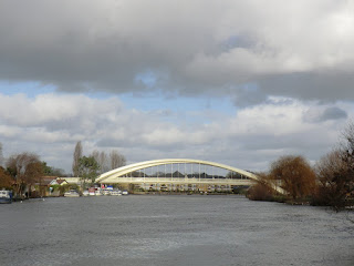
Approaching Walton Bridge
Feb-16 • Sean O'Neill
swcwalk45, swcwalks, walkicon 6248684425808109058 P


Invincible
Canal boats
Nov-14 • magyardave2002 on Flickr
houseboat narrowboat book3 swcwalks walk45 15287941353
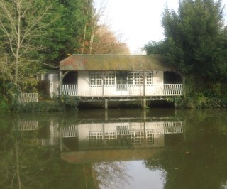
If that's a cricket pavilion,.......
..... your pitch is flooded.
Nov-14 • magyardave2002 on Flickr
book3 swcwalks walk45 15906951842
| Length |
10.7 miles / 17.2 km (with no ascent) The Extension to Kingston adds 2.5 miles / 4.1 km (with no ascent) |
|---|---|
| Toughness | 1 out of 10 (easy walking along tarmaced paths) |
| Maps | OS Explorers: 160 and 161 |
| Features |
This easy walk is very close to London. It follows the Wey Navigation (a canal), and then joins the Thames, which it follows it to Hampton Court. Navigation is simple, and there are many pubs along the walk. The entire route is marked with red chevrons on OS maps, though waymarking along the canal is poor. While the walk is flat, the path along the Wey Navigation is a bit rough in spots. While it is passable for bikes, it is narrow in places, and so not really suitable for wheelchairs or baby buggies. The Thames Path is wide, paved, and suitable for both Along the navigations is Coxes Lock, and Mill Pond. The Mill is now housing. Just after reaching the Thames you pass D'Oyle Carte Island, reached via a pedestrian bridge, which now has an (outside seating only) cafe on it. Between Walton and Hampton Court is a place where you can feed Swans (its marked) - bring stale bread - while not their ideal diet, it encourages them to stay in a specific area and much better than nothing. Hampton Court Palace gardens are no longer free (a crazy £29 including entrance to the large palace), but there is free access to the deer park from the Thames Path (past the Palace). The gardens have occasional 'free' days - see the palace website, and check the gardens page Flooding : The canal doesn't flood (the adjacent River Wey does instead), but the River Thames path may very exceptionally flood - see flood levels below. |
| Swimming |
Use extreme caution, and take local advise. Although the river seems calm, there are drownings in the Thames each year. Beware of currents, underwater inlets, being entangled, and river traffic. At a swim event near Hampton Court in 2012, a third of the 1,000 people who took part had gastrointestinal illness ('food poisoning'). In 2019, the Environment Agency stated that "the River Thames at Hurst Park is not bathing water quality, and that swimming in it comes with risks ... Human waste matter is likely ... from unauthorised live-aboard and stay-aboard vessels in the Molesey Reach ... Reports of gastro-enteritis suffered by dogs who have been in the river here suggests there may be an issue. If you have contact with river water and are ill in the days following, please let [the Environment Agency] know." "Water in the Thames .. contain[s] high levels of antibiotics from the large number of wastewater treatment works ... This result is an increasing number of antibiotic-resistant bacteria, which means if you get an infection after swimming in the river it might be ... difficult to treat. |
| Walk Options |
The station before West Byfleet is Byfleet and New Haw. The walk passes very close to it - you can even see the canal from the platforms. However, I haven't checked a 'footpath' route to the canal from this station. |
| Credit |
The idea for this walk came from the Inner London Rambler's website |
| Transport |
Catch a train from London Waterloo to West Byfleet (not Byfleet and New Haw). There are 4 trains an hour (2 fast taking about 30 mins). Buy a return to West Byfleet. Hampton Court is in Zone 6. There are 2 trains an hour taking about 30 mins to Waterloo. You may have to buy a single (or Oyster) from the 2 stops from Hampton Court to Surbiton. Suggested train: For the normal walk, the train nearest to 10:30 (summer) 10.00 (winter) from Waterloo. If you miss the train, catch the next one to Byfleet and New Haw, turn right out of the station, and walk along the road for 1km, and join the canal by a road bridge (see map for details) |
| Notes |
Hampton Court is a large Royal Palace with gardens and a maze, but you will arrive too late to do it justice. If you do go in, an audio guide is recommended The Wey Navigation opened in 1653 and was one of the first navigable rivers in the country. It survived the railway era, and was donated to the National Trust. The Basingstoke Canal (first 2 km of the walk) was built 150 years later, in 1796. The River Thames is significantly, older, dating to the late Palaeocene Period. Desborough Island, however, is artificial. It was created in the 1930's to improve the river's flow |
| Lunch and Tea |
The suggested itinerary is Elevenses at D'Oyle Carte Island, a picnic, then tea and cake at 8 on the river (Molesey Boat Club)
Save any spare bread for feeding the Swans |
| Thames Path |
This walk is part of the Thames Path [wikipedia] [National Trails] - a 184 mile national long distance path - that follows the Thames from its source in Kemble to the Thames Barrier at Charlton in SE London. There is an unofficial 10 mile south bank extension on to Crayford Ness. It follows the river's historic towpath where possible. In a few places, nearby paths are used instead as towpath sections do not match up where former "horse ferry" crossing have been lost. Through London, and on to the sea, there are north and south bank paths. |
|---|---|
| River Levels |
River Thames from Weybridge to Hampton Court |
| Profile | |
| Help Us! |
After the walk, please leave a comment, it really helps. Thanks! You can also upload photos to the SWC Group on Flickr (upload your photos) and videos to Youtube. This walk's tags are: |
| By Train |
Out (not a train station) Back (not a train station) |
| By Car |
Start KT14 6DY Map Directions Return to the start: Finish KT8 9AE Map Directions Travel to the start: |
| Map Walk | This walk requires an OS map and a compass or GPS for navigation. You can print out OS maps using the link above. |
| Amazon | |
| Help |
National Rail: 03457 48 49 50 • Traveline (bus times): 0871 200 22 33 (12p/min) • TFL (London) : 0343 222 1234 |
| Version |
Apr-24 Andrew |
| Copyright | © Saturday Walkers Club. All Rights Reserved. No commercial use. No copying. No derivatives. Free with attribution for one time non-commercial use only. www.walkingclub.org.uk/site/license.shtml |


Walk Directions
This walk is a very easy, just follow the canal, then the river, the only bit that needs directions is the bit in the middle through Weybridge!
West Byfleet to Weybridge via the Wey Navigation (canal)
- Take the north exit from West Byfleet Station (The Station pub side), and turn left, and follow the road round. When the road turns left, continue straight on, to the right of a car park, and continue to the lock (about 250m in total).
- Turn right (east) along the canal. Continue for 2km.
- At the canal junction (by the M25), cross the bridge, and turn left (north)
- In theory you could start from Byfleet and New Haw Station - you can see the canal from the platforms, about 200m away! If you head north, along the road from the station for 800m, you meet the canal at a road bridge, about 800m away as the canal and the road converge. It might be possible to walk directly to the canal (which is adjacent to open land at this point), and avoid any road walking, by walking parallel to the tracks to the canal junction, but I haven't checked to see if it possible.
- Continue along the canal for 3km to the outskirts of Weybridge, passing New Haw lock (with the White Hart pub on the opposite bank) and Coxes Lock (with an old mill building and a picturesque mill pond on the opposite bank).
Weybridge
- You come to a 'canal junction'. ! Turn left, and cross a road parallel to the canal, to continue along the canal. [!] Ignore the public footpath sign. Do not go straight on and cross the '1 way traffic' road bridge.
- Aross the '1 way' bridge is Weybridge town centre, and 1km along a busy road (pavement) is Weybridge Station
- This section ('Weybridge') is all a bit narrow for cyclists, who need to do a slightly longer inland route, crossing the '1 way' bridge (see the OS map for details).
- Pass some new flats, and go under the large road bridge.
- Continue along the canal to the lock with a 'National Trust' hut and some NT information panels.
- Cross the lock bridge to the other side of the canal, and follow the path (with streetlights). Cross a small road, and continue along the unlit path, over another bridge, and come to houses and a lane.
- Turn left on narrow Church Walk, cross a narrow road, and continue along the lane (now a path, not a lane) to come out on Thames Street by the Old Crown pub (recommended).
Weybridge to Walton to Molsey to Hampton Court via the Thames
- Follow the Thames east (towards London), passing D'Oyle Carte island (and recommended cafe), 2 small bridges to Desborough Island, and eventually, the larger Walton Bridge (2km)
- Continue, passing The Swan (recommended) and The Anglers (riverside location), and 1km further, The Weir (riverside terrace) pubs (2km total)
- Continue. Pass a reservoir, and eventually come to a park with a sign allowing the feeding of swans (bring bread!). Pass an island with houseboats, a boathouse (the 8 on the River cafe), and eventually reach Hampton Court Bridge (5.5 km)
Hampton Court
- Hampton Court Station is the other side of the road.
- Across the bridge is the The Mitre Hotel pub for tea, as is Hampton Court Palace (gardens free in winter). Just round the corner from The Mitre, is the Cardinal Wolsey
Hampton Court to Kingston (Optional Extension)
- To continue to Kingston, cross Hampton Court bridge, turn right and follow the towpath along the other (north) bank.
- After 400m, enter the grounds of Hampton Court park, and head north east through the deer park. (This is much shorter and nicer route than just following the towpath)
- Exit the north east corner of the park, turn right, and in 100 metres, cross Kingston Bridge.
- Follow the high street (pedestrianised) to Kingston Station
In Reverse
Hampton Court to West Byfleet
If you do the walk in reverse, the route is as follows.
- Walk from Hampton Court (west) along the south bank of the Thames to Weybridge.
- Weybridge
- When you reach the Old Crown pub, take the path to its right (river side)
- Continue along the path, cross the first small road, continue along what is now a small road for 10m, then turn right along a path
- Cross the small bridge, then shortly a road, and continue on the path with street lights to the right of a park.
- Soon you reach a canal, cross the lock bridge and turn left along the canal past the National Trust hut.
- After a km, just after passing under a road bridge, at a road junction, cross the road and turn right along the canal (do no not turn left across the "1-way" bridge)
- Weybridge to West Byfleet
- After 2km, at a canal junction, turn right over a canal bridge
- By a lock, turn left for 250m to West Byfleet station