Rhossili via Llangennith Circular (Wales Coast Path) walk
A gentle walk, up to then along the downs overlooking a stunning beach with wide ranging sea views, and back along the beach itself.

20160829_113057
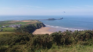
Worms Head from Rhossili Down
Aug-16 • Andrew Murphy on Flickr
swcwalks swcwalk87 29587773165
20160829_113111
Worms Head from Rhossili 2
Aug-16 • Andrew Murphy on Flickr
swcwalks swcwalk87 29477860752

20160829_113850
Worms Head from summit of Rhossili down
Aug-16 • Andrew Murphy on Flickr
swcwalks swcwalk87 29507292081

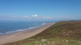
20160829_115206
Rhossili beach and Spaniards Rock
Aug-16 • Andrew Murphy on Flickr
swcwalks swcwalk87 29297532770

20160829_122534
Rhossili beach at low tide
Aug-16 • Andrew Murphy on Flickr
swcwalks swcwalk87 28962394874

20160829_135713
Rhossili beach - bottom of hill path
Aug-16 • Andrew Murphy on Flickr
swcwalks swcwalk87 29297529320
| Length | 15.3km / 9.5 miles |
|---|---|
| OS Map | OS Explorer (Gower) |
| Toughness | 3 out of 10 |
| Features |
Rhossili is a truly stunning beach, regularly on best in the world lists This easy walk starts in Rhosilli, a small village at the south west end of the Gower Peninsular, and climbs Rhossili Down (a treeless hill) behind the beach for a long ridge walk parallel to, but above, the amazing beach, with views back over Gower, and across to Pembrokeshire. At the far end of the ridge, descend to Llangennith (pub) and caravan park (cafe). The route back is along the beach itself (easy over firm sand). Tea is on the terrace of a pub on a cliff edge, with a truly stunning view overlooking the beach. |
| Lunch and Tea |
|
| Tides |
27-Jul :
low: 05:11
high: 11:26
low: 17:27
high: 23:52
28-Jul :
low: 05:56
high: 12:13
low: 18:17
29-Jul :
high: 00:44
low: 06:49
high: 13:10
low: 19:21
30-Jul :
high: 01:47
low: 07:57
high: 14:20
low: 20:41
31-Jul :
high: 03:06
low: 09:18
high: 15:45
low: 22:08
01-Aug :
high: 04:29
low: 10:38
high: 17:01
low: 23:21
02-Aug :
high: 05:35
low: 11:40
high: 17:59
Times for . Corrected for BST if appropriate. Contains ADMIRALTY® tidal data: © Crown Copyright and database right.
| ||||||||||||||||||||||||
|---|---|---|---|---|---|---|---|---|---|---|---|---|---|---|---|---|---|---|---|---|---|---|---|---|---|
| Rhossili |
Rhossili is a small village in a superb location at the southern end of Rhossili beach - the beach is regularlly on 'best in the world' lists. Behind the beach is a down (grassy hill). Beyond the village is a headland and the Worms Head islands. Eat: The Worms Head Hotel, thewormshead.co.uk - OK bar food, £4 pints, has a terrace with an absolutley stunning view of the bay. Probably the best view of any pub in the country! There's a tea room next door. By Bus: Year round bus from Swansea. Buy a bus pass. About 1 hour. Every 1 to 2 hours. Check the times before travelling, especially off season. By Car: SA3 1PP, about 45 mins from Swansea. In 2015, the National Trust brought the village car park for £3 million, raised the fee to £4 (free to members, £2 for 1 hour), and made the charges year round. There's free parking for a few cars by the church, or on the road in to town. Stay: There are several B&B's in Rhossili, and holiday rentals, besides the Worms Head Hotel. The nearest youth hostel is Port Eynon |
||||||||||||||||||||||||
| Gower Walks |
Clockwise from Swansea - Gower's beaches are exceptional - there really are this many 5 star walk here!
If you want to do the Gower Coast Path
| ||||||||||||||||||||||||
| Get There |
The nearest train station is Swansea... but its a 10 min walk from the bus station. Some early morning / late evening buses start from it though. London Paddington to Swansea : 3 hours, £80 off peak return. 'Advance' tickets (no changes) from £20 single. A good compromise is "Advance" out, and an (Open) "Single" back - about £60. London Waterloo via Salibury and Bath - £60 off peak return. Much longer. Cheap advance tickets on the few direct trains per day. Megabus (London to Swansea from £6 single) coach and National Express coach is another option. Driving to Swansea takes about 3 hours from London. The Seven bridge costs £6.60 to Wales only (free coming back). Its not worth driving around via Gloucester, even if going to the Brecon Beacons. Its a lot longer, and with the extra fuel, you wont save much | ||||||||||||||||||||||||
| Buses |
You must check the bus times beforehand - using traveline.cymru/ Why? Because times and routes vary on school days, not school days, weekdays, Saturday, Sunday, summer, winter... It might be efficient, but its confounding for visitors. There are different day bus passes for each company which are good value (about the same price as a single!), but which one you need varies by destination and day !!! Partial update: Summer 2018 Swansea bus station is about 15 mins walk from the train station. From there, 2 companies run buses to Gower, with a bizarre obfuscated schedule. There is a 'Go Gower' day pass for £5.40, valid on both companies. Notes. Mumbles official name is Oystermouth, they are the same place. Swansea, Black Pill and Mumbles are on Swansea Bay. Current routes are
New for 2018: There is a £3.50 one-way flat rate ticket for West Gower, for thoes returning to their car. |
||||||||||||||||||||||||
| Stay |
Swansea is the best place for public transport users. The city doesn't have many tourist sites except for Wind Street (pronounced Wine Street, loads of mega pubs) and the marina. Many old seafront B&B's, and mega chain hotels. Mumbles (Oystermouth) is a pretty seaside village, quieter at night and more upmarket nowadays as the 'Mumbles mile' pubs are no more. Old B&Bs and boutieque hotels. Swansea's 'latin' quarter. There is a Youth Hostel in Port Eynon, and a large beach campsite on Rhosilli beach near Llangennith. Also campsites at Three Cliffs. Rhosilli itself would be a great place to stay for car travellers. | ||||||||||||||||||||||||
| Warning |
The Severn Estuary has the second highest tidal range in the world (after the Bay of Fundy), with typically, a 30 foot (10 metre) difference between high and low tide. If you walk along the beach beneath high cliffs, or far out on the sands, be aware of that you can be cut off by a rising tide! | ||||||||||||||||||||||||
| Profile | |||||||||||||||||||||||||
| Help Us! |
After the walk, please leave a comment, it really helps. Thanks! You can also upload photos to the SWC Group on Flickr (upload your photos) and videos to Youtube. This walk's tags are: |
||||||||||||||||||||||||
| By Car |
Start Rhossili, Gower, West Glamorgan Map Directions |
||||||||||||||||||||||||
| Map Walk | This walk requires an OS map and a compass or GPS for navigation. You can print out OS maps using the link above. | ||||||||||||||||||||||||
| Amazon | |||||||||||||||||||||||||
| Help |
National Rail: 03457 48 49 50 • Traveline (bus times): 0871 200 22 33 (12p/min) • TFL (London) : 0343 222 1234 |
||||||||||||||||||||||||
| Version |
Apr-24 Andrew |
||||||||||||||||||||||||
| Copyright | © Saturday Walkers Club. All Rights Reserved. No commercial use. No copying. No derivatives. Free with attribution for one time non-commercial use only. www.walkingclub.org.uk/site/license.shtml |


Walk Directions
- Park either in the pay car park, or down the road a ways
- (from the car park) Walk back to the village centre, and up onto Rhossili Down - 193m.
- Walk north, above the beach as far as you wish
- If desired, continue as far as Llangennith and its pub, then down to the beach and Burry Holme/Spaniards Rock (both points easily visible from the downs)
- Walk back along the beach
- Climb up the cliff path and have a well deserved drink in Rhossili's pub