River Crane walk

River walk through west London parks, woods, and nature reserves.

river-crane-park
river-crane-park

Feb-21 • Andrew Murphy on Flickr

swcwalk376 swcwalks 50996510052

IMG_20210226_130133
IMG_20210226_130133

Feb-21 • Andrew Murphy on Flickr

swcwalk376 swcwalks 50996405951

IMG_20210226_131414
IMG_20210226_131414

Feb-21 • Andrew Murphy on Flickr

swcwalk376 swcwalks 50996405146

river-crane-island-nature-reserve

Feb-21 • Andrew Murphy on Flickr

swcwalk376 swcwalks 50996518947

IMG_20210226_131956
IMG_20210226_131956

Feb-21 • Andrew Murphy on Flickr

swcwalk376 swcwalks 50995709833

river-crane-shot-tower

Feb-21 • Andrew Murphy on Flickr

swcwalk376 swcwalks 50996391416

IMG_20210226_132003
IMG_20210226_132003

Feb-21 • Andrew Murphy on Flickr

swcwalk376 swcwalks 50996403346

Length 5.7 miles / 9.2 km (one way), double that to return
Toughness 2/10, flat, a mix of forest paths and paved all-weather surfaces
Map OS Explorer
Walk Details

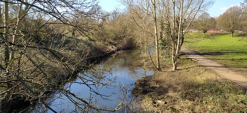
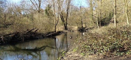
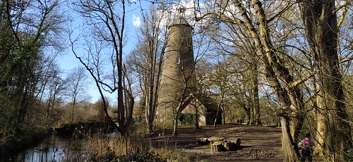
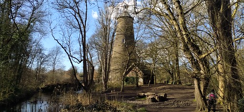
This walk follows the River Crane through west London through a mixture of urban parks and surprisingly rural woods and forests.

The walk can be out-and-back (recommended, there are north and south bank paths in many places), or linear (return by bus, or by bus to train station). Either way, you can do a long or short walk to please.

The route passes through Twickenham Junction Roughs, Craneford Way Park, Mereway Nature Park, Kneller Gardens (park cafe!), Crane Park (I), Willow Way Park, Crane Park (II), Crane Island Nature Reserve, Pevensey Road Nature Reserve / Letrim Park, Hounslow Heath, Brazil Mill Woods, Donley Wood, and Causeway Park.

En-route, by the island nature reserve in Crane Park, is a Brick (Shot) Tower. Before bullets and rifled barrels, lead shot was made by dropping molten lead into a tower containing water to make perfect spheres.

Options
  • There is a sister walk, #swc375 a circular walk around the River Crane, the Duke of Northumberland's river and the Thames
  • There are optional detours to Hounslow Heath (a mix of open space and scrub land ) and the Hanworth (Air) Park, both sadly neglected, without even a web page or park map on the Hounslow Council website. If you continue south from Hanworth Park, note that Kempton Park Reservoirs Nature Reserve is private land (Thames Water) which is not open to the public unless you join its friends scheme in advance.
  • The River Crane Path does continue further north, but you have to walk east along the busy Great West Road for 500m to a roundabout, then 500m back along the other side (on quieter Earhart Way), then you're good, apart from a gnarly bit around the M4, as far as Hays and Harlington station.
  • Don't try starting from the mouth of the Crane on the Thames - the River Crane passes through back gardens and some private allotments, and you have to zigzag around them along residential roads, and make 1 very dangerous road crossing of a dual carriageway. You could start a little earlier at St Margaret's station, and join the River Crane path from there.
  • You could continue through Twickeham, and follow the Thames east passing Marble Hill House to Richmond (don't go west - no towpath - its mainly street walking)
  • You could start at Hatton Cross and do a linear walk. There's about 1km of road walking at the start.
Travel

Trains from London Waterloo (and Clapham Junction) go to Twickenham (Zone 5) every 15 mins, and take about 30 mins.

By car, to avoid CPZ, park near TW2 6NA, and walk along the River Crane path to join the walk. On rugby match days, when parking will be difficult, park at the other end, and do the walk in reverse.

If you do a 1-way walk, some bus stops are marked. TFL bus #490 runs from Hatton Cross to Twickengham (by the river) every 12 minutes, and takes 40 mins. If you carry on to Richmond, take the tube, changing at Turnham Green and Acton (much eaiser than it sounds).

  • From Hounslow Road, cross the road, and walk left for a bus stop to Hounslow (tube and centre). From the centre, there are buses to Twickenham Station for drivers
  • From Great South West Road, walk left for a bus stop to Hatton Cross tube, with buses back to Twickenham.
Eat

There is a park cafe in Kneller Gardens quite close to the start.

Notes
Profile
Help Us!

After the walk, please leave a comment, it really helps. Thanks!

You can also upload photos to the SWC Group on Flickr (upload your photos) and videos to Youtube. This walk's tags are:

swcwalks
swcwalk376
By Train

Out (not a train station)

Back (not a train station)

By Car

Start TW1 1BD Map Directions

Amazon
Help

National Rail: 03457 48 49 50 • Traveline (bus times): 0871 200 22 33 (12p/min) • TFL (London) : 0343 222 1234

Version

Jan-23 Andrew

Copyright © Saturday Walkers Club. All Rights Reserved. No commercial use. No copying. No derivatives. Free with attribution for one time non-commercial use only. www.walkingclub.org.uk/site/license.shtml

Walk Directions

The directions for this walk are also in a PDF (link above) which you can download on to a Kindle, tablet, or smartphone. OpenStreetMap (not OS) mapping is used in the PDF for licence reasons.

Walk Map
Walk Map
© Saturday Walkers Club. All Rights Reserved. No commercial use. No copying. No derivatives. Free with attribution for one time non-commercial use only. www.walkingclub.org.uk/site/license.shtml