Rye Figure of 8 walk
Three rivers, two castles, and a coastal nature reserve in two linked circular walks.

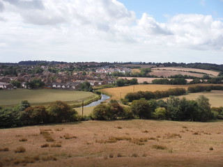
Camber Castle across the marshes
SWC Walk 365 - Rye Figure of 8
Aug-20 • thomasgrabow on Flickr
swcwalks swcwalk365 banner 50262580098
River Tillingham with northwesterly parts of Rye
SWC Walk 365 - Rye Figure of 8
Aug-20 • thomasgrabow on Flickr
swcwalks swcwalk365 walkicon 50263426587
![River Rother in northerly direction, from just north of railway bridge, Rye SWC Walk 365 - Rye Figure of 8 [Long Version]](https://live.staticflickr.com/65535/50263240736_5ecdd9f442_n.jpg)
River Rother in northerly direction, from just north of railway bridge, Rye
SWC Walk 365 - Rye Figure of 8 [Long Version]
Aug-20 • thomasgrabow on Flickr
swcwalks swcwalk365 walkicon 50263240736

A House in Rye
SWC Walk 365 - Rye Figure of 8
Aug-20 • thomasgrabow on Flickr
swcwalks swcwalk365 walkicon 50262581388
![View along coast to Fire Hills, Rye Harbour NR SWC Walk 365 - Rye Figure of 8 [Long Version]](https://live.staticflickr.com/65535/50263422172_5b2c8dd05a_n.jpg)
View along coast to Fire Hills, Rye Harbour NR
SWC Walk 365 - Rye Figure of 8 [Long Version]
Aug-20 • thomasgrabow on Flickr
swcwalks swcwalk365 walkicon 50263422172
![View along coast to Rainfront, Rye Harbour NR SWC Walk 365 - Rye Figure of 8 [Long Version]](https://live.staticflickr.com/65535/50263237096_cce2a5b87c_n.jpg)
View along coast to Rainfront, Rye Harbour NR
SWC Walk 365 - Rye Figure of 8 [Long Version]
Aug-20 • thomasgrabow on Flickr
swcwalks swcwalk365 walkicon 50263237096
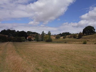
By the Tillingham River: Leasam Hill ahead, Ryw Hill on the right
SWC Walk 365 - Rye Figure of 8
Aug-20 • thomasgrabow on Flickr
swcwalks swcwalk365 50263241561
| Length |
Main Walk: 21 km (13.0 miles). Four hours 40 minutes walking time. For the whole excursion including trains, sights and meals, allow at least 10 hours. Long Walk, extended via Iden: 25¾ km (16.0 miles). Six hours walking time. Short Walk, omitting Rye Harbour: 14½ km (9.0 miles). Three hours 15 minutes walking time. Harbour Walk, omitting Playden: 16½ km (10.3 miles). Three hours 35 minutes walking time. |
|---|---|
| OS Map |
Explorer 125. Rye, map reference TQ919205, is in East Sussex, 15 km NE of Hastings. |
| Toughness |
3 out of 10 (5 for the Long Walk, 2 for the other options). |
| Features |
Perched on its sandstone outcrop, the medieval hilltop town of Rye was an important member of the Cinque Ports confederation. However, great storms in the 13thC changed the coastline in this part of the south-east and the town now lies 3 km from the sea, at the confluence of three rivers. A small fishing fleet at Rye Harbour maintains the town's tenuous link with the sea, and the many places with ‘salt’ in their name testify that it was once a centre for preserving the catch. The walk consists of two loops around the town in a Figure-of-8, with stretches alongside all three rivers. The northern loop is across the undulating Wealden countryside between the Tillingham and Rother rivers, a varied landscape of sheep pasture, arable farmland and orchards, ending with a riverside stretch on the edge of Walland Marsh. The southern loop has a completely different character, taking in part of the large area of reclaimed land between the Brede and Rother rivers designated as Rye Harbour Nature Reserve, “a mosaic of shingle, saltmarsh, saline lagoons, coastal grazing marsh, freshwater gravel pits and reedbeds”. In between, the town's historic centre (known as the Citadel) has so many attractive buildings that there is an extra loop around its cobbled streets to appreciate them. The walk also reveals the threats of invasion over many centuries, a consequence of Rye's vulnerable location on the English Channel. In the town itself Ypres Tower (jocularly pronounced Wipers) and the Landgate are remnants of its fortification against French raids in the Hundred Years War. The same enemy also led to the construction of forts such as Camber Castle in the Tudor period and many Martello Towers in the Napoleonic era. Concrete blockhouses and pillboxes scattered around Rye Harbour are reminders of a different enemy in the last century. If you are not in a hurry Rye has several visitor attractions which are worth considering:
|
| Walk Options |
The Long Walk extends the morning section by taking in more of the undulating countryside north of the town, going out as far as the village of Iden before looping back (in another Figure-of-8) via Playden. If you want to spend more time exploring Rye the Short Walk cuts out most of the afternoon section, only venturing as far as Camber Castle and Castle Water. The loops making up these options could be switched around or even done separately as half-day walks. The Harbour Walk is essentially the full afternoon section with an optional short loop over Rye Hill at the end for variety. This extension duplicates part of the Long Walk but it also makes a worthwhile addition to the Short Walk. |
| Transport |
Rye is between Ashford International and Hastings on the “Marshlink Line”, which has an hourly off-peak service. From London, it is much quicker to travel via Ashford on the High Speed Train from St Pancras, taking 65-70 minutes. You can also travel on the regular services from Charing Cross or Victoria, but the journey time via Ashford (or Hastings) is up to an hour longer. There are two useful bus routes in the area (both Mon–Sat). On the morning leg of the Long Walk Stagecoach 312 goes through Iden, and if you wanted to end the walk in Rye Harbour you could take Stagecoach 313 back to the town. If driving, the station car park costs around £3.50 Mon–Sat, £4 Sun & BH (2024). |
| Suggested Train |
For most options, take the train nearest to 09:30 from St Pancras to Rye, changing at Ashford International. For the Long Walk, leave an hour earlier unless you are planning to stop for lunch in Iden. |
| Train Times |
|
| Timetables |
|
| River Levels |
|
| Lunch |
There are many pubs and other eateries to choose from in Rye (after 7 km on the Main Walk, 11¾ km on the Long Walk), including historic establishments such as the Mermaid Inn (01797-223065). The pub originally suggested was the 17thC Ypres Castle Inn (01797-223248; open Thu–Sun & BH Mon) – partly because of the fine views across the marshland from its beer garden – but it no longer does hot food, tea or coffee. However, as the town is so compact you should be able to find somewhere suitable without too much difficulty. Any feedback about possible lunch places on this walk's Comments page would be welcome. On the Long Walk an earlier stop (after 6½ km) might be possible at The Bell at Iden (01797-280242), but this is reported to be temporarily closed. On the Harbour Walk the suggested lunch stop (after 9¾ km) is the William the Conqueror pub (01797-223315) in Rye Harbour village, which specialises in Greek Cypriot dishes. |
| Tea |
There are many tearooms, coffee shops and cafés in Rye, not to mention all its pubs. The lunchtime loop around the town centre goes past a good number of them, giving you the opportunity to choose one for the end of the walk. On the longer afternoon you could have a refreshment break at Rye Harbour. If you get there in time the suggested place is the Lime Kiln Cafe (01797-360960; open daily to 4pm) in the new Discovery Centre, with the village pub mentioned above likely to be the only alternative (the Bosun's Bite café by the Lifeboat Station is not open after 2.30pm). Real ale enthusiasts could delay their journey home by diverting to the Rye Waterworks micropub (01797-224110), 300m from the station at the junction of Tower Street and Rope Walk. |
| Profile | |
|---|---|
| Help Us! |
After the walk, please leave a comment, it really helps. Thanks! You can also upload photos to the SWC Group on Flickr (upload your photos) and videos to Youtube. This walk's tags are: |
| By Train |
Out (not a train station) Back (not a train station) |
| By Car |
Start TN31 7AB Map Directions Return to the start: Finish TN31 7AB Map Directions Travel to the start: |
| Amazon | |
| Help |
National Rail: 03457 48 49 50 • Traveline (bus times): 0871 200 22 33 (12p/min) • TFL (London) : 0343 222 1234 |
| Version |
Apr-24 Sean |
| Copyright | © Saturday Walkers Club. All Rights Reserved. No commercial use. No copying. No derivatives. Free with attribution for one time non-commercial use only. www.walkingclub.org.uk/site/license.shtml |


Walk Directions
Click the heading below to show/hide the walk route for the selected option(s).


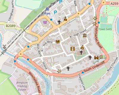
 Walk Map
©
Walk Options ( Short | Harb. )
Click on any option to show only the sections making up that route, or the heading above to show all sections.
- Main Walk (21 km)
Walk Directions
Click on any section heading to switch between detailed directions and an outline, or the heading above to switch all sections.
If you are doing the Harbour Walk, start at §I.
- Rye Station to Playden (2¼ km)
- Turn right out of the station and go up to the B2089. Cross the tracks at the level crossing and turn right onto a footpath which leads into Tillingham Avenue and continues alongside the River Tillingham. At Rolvendene Farm take the footpath heading north-west up Leasam Hill. At the top turn right onto Leasam Lane and follow it to the A268. Turn right briefly onto the road, cross over and turn left to go through Playden churchyard.
- Turn right out of the station and go along the pavement to the B2089. Cross the tracks at the level crossing and almost immediately turn right onto a signposted footpath, a tarmac path which leads into Tillingham Avenue. At the end of this residential street continue on the tree-lined path (or the grassy strip to its left) alongside the River Tillingham.
- Where the path turns away from the river keep ahead through a metal kissing gate with a footpath waymarker to continue on a low embankment. There is a house ahead on your right and you will be going up the hillside to its left, so after swerving around a small inlet fork right at a footpath marker post. Pass to the left of a wooden fieldgate and go up to a small wooden gate alongside a wire fence.
- Go through the gate to climb steadily up Leasam Hill, with increasingly fine views of the river valley (and back towards Rye). After going alongside a copse the path leads you through a wooden kissing gate. The rest of the ascent is between a tall hedge (blocking the valley view) and a fenced-off meadow.
- At the top turn right onto the tree-lined driveway to Leasam House, signposted as a footpath. This soon merges with Leasam Lane, signposted as a bridleway. Go all the way along this quiet lane, passing a communications mast and with occasional views across the undulating countryside on the left.
- At the little triangle of roads in front of the A268 veer right and cross the main road carefully onto a broad grassy strip. Just after passing a bus shelter turn left onto the gravel driveway of St Michael's church? and follow it into the churchyard.
- Playden to Scots Float Sluice (2 km)
- Leave the churchyard on the footpath heading east. Turn left to cross Butt Field, then turn right onto a track (Rectory Lane). Where this splits take the left fork. Shortly before reaching a road turn left onto the footpath going through Saltbarn Farm, then turn right at a path crossing. Turn right onto Houghton Green Lane, then turn left onto Military Road to come to the sluice gate at Scots Float.
- From the church door head E on a grassy path to leave the churchyard through a wooden gate with a footpath waymarker. At the end of the fenced path go through another gate into Butt Field?. The right of way is to go halfway along its right-hand edge and then turn left at a footpath signpost to cross the field to a gate in the middle of the other side, but there is also a well-used grassy path going directly to that exit.
- On leaving the field turn right onto a track. At the entrance to a house keep left to continue on the tree-lined track. At the end go through a wooden fieldgate with two footpath waymarkers into a field, with the view across Walland Marsh dominated by a wind farm? about 5 km away.
- Fork left onto the grassy path going diagonally down across the field. In the bottom corner go over a stile and follow the path through some trees into a meadow, with two grassy paths ahead. Once again the right of way is along the right-hand edge down to a gate where you would turn left onto another footpath across the meadow, but the well-used mown path on the left conveniently cuts off this corner.
- On the far side of the meadow follow the path out past an old stile. Ignore the sharp left turn to “Saltbarn” but at the T-junction ahead turn left onto Saltbarn Farm's driveway, uphill. At the top go straight ahead through a metal fieldgate into a field sloping down to a tree-lined stream.
- Your exit is in the bottom right-hand corner but as a notice asks walkers to stay on the footpath you should follow the grassy path ahead and then turn right in front of the stream to go along the bottom edge of the field. In the corner go over a stile and follow a grassy path along the right-hand edge of two more fields, going out through a wooden fieldgate onto a lane (Houghton Green Lane).
- Keep ahead along this quiet lane to come to a T-junction with Military Road. You need to go left along this road (with no pavement) for 200m, but fortunately you can cross over and veer left up a low embankment onto a permissive path, with the (tidal) River Rother on your right.
- As you approach the massive Scots Float Sluice? across the river you are forced back onto the road for a short stretch. On the roadside by the sluice gate there is a signpost indicating a bridleway to the right across the river, and a footpath in the oppposite direction.
- Scots Float Sluice to Gun Garden (2¾ km)
- Cross the River Rother at the sluice gate and turn right onto the Sussex Border Path (SBP). Follow this riverside path all the way back to Rye. After going under the railway line turn right onto the A259 to cross back over the river. … …
- For the shorter morning turn right to cross the river, passing a large black anchor. On the other side turn right and make your way onto the grassy path on the embankment (or the adjacent field edge if easier). You will be following three waymarked trails into Rye: the Sussex Border Path? (SBP), the Saxon Shore Way? (SSW) and the Royal Military Canal Path? (RMC).
- In 600m you go across Union Channel, a large drainage channel. On the outskirts of the town you have to nip down from the embankment in order to duck under the truss bridge carrying the Marshlink railway line, with a metal kissing gate to negotiate in a potentially muddy spot underneath the bridge.
- A final 300m along the embankment brings you to the A259 (New Road), where there is an information panel “Awaiting Attack” about the history of the Royal Military Canal. Go back across the river and cross the main road carefully as soon as possible. On the other side turn left onto a tree-lined tarmac path along the left-hand side of a recreation ground, Town Salts.
- A straightforward route is to turn right at the far end of this path onto a short street (Rock Channel East) leading back to the A259, but you could cut across the grass to that corner. Cross the main road carefully and go up a flight of steps passing one of the town's historic pubs, the Ypres Castle Inn. At the top an opening in the wall on the left leads into Gun Garden, a fine picnic spot with a view across the marshland towards the sea.
- Scots Float Sluice to Iden (2¼ km)
- Turn left onto the footpath slanting up the wooded escarpment. Follow it across fields and through Houghton Wood to a house (Old Turk) on Houghton Lane. Continue in the same direction on the footpath opposite the house to come out between houses on Grove Lane. Turn left and go along it to The Bell at Iden, on the B2082.
- For the longer morning turn left to cross the road carefully, taking the signposted footpath across a wooden footbridge in the hedge. Bear right across a small grassy area to find a narrow path going up a few steps into the undergrowth and then slanting up the steeply-wooded hillside?.
- At the top go over a stile into a large rectangular field, with a footpath waymarker pointing to the right but no clear path. Your exit from this field is on the left-hand end of the short side off to the right, 400m away. Keep to the right of a small clump of trees in the middle of the field and then head for a gap in that corner.
- Go over a stile in the field corner and follow a faint grassy path round to the left, going diagonally across a meadow to the far corner. Go over a stile into Houghton Wood and follow the path round to the right, then back to the left to cross a stream on a plank bridge. The path continues near the edge of the wood, then across the neck of a large field and to the right of a projecting hedge.
- The path comes to a wooden fieldgate leading into the corner of a field which you will be entering later, but (rather oddly) the right of way skirts around it to go along the left-hand edge of the adjacent field. In the corner go over a stile in the hedge on the left to continue in the same direction in the first field. Go along its right-hand edge and over a stile onto a lane.
- Turn right and go along the lane past a house called “Old Turk”, then turn left at a footpath signpost. Go through a wooden fieldgate and diagonally across a field to the opposite corner. Go over a stile and keep ahead past a tree-lined pond, then swerve right and left to stay near the field edge, coming to a wide gap in the hedge on the right with a three-way foopath signpost.
- The right of way is to go through the gap and turn half-left, taking the right-hand of two footpaths initially going in much the same direction. However, as there was a large patch of scrub and nettles on the direct line it is best to skirt around this to the right and then head W towards a tiny gap in the tree boundary on the far side.
- Go over a stile in this gap and continue on a faint grassy path going diagonally across a field to the far corner. Go over another stile and along a narrow fenced path between houses to a residential street (Grove Lane) in the village of Iden. Turn left and go up to its junction with the B2082. Cross the main road to come to The Bell at Iden, an early lunch stop on this option.
- Iden to Bowlers Town (1½ km)
- Go straight across the B2082 to continue on Church Lane. Turn left to go through Iden churchyard to the Recreation Ground. Turn left along its edge and continue on a footpath heading south, through fields and an orchard. Cross a track (Randolph Lane) to continue on the right-hand of two footpaths opposite to the A268 at Bowlers Town.
- To continue the walk go past the pub onto the minor road signposted to the Church and Playing Field, passing the Village Stores. In 175m, with the attractive half-timbered “Park Cottage” ahead on your right, turn left into a gravel driveway past the Old Hall. Go through a wooden gate into the churchyard of All Saints? and follow the path round to the right past the church door.
- After leaving the churchyard go straight across a driveway (leading to Iden Burial Ground) into the Recreation Ground and immediately turn left to go along its edge. Ignore a wooden fieldgate in the tree boundary ahead and take a grassy path through some undergrowth in the left-hand corner. Go out through a wooden gate and keep ahead on a grassy path through a meadow, initially with a belt of trees on your left and then down a slope.
- In the tree boundary at the bottom cross a stream on a plank bridge, go over a stile and up a bank into Randolph's Orchard?. Bear slightly right through the trees, passing a wooden bench with yellow waymarkers “Installed by the Iden Footpath Group”, to a fieldgate on the right-hand side of the orchard.
-
The right of way is to go through this gate and then bear left uphill alongside a row of lime trees, passing another exit from the orchard further along.
- At the time of writing a Natural England notice indicated that the farmer had allowed public access throughout the orchard, not just along the footpath. So you could wander through it and then return to the walk route via a rather decrepit stile in the top right-hand corner.
- Carry on through a metal fieldgate and follow a grassy path across a meadow, aiming just to the left of a hut. On the far side go across a track flanked by two stiles into a field, with waymarkers indicating two footpaths off to the left, but no clear paths. Bear slightly left to head SSE towards a large tree 125m away. Under its left-hand branches go over a stile into another field.
-
In deference to a ‘Please Keep to the Footpath’ notice you should veer right to go all the way along the right-hand field edge to the corner, then turn sharp left to go over a hump and steeply down to a small wooden gate at the bottom of the field.
- The reason for this notice is not clear. A much simpler route to this gate would be to follow the contours of the field gently downhill and round to the right.
- However you get there, go through the gate and up another field, with a wire fence on your left. At the end keep ahead at a footpath junction to go along a grassy strip past a market-garden with fields of fruit and vegetables. At the bottom go past the farm shop to the A268 in the hamlet of Bowlers Town.
- Bowlers Town to Playden (1½ km)
- Cross the road and continue on the bridleway just off to the left. In the bottom of a valley fork left onto a footpath heading south-east across fields and back uphill to the A268 at Playden.
- Turn left briefly onto the road, crossing over carefully as soon as possible. Almost immediately turn right onto a signposted bridleway. Pass to the left of a metal fieldgate to go up a short slope with a wire fence on your right. Go through a small metal gate and continue along a fenced tree-lined path down the right-hand side of a large field.
-
At the bottom go through a rusty old gate to continue along the bridleway, a potentially overgrown stretch for 100m. Where it curves right (and becomes even less appealing) fork left at an inconspicuous marker post to go up the bank into the bottom corner of a large farm field. Just off to the left you should find a clearly marked long straight path heading SE up the field.
On the horizon ahead (with a communication mast) is Leasam Lane, which you were walking along in §A and looking out over these fields.
-
Follow the path uphill to a field boundary, where it turns slightly left. On the far side of this second field go over a stile and through the tree boundary into a field sloping up to the right, where the way ahead is not so clear. The right of way is along the bottom (left-hand) edge of the field and you need to stay fairly close to it.
Ignore a tempting path slanting up the slope; this leads to a gate into the private property on the right.
- Make your way along the field below this house and then head towards the top corner at the far end, where a metal gate with a footpath waymarker leads onto a narrow fenced path between its grounds and those of another large house ahead. This rather awkward path leads out onto Leasam Lane at its junction with the A268, which you should recognise from your earlier route.
- Playden to Gun Garden (2¼ km)
- Turn left briefly onto the road, cross over and turn right into Rectory Lane. Continue on a track past Butt Field. Where this splits take the right fork. Go down to a driveway and turn right to come out onto Military Road. Turn right and go along it for 400m, then take a footpath on the left going alongside the River Rother. Cross the railway tracks and go along the side of a playing field (Cricket Salts) to the A259. Cross the main road and take the path along the left-hand side of a recreation ground (Town Salts). At the far end turn right to return to the A259. Cross the road and go up steps leading to the Ypres Castle Inn and Gun Garden.
- Unless you want to repeat your route past Playden church, cross the main road carefully and turn left onto the footway at the back of the grass verge. In 75m turn right into Rectory Lane and follow this lane past the entrance to several houses. After 250m Butt Field is on your right and you soon pass the gate from your earlier route via the churchyard. As before, go to the end of this track and into the field with a view of Walland Marsh.
- This time fork right, going through a gap in the hedge and diagonally down across the adjacent field towards a house. In the bottom corner go through a small wooden gate onto a mown path curving down to the left, merging with the house's driveway. Turn right onto a lane and follow it downhill through a wooded area, bending left at the bottom to come out onto Military Road.
- Turn right and go along its pavement for about 400m. You will be turning left off this road onto an easily-missed public footpath: at the end of a tall hedge on the left, and opposite a double garage, go through a small metal gate onto this narrow path. It soon turns right to go alongside a low brick wall on the embankment of the River Rother.
- In 150m the path comes to the end of a driveway. Go across it onto the continuation of the footpath, a tarmac path going past the garden fences of houses on Military Road. In a further 150m the path comes to the Marshlink railway line, flanked by white wooden gates. After crossing the tracks there is a gap on the right of the path leading down into the corner of a playing field, Cricket Salts.
- You could continue along the tarmac path, but it is more pleasant to go through a gap in the hedge and walk along the left-hand edge of this sports ground. At the far end cross the A259 carefully to continue on a tree-lined tarmac path along the left-hand side of another recreation ground, Town Salts.
- …
- Gun Garden to Strand Quay (up to 1½ km)
- The suggested route for this section includes a short loop around the town's streets, but you can easily switch to a direct route. The full route goes past the church, down Mermaid Street, back along The Mint and the High Street, up East Street and Market Street to return to the church. This time, leave the churchyard in its south-western corner and go down Watchbell Street to Mermaid Street. Go out to the A259 and turn right to come to the bridge over the River Tillingham at Strand Quay.
-
From the back of Gun Garden go up the slope past Ypres Tower? and into the south-eastern corner of the churchyard. Fork right and follow the path under the church's flying buttresses, passing an unusual water tower? on the right. On the north side you come to the entrance to St Mary's church?, which is well worth a visit.
If you want to cut out the circuit around Mermaid Street and the High Street, skip to [?].
-
Continue along the north side of the churchyard into West Street, passing Lamb House? at a sharp right-hand bend. Turn left into Mermaid Street, soon passing a famous pub on the right, the Mermaid Inn?. Go down to the bottom of this street.
If you want to cut out the circuit around the High Street and Watchbell Street, skip to [?].
- At the bottom turn right into The Mint. This street curves gently round to the right, passing a couple of tearooms and the Old Bell pub. Keep ahead along Rye's High Street, passing the Coterie Tea Rooms on the left and some coffee shops.
- Ignore Lion Street but turn right at the next junction into East Street, passing The Apothecary coffee shop on the corner. At the top the street turns right and becomes Market Street. Go past the Town Hall and turn left into Lion Street, passing some more coffee shops. Turn right in front of the church.
- Go along the northern side of the church and turn left to leave the churchyard in its south-western corner. Bear right into Watchbell Street, later passing the Catholic church and the Vintage Tea Rooms.
- Follow the street round to the right past a lookout with views over Rye Harbour and the front of the Hope Anchor Hotel. Continue down a pedestrian walkway (Traders Passage) which leads into a short street. At the bottom turn left into Mermaid Street.
- Go straight ahead across the jumble of roads at the bottom of Mermaid Street, passing the Mermaid Street Café. Go past the Rye Heritage Centre? and turn right onto the A259. Cross the road at the pedestrian crossing and follow it sharply round to the left at Strand Quay, crossing the River Tillingham.
- Rye Station to Strand Quay (1 km)
- Go up Station Approach and straight across Cinque Ports Street into Market Road. Turn left into the High Street, then turn right up Lion Street to the church. Turn right to …
- From the station go straight ahead up Station Approach, passing Jempson's supermarket on the right and a number of bus stops. Cross Cinque Ports Street carefully and continue up Market Road, just off to the left. At the top turn left into the town's High Street, passing the Coterie Tea Rooms on the left.
- In 100m turn right into Lion Street and go all the way up to the top, passing the Town Hall (on the left, in Market Street) and a couple of coffee shops near the top. The street ends at the entrance to St Mary's church?, which is well worth a visit. Turn right in front of the church.
- …
- …
- …
- Strand Quay to Castle Water (2¼ km)
- Take a permissive path going downstream alongside the River Tillingham, with the river on your left. In 200m the riverside path ends at a hotel and you have to continue along the A259 for a further 200m. Turn left into Harbour Road and go across Brede Sluice. Turn right onto the road leading to Castle Mill Cottages and keep ahead on a bridleway alongside the River Brede. Fork left onto a footpath across the grassland to Camber Castle and go past its left-hand side. Turn half-left to head east to the tree boundary around Castle Water.
-
The turning for Rye Harbour is 400m out of the town along the A259, but you might be able to avoid some of this road walking via an unofficial path on the right-hand bank of the River Tillingham.
- This path gave a fine view of the town but has been closed for repairs. Even when open it only went as far as the River Haven Hotel (halfway along). There was a polite notice there asking walkers not to go past the hotel building and the only alternative was to cut through a car park to return to the main road.
- If you have been able to taken the riverside route, turn left onto the main road to complete this stretch along its pavement. In 200m turn left into Harbour Road and follow it over the Brede Sluice, with the confluence of the two rivers just off to the left. On the other side turn right into the driveway to Castle Mill Cottages, prominently signposted as a Private Road and (in much smaller type) a public footpath.
- At a footpath signpost fork right through a wooden fieldgate to go past the front of these cottages. Continue on a narrow grassy path between hedges, with a blue waymarker at the end confirming that this is a right of way. Go through a metal gate and past a few trees onto open grassland alongside the River Brede, with a string of riverside properties opposite.
-
In 300m you rejoin the other right of way from the cottages, which has curved round in an arc. Go through a metal side gate and continue along this broad grassy track, with a ditch on your left. In 200m turn left onto a grassy spur across this ditch and go through a metal fieldgate onto open grassland, with the squat form of Camber Castle? straight ahead, 750m away.
- If this fieldgate is locked you could continue on the main track which swings round to the left in 200m, then in a further 200m bear left through a side gate and head towards the castle. Most walkers seem to take this slightly longer route, but both are shown on the OS map as public footpaths.
-
On the suggested route you have to aim slightly left of the castle, towards another metal fieldgate at the end of a wire fence 200m away. After going through this gate there are no more fences so you can head directly towards the castle across the grassland.
The building itself is only open at limited times, but you can peek into its interior through the metal railings across its main entrance.
-
The walk continues alongside a wire fence stretching away to the left from the far side of the castle, but you could make a longer circuit around its right-hand side if you want to see more of the building. To continue the walk go alongside this fence (on either side: there are gates at both ends) to the trees 200m away, heading E.
- Castle Water? is behind the trees, and a short path from the wooden gate ahead leads to the Halpin Hide if you want a birdwatching break. Much of this large lake is screened by trees but there are other viewpoints further along both afternoon routes.
- Castle Water to The Ridge (2 km)
- At the tree boundary turn right and follow the grassy path around Castle Water. In 600m turn left onto a shingle path past the southern end of the lake, then turn right onto a farm track. In 350m turn left onto a footpath heading south and then south-west past Camber Cottages to come to a path junction at the end of Morlais Ridge. Turn left onto a track (or the footpath just beyond it) to reach another major path junction at the end of The Ridge.
-
For the longer afternoon turn right in front of the trees (or left if returning from the hide) along the edge of the grassland, heading S. You will be going in this direction for 600m, occasionally with a view of the lake and passing a few side paths leading to the water's edge.
On the right-hand side of the path there is a stone memorial to a WW Ⅱ RAF pilot.
- The turning left off this path is not signposted: you need to look for a slightly raised shingle track, at a point where you are roughly equidistant from Camber Castle (500m behind you) and farm buildings ahead on your right. Turn left onto this track between gorse bushes, past the southern end of Castle Water to a T-junction ⑩ with a broad grassy strip.
- Turn right and follow this farm track for 350m, later curving gently to the right to head towards the farm buildings mentioned above. 300m before reaching them, at the corner of a large fenced field on your left, turn left through a small metal gate ⑨ into this field. Stay fairly close to its left-hand edge as it curves gently round to the right. In the corner there is a metal fieldgate on the left and a driveway ahead leading to Camber Cottages.
-
Ignore the fieldgate and keep ahead towards the cottages, using a small wooden side gate if necessary (it looks private but this is a right of way). At the back of a parking area go through a metal side gate to continue on a short grassy path through woodland. At the end go over a stile ⑧ with a yellow waymarker onto the end of an unsurfaced track (Morlais Ridge), with another track off to the left and footpaths off to both sides.
There is a choice of routes here, which rejoin after 450m.
-
Main route
- For a straightforward route turn left onto the broad track at this junction. This eventually goes past the south-western end of Long Pit (another flooded gravel pit) to reach a major path junction ⑦ with another unsurfaced track (The Ridge).
-
Alternative route
- For a more varied (but slightly awkward) route keep ahead very briefly on Morlais Ridge, then turn left onto a signposted footpath into the trees. This narrow path goes over a wide ditch on a wooden footbridge after 200m, followed by a stretch across an expanse of shingle to reach the same junction ⑦.
- The Ridge to Rye Harbour village (4½ km)
- Keep ahead at The Ridge, towards the sea. Turn left onto the cycle route running along the beachfront and follow it all the way to the mouth of the River Rother, then round to the left. Carry on past the new Discovery Centre into Rye Harbour village.
- Go straight ahead at this junction onto a path along the top of an embankment, ignoring the shingle tracks on both sides. Follow this path all the way to a T-junction ⑥ with a cycleway along the beachfront, with a “Shingle” information panel.
- Turn left onto this broad tarmac path (Cycle Route 2), which you will be following all the way to Rye Harbour village. In 700m you pass the Mary Stanford Lifeboat House? on your right. In 250m there is a track off to the left ⑤, then in 500m a short track leads to the Crittal Hide for birdwatching on the Ternery Pool.
-
In 400m there is a short boardwalk across the shingle to the right, opposite another track off to the left ②.
- A short out-and-back detour along this boardwalk provides a good view of the sea and (on a clear day) the Nuclear Power Stations at Dungeness, 13 km away.
- The track at ② is an alternative route (and was signposted as a diversion during construction work on the new Discovery Centre). After passing two bird hides you would keep right at path junctions ③ and ④, then turn left onto the main path to resume the directions at [?].
- The cycleway eventually swings left ① and passes a pair of WW Ⅱ blockhouses, with the popular beach resort of Camber Sands visible across the River Rother. You pass an old red-roofed fisherman's hut on the right, an elevated walkway on the left leading to the Gooders Hide, then the new Discovery Centre with its Lime Kiln Cafe, a possible mid-afternoon tea stop.
- In a further 250m the diversionary route joins from the left and you carry on towards the village, using the low embankment to the right of the cycleway. In front of the Nature Reserve's large car park (overlooked by a Martello Tower) the path turns half-right, passing the end of Harbour Road off to the left.
-
After crossing the access road for the RNLI Lifeboat Station the beer garden for the William the Conqueror pub is on your left; this is the suggested lunch stop on the Harbour Walk. Before starting the stretch back to Rye (along Harbour Road) it is worth taking in the view from the lookout by the river, at the end of a grassy embankment?.
It is tempting to set off along the embankment but you would need to turn left off it almost immediately; there is no way back to Harbour Road further on as it is blocked by the Rye Wharf industrial estate.
-
To continue the walk from the pub, go down the short street away from the river (passing the Watch House and other attractive old buildings) and turn right into the long straight Harbour Road. The Avocet Gallery (which has a seasonal tearoom) is on the left-hand side, opposite the Rye Harbour Stores.
- If you want to finish the walk here, the 313 bus stop is just beyond the Gallery at the junction with Tram Road.
- Rye Harbour village to Strand Quay (3 km)
- Follow Harbour Road out of the village. In 800m turn left onto a permissive path parallel to the road which goes all the way to Brede Sluice. Go back across the river and retrace your outward route along the A259 to Strand Quay.
-
Follow Harbour Road out of the village, passing the (closed) Inkerman Arms. After the last of the houses the entrance to Rye Wharf is on the right, flanked by two massive buoys. On the left-hand side of the road there is a small recreation ground with the unusual Church of the Holy Spirit? on the far side.
- For a small detour you could go diagonally across the ground and through its lychgate for a closer look at the church (and the lifeboat memorial at the back of the churchyard), then rejoin the road from its main entrance path.
- Beyond the church you have to endure another 450m of bleak industrial sites on Harbour Road, although the walking is easy enough on a wide combined cycleway and footway. Where the road straightens out at the end of a gentle curve to the right, turn left onto an unsignposted path ⑮ between high metal railings.
-
The route is now a rather more pleasant grassy path along the edge of the marshland. The path bends right across a wide drainage ditch and passes a “Castle Water” information panel, then comes to a Y-junction.
- At the end of the left-hand path a boardwalk leads to a large wooden viewing platform over the water's edge, but this is 150m away and there are similar views of the lake further along the main path.
- For the main route, fork right. In 250m you pass some ponds on the right, beyond which you might be able to glimpse an oil refinery? through the trees. More appealingly, a gap in the trees on the left gives a view of Castle Water.
- In 250m keep ahead where a grassy path ⑭ joins from the left, finally leaving the guided trail. Follow the path over a ditch on a footbridge and out through a wooden gate onto a broad grassy path along a shallow embankment?. At the far end the path continues through undergrowth and comes out onto Harbour Road by Brede Sluice.
- Go across the River Brede and turn right onto the A259 to retrace your outward route back to Strand Quay. As before, you might be able to switch to an unofficial riverside path after passing the River Haven Hotel.
- Strand Quay to Rye Station (¾ • ½ km)
-
 To visit one of the town's famous pubs, retrace your outward route up to the Mermaid Inn and perhaps the Ypres Castle Inn. Afterwards, take one of the roads or alleyways down to the High Street.
To complete the walk, go down Market Road and across Cinque Ports Street to the station.
To visit one of the town's famous pubs, retrace your outward route up to the Mermaid Inn and perhaps the Ypres Castle Inn. Afterwards, take one of the roads or alleyways down to the High Street.
To complete the walk, go down Market Road and across Cinque Ports Street to the station.
-
Alternatively, for a direct route to the station take the path on the right-hand bank of the River Tillingham. Cross the railway tracks and turn right onto a path leading to the B2089. Go back across the railway and turn left to reach the station.
-
Alternatively, for a direct route to the station take the path on the right-hand bank of the River Tillingham. Cross the railway tracks and turn right onto a path leading to the B2089. Go back across the railway and turn left to reach the station.
-
Main route (¾ km)
- There is a popular fish'n'chip shop and the Café on the Quay by the roundabout. For other places, retrace your outward route along the A259 and turn left by the Rye Heritage Centre to come to the Mermaid Street Café at the bottom of Mermaid Street.
-
Go up this cobbled street to the Mermaid Inn, on the left two-thirds of the way up.
- If you want to (re)visit the Ypres Castle Inn below Gun Garden, zig-zag right and left further up the street. Cut across the churchyard and go down past Ypres Tower towards the viewpoint; the pub is signposted down a flight of steps.
-
A simple way to complete the walk is to go down West Street (from the top of Mermaid Street) or Lion Street (from the church) to the High Street.
- From the Mermaid Inn, you could go down a cobbled alleyway from its courtyard and turn right at the bottom to reach the High Street.
- From the High Street go down Market Road, between West Street and Lion Street. At the bottom go straight across Cinque Ports Street and along Station Approach to the station building. A few rush-hour trains to Ashford leave from Platform 2 on the near side, but you will normally need to cross the footbridge on the right to Platform 1.
-
Direct route (½ km)
- Cross the main road at the pedestrian crossing and take the path on the right-hand bank of the River Tillingham. Immediately after crossing the railway tracks, flanked by white-painted wooden gates, turn right onto a narrow path between the railway and Rye Windmill? (now a B&B). Continue along a street past the Fire Station.
-
At the end turn right onto the B2089, cross back over the tracks at the level crossing and turn left along Station Approach to reach the station building.
…
- Castle Water to Strand Quay (3 km)
- At the tree boundary turn left and follow the perimeter path around Castle Water and onwards to the permissive path running parallel to Harbour Road. Turn left onto this path and follow it to Brede Sluice. Go back across the river and retrace your outward route along the A259 to Strand Quay.
- For the shorter afternoon turn left in front of the trees (or right if returning from the hide) along the edge of the grassland, initially heading N and curving round to the left. In 500m, at the end of the tree boundary, turn right through a wooden side gate ⑫ to head NE with a wire fence on your right, soon with views of the lake beyond it.
-
After going through the next wooden side gate the path splits. For the most direct route keep ahead on the main path, now with a wire fence on your left.
- For a closer view of the water take the right-hand path, which zig-zags near the water's edge and rejoins the main path shortly before another gate.
- Go through this gate ⑬ onto an enclosed grassy path, which soon turns abruptly left to head N. At the far end turn left at a path T-junction ⑭, leaving the guided trail. …
- …
- Strand Quay to Rye Station (¾ • ½ km)
-
For the greatest choice of tea places, retrace your outward route to the bottom of Mermaid Street. Turn left into The Mint to reach the High Street.
…
- …
-
Main route (¾ km)
- …
- Continuing up this cobbled street would bring you to the Mermaid Inn, but for the High Street turn left into The Mint. This street curves gently round to the right, passes the Swan Cottage Tea Rooms on the left and (in an alley on the right opposite the Old Bell pub) Cobbles Tearoom.
- If you are still looking for tea places there are five or six more ahead along the High Street, including the Coterie Tea Rooms on the left after passing Market Road and The Apothecary coffee shop at the junction with East Street on the right.
- … …
-
Direct route (½ km)
- …
-
…
…
- Strand Quay to Saltcote Place (1¾ km)
- Cross the main road and take the riverside path on the right-hand bank of the River Tillingham, crossing the railway tracks and later the B2089. After the path cuts across a meadow it joins a tarmac path heading north, back alongside the river. Follow it round to the right and go across Love Lane onto a footpath climbing steeply uphill to Rye Cemetery. Go through the cemetery to the A268. Cross the road and go along Saltcote Lane to the entrance to Saltcote Place.
- Cross the main road at the pedestrian crossing and take the riverside path on the right-hand bank of the River Tillingham. Follow the path across the railway tracks, past Rye Windmill? and over the B2089. The path then cuts across across a meadow and comes out at the end of Tillingham Avenue. Bear left to continue on a grassy strip beside the river (or the tree-lined path to its right), briefly repeating a short stretch of the Main Walk.
- This time, stay on the tarmac path as it turns half-right and comes to a driveway. Go across this (slightly to the left) and through a wooden gate onto a footpath climbing steeply uphill, partly on steps. Keep to the right-hand side of the grassland and go through a metal gate at the top. Keep ahead on the main path through Rye Cemetery, soon passing between two chapel buildings.
- You could continue on the tarmac driveway up the right-hand side of the cemetery, but the right of way is a more pleasant route along a grassy path ahead, then through a memorial garden on the right. Turn left onto the driveway, soon passing a “Rye Union Workhouse” information panel. Follow the drive out past a water tower to the A268, with the Kings Head Inn off to the right.
- Cross the main road carefully onto the side road (Saltcote Lane / Mill Road) opposite the pub, and fork left where it splits. In 75m Saltcote Lane passes between brick pillars, with a footpath signpost confirming that this private road is also a right of way. Follow the tree-lined avenue as it curves round to the right and comes to the imposing entrance gates to Saltcote Place?.
- Saltcote Place to Rye Station (2 km)
-
Turn left onto a footpath going down to New England Lane. Turn right onto the lane and continue on a footpath descending to Military Road.
…
…
Halfway along turn right onto a path leading back to the A259. Cross over and go up steps to East Cliff. Turn left and follow the road round to the right, where it becomes the High Street.
…
- Turn left in front of the gates onto a narrow path descending between fences, briefly heading away from Rye. At the bottom turn right onto a lane and continue on a tarmac path on its left-hand side in front of the end house. This veers left and right and goes down a slope to Military Road.
- …
- …
- …
-
In 150m turn right onto a tarmac path towards the town. Go back across the A259 and up a flight of steps to a lookout? on East Cliff. Unless you want to take a closer look at the medieval Landgate? (100m down the street to the right), turn left for the best choice of tea places.
-
East Cliff curves round to the right and becomes the town's High Street. There are five or six cafés and coffee shops in the 200m before you reach Market Road on the right, the route to the station.
- For a longer walk around the town, take one of the streets going uphill from the High Street to the area around the parish church. You could (re)visit the Ypres Castle Inn below Gun Garden, or go down Mermaid Street for the Mermaid Inn. Any street or alleyway going downhill will lead back to the High Street.
-
…
…
- St Michael, Playden dates from around 1190 and much of the Norman stonework survives. Its finest possession is an early 14thC carved oak screen.
- The Butt Field was used for archery practice in medieval times (the butt was the mound of earth behind the target).
- The Little Cheyne Court Wind Farm was developed by Npower despite objections from local environmental organisations. Its 26 turbines have been operational since 2009, with a combined capacity of 60 MW.
- Scots Float Sluice was constructed in the early 18thC to control the river level for navigation. It prevents tidal saltwalter flowing upstream and maintains the marsh environment in dry summers. It is named after Sir John Scot, who enlarged a harbour on the site in the 15thC.
- The Sussex Border Path runs for 240 km along the length of West & East Sussex, from Thorney Island on the Hampshire border to Rye.
- The Saxon Shore Way runs for over 250 km, from Gravesend on the north Kent coast round to Hastings in East Sussex. It marks a line of coastal fortifications built by the Romans in the 3rdC as a defence against Saxon invaders.
- The Royal Military Canal Path runs for 45 km, mostly alongside the canal built in the early 19thC to protect England from a threatened Napoleonic invasion.
- The ‘hillside’ alongside Military Road to the north of Scots Float Sluice would have been a sea cliff in medieval times, as implied by the route of the Saxon Shore Way.
- All Saints, Iden dates from the early 12thC, with the chancel added in the 13thC and tower in the 15thC. It contains several medieval monuments and a mid-20thC painting “Return of the Prodigal Son” by Hans Feibusch.
- Randolph's Orchard (which is Open Access) was planted in 1998 with 25 varieties of apple, plus several pear and plum trees.
- Ypres Tower was probably built in the 14thC (not 1249 as previously thought). It was part of Rye's defences against French raids but was unable to prevent much of the town being destroyed in 1377. It now houses the Rye Castle Museum.
- The Water Tower in the churchyard was constructed in 1735 for public use. Water was pumped up the hill and a plaque says that “householders [could have] water carried to their houses”.
- St Mary the Virgin, Rye dates from 1150 but suffered major damage in 1377 when its bells and other valuable items were looted to France (though later recovered). Its prominent tower has acted as a shipping beacon for centuries.
- The elegant Lamb House was built in 1723 for the town's mayor, James Lamb. It was the home of the American writer Henry James from 1898 to 1916, and was later rented by the author of the “Mapp and Lucia” novels, EF Benson.
- The Mermaid Inn is a Grade Ⅱ* listed 15thC inn with Tudor additions. It was the local base of the notorious Hawkhurst Gang of smugglers in the mid-18thC.
- The Rye Heritage Centre on Strand Quay includes a detailed model of how the town looked in 1872, constructed by two volunteers in the 1970s.
- Camber Castle has a concentric design with four circular bastions around a central keep. The fort was constructed by Henry Ⅷ in the 1540s to protect the anchorage outside Rye from French attacks, but it soon became obsolete as the harbour silted up and the coastline receded; it is now 1½ km inland.
- Castle Water was created when gravel extraction ceased in 1970. In 2003 Sussex Wildlife Trust began a major wetland creation project to create more freshwater and reedbed habitat.
- The Mary Stanford Lifeboat House has been left abandoned as a monument to the 17 crew who drowned in 1928 when their lifeboat capsized while answering a distress call, one of the worst disasters in the history of the RNLI.
- This is the trackbed of the Rye Harbour branch line, a spur from Rye station which led to a jetty in the village. It was only used for freight and closed in 1960.
- The Church of the Holy Spirit, Rye Harbour was built in gothic style in 1849. A new chancel was added in 1912; inside, the roof is in the shape of an upturned boat. There is a fine memorial in the churchyard to the victims of the Mary Stanford Lifeboat tragedy.
- The oil refinery on Harbour Road is the continuation of a local industry which developed in the late 19thC, distilling tar from gasworks into products such as creosote and paint thinners.
- The white smock Rye Windmill was rebuilt in 1932 after a fire; there has been a windmill on this site since the 16thC. The building has been a B&B since 1984.
- Saltcote Place was built as a private residence in 1905, in Queen Anne style. It has subsequently been used as a military headquarters and three times as a school, and is now a luxury guesthouse and wedding venue.
- A plaque on the East Cliff lookout records that it was donated by the writer EF Benson when mayor of Rye in 1935.
- The Landgate was built in 1329 to help protect the town from French raids. It is the only one of the town's four medieval gateways to survive.
If you are doing the Long Walk (via Iden), go to §D.
Continue the directions at §H.
This section includes a short loop around this attractive town, among other things giving you the opportunity to check out possible tea places for the end of the walk. The directions below point out a couple of places where you could cut out this loop and switch to a direct route.
Continue the directions at §J.
The suggested route starts with a short loop around this attractive town.
If you are doing the Short Walk (omitting Rye Harbour), go to §O.
The entire loop around Rye Harbour Nature Reserve essentially follows the route (in reverse) of a guided trail, waymarked with painted white numbers on posts and gates; this is point ⑪.
If you are doing the full Harbour Walk (with the Rye Hill loop), go to §Q.
The suggested route goes through the town for the opportunity to (re)visit one of its famous pubs. If you do not want to stop for refreshment the direct route in [?] is a relatively traffic-free route to the station.
The next 1½ km is along the route of a guided trail around Rye Harbour Nature Reserve, waymarked with painted white numbers on posts and gates; this is point ⑪.
If you are doing the optional extension via Rye Hill, go to §Q.
The suggested route to the station goes along the town's High Street for the greatest choice of tea places. If you do not want to stop for refreshment the direct route in [?] is a relatively traffic-free route to the station.
Walk Notes
» Last updated: April 8, 2024
Return to Top | Walk Map | Walk Options | Walk Directions.