North Downs Way : Sandling to Wye walk
Pretty Ridge Walk along the North Downs Way with lovely views. Nice pubs for lunch and tea

On the escarpment before lunch
Sandling to Wye walk
May-12 • Saturdaywalker on Flickr
swcwalks book3 walk24 banner 7157198231
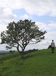
Mid morning
Sandling to Wye walk
May-12 • Saturdaywalker on Flickr
swcwalks book3 walk24 walkicon 7157197415

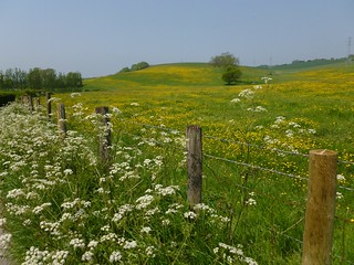
Buttercups in late May
Sandling to Wye walk
May-12 • Saturdaywalker on Flickr
swcwalks book3 walk24 walkicon 7157197959

Descending to Stowting
Sandling to Wye walk
May-12 • Saturdaywalker on Flickr
swcwalks book3 walk24 walkicon 7157198471

Mid afternoon
Sandling to Wye walk
May-12 • Saturdaywalker on Flickr
sandlingtowye24512 swcwalks book3 walk24 walkicon 7157199175
Book 3, Walk 24, Sandling to Wye
The mysterious redhead strode the Downs... 1 Sept '07
wye book3 northdownsway sandling walk24 swcwalks mapledwalk tocw324 1336979685
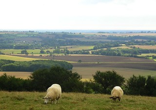
Book 3, Walk 24, Sandling to Wye
The view was certainly lovely, but the grass was fresh and green... 1 Sept '07
sheep wye book3 northdownsway sandling walk24 swcwalks mapledwalk tocw324 1337855804
| Length |
20.9 km (13.0 miles) |
|---|---|
| Toughness |
6 out of 10 |
| Maps |
OS Landranger 179 or 189 (ie, either map has the whole walk route) OS Explorer 137 and 138 (ie, you need both these maps) |
| Walk notes |
This lovely walk follows one of the finest sections of the North Downs Way (NDW) along the edge of the North Downs escarpement – in many ways it feels more like the South Downs - with fine views for nearly the whole walk. There is just one 3km (1.8 mile) section mid afternoon when you are away from the escarpment edge. While the North Downs Way is waymarked, it is not always comprehensively so, and in places the waymarks are confusing or missing. The path is not always as obvious as one might expect from such a major long distance footpath. Hence the directions in the pdf version of this walk - see the DOWNLOAD WALK button above. While they for the most part follow the North Downs Way once it has climbed from Sandling up onto the ridge, the creation of access land has also opened up some escarpment sections that were formerly off limits to walkers, and where these improve the walk they have been included in the walk directions. There is also a map-only version of the directions (see bottom of this page) for those that prefer this. While downland can be relatively dry in winter, this walk does have several sections on shady tracks that look potentially very muddy between November and March. In early spring, all the woods en route have good displays of celandines, wood anenomes and bluebells, plus some wild garlic. In late spring there can be intense displays of buttercups on this walk. |
| Walk Options |
|
| Transport |
Sandling is served by hourly direct trains from Charing Cross and London Bridge via Ashford, (journey time 1 hour 31 minutes from Charing Cross), but you can reduce that to 53 minutes by taking a Southeastern high speed train from St Pancras International to Ashford (small supplement payable and no London boundary zone tickets allowed), changing there for Sandling. Returning from Wye, there is either an hourly train to Charing Cross (two an hour in rush hours) taking 1 hour 29 minutes, or you can change at Ashford for St Pancras (1 hour 4 minutes). |
| Lunch |
The Tiger Inn (01303 862130) in Stowting, 9.3km (5.8 miles) into the walk, is a charming and friendly pub on a quiet country lane, which has a substantial dining area, as well as outside tables. Food is served 12-2.30pm Monday to Friday, 12-3pm Saturday, and 12-7pm Sunday, as well as Monday to Saturday evenings from 6pm to 9pm. The pub is open all afternoon daily for drinks. If the Tiger Inn is full, there is an alternative pub 2.2km (1.4 miles) further up the road – the Five Bells Inn (01303 813 334) in Brabourne, a charmingly quirky pub with plenty of seating both inside and out. It serves food 12-3pm Monday to Saturday and to 6pm Sunday and bank holidays, along with 5-9pm Monday to Saturday, and is open all afternoon daiy for drinks. This requires a detour off the walk, however, which adds 800 metres (0.5 miles) to the walk length. See the walk directions pdf orthe GPS file for details. For picnics, the morning part of the walk offers many fine vantage points at which to eat, but perhaps the best is the lovely hill mentioned in paragraph 38 of the directions (so long as you don’t mind eating surrounded by sheep). |
| Tea |
It is 10.8km (6.7 miles) after lunch in Stowting to Wye. There is a cafe in the village - the Wye Coffee Shop and Kitchen - but this closes too early for our purposes, at 4pm Tuesday to Friday, 3.30pm Saturday, and 3pm on Sunday and Monday. Nearby in Church Street, the Kings Head (01233 812418) is open from 4pm to 9pm Monday to Wednesday (drinks only: no food), and all afternoon and evening on other days. It serves food until 6.30pm on Sunday, but not between 4pm and 6pm Thursday to Saturday. On Sundays in spring and summer, when the Tickled Trout is doing live music in its garden (see below), it is pretty much the only tea stop./p> Otherwise the Tickled Trout pub (01233 812227) down by the river, and just across the bridge from Wye station, is an excellent place to finish the walk, with a garden by the shallow River Stour in which weary walkers can paddle their feet in summer. It serves food from 5pm onwards Monday to Saturday and all afternoon to 7pm on Sundays, and in the past has had cakes on offer as well as hot drinks. However on Sundays from April to September it hosts live music from 5.30pm in its riverside garden, and sometimes it seems to hold functions on Saturday evening too, at which times it is basically ruled out as a quiet tea or drinks stop. |
| North Downs Way |
This walk is a stage of the North Downs Way - a 125 / 131 mile national long distance path - that follows the North Downs ridge in South East England. |
|---|---|
| Profile | |
| Help Us! |
After the walk, please leave a comment, it really helps. Thanks! You can also upload photos to the SWC Group on Flickr (upload your photos) and videos to Youtube. This walk's tags are: |
| By Train |
Out (not a train station) Back (not a train station) |
| By Car |
Start CT21 4HH Map Directions Return to the start: Finish TN25 5EB Map Directions Travel to the start: |
| Amazon | |
| Help |
National Rail: 03457 48 49 50 • Traveline (bus times): 0871 200 22 33 (12p/min) • TFL (London) : 0343 222 1234 |
| Version | |
| Copyright | © Saturday Walkers Club. All Rights Reserved. No commercial use. No copying. No derivatives. Free with attribution for one time non-commercial use only. www.walkingclub.org.uk/site/license.shtml |


Walk Directions
Full directions for this walk are in a PDF file (link above) which you can print, or download on to a Kindle, tablet, or smartphone.
The directions below are just an outline for use with a map.
This is just the introduction. This walk's detailed directions are in a PDF available from wwww.walkingclub.org.uk
- [Map 1] : Older OS Maps are misleading at the start due to changes caused by the Channel Tunnel. Starting from Sandling Station car park (on the south side of the tracks), head southeast along what seems to be the route of the dismantled railway shown on the map.
- Where this disappears into a tunnel, veer left up steps and through woods (ignoring a few footpaths with a "no through path" sign on the left), then eventually turn left (north) at a T-junction to join the Elham Valley Way (About 1km in total).
- The remainder of the route is easy to follow. Continue North for 2km, following the Elham Valley Way, over the M20, and up Tolstoy Hill to the Radio Masts.
- NDW: Head North West on the well marked North Downs Way (NDW) towards Cobbs Hill (4km)
- [Map 2] : NDW: Continue on the NDW, approx 300 degrees. The NDW leaves the ridge.
- NDW: At the bottom of the hill is the small village of Stowting and the excellent Tiger Inn (lunchtime pub) (1.5 km).
- NDW: After lunch, its back up to the ridge, for a further 1.5 km
- [Map 3] : NDW: Continue north west along the NDW (4 km)
- NDW: There is a lovely viewpoint at the end of the Ridge. You can a wide sweep of the Kent coast, as far as the hills around Hastings, as well as Wye and its station.
- [Map 4] : NDW: Head North along the escarpment for 1 km, then turn west down through the woods then fields into Wye (3km).
- NDW: The Tickled Trout pub is at the far (west) side of the town, the station 100m further.