South Downs Way 8 : Southease to Eastbourne Walk
2 Long Ridge walks over open downs, beautiful Alfriston for lunch, and Eastbourne pier and seafront to finish.

Deep Dean, near Windover Hill
SWC Walk 25 - South Downs Way 8 : Southease to Eastbourne
Oct-15 • thomasgrabow on Flickr
swcwalks swcwalk25 walkicon banner 21719550523

Eastbourne Pier (II)
SWC Walk 25 - South Downs Way 8 : Southease to Eastbourne
Oct-15 • thomasgrabow on Flickr
walkicon swcwalks swcwalk25 21718057744
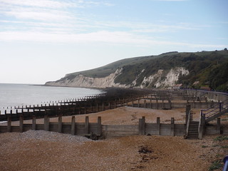
Groynes and Cliffs
SWC Walk 25 - South Downs Way 8 : Southease to Eastbourne
Oct-15 • thomasgrabow on Flickr
walkicon swcwalks swcwalk25 22340815805

Bedddingham Hill, from Windover Hill
SWC Walk 25 - South Downs Way 8 : Southease to Eastbourne
Oct-15 • thomasgrabow on Flickr
walkicon swcwalks swcwalk25 21719528573

Sheep in an orderly line
SWC Walk 25 - South Downs Way 8 : Southease to Eastbourne
Oct-15 • thomasgrabow on Flickr
walkicon swcwalks swcwalk25 22340377635
| Length | 27.3 km/17.0 mi |
|---|---|
| Toughness | 8 out of 10 |
| Maps | OS Explorer OL25 Eastbourne and Beachy Head |
| Features |
This walk along the South Downs Way (SDW) consists of spectacular ridge walks with three steep ascents and a picturesque village in the middle for lunch and another one for tea, and with Beachy Head, Eastbourne promenade, beach and pier at the finish. It's a long but very rewarding walk. The route is well waymarked, the paths are easy walking, and the route is easy to follow. The South Downs are treeless and open, so there are good views throughout (weather permitting). The walk starts at Southease Station, right on the SDW, and climbs the first ridge straight away, up to Itford Hill and then along the ridge to Firle Beacon, the highest point of the walk. There is an alternative start in Glynde in case the trains to Southease don't connect well. At the end of the ridge you descend into Alfriston, a pretty village in the scenic Cuckmere Valley, with a village green dominated by a large church. Several good pubs and tea rooms and a village shop vie for your lunch business. After lunch, follow the northern leg of the SDW up and over Windover Hill and down to Jevington (tea room [summer only] and pub) before a final climb to head south along another ridge towards the coast. There is an inland shortcut into Eastbourne if you're tired, but the suggested route is to continue along the ridge to the coast, near Beachy Head. From here, head downhill into Eastbourne to join up with the SDW's Coastal Route and follow the promenade along the beach into town towards the pier. |
| Walk Options |
|
| Transport |
Eastbourne : 2 trains an hour (1 Sunday evening), about 1 hr 30 from Victoria Glynde : 1 train an hour (change at Lewes) from Victoria, also about 1 hr 30 Southease : 1 train an hour (change at Lewes) from Victoria, also about 1 hr 30. By Car: Park at Glynde Station (free), direct train back from Eastbourne. Saturday Walkers' Club: Take the train closest to 9:15 from Victoria. |
| Lunch/Tea |
Southease: YHA tea room - closes early. Glynde: small village shop (the pub has closed). Alfriston (lunch): excellent pubs, tea rooms, village shop, large green by the church for a picnic Jevington (afternoon tea) : pub, tea room (summer only). Eastbourne (the end) : many places. |
| South Downs Way |
This walk is one of 9 stages of the South Downs Way - a 109 mile national long distance path - that traverses the South Downs National Park in South East England. |
|---|---|
| Profile | |
| Help Us! |
After the walk, please leave a comment, it really helps. Thanks! You can also upload photos to the SWC Group on Flickr (upload your photos) and videos to Youtube. This walk's tags are: |
| By Train |
Out (not a train station) Back (not a train station) |
| By Car |
Start Map Directions Return to the start: Finish Map Directions Travel to the start: |
| Map Walk | This walk requires an OS map and a compass or GPS for navigation. You can print out OS maps using the link above. |
| Amazon | |
| Help |
National Rail: 03457 48 49 50 • Traveline (bus times): 0871 200 22 33 (12p/min) • TFL (London) : 0343 222 1234 |
| Version |
Oct-19 Andrew |
| Copyright | © Saturday Walkers Club. All Rights Reserved. No commercial use. No copying. No derivatives. Free with attribution for one time non-commercial use only. www.walkingclub.org.uk/site/license.shtml |


Walk Directions
- Start at Southease Station
- SDW: Head east - cross the road (using the bridge), and climb Itford Hill.
- SDW: Follow the ridge past the radio station on Beddingham Hill to Firle Beacon, the highest point of the walk.
- Start at Glynde Station
- Head south along the small road, cross the busy A27 (there's a median), and continue south up the car wide track.
- SDW: On the ridge, head east along the SDW towards Firle Beacon
- SDW: Follow the waymarked path along the ridge over Bostal Hill and past Long Burgh Long Barrow, before descending into Alfriston village.
- There are pubs, a tea room, and a village shop in the village. Visit the church on its picturesque green.
- SDW: Cross the Cuckmere River, and tackle the northerly SDW route up to Windover Hill (there is a shortcut route through a field on the initial part of the ascent)
- SDW: Take one of three paths over or around the summit of Windover Hill.
- Apart from the direct route over it, there is also the car wide southerly track (a bridleway) curving around the summit, and a northerly footpath passing along the fence at the top of The Long Man of Wilmington (a chalk figure, side-on views only!).
- SDW: Follow the SDW down into Jevington (tea room and pub)
- SDW: Head a few metres south along the lane, and climb back up to Bourne Hill along a shaded track
- SDW: Turn south along the ridge, with views of Eastbourne and the sea
- Cross the A259 and in another 400 metres a left forking signposted bridleway is a shortcut to the station (at GR TV 5878 9824). [Map required once in Eastbourne.]
- Stay on the ridge, immediately passing a trig point and a dew pond on the left, cross the B2103 and in another 700 metres, by a signpost on the right (at GR TV 5940 9691), turn down left with the SDW off the ridge towards town.
- Near the bottom of the drop you meet up with the southerly (coastal) branch of the SDW, and head east through Eastbourne, initially along a busy road.
- After 330m of road walking, fork down to the right along a tarmac path (Holywell Drive, signed for 'Holywell Promenade') above the Italian Gardens to the seafront.
- Follow the seafront promenade towards the pier
- Pass the Wish Tower (a Martello Tower).
- For a direct route to the station, turn left along Devonshire Place (by a large bandstand, i.e. before the pier)
- Continue to the pier.
- For the station, from the pier's road junction, go inland on Elms Avenue, then Elms Road. At the end, turn left along the A259, then right along the (mostly) pedestrianised shopping street (Terminus Road) all the way to the station.