Sandy to Arlesey walk
The Lodge Nature Reserve, Biggleswade Common and Jordans Mill on the River Ivel
| Length |
Main Walk: 17¾ km (11.0 miles). Three hours 55 minutes walking time. For the whole excursion including trains, sights and meals, allow at least 8 hours. Longer Walk, via Biggleswade & Broom East: 20 km (12.4 miles). Four hours 30 minutes walking time. Short Walk 1, looping back to Biggleswade: 14 km (8.7 miles). Three hours 5 minutes walking time. Short Walk 2, starting from Biggleswade: 11¼ km (7.0 miles). Two hours 20 minutes walking time. |
|---|---|
| OS Maps |
Explorers 208 & 193. Sandy, map reference TL180485, is in Bedfordshire, 6 km E of Bedford. |
| Toughness |
2 out of 10 (3 for the Longer Walk, 1 for Short Walk 2). |
| Features |
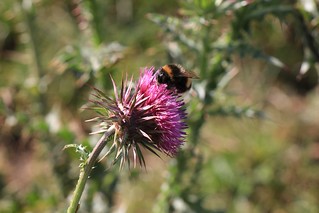
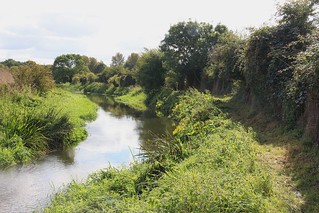
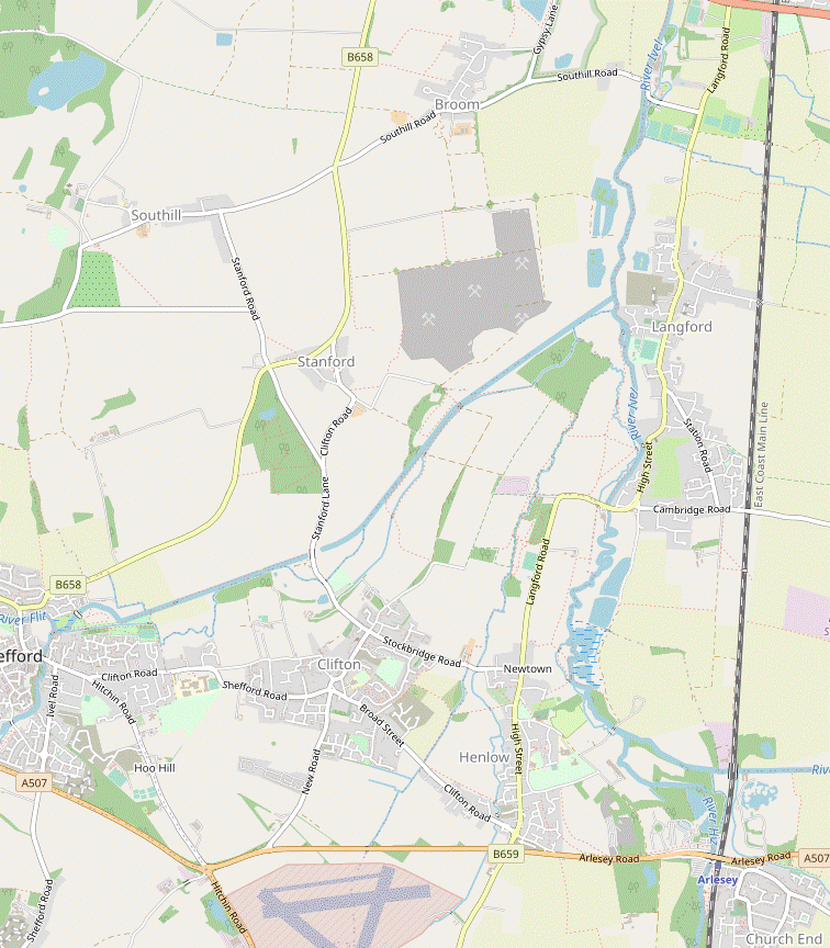
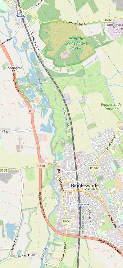
A throwaway remark in the original version of the Biggleswade to Sandy walk (#264) that there were “some attractive short riverside walks…around Biggleswade” sparked the creation of this walk, which partly follows a section of the Kingfisher Way (KW) alongside the River Ivel, a tributary of the Great Ouse. The walk starts with a forgettable ten minutes alongside a main road but then climbs a low wooded hill which was once an Iron Age hill fort and is now the site of The Lodge, the UK headquarters of the Royal Society for the Protection of Birds (RSPB). The surrounding area is an unexpected oasis of heathland, acid grassland and woodland which is managed as a nature reserve (free entry). The walk takes a longer and more convoluted route through it than the optional extension to Walk #264, taking in parts of all three of the RSPB's nature trails. The route continues across Biggleswade Common and makes its way to the riverbank, where it joins the KW for the remainder of the morning section. The suggested lunch stop is at Jordans Mill, a “food heritage attraction situated on the banks of the River Ivel”. Visitors can freely wander around its attractive garden of cereals, fruit and vegetables as well as ornamental flowers; the only charge is for tours of the Victorian mill building. For the first part of the afternoon section the route takes advantage of a new permissive path alongside the river to avoid the KW's road route through Langford, and later another detour avoids a rather featureless stretch on a rough track. Towards the end of the walk you pass Henlow Grange, now one of the Champneys chain of health spas for the rich and famous. A short loop alongside the River Hiz – which you might recognise as the ‘preamble’ to the Arlesey to Letchworth Garden City walk (#233) – brings you to Arlesey station. |
| Walk Options |
Sadly there are no riverside pubs on this walk but those wanting something stronger for lunch can opt for the Longer Walk, which makes a short out-and-back detour into the market town of Biggleswade for a choice of refreshment places. This variation then makes an extended loop out to the nearby Broom East Wildlife Conservation Site before rejoining the Main Walk at Jordans Mill. This extended loop and the intermediate station at Biggleswade enable two Short Walks. The first finishes there by looping back around Broom East from Jordans; this also provides an alternative ending if you find that the permissive path to Langford is closed. The second simply joins the Longer Walk at Biggleswade for a possible afternoon walk. |
| Transport |
Sandy, Biggleswade and Arlesey are adjacent stations on the East Coast Main Line. On weekdays there is a half-hourly cross-London Thameslink service via East Croydon, London Bridge and St Pancras; on Sundays there is an hourly service from Kings Cross. The journey time to Sandy is about 50 minutes from central London. Unless you are doing Short Walk 2 from Biggleswade, buy a return to Sandy. If you wanted to abandon the walk in the afternoon there is a bus service (Mon–Sat) along Langford Road, to Biggleswade in one direction and Hitchin in the other. If driving, the station car parks all cost around £4 after 10am weekdays, £3 weekends (2024). |
| Suggested Train |
Take the train nearest to 10:15 from St Pancras or Kings Cross to Sandy. |
| Train Times |
|
| Timetables |
|
| River Levels |
|
| Lunch |
Except on Mondays when the site is closed, the suggested place to stop for lunch (after 10¼ km) is Jordans Mill, if only because its website proclaims “we love refuelling cyclists and walkers”. Its large Riverside Café (01767-603940) has plenty of indoor and outdoor seating and serves a range of light lunches (burgers, quiches, baguettes, etc). As noted above, the Longer Walk makes a short detour into Biggleswade. There are many possible eateries scattered around its High Street and Market Square (after around 9 km), but none have been tried. Some of the town's pubs are clearly drinks-oriented, but two serving food are a JD Wetherspoon's on the High Street, the Crown Hotel (01767-310510); and the White Hart (01767-314219) at the far end of Market Square. Two other possibilities on opposite sides of Market Square are Rosso Lounge (01767-600575), a café / bar; and Surfin Cafe (01767-220581). There are many areas alongside the River Ivel suitable for picnics: eg. Biggleswade Common, Fairfield, Ivel Mill and outside Jordans Mill (but note that picnics are not permitted within this site). |
| Tea |
If you stopped for a pub lunch in Biggleswade you could have a mid-afternoon stop at Jordans Mill (see above), or just beyond Langford at a bistro café in Cherry Lane Garden Centre, The Watering Can (01462-700292; open to 5pm Mon–Sat, 4pm Sun). The only refreshment place near the end of the main walk options is a traditional pub with a garden 150m beyond Arlesey station, The Old Oak (01462-612536; open from noon Sat–Sun, 2pm Fri, 4pm Mon-Thu). On Short Walk 1 the tea options in Biggleswade are essentially the same as the lunch options listed above, with Surfin Cafe (open to 6pm Mon–Fri, 5.30pm Sat, 5pm Sun & BH) the suggested place. |
| Profile | |
|---|---|
| Help Us! |
After the walk, please leave a comment, it really helps. Thanks! You can also upload photos to the SWC Group on Flickr (upload your photos) and videos to Youtube. This walk's tags are: |
| By Train |
Out (not a train station) Back (not a train station) |
| By Car |
Start SG19 1AW Map Directions Return to the start: Finish SG15 6XA Map Directions Travel to the start: |
| Amazon | |
| Help |
National Rail: 03457 48 49 50 • Traveline (bus times): 0871 200 22 33 (12p/min) • TFL (London) : 0343 222 1234 |
| Version |
Apr-24 Sean |
| Copyright | © Saturday Walkers Club. All Rights Reserved. No commercial use. No copying. No derivatives. Free with attribution for one time non-commercial use only. www.walkingclub.org.uk/site/license.shtml |


Walk Directions
Click the heading below to show/hide the walk route for the selected option(s).


 Walk Maps
©
Walk Options
Click on any option to show only the sections making up that route, or the heading above to show all sections.
- Main Walk (17¾ km)
Walk Directions
Click on any section heading to switch between detailed directions and an outline, or the heading above to switch all sections.
If you are doing Short Walk 2 (from Biggleswade), start at [?] in §F.
- Sandy Station to The Lodge (southern exit) (4½ km)
-
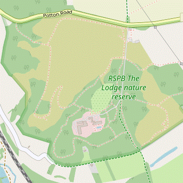 Turn right out of the station and go up to the junction with the B1042. Turn right to cross the railway and continue along the main road. In 600m turn right through a pedestrian entrance into The Lodge nature reserve. For the full route, turn right at the first path junction and follow the Buzzard trail on a zig-zag route around Galley Hill and back along a valley. Turn right onto a short link path and turn right again to follow the Nuthatch trail around the Old Quarry to the back of the main buildings. Turn left onto a path leading up to the garden, then briefly rejoin the Nuthatch trail (in the opposite direction) by the meadow. Turn right to follow the Woodpecker trail in a loop around Old Heath to the southern exit from the reserve.
-
For a shorter route you can either omit the main part of the Nuthatch trail by going directly to the meadow in front of the main building, or cut out the whole of the Woodpecker trail by going directly to the southern exit.
-
For a shorter route you can either omit the main part of the Nuthatch trail by going directly to the meadow in front of the main building, or cut out the whole of the Woodpecker trail by going directly to the southern exit.
- Arriving on Platform 2 – which has an information panel about Captain Sir William Peel? – go out of the station and turn right. Go up Station Road and turn right at the mini-roundabout to cross the railway on the road bridge (the B1042, which becomes Potton Road). Ignore minor roads off to both sides and walk along the wide pavement of the main road for 600m, passing the town's cemetery.
-
Just before reaching some chevrons at a left-hand bend, turn right through a pedestrian entrance into The Lodge Nature Reserve. Follow the track round to the left, climbing steadily through pine woods. In 300m you come to a path junction.
- A more straightforward route through the reserve (via the RSPB shop, café and a public bridleway) is described in §H of Walk #264.
- For the suggested route fork right at the junction, signposted as the Buzzard trail. This swings right and becomes a fenced path heading S, with views across the new heathland being created on the left.
-
In 500m you come to an information panel about the hill fort? on Galley Hill and the path veers left to continue just inside its low rampart. At the next corner follow the path round to the left, now heading N.
You can see the continuation of the trail in the valley down to the right.
- In 250m the path swings right and doubles back to go along the valley floor. At the bottom it curves round to the left into a more wooded area, passing some small ponds on the right. In a further 75m it comes to a junction where you turn right off the Buzzard trail onto a short link path to the Nuthatch trail.
-
Short Cut 1 (−1 km)
- To cut out the loop around the Old Quarry and the Gardens, turn left at the next T-junction. Follow the path up steps and across a meadow in front of The Lodge building. The path passes a couple of paths signposted to the Gardens, after which you can resume the directions at [?].
- For the full route turn right at the next T-junction and follow the undulating Nuthatch trail as it winds its way around the wooded slopes of a low hill, avoiding paths off to the left into an Old Quarry. The path levels off near the foot of the hill and heads S, passing the stone pillars of a disused entrance off to the right.
- The trail then climbs again and swings left, with some far-reaching views through gaps in the trees on the right. It turns left again to head N for 100m, then drops down a flight of steps on the right. In 75m turn left off the Nuthatch trail at a path junction, signposted to the Gardens.
- Go up some steps and through a wooden gate at the top into the Lodge Gardens, at the back of the administration buildings. You will be leaving them through another gate 150m off to the right, but the gardens are worth exploring; eg. a short detour to the left would reveal a “Heritage Trees” information panel by a ‘national champion’ Strawberry Tree (Arbutus unedo).
- A straightforward route would be to bear right past a few clumps of trees and shrubs to reach the Fountain Pond in the more formal part of the gardens behind the main building, where there is a paved path running alongside a balustrade. Leave the gardens through a wooden gate at the end of this path to come to a path junction by a large sweet chestnut tree.
-
Short Cut 2 (−¾ km)
- To cut out the loop around Old Heath, turn right and go through another gate. Follow the path down steps and turn left at a path T-junction to rejoin the Nuthatch trail. Fork right at the next two path junctions to join the public bridleway heading out of the reserve and go to §B.
- For the full route keep ahead at the path junction. The path curves round to the left and passes a large owl sculpture with memorial plaques off to the left, the Tree of Life. It then crosses the driveway to The Lodge and comes to a path T-junction in front of a meadow, where you turn right onto the Nuthatch trail (in the opposite direction).
- In 50m you pass a small grassy area on the left, with a viewpoint across a small pond to the meadow. In a further 50m turn right at a path junction, signposted to the Woodpecker trail. Go back across the driveway and take the path opposite.
- The path turns left, descends a flight of steps and swings right, soon passing the small Jack's Pond on the right. In 200m keep right at a path junction, joining the Woodpecker trail around Old Heath.
-
Follow the trail for 450m as it curves gradually round to the right through the heathland, passing Plantation Pond along the way. The path eventually merges with the main public bridleway running through the grounds and you follow it out of the reserve between stone pillars.
- The Lodge to Fairfield (3 km)
- Keep ahead on the bridleway to reach Biggleswade Common. Turn right after 250m and follow a path heading west and then south-west, going under the railway line. Turn left in front of the River Ivel and head south along the edge of the grassland. Go out past Fairfield Sports Ground into a small recreation area.
-
Outside the reserve keep ahead on a broad track, ignoring another bridleway off to the right alongside the boundary wall. In 100m bear right onto a path through a patch of woodland, where a small hump takes you over the barely-perceptible route of a disused railway?. On leaving the wood the bridleway crosses a stream on a bridge and you emerge onto the open space of Biggleswade Common.
- A different route through the common (via Furzenhall Farm) is described in §I of Walk #264.
- Go straight ahead on a broad mown path, heading S towards some buildings 500m away. Halfway across, however, turn right at a path crossing in the middle of the common to head W on another mown path. In 200m go through a metal kissing gate to continue with a boundary fence off to your left. The path later bends left to go alongside it, heading SW towards the East Coast Main Line.
- On reaching the railway go through a gate to pass under the tracks. On the other side keep ahead on a faint grassy path, still heading SW. In 200m cross a stream on a wooden footbridge onto another part of the common. The River Ivel is 150m away, behind the clumps of trees ahead.
-
Take any convenient path towards it and turn left on reaching the riverbank to head S, joining the Kingfisher Way? (KW). The simplest route is to stay near the edge of the open grassland, going through gates as necessary and with the river never far away on your right.
- In several clumps of trees there are small metal gates at each end of a narrow path which stays closer to the meandering river; if any of these paths do not look too overgrown you could detour onto them.
- In around 500m the Walk #264 route rejoins from a mown path on the left. Continue along the attractive riverside path for a further 700m, crossing a side stream on a long wooden footbridge along the way. At the southern end of Biggleswade Common go through a metal kissing gate to continue along the right-hand side of a narrow strip of grassland between Fairfield Sports Ground and the river.
- In 100m go through a gate into the small Fairfield recreation area, where there are a few benches and picnic tables by the riverside path. There is a boulder on the left with a plaque for the KW, and an iron sculpture at the far end commemorating the Ivel Agricultural Motor?.
- Fairfield to Jordans Mill (2¾ km)
- Cross the river on the road bridge ahead to continue on the riverside path on the other bank. At Ivel Mill the suggested route is to take a new cycle / walkway to the right of the riverside path, although this can still be used with care. The two alternative routes run parallel and rejoin at Southill Road, by the entrance to Jordans Mill.
- Follow the riverside path up to the A6001 (Shortmead Street). Turn right and cross this main road carefully, with a view of the redundant Meccano Bridge? alongside the road bridge. After crossing the river turn left by a ‘Welcome to Biggleswade · Twinned with Erlensee’ road sign. Go down a short slope and through a metal kissing gate onto the continuation of the riverside path.
- You now simply follow the path for 900m to the next bridge across the river. Along the way fork right where the path splits, bypassing a short section of the original path which has deteriorated. Eventually you go past a cluster of park homes behind a wooden fence and come to a broad track (Mill Lane), with the converted Ivel Mill? ahead on your left.
-
Cycle / Walkway
- Turn right briefly onto the track. After passing the children's playground turn left onto the all-weather cycle / walkway, signposted to Jordans Mill. In 500m it merges with the other path to go under the road bridge carrying the A1.
- On the other side the two paths split again, with the same choice. Unless you decide to switch routes fork right to return to the all-weather path, with a tall hedge separating the two paths for this long stretch. Eventually the path swings round to the right to go up to the road, but it is quicker to veer left and rejoin the riverside path for the last few steps.
-
Riverside path
- Go straight across the track onto the continuation of the riverside path. For the next 250m it runs between the river and a children's playground as a broad grassy path, but subsequently it narrows and can become more awkward. In a further 250m it merges with the other path to go under the road bridge carrying the A1.
- On the other side you have a better view of the condition of the riverside path for the long stretch ahead. Unless you decide to switch routes continue along it, with a tall hedge separating the two paths. Eventually the path goes up a short slope and comes out onto a road.
-
Turn left briefly onto Southill Road. After crossing the river on the narrow road bridge
bear left into the Jordans Mill site. The Riverside Café is in the Visitor Centre ahead, but the suggested route is to go past its right-hand side to come to an information panel in front of the mill pond. The outdoor seating area for the café is on your left, while continuing past the imposing Holme Mills? leads directly to the Mill Gardens.
- Explore the site as you wish before continuing the walk, using the map on the panel as a guide (but note that picnics are not permitted). It is well worth browsing the information panels about the varied displays in the gardens; the small wildflower meadow and patch of woodland across the mill pond are also worth a look.
- Jordans Mill to Biggleswade Station (3¾ km)
-
 From the mill site head west on Southill Road for 400m, then veer right into the Broom East Wildlife Conservation Site. Follow the perimeter path around three sides to its north-eastern corner (or take an unofficial path along its eastern boundary). Leave the site and turn right onto a bridleway. Take a short footpath diversion on the right to get under the A1 safely, then rejoin the bridleway and follow it to Ivel Mill. Continue along Mill Lane and Hitchin Street to the refreshment places in Market Square. At the far end turn right into Station Road to reach the station.
-
For the Short Walk (looping back to Biggleswade) leave the mill site and turn right onto Southill Road, taking care as there is no pavement. Go back across the River Ivel and then a backwater on another narrow bridge. You have to walk along a narrow grass verge for 400m before you come to a metal fieldgate on the right. Go through a side gate on its left into the south-eastern corner of the Broom East Wildlife Conservation Site?.
At the time of writing there was no information panel or permissive path sign at this entrance, but the perimeter path is clearly shown on the site map. A metal pole half-hidden in the roadside hedge suggests that there might be a missing ‘public footpath’ sign.
-
Direct route (−½ km)
- On entering the conservation area turn sharp right at a path junction to double back through a small gap in the hedge. Turn left and follow a faint path alongside a large arable field, heading roughly N for over 1 km. Leave the site in its north-eastern corner and resume the directions at [?].
-
For the suggested route follow the main perimeter path along the site's southern boundary for 300m, parallel to Southill Road and heading W. Keep right when you reach the site's south-western corner, ignoring a path out to a road junction. Follow the main path along its western boundary for over 1 km, with Gypsy Lane behind the hedge on your left.
Along the way you pass a viewing point over the lake in the southern part of the site, but for most of the time the water is shielded by plantations of young trees. If you are feeling adventurous you could investigate some side paths closer to the water's edge.
- At the site's north-western corner there is an information panel about the area's biodiversity. Fork right to stay on the main path, again avoiding a path out to the road. After passing another information panel the path swings left and right to skirt around a pond, then merges with the other end of the path along its eastern boundary by the exit.
- Leave the site and turn right onto a grassy track. In 30m it crosses a ditch and you fork right, temporarily leaving this bridleway for a safer route across the main road ahead. Go along a stony path for 100m, then veer left to pass under the A1 through one of several flood tunnels. On the other side the path turns left and runs parallel to the road for 150m, then swings right to continue between high hedges.
- At the end of this enclosed stretch bear right to continue between farm fields on the bridleway, heading E. In 250m cross over your outward route, passing the children's playground on the right. Keep ahead to recross the River Ivel, passing the converted Ivel Mill? on your right. Follow the lane up to a road junction.
-
For the suggested route to the station via Market Square, cross the road onto the continuation of Mill Lane, passing the Whistle and Flute pub on the right. At the T-junction with Hitchin Street the Pembroke Arms is just off to the right, but for Market Square turn left.
- Ignore a narrow street on the right after 50m, but in another 50m turn right into Market Square. The town's High Street is just 50m away to the left, and you will be able to see the Crown Hotel? through a wide gap in the buildings.
- Continuing along Market Square, Rosso Lounge is on the right and Surfin Café is the last place on the left. The White Hart pub is at the far end, on the other side of Station Road.
-
To complete the walk go down Station Road for 200m (away from the High Street). The station is off to the left of this road, with access to all the platforms from a gap at the left-hand end of the station building. Trains to London normally leave from Platform 1, on the far side of the footbridge over the tracks.
- Fairfield to Biggleswade (Market Square) (1½ km)
-
…
Recross the river at Ivel Mill and go along Mill Lane and the B659 to the High Street. Turn right and follow the High Street to Station Road, then double back along Market Square to pass a number of refreshment places.
- …
-
…
turn left onto a broad track (Mill Lane), passing the converted Ivel Mill? on your right as you recross the river.
There is a patch of grassland by the mill pool with a few picnic benches. The route described below is a short loop around the High Street and Market Square which passes many possible refreshment places (only a few of which are listed here), returning to this point to continue the walk.
- Go up to a road junction and turn left onto the B659 (St Andrew's Street). Turn right at a mini-roundabout onto the High Street, passing some cafés and the Crown Hotel?. At the next mini-roundabout turn right into Station Road.
- The White Hart pub is at the junction with Market Square, the broad semi-pedestrianised precinct parallel to the High Street. The return route starts by doubling back along it, where you pass Surfin Café on the right and Rosso Lounge on the left.
- Biggleswade Station • Market Square to Jordans Mill (3¾ • 3½ km)
-
- If starting the walk here, leave the station and turn right onto Station Road. In 200m turn left into Market Square.
-
Starting from Biggleswade Station (+¼ km)
- If starting the walk here, go up steps from the island platform to the footbridge and turn left. Outside the station bear slightly left, go down to a road junction and turn right to go along Station Road for 200m.
- With the White Hart pub on your right, turn left into Market Square to continue along this semi-pedestrianised precinct, passing Surfin Café on the right and Rosso Lounge on the left.
- At the end of Market Square turn left into Hitchin Street. In 100m turn right into Mill Lane, passing the Whistle and Flute pub on the left. Cross the B659 carefully onto the continuation of Mill Lane, retracing your steps if you started from Sandy. Cross the River Ivel, passing the converted Ivel Mill? on your left.
- Ignore paths off to both sides to continue on a public bridleway between farm fields, heading W. About 100m before reaching the A1 veer left onto a narrow path between high hedges, the continuation of the bridleway. The path gradually approaches the main road and continues alongside it for 150m before swinging right, allowing you to pass under it through one of several flood tunnels.
- On the other side turn half-right onto a stony path. In 100m it crosses a ditch and turns left onto a grassy track, briefly rejoining the original bridleway. In just 30m turn left onto a signposted permissive footpath into the north-eastern corner of the Broom East Wildlife Conservation Site?.
-
Direct route (−½ km)
- On entering the conservation area fork left at a path junction to follow a faint path alongside a large arable field, heading roughly S for over 1 km. Leave the site in its south-eastern corner and resume the directions at [?].
-
For the suggested route fork right onto the main perimeter path, passing a pond on the left and coming to an information panel about the restoration project. Keep left at the site's north-western corner, ignoring a path back to the bridleway and passing a second information panel about the area's biodiversity. Follow the main path along its western boundary for over 1 km, with Gypsy Lane behind the hedge on your right.
…
- Follow the perimeter path round to the left when you reach the south-western corner, ignoring a path out to a road junction. After continuing near its southern boundary for 300m, and just before reaching a gap in the hedge ahead (the other end of the path along its eastern boundary), fork right towards the exit.
- Leave through a side gate and turn left onto Southill Road, taking care as there is no pavement. You have to walk along its narrow grass verge for 400m, at the end crossing two narrow bridges.
- After crossing the River Ivel on the second bridge …
- Jordans Mill to Langford Mill (2 • 2¼ km)
-
Leave the mill site and turn left onto Southill Road. After crossing the river turn right onto a new permissive path and follow it all the way to Langford Mill.
- If permission has been withdrawn continue along Southill Road and turn right onto the B659. Follow it all the way into Langford and turn right onto Mill Lane to reach the mill.
- Leave the mill site by the same entrance and turn left onto Southill Road, parallel to the River Ivel in a channel on your right. Follow the road round a left-hand bend and over a bridge carrying the millstream (with a nice view of the mill, framed by trees). On the other side of the bridge there is the start of a new permissive path on the right.
-
Main route (2 km)
- Simply follow the narrow path all the way along the riverbank. Towards the end of this section you go past a number of riverside properties with warning notices about respecting their owners' privacy. Eventually you go through a wooden gate and come out onto the end of Mill Lane, with the old mill pool on your right.
-
Road route (2¼ km)
-
After crossing the millstream take the path on the left-hand side of Southill Road, which continues on the other side of Jordan's overflow car park.
- For this option you could also take a path from Jordans Meadow directly to the overflow car park, then onto the roadside path.
- You will be turning right at the T-junction ahead and it is safer to cross Southill Road at the designated cycle crossing, about 40m before reaching it. At the junction turn right onto the pavement of the B659 (Langford Road), which you now have to walk along for 1½ km.
-
Towards the end of this long stretch you pass Langford's Village Stores and The Plough pub on the left, and 250m later St Andrew's church on the right. Immediately after passing the churchyard turn right into Mill Lane.
- If you detour through the churchyard to visit the church (which is usually open) you would have to double back to the main road; there is no side exit onto Mill Lane.
- In 200m you pass Mill Meadow on the right and the road turns slightly left towards the converted mill buildings. As you reach the old mill pool there is a “Private Property” sign on a wooden gate on the right, with a less-conspicuous notice revealing that it is actually the other end of the new permissive path.
- Langford Mill to Henlow Bridge Lakes (4 km)
- Take the path between the River Ivel and Henlow Common all the way to Langford Road, coming out opposite Cherry Hills Garden Centre. Turn right briefly onto the road, then turn left onto a footpath along the left-hand edge of two large fields. Bear left through Henlow Millennium Meadow, cross the River Ivel and go past a fishing lake. Turn right onto a bridleway, then right again to recross the river. Turn left onto a footpath going past Henlow Grange (Champneys) to the north-western corner of the Henlow Bridge Lakes campsite.
- Go onto the gravel driveway curving round to the right in front of Langford Mill?, which is a right of way. Cross the River Ivel on a wide bridge and veer left through a gate onto a grassy track between hedges. Go through another gate and keep ahead on a low embankment alongside the river, avoiding a path here (and another one further along) into the water meadow on your right, Henlow Common?.
- You now simply follow this riverside path, going through a few gates along the way. In 800m go past a footbridge over the river to continue on the riverside path, ignoring another footpath towards the meadow. You pass an information panel about Seal Bank and in 500m the path comes out onto Langford Road by Boot Bridge, with Cherry Hill Garden Centre opposite.
- Cross the road carefully and turn right, passing the entrance to the garden centre (which you could detour into to visit its bistro café, The Watering Can). Just past the road sign for Henlow, turn left onto a signposted footpath. Cross a ditch and go around two sides of a large field to the opposite corner.
- Go through a gap and follow the footpath round to the left to continue along the left-hand edge of an even larger farm field. In the next corner follow the path briefly round to the right, then immediately veer left through a gap in the hedge onto a grassy path heading towards a footbridge 60m away. Go over this into Henlow Millennium Meadow?, passing a wooden owl and otter sculpture on your left.
- Unless you want to explore this small meadow, keep ahead across the grass to return to the River Ivel and bear right to walk alongside it for 100m. Cross the river on a wooden footbridge and follow the enclosed footpath as it makes its way through a wooded area, with glimpses of Poppy Hill Lakes (a fishery) through the trees on your left.
- At the end of the path bear right onto a bridleway, a rough track running beside a farm field. This comes to a T-junction where you turn right. Follow the track back across the River Ivel, past an isolated house and up to another path T-junction in front of some school grounds.
- Turn left at the junction, heading SE. In 150m you pass the first of two large notices informing you that you will be passing Champneys, the fashionable health spa in the elegant mansion soon visible off to your left, Henlow Grange?.
- Unless you have pre-booked a pampering session, go past the driveway leading to its main entrance to continue on the footpath for a further 250m, going through a couple of side gates along the way. After the second gate you are at the north-western corner of a large campsite (well shielded by tall hedges), with another waymarked footpath through a wooden side gate on the left.
- Henlow Bridge Lakes to Arlesey Station (1½ • 1 km)
-
 For the suggested route turn left onto the footpath skirting around the northern boundary of the campsite. Go under the A507 and turn left for the station, with The Old Oak pub 150m further on along Station Road.
-
For a shorter route keep ahead along the campsite's western boundary, then turn left onto a footpath along its southern boundary.
-
For a shorter route keep ahead along the campsite's western boundary, then turn left onto a footpath along its southern boundary.
-
Main route (1½ km)
- Turn left and go through the side gate onto a broad grassy strip, heading E. After a few twists and turns you are briefly heading away from the station, alongside Jordans Lake.
- The perimeter path goes around the large fishing lake and returns along its other side, with a river and then the East Coast Main Line on your left. Just before leaving the site the direct route joins from a path on the right.
-
Shorter route (1 km)
- Keep ahead on the tree-lined avenue. As you approach a main road ignore an entrance into the campsite on the left, but shortly afterwards turn left through a wooden gate onto a waymarked footpath between hedges, parallel to the road.
- Go straight across two more vehicle entrances into the site, then over a stream on a wooden footbridge. At the end of this long straight path you come to a T-junction with the main route and turn right.
- Go through a side gate by a weir onto a road and pass under the elevated A507. Turn left in front of the large station car park and cross the River Hiz? on a brick road bridge. As you approach the station there is an information panel about the Hicca Way off to your right, by the entrance to Glebe Meadows (the start of the Walk #233 route).
-
A short ramp leads onto the northbound platform, so for trains to London you have to cross the station footbridge to Platform 1. The only convenient place for refreshment before the journey home is The Old Oak; from the exit by the small ticket office you can see its pub sign at the far end of Old Oak Close, 150m away.
The Vicar's Inn (200m beyond The Old Oak on Church Lane, opposite St Peter's church) is permanently closed.
- Captain Sir William Peel was the third son of the Prime Minister Sir Robert Peel. He was a naval captain and recipient of the Victoria Cross for gallantry in the Crimean War. From 1851 he lived at Swiss Cottage on Potton Road and the panel at Sandy station was erected to commemorate the 150th anniversary of his death in 1858, aged just 33. There is a marble statue of him in the parish church, with copies in Greenwich and Calcutta.
- The hill fort on Galley Hill is believed to have been built in the early Iron Age (c.500 BC), probably as a defensive structure. There are two other (less well-preserved) hill forts nearby: Sandy Lodge (by the mansion) and Caesar's Camp (across the B1042).
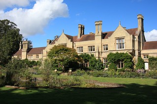
- The Lodge was built in 1870 by Arthur Wellesley Peel, the younger brother of Sir William and Speaker of the House of Commons from 1884-1895. The mansion was acquired by the RSPB in 1961 and has been their UK headquarters ever since.
- The disused railway was originally a short branch line from Sandy to Potton, built in 1857 at the instigation of Sir William Peel. Five years later it became part of the Varsity Line from Oxford to Cambridge. This section closed in 1967.
- The Kingfisher Way runs for 34 km along the course of the River Ivel, from its source near Baldock to the River Great Ouse at Tempsford. However, the waymarked route made use of some permissive paths (eg. between Biggleswade Common and Sandy) which are no longer open.
- The 1902 Ivel Agricultural Motor was invented by Dan Albone, a Biggleswade inventor of early bicycles and motor cars. It was the first farm machine which was light enough to plough fields directly, although stationary engines had started to be used in the late 19thC. A few of the Ivel firm's 500 tractors still exist, including one in London's Science Museum.
- The Meccano Bridge was hastily erected at the outbreak of World War Ⅱ to take some of the traffic from a stone road bridge which had become unsafe (Shortmead Road was the A1 before the town was bypassed). The main bridge was replaced with a similar Meccano-style bridge in 1948, then this concrete bridge in 2001.
- Ivel Mill (or Franklin's Mill) closed after a fire in 1945, but it was partially restored and used as a warehouse before being converted into flats in 1982. A History Society plaque records that there had been a watermill on the site for over 1,000 years.
- Holme Mills has been the base of the Jordan family's milling business since 1855. After a fire in 1894 it was modernised, with the traditional millstones being replaced with roller mills. Over time the company switched to manufacturing breakfast cereals and cereal bars, and the flour mill ceased production in 2005. It was renovated in 2013 to enable the Jordans Mill site to open as a working museum.
- Broom East Wildlife Conservation Site is the eastern part of a former sand and gravel quarry which was restored as a wildlife site after mineral extraction ceased in 2017. The central wetland area is closed off for conservation but there is a footpath around the perimeter.
- A plaque at the Crown Hotel records that the Great Fire of Biggleswade started in the inn's yard on 16 June 1785, reportedly destroying half the town's buildings.
- Langford Mill operated as a paper mill from 1740 to 1861, then as a flour mill. It was converted into flats in the 1970s.
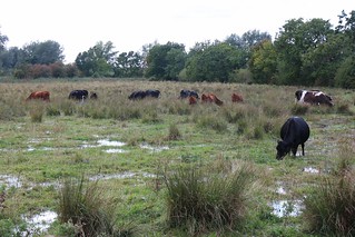
- Henlow Common consists of 45 acres of riverside flood meadows. It is a Local Nature Reserve which is open to the public, but the paths across it are not well-defined and the area can be boggy.
- Henlow Millennium Meadow is a small Community Nature Reserve, owned by the Parish Council.
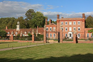
- The earliest parts of Henlow Grange date from 1680, but this Grade Ⅱ* building is mostly 18thC. Its last private owner was Alan Lennox-Boyd, MP for Mid-Bedfordshire who was Colonial Secretary in the 1950s. After he moved out the house fell into disrepair, but it was extensively refurbished by a new owner in 1961 and converted into a health farm. In 1981 it became the first of a chain of health spas branded as Champneys.
- The River Hiz (properly pronounced Hitch) is a short tributary of the River Ivel, flowing into it in the grounds behind Henlow Grange.
If you are doing the Longer Walk (via Biggleswade town centre), go to §E.
For the rest of this section there is a choice of routes, since the riverside path has deteriorated in a few places. The suggested route is to use a new parallel cycle / walkway, but the more scenic riverside path can still be used, with care (and if you do find it impassable there are gaps in the hedge boundary where you can switch routes).
If you are doing the Main Walk (to Arlesey), go to §G.
The suggested route is to follow the well-defined perimeter path around three sides of this site, but as an alternative you could take a more direct route along its eastern boundary. This is a little-used unofficial path but it has more extensive views of the central lake.
…
This is the preferred route for the rest of this section, but if permission has been withdrawn (or if the path has become impassable) you would have to take the alternative route in [?] through Langford village (which is still the published route of the Kingfisher Way).
The suggested route to complete the walk is a meandering path around the northern boundary of the campsite. If you are in a hurry to catch a train you can take the shorter route in [?].
Walk Notes
» Last updated: April 15, 2024
Return to Top | Walk Map | Walk Options | Walk Directions.