South West Coast Path: Seaton to Lyme Regis via the Undercliff walk
Jungle like walk through the Axmouth / Lyme Regis undercliff, with sea views at the start and finish
| Length |
6.7 miles (10.8 km) |
|---|---|
| Toughness | 4 out of 10 (6 when wet) with 1,350 ft (400 m) of ascent - 1 climb at the start then continuous small ups and downs over well maintained paths (but muddy and slippery path after wet weather). |
| OS Maps | OS Explorer 156 |
| Walk Notes |
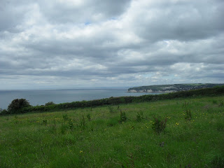
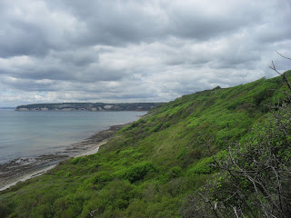
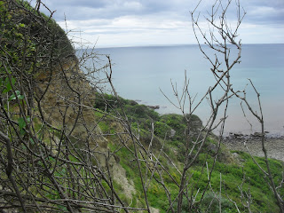
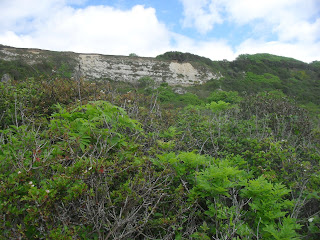
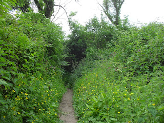
This interesting walk explores the Axmouth to Lyme Regis undercliff - an almost jungle like area of overgrown vegetation created by an 1839 landslip. While part of the South West Coast Path (SWCP), this is not a cliff top walk - there are sea views only at the start and finish. On Christmas Day 1839, a 5km x 1km x 200m section of cliff collapsed and slid downhill to create the undercliff. Houses at the top were still standing but at the bottom. The area is still active, and a now a 6km long, and up to 1km wide 'undercliff' has formed with dense vegetation. At first the undercliff was farmed, but now it is a National Nature Reserve full of self-seeded plants and trees. With the reduction in the rabbit population due to myxomatosis, a lush vegetation has formed, with a dense jungle of ferns, bracken, wild garlic and ash (trees). Sadly, English Nature is removing the non-native tropical plants that came from a former garden in the area. There is a well maintained and well waymarked path through the undercliff which forms part of the SWCP - many ascents and descents have wooden steps. Despite the warnings signs at either end, it is not too strenuous a walk - though there are many ups and downs, they don't last for long, especially by the standards of the SWCP, and any regular walker can easily complete it. The going is slower than normal, many tree roots to step over. The walk is much harder after wet weather, when the paths are covered by an inch of slippery mud. It is very 'enclosed' walk with much forest cover (ideal walk for spring flowers or a very hot summers day) - very different from the the rest of the SWCP. The path is up to 500m inland, with rare views of the sea. Along the way, there are 1 or 2 faint side paths leading down to the coast (access to which is discouraged by the Nature Reserve that manages the undercliff, presumably for their own amusement rather than for the benefit of the taxpayers who pay their salaries). There is a new permissive path linking to the cliff top at the Lyme Regis end of the undercliff, but there are no rights of way inland during the western half of the walk. There is a private track at the half way point should you need it in an emergency. Some of these side paths have/had steel ladders down to the beach at the bottom. If you do follow them, beware of glacier like fissures hidden by vegetation, and consider long trousers to protect yourself from the possibility of ticks The entire walk is on the SWCP. It starts on Seaton's seafront promenade, and detours inland, then uphill through a golf course (walkler friendly cafe) before returning to the cliff top with good views. After a short cliff top walk, you descend down into the undercliff. (1.5 miles)
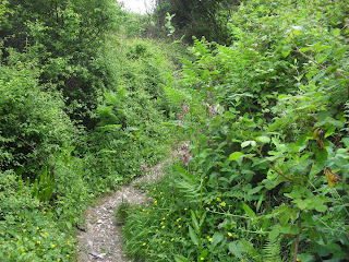
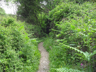
The next 5.5 miles or so are through a jungle like canopy of vegetation. The path is inland from the coast - the sea is rarely seen. It is undulating, but never too strenuous (but harder when wet and slippery). The path, while very well maintained (e.g. steps in many steep places) is only 1 person wide. There are 1 or 2 places with sea views that make nice spots for a rest, and a few remains of buildings at the half way point. Towards the Lyme Regis end of the walk, the path joins a paved tracked which is wider and easier. After the undercliff, the path enters National Trust land at Ware Cliffs, with views out to sea as far as the Isle of Portland and Torquay, and below, over the Cobb (harbour) at Lyme Regis After descending to the Cobb (harbour), the walk finishes along the busy and popular sea front promenade past many pubs and the tourist information office, to reach the bus stop to catch the bus back to your car in Seaton. When to do this walk: Spring is good for wild flowers. Winter is better for views when the trees have lost their leaves [2019]. The route is fully open after being closed by a 2016 landslip. The new path continues further along the cliff top at the Seaton end, before descending steeply to rejoin the original path. The 'bypassed' section passes 2 routes down to the coast. According to a local (a surfer), you can also get down to the coast by the old engine house at the half way point. To emphasise : there are many coast walks near here with spectacular views, but this is not one of them. Do it because of its interesting history. |
| Walk Options |
In reverseThe walk can be done in reverse, starting in Lyme Regis. Beach RouteExperienced walkers in dry weather on a falling tide only. Not recommended for solo walkers. The main walk is through the landslip area above the coast. You can also walk along the beach at the base of the cliffs instead. This is a very strenuous and remote option as you have to step from stone to stone for almost the entire way, even as low tide! You can start from the west (in Axmouth, follow the footpath at the base of the cliff past the fishing bait shop) or east (along Lyme Regis beach), but beware of:
On the plus side, there are many fossils (especially after a storm), and a hidden bay / shingle beach (Pinhay Bay) close to the Lyme Regis side, and you'll have a great sense of achievement. You could use the main walk to do a circular walk back to the start. Me, I preferred the bus, and a beer while I waited for it. To do a short out and back stretch, Lyme Regis is easier, and closer to Pinhay Bay (about 1.5km of stone hopping each way). Updated Aug-23 |
| Travel |
By car: EX12 4AA. Leave the coast road at the Axmouth turn off. Continue through Axmouth towards Seaton. Just before the bridge over a river at the start of Seaton, there is free parking along the side of the road. The SWCP goes over the bridge. Seaton itself has resident parking that goes a fair way inland athe new estate behind Tesco is OK, for now..., google Devon CPZ map). Street parking in Lyme is much harder, try the start of Ware Lane with has a footpath that leads down to the Cob. Holmbush long term car park (DT7 3HX) on the western approch to the town is £15 (summer), £9 (winter). Return to your car: Lyme Regis and Seaton are linked by a regular bus. Bus 378, Seaton - Lyme Regis (2 hourly), 25 mins, takes contactless. Check! Bus services change frequently. Lyme Regis and Seaton have hourly buses inland to Axminster (station). The Lyme Regis bus is on the Jurasic coast route : Axminster - Lyme Regis - Charmouth - Dorchester station or ( via the coast - Abbotsbury - Weymouth station ) |
| Lunch and Tea |
There is an outside cafe by the fish bait shop at the start in Seaton (down to the sea after the bridge), and the golf course cafe welcomes walkers. Otherwise, nothing on route. Lots of places in Lyme Regis at the end. |
| Seaton |
Seaton is a seaside town, larger but much quieter than Lyme Regis. For groups, there is a new Travelodge in Seaton, by a large Tescos. |
| Lyme Regis |
Lyme Regis is a major tourist attraction. It has an historic centre, sandy beach, and cobb (harbour), with quaint, narrow and winding streets with picturesque buildings, and a sandy bay with a pedestrian promenande with cafes/bars/shops - a nice place to wait for a bus. Parking is at a premium and expensive. Many small hotels. |
| Links |
|
| Tides |
23-Oct :
low: 04:28
high: 11:01
low: 16:50
high: 23:38
24-Oct :
low: 05:15
high: 11:52
low: 17:43
25-Oct :
high: 00:40
low: 06:19
high: 12:58
low: 19:11
26-Oct :
high: 02:07
low: 08:07
high: 14:26
low: 20:56
27-Oct :
high: 03:00
low: 08:30
high: 15:05
low: 20:57
28-Oct :
high: 04:06
low: 09:25
high: 16:11
low: 21:43
29-Oct :
high: 04:44
low: 10:08
high: 16:54
low: 22:22
Times for . Corrected for BST if appropriate. Contains ADMIRALTY® tidal data: © Crown Copyright and database right.
|
|---|---|
| Profile | |
| Help Us! |
After the walk, please leave a comment, it really helps. Thanks! You can also upload photos to the SWC Group on Flickr (upload your photos) and videos to Youtube. This walk's tags are: |
| By Car |
Start Seaton, Devon Map Directions Finish Lyme Regis, Dorset Map Directions |
| Amazon | |
| Help |
National Rail: 03457 48 49 50 • Traveline (bus times): 0871 200 22 33 (12p/min) • TFL (London) : 0343 222 1234 |
| Version |
Aug-23 Andrew |
| Copyright | © Saturday Walkers Club. All Rights Reserved. No commercial use. No copying. No derivatives. Free with attribution for one time non-commercial use only. www.walkingclub.org.uk/site/license.shtml |

Walk Directions
This walk is very well waymarked - apart from the locations of the bus stops, these instructions aren't really needed
- Follow Harbour Road (the main road about 30m back from the sefront) east. At the end of town, you come to a road bridge over the rive Axe (with an older, now pedestrian bridge next to it). The bus stop is on the town side of the bridge. Cross the bridge, following SWCP signs.
- To your right is a small road, beneath the hill, along side the harbour leading to a cafe by a fish bait shop, and a footpath that leads to the end of the beach, and shingle beneath the cliffs.
- Continue along the road, heading inland. Turm right, following SWCP signs, leading uphill to a golf course.
- Pass the golf course club house (and walker friendly cafe), and continue following SWCP signs across the golf course.
- Turn right, following SWCP signs leading to the cliff top, then left along the cliff top
- The old (now blocked) path started here.
- Continue along the cliff top, and then steeply downhill (stairs) into the undercliff.
- Continue ahead, ignoring 1 or 2 ways off to the coast (marked by SWCP signposts). The "old" route joins at a signpost.
- Pass the ruins of a pumping station after 3 miles. A path down starts here.
- Pass 2 signs (with information panels), heading inland along permissive path (not walk tested, might be a nice cliff top alternative with views down over the undercliff)
- Eventually you join a wider tarmac path, and leave the undercliff via National Trust land
- Continue along the well waymarked SWCP, pass a viewpoint. Either continue ahead to the cliff top car park, or following the SWCP, and descend down to Lyme Regis seafront and a car park.
- Follow the seafront to a square, then a promenande for about 0.5 miles passing many pubs and cafes until you reach a small car park.
- Inland, by the clock tower is the bus stop.