St Margarets Circular walk
Quiet rolling Hertfordshire countryside, a haunted, ruined church and long stretches in scenic river valleys.
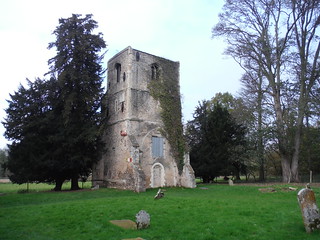
Thundridge Old Church
SWC Walk 165 - St. Margarets Circular
Nov-17 • thomasgrabow on Flickr
swcwalks swcwalk165 banner 24402487438
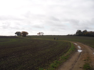
Approaching Cold Christmas
SWC Walk 165 - St. Margarets Circular
Nov-17 • thomasgrabow on Flickr
swcwalks swcwalk165 walkicon 24402497648

The Ash River Valley
SWC Walk 165 - St. Margarets Circular
Nov-17 • thomasgrabow on Flickr
swcwalks swcwalk165 walkicon 38273253071
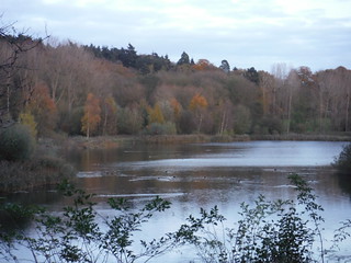
Hollycross Lake in Autumnal Colours
SWC Walk 165 - St. Margarets Circular
Nov-17 • thomasgrabow on Flickr
swcwalks swcwalk165 walkicon 38241570902

Amwell Nature Reserve
SWC Walk 165 - St. Margarets Circular
Nov-17 • thomasgrabow on Flickr
swcwalks swcwalk165 walkicon 24402424128
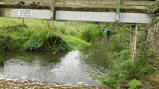
Ash river survey
and they're definitely not walkers...well, not today anyway
Sep-13 • magyardave2002 on Flickr
book3 swcwalks walk165 9815586244

Hen party
Well, what were you egg-specting?
Sep-13 • magyardave2002 on Flickr
hens book3 swcwalks walk165 9815582005
| Length | 24.1 km (15.0 miles), with 258m ascent/descent. For a shorter or longer walk see below Walk Options. |
|---|---|
| Toughness | 4 out of 10, with 5 hours 15 minutes walking time. For the whole outing, including trains, sights and meals, allow at least 8 hours. |
| Walk Notes |
This walk leads along ancient tracks and green lanes through some very quiet, rolling East Hertfordshire countryside defined by wheat fields and woods, in-between extensive stretches along the Ash, Rib and Lea rivers. Cold Christmas hamlet and a haunted, ruined church are passed just before lunch in Wadesmill.
Stile Count: 3; Arable Field Crossings: 330 metres. |
| Walk Options |
Outbound and return route are never far from each other, sometimes as little as 150 metres. See the route map for some obvious and easy-to-follow shortcuts.
An Extension from Wadesmill adds 1.6 km (1.0 mi) and 12m ascent/descent (5/10). Buses to Ware or Hertford train stations (one or two stops further from London on the same line) are available from the lunch pubs in Wadesmill (line 331; hourly Mon-Sat) and Wareside (lines M3 and M4; with 2 buses in the afternoon, Mon-Sat). |
| Maps | OS Landranger: 166 (Luton & Hertford) and 167 (Chelmsford, only for a very tiny part)
OS Explorer: 194 (Hertford & Bishop’s Stortford) |
| Travel | St. Margarets Station is on the Liverpool Street to Hertford East line (and within the Oyster Pay As You Go-area) with a half-hourly service, journey time 39 minutes (41 on Sundays). Trains stop at Tottenham Hale (connect from the Victoria Line). Buy a return to St. Margarets (Herts).
Saturday Walkers' Club: Take the train closest to 9.45 hours, if walking the full walk, and the one closest to 10.15 hours for the shortest version. |
| Lunch |
Long Walk
Short Walk
|
| Tea |
The Jolly Fisherman 8 Station Road, Stanstead St. Margarets, Ware, Herts, SG12 8DH (01920 870 125). A McMullen’s pub with outdoor seating by the Lea Navigation.
|
| Profile | |
|---|---|
| Help Us! |
After the walk, please leave a comment, it really helps. Thanks! You can also upload photos to the SWC Group on Flickr (upload your photos) and videos to Youtube. This walk's tags are: |
| By Train |
Out (not a train station) Back (not a train station) |
| By Car |
Start SG12 8DS Map Directions |
| Amazon | |
| Help |
National Rail: 03457 48 49 50 • Traveline (bus times): 0871 200 22 33 (12p/min) • TFL (London) : 0343 222 1234 |
| Version |
Apr-24 Thomas G |
| Copyright | © Saturday Walkers Club. All Rights Reserved. No commercial use. No copying. No derivatives. Free with attribution for one time non-commercial use only. www.walkingclub.org.uk/site/license.shtml |


Walk Directions
Full directions for this walk are in a PDF file (link above) which you can print, or download on to a Kindle, tablet, or smartphone.
This is just the introduction. This walk's detailed directions are in a PDF available from wwww.walkingclub.org.uk