Tenterden to Rye walk
A varied landscape between two interesting Cinque Port towns, from the low hills of the eastern High Weald almost to the coast.

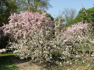
DSCF7383
Orchard at Wittersham
Apr-11 • Sean O'Neill
swcwalk113, swcwalks, walkicon 5599937285401627042 P

CIMG2602
Ss Peter & Paul Church, Peasmarsh
Apr-12 • Sean O'Neill
swcwalk113, swcwalks, walkicon 5734152439024132194 P
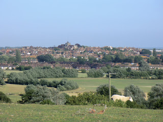
CIMG8341
Distant view of Rye
Aug-13 • Sean O'Neill
swcwalk113, swcwalks, walkicon 5908010045417872722 P
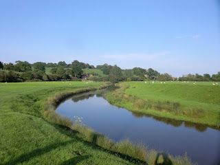
CIMG1733
The River Tillingham
May-14 • Sean O'Neill
swcwalk113, swcwalks, walkicon 6020079491190016018 P

1103050086
A tricky stretch in the Tillingham valley before...
Mar-11 • Sean O'Neill
swcwalk113, swcwalks 5599938173919524178 P

1103230001
St Mildred's Church, Tenterden
Mar-11 • Sean O'Neill
swcwalk113, swcwalks 5599935938555267234 P
| Length |
Main Walk: 21½ km (13.4 miles). Five hours walking time. For the whole excursion including trains, sights and meals, allow at least 11 hours. |
|---|---|
| OS Map |
Explorer 125. Tenterden, map reference TQ884333, is in Kent, 16 km SW of Ashford. Rye is in East Sussex. |
| Toughness |
4 out of 10. |
| Features |
The inspiration for this walk came from studying the High Weald Landscape Trail (HWLT). The final section of this long-distance path joins two interesting towns, both members of the historic Confederation of Cinque Ports. The landscape between them is nicely varied, with flat grazing marshland in wide river valleys interspersed with low hills containing steeply-sloping wooded valleys (gills), fields and orchards. Most of the walk follows this well-waymarked published trail, with small detours at Wittersham and Peasmarsh. Before you set off from the picturesque town of Tenterden, which calls itself the “Jewel of the Weald”, it is worth taking a preliminary stroll along the wide tree-lined High Street with its many historic buildings. The first part of the walk proper features an attractive wooded valley on its way to the hamlet of Small Hythe, a major port in medieval times before the River Rother changed its course. Smallhythe Place was the harbourmaster's house; later it became a farmhouse and in the early 20thC was the home of the Victorian actress Ellen Terry. It is now owned by the National Trust and is open Wed–Sun from March to October; admission is £11 (2024). The route continues across Reading Sewer and climbs onto the Isle of Oxney, an area of high ground which at one time was surrounded by the sea and river channels. A detour off the HWLT through an attractive wood brings you to a lunch stop in the village of Wittersham. In the afternoon the route crosses the Rother Levels, where the wide river is popular with anglers. It then climbs gently through pastures and a wood towards Peasmarsh and a possible mid-afternoon break. The walk concludes with a gradual descent past orchards into the open valley of the River Tillingham, one of three rivers flowing towards Rye. Perched on its sandstone outcrop, Rye was an important port before its rivers silted up and the sea receded. Its cobbled streets and elegant historic buildings are well worth exploring, but you will probably arrive too late to visit those like Lamb House which are open to the public, or the town's Castle Museum in Ypres Tower. |
| Walk Options |
There are no specific options but you could use local bus services to shorten the walk (see Transport below). A disadvantage of starting from Tenterden is that you are heading towards the sun for much of the day. You could do the walk in the reverse direction, but note that there is a reduced bus service from Tenterden in the evening. |
| Transport |
Tenterden Town station (on the heritage Kent & East Sussex Railway) is sadly of no practical value, so you need to complete your outward journey by bus. Two feasible routes are Arriva 12 from Headcorn and Stagecoach 2/2A from Ashford International (both daily). Buy a return to Rye, which is valid to both these stations. Rye is on the Ashford–Hastings line, which has an hourly service. It is quicker to return to London via Ashford. Regular services go from there to Charing Cross and Victoria, or for a small premium you could take the High Speed Train to St Pancras. If you only want to do part of the walk, Stagecoach 312 runs between Tenterden and Rye, calling at Small Hythe and Wittersham, while Stagecoach 313 would take you from Peasmarsh to Rye (both Mon–Sat). The walk is not feasible for car drivers on Sundays, but when the 312 is running you could park in Rye and take the bus to Tenterden, alighting at Lloyd's Green (Wittersham) or Small Hythe if you wanted to do a shorter walk. The station car park costs £2.90 Mon–Sat (2022). |
| Suggested Train |
Aim to start the walk no later than 11.30am. On the current timetable you could do this by leaving London at around 09:40, travelling from Charing Cross to Headcorn (for Arriva 12), or St Pancras to Ashford International (for Stagecoach 2/2A). |
| Train Times |
|
| Timetables |
|
| River Levels |
|
| Lunch |
The intended lunch place for this walk (after 8 km) was the Swan Inn (01797-344444; currently open lunchtime Sat & Sun only) in Wittersham, but this village pub has had long periods of closure. For a few years it became the Oxney Gourmet Pie and Burger Bar, but this too closed at the end of 2018. It reopened as the Swan Inn in June 2022 but with limited opening hours; you would need to call ahead to check if it was open and serving food. The churchyard and orchards nearby would make suitable picnic spots; alternatively, you could stop earlier for a light lunch at Smallhythe Place. There are no other refreshment places on or near the walk route until you reach Peasmarsh, much further on. |
| Tea |
If you need refreshment in mid-afternoon, the good-value café in Jempson's Peasmarsh superstore (01797-230214) is open until 4pm (Mon–Sat). Stronger fare is available nearby at the Cock Inn (01797-230281). There are many more options at the end of the walk in Rye, although its enticing tearooms will probably have closed by the time you arrive. Freshly caught fish & chips from the shop on the quay would be a good choice, while for liquid refreshment the town boasts many historic pubs: the Mermaid Inn (01797-223065) in Mermaid Street is the most famous, while the Ypres Castle Inn (01797-223248; open Thu–Sun & BH Mon) has fine views over Romney Marsh from its elevated position next to Gun Gardens, near the church. |
| Profile | |
|---|---|
| Help Us! |
After the walk, please leave a comment, it really helps. Thanks! You can also upload photos to the SWC Group on Flickr (upload your photos) and videos to Youtube. This walk's tags are: |
| By Train |
Back (not a train station) |
| By Car |
Start Tenterden, Kent Map Directions Finish TN31 7AB Map Directions |
| Amazon | |
| Help |
National Rail: 03457 48 49 50 • Traveline (bus times): 0871 200 22 33 (12p/min) • TFL (London) : 0343 222 1234 |
| Version |
Apr-24 Sean |
| Copyright | © Saturday Walkers Club. All Rights Reserved. No commercial use. No copying. No derivatives. Free with attribution for one time non-commercial use only. www.walkingclub.org.uk/site/license.shtml |


Walk Directions
Click the heading below to show/hide the walk route for the selected option(s).
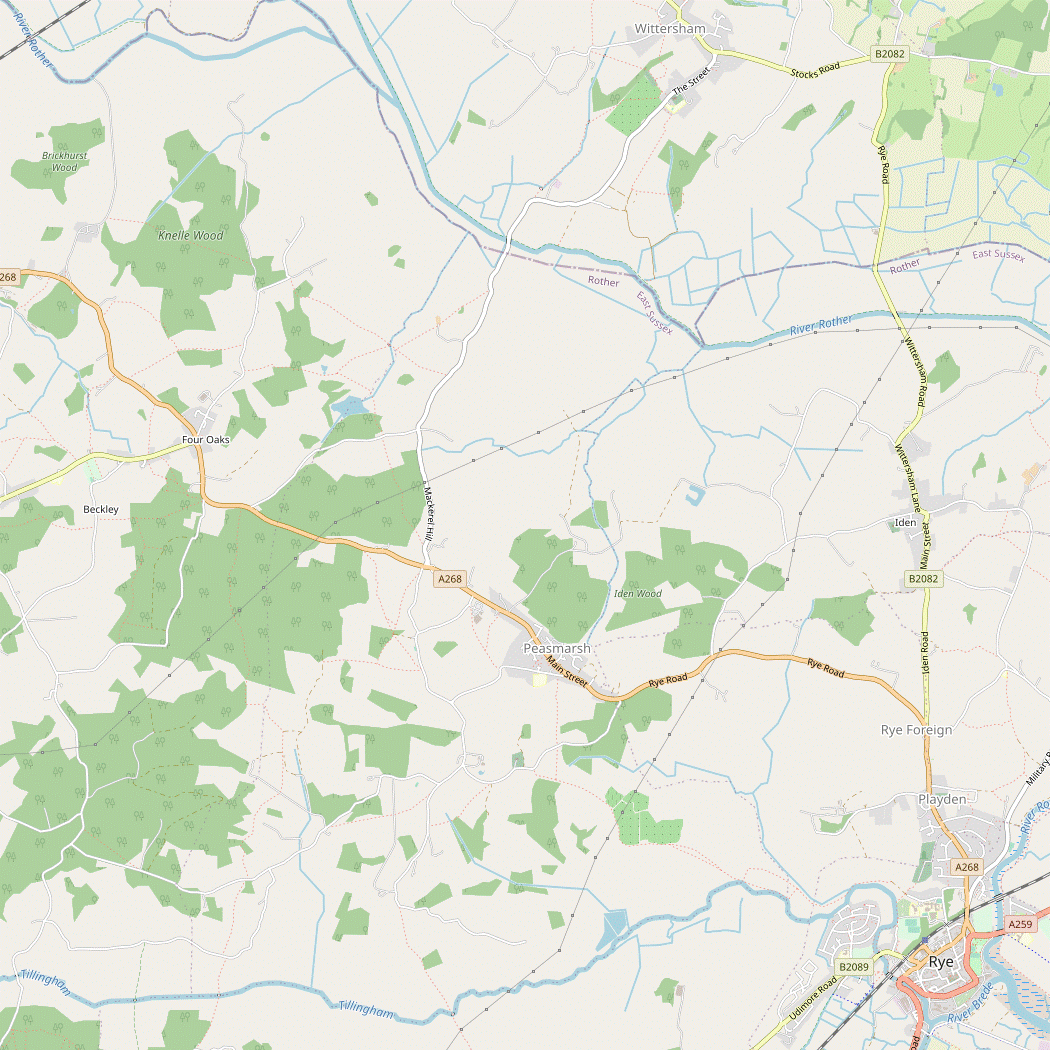


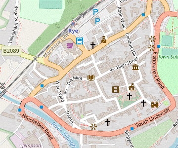
 Walk Maps
©
Walk Options
Click on any option to show only the sections making up that route, or the heading above to show all sections.
- Main Walk (21½ km)
Walk Directions
Click on any section heading to switch between detailed directions and an outline, or the heading above to switch all sections.
If you take bus 312 to Small Hythe, start at §B.
If you take bus 312 to Wittersham, start at §C.
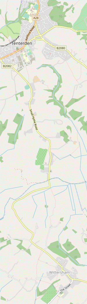
- Tenterden to Small Hythe (5 km)
-
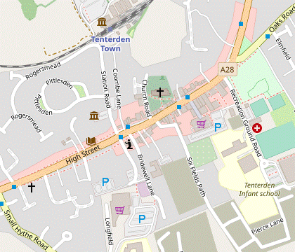 Make your way to the pedestrian lights on the High Street by St Mildred's church. Head south down a passageway called Bells Lane into Six Fields Path and carry on in this direction for 1 km. At the B2082, turn left onto the driveway to Belcot Manor Farm. Just before the farm, bear right across fields and down into Tilder Gill. Follow the path alongside the stream, then past a lake. Continue across fields, gradually curving round to the right to rejoin the B2082 at Small Hythe. Turn left onto the road and go past Chapel Down Winery and the church to Smallhythe Place.
-
Make your way to the pedestrian lights on Tenterden's High Street? by St Mildred's church?, where there is a signpost for the High Weald Landscape Trail? (HWLT).
The directions will indicate where you leave and rejoin this well-waymarked trail.
- Before starting the walk you could take a preliminary stroll along the attractive High Street, perhaps even continuing down Station Road to the Kent & East Sussex Railway?.
- From the lights head S down the passageway called Bells Lane, which soon opens out and goes past some charming old cottages. Carry on in this direction for 1 km, initially through a new housing estate on Six Fields Path and then past fields and a nursery. The path eventually comes out onto the B2082.
- At this junction turn left into the second of two driveways (not the one into the nursery), with a hedge on your left. After 300m along the drive, just before a sign for Belcot Manor Farm, go over a step-stile in the fence on the right.
- Turn half-left on the other side to head SE on a faint grassy path, skirting a large pond on the left. In 200m go over a stile and bear left to go alongside a small projecting piece of woodland.
- At the end of the trees go round to the left into another large field and continue near its right-hand edge, with a wooded valley on your right. At the corner of the field turn right and go down steps into Tilder Gill, an attractive steep-sided wooded valley.
- Head S and later SE alongside the stream on the woodland path, which soon crosses to the other side of the main stream. You eventually go through a wooden gate and maintain direction along the right-hand side of a grassy area, staying close to the gill.
- About 1 km after entering Tilder Gill you come to a lake on your left-hand side and continue alongside it, heading SE. At the end of the lake go down steps and keep ahead, still with the stream on your right. In 100m the path bends right to head S and you continue across several stiles and ditches.
- In 400m, with farm buildings and two oast houses off to your right, go through a slightly overgrown area and bear left across the grass ahead. Go through a metal fieldgate to continue on the left-hand side of a tall hedge, heading SW. At the end of the hedge continue in the same direction (with no clear path) over a slight rise.
- In 200m go over the right-hand of two footbridges in a hedge to cross a ditch and bear right on a grassy path; this gradually approaches a line of trees on the left which you continue alongside, now heading W. 300m from the footbridge, bear left through a gap in the trees into the corner of a rectangular field.
- Go across this small field to a gap in the hedge near the middle of the far side, which leads into the bottom corner of another field. Bear left to go diagonally across this to the top corner. Go over a stile here and follow a fenced path heading W out to the B2082.
-
Turn left onto the road through the hamlet of Small Hythe?, passing Chapel Down Winery?, then the brick-built church of St John the Baptist? and Priest's House. After 500m you reach the picturesque Smallhythe Place on your left.
- Small Hythe to Wittersham (3 km)
- Continue south along the road, crossing Reading Sewer. Where the road turns right, keep ahead on a footpath going across the marshland and then uphill along field edges to Kingsgate Farm. Turn right onto its driveway. Just after passing a house called Coom Bank, turn left into Comb Wood and follow a south-easterly route for about 500m. At the edge of the wood, turn right onto a public footpath and follow this out to the B2082 at Lloyd's Green, Wittersham. Turn left onto the road to come to the village pub at the junction with Swan Street.
- Continue S along the road for a further 250m, crossing Reading Sewer?. Where the road turns right, keep ahead on a footpath. Go over a metal fieldgate with a built-in wooden stile and continue across the marshland between two reed-filled drainage ditches. You are going to be climbing the low hill ahead, the Isle Of Oxney.
- At the end of the ditches go through a fieldgate in the hedge ahead and bear right towards the top right-hand corner of a field (or simply go round its edge). Go through an old gate here and turn right for a short distance as indicated, then through another gate into the corner of a large field. Turn left and go up its left-hand edge, heading S again.
- In the next corner turn right. Follow the top field edge for 100m and then turn left through a metal fieldgate into another field. Go uphill towards some houses on the horizon, with a hedge on your right. About 50m before the top of the field, ignore a fieldgate on the right, but just past this go through a metal kissing gate onto an enclosed path. This curves round to the left between two properties and comes out onto a gravel driveway.
-
Turn right onto the driveway and follow it out past a gate, heading S again. Keep ahead on the main drive between hedges, later with a fine view back to your left. In 500m it bends left and then passes an isolated house (Coom Bank). Instead of following the drive as it turns right, turn left onto an earth track going past the house into Comb Wood, leaving the HWLT.
The paths through Comb Wood are not shown on the OS map but they are clearly well-used by locals; there is a well-maintained stile on the far side and no signs indicating that the wood is private. In contrast, the route into Wittersham along public footpaths (not described here) involves crossing a large ploughed field.
- The suggested route through this attractive wood (not the shortest) starts by forking left downhill. The woodland path gradually curves round to the right to head SE, later climbing gently with a stream in the steep-sided valley below on your left. The path becomes less distinct but essentially you continue in the same direction to join a wider path coming in from the right. This leads to a stile in the fence at the edge of the wood.
- You could go over this stile and turn right (onto an overgrown public footpath), but just before the stile an easier route is to follow the woodland path round to the right, to go between a line of trees and a wire fence. At this corner of the wood there is a gap between the trees on your left which takes you out onto a driveway, the continuation of the footpath.
- Turn right and go along the fenced driveway between houses to the B2082 at Lloyd's Green, Wittersham. Turn left and follow the road round to the right to find the Swan Inn on the other side of the junction with Swan Street.
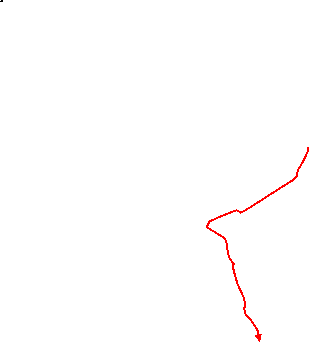
- Wittersham to Blackwall Bridge (2½ km)
- Head south-west along Swan Street and take the first footpath on the left. Go across a field, Bate's Gill and an orchard onto a path leading towards Wittersham's church. Before reaching a road, turn right into the corner of a larger orchard and go diagonally across it back towards the gill. Head south-west alongside it, crossing to the other side at one point. Join a road and follow it to Blackwall Bridge.
- From the road junction in front of the pub head SW along Swan Street, passing the pub on your left. In 150m, shortly after passing a footpath going off to the right, turn left at a footpath sign to go along a short path into a field. Turn half-right to follow a grassy path heading S. On the far side of the field cross the wooded Bate's Gill via gates and a footbridge, emerging into an orchard.
- Turn half-right again to head S through the orchard. On the far side go through a kissing gate and turn left onto a fenced path (rejoining the HWLT), at first with a cemetery on your right and then a field. Unless you want to make the short detour below, go through a kissing gate on the right into the corner of this field.
-
Detour to Wittersham church (+200m)
- To visit the church of St John the Baptist?, keep ahead along the tarmac path and cross a lane to reach it. Return the same way.
- Inside the field bear right to go diagonally across it, heading SW. Eventually you need to go alongside the wooded Bate's Gill ahead on your right; the right of way goes through a gap in the hedge ahead into an orchard and continues in much the same direction (it is better to veer too far to the right and then turn left at the edge of the orchard, rather than go past the exit).
- If you have been walking along the edge of the orchard with Bate's Gill on your right, you will come to a stile. Go over this into the top corner of a large sloping field and make your way down to a stile in its bottom right-hand corner. Go over this onto a track and turn right to cross a tree-lined stream, then immediately turn left onto a fenced path running alongside the trees.
- Continue along the left-hand edge of several large fields for 750m, heading S and later SW until you reach a road at a bend. Turn right onto the road to continue in the same direction, taking care as there is no pavement. In 400m you cross the wide River Rother? at Blackwall Bridge and for the next 2 km join the Sussex Border Path?.
- Blackwall Bridge to Flackley Ash (3½ km)
- Continue south along the road for a further 400m, then take a footpath on the right which heads south-west over some low hills. After about 1½ km turn left in a field and follow a path south-east around Decoypond Wood. Go across Kitchenour Lane (slightly to the right) and continue south-east on a path across a large field, then through Mill Wood. Go along a lane to its junction with the A268 at Flackley Ash.
- Continue S along the road for a further 400m. Opposite a large house, go over a stile on the right to go through a small wood. After leaving the wood you head SW in a straight line for 800m across open fields: up and over a small hill, to the left of some farm buildings, then uphill again; aim for the corner of a wire fence which comes into view and keep ahead, with the fence on your right.
- In the corner of this field go over a stile on the right onto a short fenced path. In 50m cross a drainage channel on a concrete slab and then turn left to cross a wooden footbridge. Go over a stile and head SW across another large field, gently uphill.
-
In 300m cross a stile to go along the short edge of a field. In the next corner go over yet another stile into a large area of pasture, with a lightly wooded area ahead. Continue in much the same direction up to the trees and turn left to go alongside them; as they thin out you will see a lake 100m away to your right.
There used to be waymarkers and a rather fussy notice insisting that walkers follow this route precisely; the right of way presumably follows old field boundaries.
- At the end of the field keep ahead through a potentially muddy area. Go through a metal fieldgate and turn half-right, alongside a wire fence on your right. At the end of the fence cross a track leading down to the lake and bear slightly left up a slope into a lightly wooded area. At the top go through a metal fieldgate into a small wood. Follow a faint path through the trees, then out past some houses to a narrow lane.
- Turn right onto the lane, then almost immediately turn left at a footpath signpost to go through a belt of trees. Go over a stile and keep ahead across a large field with no clear path. As you go over a small rise in the middle of the field and start to go gently downhill you should be able to see a stile leading into the wood ahead, about 100m in from the left-hand corner.
- Go over the stile and follow a clear woodland path in much the same direction for 600m, ignoring turnings off and at one point going across a wide clearing with electricity pylons. The path eventually comes out onto a lane and you bear right onto it. You soon come to a fork in front of a small triangular green containing a weeping willow, with the A268 up ahead.
- Flackley Ash to Peasmarsh Church (2 km)
-
For some mid-afternoon refreshment in a supermarket café or pub, turn left onto the A268 towards Peasmarsh. Jempson's superstore is on the right, just before the Cock Inn. Continue on footpaths behind the café or pub to a lane, turn right and take a footpath across fields to Peasmarsh church.
- Alternatively, head south along a quiet country lane, skirting the village. Take a footpath heading south-east through an avenue of lime trees and across a field to the church.
-
Route through village
- Bear left at the small green, cross over the A268 carefully and turn left. To avoid part of this stretch alongside the main road immediately fork right down an unsurfaced driveway leading to several houses, which rejoins the main road 200m further along.
- Continue downhill on the main road for 200m. At the junction with Tanhouse Lane (with a large sign for Jempson's superstore) there is another choice of routes, depending on whether you want to visit a café or a pub.
-
Route via Jempson's café
- Turn right into Tanhouse Lane and then left into the store's car park. Bear right towards the main building; Jempson's café is at the front of the store.
- Afterwards, unless you want to return to the main road to try the Cock Inn, bear left out of the store. Go through a gap in the low wooden fence and turn sharp left.
- Go over a stile and up a fenced path on the left-hand edge of a field, heading S. At the end of the field go over a stile on the left and continue along the right-hand side of two paddocks.
-
Route via the Cock Inn
- Continue on the A268 past Tanhouse Lane, now going gently uphill. The Cock Inn is on the right after 150m, set back from the road.
- Afterwards, unless you want to return to Tanhouse Lane to try Jempson's café, leave the pub at the back (or from the road, go round its left-hand side) and go through a caravan site to its far left-hand corner.
- Go over a stile and across a small field. Go over another stile into a paddock and make for its far left-hand corner.
- In a potentially very muddy area go over a stile and continue on a track past stables and a house to a lane. Turn right onto the lane, leaving the HWLT. In 50m, as the lane bends right, go over a stile on the left and turn right alongside the hedge, climbing gently for a further 50m.
- At the top of the slope turn left onto a path across the field towards some trees, heading S. On the far side take a path through the wooded gill, crossing the stream on a footbridge. Bear left to head SE for 400m across a large field, towards Peasmarsh church.
- Go through a wooden kissing gate into the churchyard, with Peasmarsh Place? across the field to the right. The entrance to the isolated church of Ss Peter and Paul? is on the far side.
-
Route bypassing village
- Bear right at the small green (leaving the HWLT) and cross over the A268 carefully to head S on Mill Lane. In 500m turn right at a T-junction and follow the lane round to the left, heading S again.
- In 500m the lane curves round to the left, climbing gently. After heading SE for 200m (with fine views off to the left) the lane comes to a Y-junction. Do not take either fork but go straight ahead through a metal fieldgate onto a broad grassy avenue between mature lime trees.
- At the end of the avenue go through a dip, over a stile, and up the other side (slightly to the right). Follow a faint grassy path for 400m across a large field, heading SE towards Peasmarsh church.
- …
- Peasmarsh Church to Rye (4 km)
- Head south out of the churchyard. Turn left onto a lane, then fork right onto a track leading to Clayton Farm. Continue through the farm, past orchards and out onto an open valley. Go down the valley towards Rye, later with the River Tillingham on your right. Follow the river as it curves round to the right in a wide loop. The footpath eventually joins a tarmac path leading to Tillingham Avenue on the outskirts of Rye.
- Head south out of the churchyard on its driveway and turn left onto a lane. In 150m, where the lane bends left, fork right onto a track leading to Clayton Farm, signposted as a public bridleway. In 250m the HWLT rejoins from the left, on a path through an orchard.
-
The track continues through the farm and then winds its way downhill past orchards. Eventually you go through a metal fieldgate to emerge at the top of an open valley.
Rye church is straight ahead, 2½ km away; on a clear day you might also be able to see a wind farm? beyond the town and the Nuclear Power Stations at Dungeness in the far distance.
- Keep ahead past a derelict brick barn and follow the track gently downhill, with a hedge on your left. In 200m pass to the right-hand side of a ditch and aim for a metal fieldgate in the wire fence ahead. Go through this and down towards a new footbridge in the hedge at the bottom of the slope. After crossing this keep ahead towards a corrugated metal outbuilding. Go past this and through a metal gate, with the River Tillingham on your right.
- On the other side of this gate the OS map shows the bridleway as heading slightly to the left across the low-lying ground, but if there is no clear path the suggested route is to keep ahead alongside a low embankment for about 350m. You pass two large willow trees and then follow a faint grassy path round to the left, away from the river. In 100m turn right through a metal fieldgate (the direct route should have led you to this point).
- On the other side of the gate keep ahead across the grass, soon with a wide drainage ditch on your left. In 200m follow this round to the left, with a housing estate on the outskirts of Rye off to your right. Eventually the river rejoins from the right and you go through a metal fieldgate by a sluice gate to continue alongside it.
- In 250m go across a wooden footbridge in a hedge and keep ahead (slightly to the left). This takes you between a prominent brick house and a drainage ditch, after which you veer right to rejoin the riverside embankment. Follow this up to a metal kissing gate and turn right onto a tree-lined tarmac path, still with the river on your right and now heading S. In 200m you reach some houses at the end of Tillingham Avenue, with the river curving away to the right.
- Through the town to Rye Station (1½ • ½ km)
-
 To explore the town centre, bear right across a meadow to return to the riverside path. Cross the B2089, go past Rye Windmill and across the railway to the A259. Continue along Strand Quay and fork left up a side street into the town centre. If you go up Mermaid Street and West Street to the church, return down Lion Street and zig-zag left and right for the station.
-
Alternatively, take a path alongside Tillingham Avenue to the B2089, cross the railway and turn left to reach the station directly.
-
Alternatively, take a path alongside Tillingham Avenue to the B2089, cross the railway and turn left to reach the station directly.
-
Main route (1½ km)
-
Fork right off the tarmac path onto a short track leading into a meadow. Go straight across it on a broad grassy path and past some flats to the B2089.
- Cross over the road and continue on the riverside path. At Rye Windmill? follow the path across the railway tracks to reach the A259 at a roundabout, with a popular fish'n'chip shop on the left.
- For the town centre follow the main road alongside Strand Quay, still with the river on your right. After passing the Rye Heritage Centre? fork left up a side street, passing the Mermaid Street Café at the bottom of this cobbled street.
- Go up this pedestrianised street, passing the famous Mermaid Inn? on the left. At the top turn right into West Street. Follow the road round to the left past Lamb House? to come to St Mary's church? (its entrance is on the left-hand side).
- For a fine view across the marshland, make your way to the far right-hand corner of the churchyard and bear right past Ypres Tower? into Gun Garden. Another historic pub, the Ypres Castle Inn, is down a flight of steps on the left.
-
The station is about 500m from the church. A simple way to complete the walk is to go down West Street (from the top of Mermaid Street) or Lion Street (from the church) to the High Street.
- From the Mermaid Inn, you could also take an alleyway from the back of its car park and turn right at the bottom to reach the High Street.
- From the High Street go down Market Road, between West Street and Lion Street. At the bottom go straight across Cinque Ports Street and along Station Approach to the station building. A few rush-hour trains to Ashford leave from Platform 2 on the near side, but you will normally need to cross the footbridge on the right to Platform 1.
-
Direct route (½ km)
- Keep ahead on the tarmac path, initially alongside Tillingham Avenue. After veering left to go round the back of some houses the path comes out onto the B2089.
-
Turn left onto the road and cross the tracks at the level crossing. Turn left along Station Approach to reach the station building.
…
- Tenterden was described as “a singularly bright spot” by William Cobbett in his classic Rural Rides, although his judgement might have been swayed by the presence of “a great many very, very pretty girls” emerging from church in their Sunday best.
- St Mildred, Tenterden dates from the 12thC. Its large size and prominent tower (added in the 15thC) reflects the town's prosperity in medieval times.
- The High Weald Landscape Trail runs for 145 km across the length of the High Weald, mostly near its northern edge, from Horsham in West Sussex to Rye.
- The Kent & East Sussex Railway ran from Robertsbridge to Headcorn. It retained its independence until 1948 but was rarely profitable and closed in 1961. The restored heritage railway runs between Tenterden and Bodiam, often featuring in period films and TV programmes.
- Small Hythe declined after the River Rother changed course in the 13thC and the remaining waterway gradually silted up. In 1514 a major fire destroyed the town's medieval buildings, apart from Priest's House and the harbourmaster's house, Smallhythe Place.
- Chapel Down Winery is one of England's leading winemakers, with 22 acres of Bacchus, Chardonnay, Pinot Noir and Pinot Blanc grapes. Visitors are invited to wander around the vineyards and visit the shop, although there is a fee for guided tours.
- St John the Baptist, Small Hythe was built a few years after the 1514 fire destroyed an earlier chapel. Brick-built churches are unusual and the gables suggest a Dutch influence.
- The wide drainage ditch known as Reading Sewer is all that remains of a tidal channel (the original course of the River Rother) which could once only be crossed by ferry.
- St John the Baptist, Wittersham dates from the 14thC, although the striking tower was still under construction in the early 16thC.
- After heavy rain and high tides the River Rother overflows its embankment and the area to the right of the road after Blackwall Bridge temporarily becomes Lake Wittersham.
- The Sussex Border Path runs for 240 km along the length of West & East Sussex, from Thorney Island on the Hampshire border to Rye.
- Peasmarsh Place, the large Georgian house to the west of the church, was originally the rectory. It is now a residential care home.
- The oldest parts of Ss Peter and Paul, Peasmarsh, are Norman, dating from about 1070. The church is 1 km south of the present village, suggesting that the medieval population was struck down by the Black Death and the survivors re-settled away from the old village.
- The Little Cheyne Court Wind Farm was developed by Npower despite objections from local environmental organisations. Its 26 turbines have been operational since 2009, with a combined capacity of 60 MW.
- The white smock Rye Windmill was rebuilt in 1932 after a fire; there has been a windmill on this site since the 16thC. The building has been a B&B since 1984.
- The Rye Heritage Centre on Strand Quay includes a detailed model of how the town looked in 1872, constructed by two volunteers in the 1970s.
- The Mermaid Inn is a Grade Ⅱ* listed 15thC inn with Tudor additions. It was the local base of the notorious Hawkhurst Gang of smugglers in the mid-18thC.
- The elegant Lamb House was built in 1723 for the town's mayor, James Lamb. It was the home of the American writer Henry James from 1898 to 1916, and was later rented by the author of the “Mapp and Lucia” novels, EF Benson.
- St Mary the Virgin, Rye dates from 1150 but suffered major damage in 1377 when its bells and other valuable items were looted to France (though later recovered). Its prominent tower has acted as a shipping beacon for centuries.
- Ypres Tower was probably built in the 14thC (not 1249 as previously thought). It was part of Rye's defences against French raids but was unable to prevent much of the town being destroyed in 1377. It now houses the Rye Castle Museum.
The buses from Ashford and Headcorn stop opposite Tenterden Town Hall on the High Street, next to the Lemon Tree restaurant. The bus from Rye arrives from the other direction and turns round at The Vine pub, 125m away at the junction with Station Road.
If you want some refreshment in Peasmarsh before reaching Rye (6 km away) you will need to take the route through the village on the busy A268. If you are not stopping the quieter route in [?] is better, even though much of it is along country lanes (an alternative route along footpaths turned out to be neglected and too awkward to follow).
The suggested route loops through this attractive medieval town for the opportunity to pick up some fish & chips or visit one of its famous pubs. If you want to go directly to the station, follow the direct route in [?].
Walk Notes
» Last updated: April 8, 2024
Return to Top | Walk Map | Walk Options | Walk Directions.