Tring to Berkhamsted via Tom's Hill Walk
A canal, Ashridge estate, Berkhamsted Common and World War One trenches
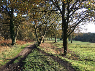
Berkhamsted to Tring via Toms Hill walk
Oct-20 • Saturdaywalker on Flickr
swcwalks swcwalk366 banner 50606176393

Berkhamsted to Tring via Toms Hill walk
Oct-20 • Saturdaywalker on Flickr
swcwalks swcwalk366 walkicon 50606918801


| Length |
15.79 km (9.81 miles) |
|---|---|
| Toughness |
3 out of 10 main walk, 6 out of 10 via Ivinghoe Beacon |
| OS Map |
Explorer 181, Landranger 165. Tring, map reference SP951122 is in Hertfordshire, 13 km (8 miles) east of Aylesbury. Berkhamsted, map reference SP993082, is also in Hertfordshire, 6 km (3.7 miles) south-east of Tring. |
| Features |
This walk takes a completely different route to the Book 2 Classic Tring to Berkhamsted. The start follows the Grand Union Canal, then you walk through ancient woodland and commons, passing chimneyed lodges and an impressive college building. You enjoy extensive Chiltern views, pass some trenches dug by World War I soldiers, to finish in Berkhamsted at a waterside pub. This walk is especially pleasant in late autumn when the beech trees in the Ashridge Estate display lovely leaf colour. |
| Walk Options |
Instead of the posted start you could opt for the start of the Book 2 Tring walk which takes you to Ivinghoe Beacon, then continue via Wards Hurst Farm to Little Gaddesden, to rejoin the posted walk at the lunchtime pub. This makes for a longer and more energetic walk of some 18 km (11.2 miles) overall. Or after the lunchtime pub you could double back to Tring via the Ashridge Estate. This makes for a shorter walk overall. After periods of heavy rain, when the canal tow path can become very muddy and /or flooded in places, and in July when the vegetation to the left of the tow path can encroach onto the path, making progress along it quite difficult, you might prefer to take the Alternative Start to this walk which follows the Hertfordshire Way north of the canal and south of the village of Aldbury, connecting up with the main walk route north of Tom's Hill and opposite Tom's Hill House. This alternative start reduces the overal length of the main walk by 2.4 km (1.5 miles). Directions are shown after the main walk. An Alternative Route starting in the Golden Valley to a gourmet pub for a late lunch option is shown after the Alternative Start in the Directions - this adds 1.86 km (1.16 miles) to the length of the walk. For those who enjoy canal-side walking, it is possible to stay on the canal towpath at Cowroast lock and continue beside the canal all the way to Berkhamsted, making for a relaxing 4 plus mile canal-side stroll. |
| History |
Tring: is a small market town with a population of 12,000 located within an area classified as being of Outstanding Natural Beauty, and some 30 miles north of Central London. There has been a settlement at Tring since prehistoric times and the market town is mentioned in the Domesday Book. Tring’s railway station is sited some two kilometres east of the town and regrettably you see nothing of the town on this walk. The Ashridge Estate: comprises some 5,000 acres of beech and oak woodland, commons and chalk downland. The varied landscape supports a rich variety of wildlife, with carpets of bluebells in spring, rare butterflies in summer and rutting fallow deer in autumn. The Estate is steeped in history, from iron age forts, Roman settlements, a Royal park, Capability Brown, both World Wars to its present day, now in the ownership of the National Trust (since 1926). Its most famous owner was Francis, 3rd Duke of Bridgewater. Known as the "Canal Duke", his pioneering work in the sector is commemorated in the Bridgewater Monument, erected in 1832. You can detour from the walk to the monument and climb it for a small fee from 1pm to 5pm April to October weekends and bank holidays for fine views over the countryside: ask in the tea kiosk opposite to get access if the tower is not open during these hours (it depends on how many volunteers the Trust has available on any given day). In 1759 Bridgewater employed engineer James Brindley to build a canal from Manchester to Worsley, Lancashire, one of his other estates, to transport coal from his mines there. Brindley's innovation - a technique called "puddling" - enabled the canal to travel in an aqueduct across the Irwell River valley. The aqueduct became the wonder of the age, and sparked a canal building boom that lasted till the advent of the railways in the 1830s. Bridgewater himself is buried in Little Gaddesden Church. Ashridge College (Ashridge Executive Education) is today a business school, part of the Hult International Business School with campuses in seven cities around the world. Ashridge is rated in the top ten business schools in the UK. The main building started life as a stately home built between 1808 and 1814 in the gothic revival style, one of the largest buildings in this style in the UK. Since 2020 the college has been home to an artisan cafe within its main building - the Bakehouse - see lunch options below. Berkhamsted is an historic market town in Hertfordshire, with a population today of some 18,500. The town’s main historic claim to fame is its link to the Norman Conquest in 1066. After the Battle of Hastings, the Anglo-Saxon leadership surrendered to the Norman encampment in Berkhamsted. During the 13th and 14th centuries the town thrived as a wool centre. It then went into decline and was only revived by the building of the canal. Berkhamsted was the childhood home of writer Graham Greene, whose father was the headmaster of Berkhamsted School. Berkhamsted Castle (tel 01375 858486), next to the railway station, is a classic Norman motte and bailey castle, built by Robert, Count of Mortain, the half-brother of William the Conqueror. Thomas a Becket, Henry II's chancellor and later martyred when archbishop of Canterbury, lived here from 1155 to 1165. There is not much to see, just a few ruined walls, but entrance is free, and if you have just missed a train at Berkhamsted, it is worth a quick look. The castle is open until 4pm in winter and 6pm in summer. Berkhamsted WW1 Troop Training Trenches in September 1914 the Inns of Court Officers’ Training Corps (nicknamed The Devil’s Own) set up a tented camp in Berkhamsted, close to the railway station, for officers’ training in preparation for action in the Great War. Over the next four years some 12,000 officers – some straight out of public school - trained in the camp and dug trenches on the nearby common to assimilate conditions in Flanders. Some 13 km of trenches were dug, and of these 500 metres remain and have been preserved thanks to the Chiltern’s Society. Today’s walk passes the trenches towards walk-end, and there is an interpretation board cum information plaque for visitor reference. Do spend a little while looking at this piece of recent history, and if you wish, walk in the trenches to the right of the path. Of the men trained, fifty percent were casualties of war with 2,200 killed in action. Three VC’s were awarded to the Devil’s Own, and on the golf course next to the Common is a simple stone obelisk as a memorial to the men. The oldest parts of Little Gaddesden Parish Church (The Church of St Peter and St Paul) date from the mid-thirteenth century although the church was substantially rebuilt in the 1870's. The interior is ornate with several memorials.The church is usually open for visitors and a visit is recommended. In its lovely, peacefull rural setting, some 600 metres east of the village pub, the church is the lunchtime picnic spot on this walk. Directions to it are given in the main Directions. Little Gaddesden Village Green War Memorial You pass this striking memorial a few minutes after your lunch stop in the village pub. This unusual brick and stone structure was built circa 1920 by Ashridge Estate’s bricklayers with the roof structure built by a local carpenter. The Memorial is in three sections – a central stone pediment under a pitched tiled roof with brick flanking walls on which the names of the fallen – 23 from WW1 and 6 from WW2 – are inscribed on stone tablets taken from Ashridge House. |
| Travel |
Take the train nearest to 10 am from London Euston to Tring, journey length from 40 to 52 minutes. There are four trains an hour from Berkhamsted back to Euston. Rail ticket: buy a day return to Tring. |
| Lunch |
Your pub lunch stop on the main walk route after 2.25 hours of walking is the Bridgewater Arms (tel 01442 842408) in the village of Little Gaddesden. Open seven days a week, the pub serves good value food from a varied menu, in comfortable internal dining areas and a very pleasant beer garden. Food is served all day weekdays from 12 noon until 9 pm, and at weekends from 10 am until 9 pm. Your second lunch option on the main route - some 30 minutes later in the walk after Little Gaddesden - is the Bakehouse artisan cafe within a single storey section of the main building at the front of Ashridge House. Open seven days a week from 08-30 am until 5 pm (and between 5 pm and 9 pm for dinner) this licensed cafe has a varied menu to cover most tastes and it makes for a very pleasant alternative to the Bridgewater Arms. In clement weather the tables and chairs outside the front of the Bakehouse come into play. Near the pub in Little Gaddesden is a village store, where provisions can be purchased for picnickers. A good picnic spot is the churchyard of the church in Little Gaddesden, some 600 metres or so from the pub. Your late lunch option on this walk for a gourmet lunch experience at the Alford Arms (tel 01442 864480) is shown in the Directions "Extension via Frithsden and The Alford Arms". This gastropub comes with a reputation, and SWC "foodies" should not be disappointed by the cusine on offer. Lunch is served (2025) Monday to Saturday from 12 noon until 3 pm, and all day on Sunday. Reservations, to avoid disappoinment, should be made ahead of your planned walk. Your eta for bookings is 2 pm (if you take a 10 am train from Euston). |
| Tea |
Just before the railway station you come to the Crystal Palace pub on the canal, which reopened in December 2021 following a major refurbishment after a lengthy period of closure. Head south-east along the canal towpath and in 300 metres you come to The Boat, a canalside pub with a pleasant outdoor verandah. Continue past the Boat along the canal and you soon come to The Rising Sun pub, popular with lovers of real ale. Back in the centre of Berkhamsted there are further pubs and a number of tea shops. Some of these tea shops stay open at tea time whilst others - annoyingly - close at 4 pm ie tea time ! One in the latter category is The Black Goo Cafe (tel 07596 224531) at 134 High Street, above the Home and Colonial Antique Shop (a steep climb up stairs). With branches also in Tring and Thame, this cafe is a very popular spot in town, open Monday to Saturday from 9.30 am to 4 pm, and on Sunday from 10 am to 4 pm. It's speciality is a "Blackgoo Dirty Tea " (don't ask). But even if SWC walkers make it in time before closing, they have to make it past the sign on the cafe counter - "No Riff Raff" - in order to get in !!. Finally, mention must be made of Berkhamsted Railway Station Cafe which, in addition to serving hot drinks, doubles up as a wine shop, with an excellent choice of red wines, and white wines in a tall fridge - perfect for SWC walkers who like to purchase "supplies" to enjoy on their train journey home. |
| Profile | |
|---|---|
| Help Us! |
After the walk, please leave a comment, it really helps. Thanks! You can also upload photos to the SWC Group on Flickr (upload your photos) and videos to Youtube. This walk's tags are: |
| By Train |
Out (not a train station) Back (not a train station) |
| By Car |
Start Map Directions Return to the start: Finish Map Directions Travel to the start: |
| Amazon | |
| Help |
National Rail: 03457 48 49 50 • Traveline (bus times): 0871 200 22 33 (12p/min) • TFL (London) : 0343 222 1234 |
| Version | |
| Copyright | © Saturday Walkers Club. All Rights Reserved. No commercial use. No copying. No derivatives. Free with attribution for one time non-commercial use only. www.walkingclub.org.uk/site/license.shtml |

Walk Directions
- Arriving at Tring Railway Station go up the steps and at the top of the gantry turn left to exit the station at its main, north-western exit. But Note if you are taking the Alternative Start, you turn right at the top of the gantry steps, to follow the Directions after the Main Directions.
- The main route continues: Turn left along the road, in a south-westerly direction, passing the Posting House on your left-hand side. In 240 metres, cross the road just before the road swings to the left by a road bridge, and in the entrance to Wolds Farm, take the flight of signed steps down to the Grand Union Canal.
- At the bottom of the canal steps, turn left on the towpath to head back under the bridge, to start a relaxing canal-side walk. The towpath is quite narrow in places so it is single file for walkers. In summer sections of the towpath can become overgrown, so take care. In 1,200 metres you pass under the brick road bridge No 136 and continue along the canal. In a further 440 metres cross a hump-back bridge with a sign “Welcome to Cowroast Marina” and keep ahead along the canal.
- In 280 metres you come to Cowroast Lock . Leave the towpath by the path up to the road bridge and turn left , in 30 metres passing the entrance to Cowroast Marina on your left-hand side. You are now on a country lane which swings to the right . In 140 metres [!] look out for a footpath sign on the left and turn into a field, your direction 60°. You are now on the Chiltern Way.
- In 100 metres cross the main-line railway on footbridge No 109 and at its far side continue through the next field. In 70 metres go through the field-end boundary hedge and by a footpath post turn right onto a footpath. In 60 metres at a path T-junction, turn left uphill on a car-wide grassy track heading towards Norcott Court Farm .
- Go to the right of a metal field gate (when not propped open) and after 65 metres continue uphill past the farm buildings on the farm access road. In a further 40 metres you come to a farm-track T-junction. Here turn left for 5 metres then turn right with a footpath marker post to cross a gravel way. In 20 metres go through a wooden swing gate with a yellow arrow and in another 20 metres a second one in a fence line and bear diagonally left , up a grassy field, your direction 340°. There are often llamas or alpacas in this field and the adjacent field to its right, and they don’t seem to mind visitors.
- In 360 metres at the top left-hand corner of the field go through a wooden swing gate and pass by a metal barrier, and in 8 metres you come out into a field. Now keep ahead skirting the top edge of a field, your initial direction 340°. Follow an undulating way, down a dip and up the other side. In 215 metres your way enters a woodland strip directly ahead of you, by a yellow arrow on a post. Head up to a metal swing gate which you pass through to then head half-left, diagonally up another grassy field, your direction 325°.
- In 200 metres at the top of the field, beside the edge of woods, pass through a metal swing gate, head down and swing right towards a wooden fieldgate, by a four-arm footpath sign (the fourth arm, pointing in the direction you are to take, is missing) enter woods, your direction 45°. You are now going to ascend Tom's Hill on a pleasant way through woodland.
- In 300 metres as you near the top of the hill go through a wooden fieldgate and keep ahead, in 35 metres coming out into the open as a track cum drive joins from the right. In a further 85 metres go through a metal fieldgate into a private car parking area, with buildings over to your right.
- In 80 metres you exit the car park to go past the Old Stables and Tom's Hill then Rose cottage on your left and Stable cottage on your right, and bear left to continue now along a tarmac drive, initially with a high red brick wall on your right-hand side. You pass the entrance to Tom's Hill House to your right - the Alternative Start rejoins the main walk here on your left-hand side. Soon the drive takes you through light woodland. Ignore all signed ways off to your right.
- In 340 metres the drive joins a public road at a sharp bend in the road. [!] Turn right and head along the road’s left-hand earthen verge, uphill for 50 metres until you come on your left to an access drive into the National Trust’s Ashridge Estate . Turn left and head along the gravel drive through woodland and in 295 metres go through a wooden swing gate to the left of a wooden fieldgate to pass on your left-hand side Old Copse Lodge .
- Continue ahead past the lodge on what is now an earthen track, through light woodland, where there is evidence of recent cherry laurel and rhododendron invasive removal. Ignore ways off and in 480 metres cross over “Five Cross Junction” and keep ahead. In a further 500 metres you reach Thunderdell cottages on your right-hand side and come out onto a small – but busy - public road, which you cross over with care to enter the Ashridge Estate .
- You pass on your left-hand side the attractive chequered Thunderdell Lodge , with its stone walled garden. Some 10 metres beyond the end of the garden wall [!] you leave the estate road and bear left by a footpath post into woodland.
- Follow the meandering woodland path for some 210 metres until you come out at a T-junction with the broad Princes Riding path. Here you can look left and see the Bridgewater Monument and look right to see the outline of Ashridge Hult College which you will be exploring in the afternoon.
- Directly behind Princes Riding path (ahead of you) is a golf course. Note There is a public footpath which crosses diagonally right across the fairway ahead of you, which you could take, but from time to time the golf course managers put up notices asking you to take an easy, convenient diversion which does not interrupt play. We will take this diversion as follows.
- Turn right along Princes Riding path. In 170 metres you come to a tarmac cross path. Turn left onto this path and keep ahead, with a golf green on your left. You are now on the access drive to Old Park Lodge.
- You pass on your left the red brick Old Park Lodge , an unusual lodge with a sundial on its front elevation. Cross over grass then an earth track and look out ahead for a footpath marker post with a blue-and-white "Pedestrian Route" sign, which directs you past and alongside a barn on your left then downhill through light woodland, in 100 metres coming out onto a golf course. Directly ahead of you is the large clubhouse, the 19th hole.
- Follow directional signs and yellow topped markers down over a fairway then uphill, passing to the left of the clubhouse. You keep ahead , skirting woods until you come out onto a tarmac access road. Pass a timber clad building on your right and keep ahead along the road. In 200 metres at a road T-junction, cross over , then a grassy verge and at a footpath sign to your right [!] take the hedged alleyway between two houses, gently downhill.
- In 150 metres leave the alleyway and continue ahead through light woodland. In 90 metres cross a golf T immediately to your right and in 40 metres re-enter light woodland, to head downhill to a dip, and in 70 metres enter a fenced-in path. Note on your right the attractive period house with tall chimneys. Continue down then up this path which comes out onto a main path at a T-junction. Now head up some wooden steps to another enclosed path ahead and slightly to your left. In 150 metres this path comes out into the car park for the Bridgewater Arms, your lunchtime pub, which is directly opposite.
- Picnickers - Route to The Church of St Peter and St Paul : Turn right in front of the Bridgewater Arms pub and at the end of the pub's beer garden at a 3-arm metal footpath sign, turn left through a wooden kissing gate. Keep ahead on a path between wooden post and rail fences.
In 70 metres ignore a turning to your right and keep ahead. In a further 125 metres the path swings to the left and in 20 metres go through a wooden kissing gate. Keep ahead, slightly right, over a grassy paddock on a clear path which swings to the right, in 100 metres to exit the paddock through a wooden kissing gate.
Turn left onto a tarmac access road and in 160 metres you arrive at the Church. You will find a number of wooden benches in various parts of the peaceful churchyard, and one outside the front boundary walls.
After your picnic and visit to the Church, return down the tarmac access road, passing on your right the kissing gate which took you out onto this road on your outward walk. Keep ahead down this access road.
In 325 metres you have school playing fields to your left, and Little Gaddesden Village Hall, then Little Gaddesden C of E Primary School to your right. In a further 100 metres you come out to the main road through the village, with the War Memorial over to your left and your onward route (main walk) ahead of you, slightly left. Head down this lane and from here follow the main walk directions below. - Head down the road. You pass village houses and in 220 metres you come to a road junction with an unusual, but tasteful, War Memorial on your left-hand side. Immediately opposite this memorial is a stone memorial cross with stone seating. Head down the tarmac lane to the right of the memorial cross, signed “Ashridge House - Private Road - Access Only" and it is signposted public footpath. You can if you wish walk along the soft verge to the left of this lane. In 60 metres you bear left with the lane,ignoring the right turn (Ringshall Drive).
- In 260 metres continue ahead at the first sign saying Ramp. In another 100 metres the waymarked Ashridge Estate Boundary Trail (AEBT) joins from the right and you can follow a clear grass path to the left of the lane from here. In a further 200 metres you come to the second sign saying Ramp on your right-hand side. Now head down the attractive grassy Golden Valley. Keep ahead through the valley, passing a bench to the left, until in 300 metres you come to a minor, but clear, cross paths. [!]. The path to your left heads down from a steep hillside (there is another bench half-way up this hillside). The path to your right heads steadily up a grassy hillside. [!] You take the grassy path on your right and at the top of the incline you re-join the tarmac lane, close to the entrance to Ashridge House, now an international business school Unless you want to follow the Alternative Route - Extension via Frithsden and The Alford Arms - in which case you stay in the Golden Valley - See the Directions after the Alternatve Start Directions.
- Head up the lane towards the House and go through the entrance gate as if you were planning to have lunch in the Bakehouse artisan cafe (as advertised on the entrance gate). Now walk along the road in front of the House and in a little over 100 metres you come to an entrance in the period building's frontage giving access to the cafe and courtyard beyond. Keep ahead along the access road as you head for a small wooden security lodge at the exit road to the college.
- Just before you reach this security lodge leave the access road and head diagonally, left over grass to join a public footpath along a hedge. Keep ahead along the hedge and at its end turn left to follow the footpath which skirts the newer college buildings to your left, with woodland to your right, your direction 150°. There is a footpath marker post here (leaning precariously) with a faded arrow - the green metal high level footpath sign is missing (since January 2024). Head down this path and in 500 metres you come to the end of the college buildings on your left. The path continues downhill, now with woodland on both sides, and in a further 210 metres you come down to a valley public road.
- Turn left along the valley road. In 160 metres you pass on your right Berkhamsted Lodge. In a further 110 metres you pass on your left the entrance to Birch House. Here on your right is a small gravel car parking area. [!] Turn right into this area, ignore the footpath to your right and instead take the path left , uphill, to pass to the left of a pair of old prominent conifers and in a few metres at the path junction [!] turn right uphill around the back of the conifers. In 80 metres at a path junction turn left . Your way meanders through scrub and undergrowth and in 65 metres at the next wider junction turn left and head down to enter a field.
- Take the path straight ahead up this grassy field, to the left of some trees ahead. At these trees go over crosspaths and continue ahead over grass, on a path on the level, your direction 145°, aiming for the treeline ahead. In some 325 metres and just before you reach the treeline the path comes out onto a stony track. Turn right along this track and within 100 metres bear left and head into the woods ahead of you. In 50 metres you come on your left to a National Trust sign for Frithsden Beeches .
- Continue straight ahead along this earthen track which soon narrows to a woodland path. In 230 metres at a dip go over a crosspaths. In a further 280 metres go over another crosspaths. In 75 metres at a third crosspaths by a post with multiple arrows [!] turn left into Berkhamsted Common .
- Keep ahead, gently downhill, soon with fine views to your right of the town of Berkhamsted. Amongst the sights is a white tower on the distant skyline. On Google someone says it looks like Rapunzel should be in residence! – but it is actually a water tower.
- Some 460 metres along this path you come to a bench and information panel on your right-hand side. This explains that the odd shapes in the ground here are the remains of trenches dug by officers’ practising trench warfare in World War One. It is worth spending a little while exploring this fascinating piece of history. Try walking in the trenches.
- Some 135 metres beyond the trench information panel the path forks at a footpath post [!] and you take the smaller path to the right , your initial direction due south. This woodland path heads downhill to a dip at a cross paths then, uphill, coming out to a public road. Cross over and continue on the bridleway directly opposite.
- Keep ahead on this bridleway, ignoring ways off, uphill and within the right-hand edge of a wood until in 190 metres you come to a house directly ahead. Here turn sharp right by a signpost for Berkhamstead station 1 mile and walk along a broad, grassy ridge path with more extensive views to your right on your approach to Berkhamsted .
- In 350 metres you come to a three-arm signed footpath descending diagonally on your right, down the hillside between new post and wire mesh fencing on either side. You can if you wish take this path down to the public road (New Road) where you turn left - but the recommended route is as follows.
- Keep ahead on the ridge path with a hedge on your left and a new post and wire mesh fence on your right. In 200 metres our previous route which headed diagonally right down the hillside is now blocked by the post and wire mesh fence on your right-hand side. So instead keep ahead on the ridge path, now with houses to your left. In 180 metres go down a dip and head up the other side. In a further 80 metres at the end of the path, turn sharp right to head down a broad earth and gravel path, with the post and wire mesh fence on your right and a hedge then fences on your left.
- In 150 metres ignore new metal fieldgates to your left and right, and continue down the broad path for a further 100 metres where you exit onto New Road.
- Turn left along the road which in 220 metres swings to the right to descend to a three-way road junction. For the direct route to the railway station, take the third exit on your right (almost directly ahead of you). In 210 metres you cross a main road - Berkhamsted railway station is directly ahead of you (its northern entrance).
- For the walk-end pubs bear left at the road junction to go under a railway bridge. Immediately ahead of you is the Crystal Palace pub on the canal. For the other two canal-side pubs, keep ahead past the Crystal Palace pub for a few metres and you come to The Grand Union Canal . Turn left along its towpath for 300 metres, and you come to Ravens Lane Lock (No 34) with the The Boat pub just beyond it. A little further along the canal you come to The Rising Sun pub which specialises in real ale.
- After visiting one of these pubs return along the towpath to the Crystal Palace pub, and then with the pub on your right keep ahead on Station Road. Within 200 metres you come to Berkhamsted Railway Station on your right-hand side (its southern entrance). Inside the station foyer on your right-hand side you have the Station Cafe , for hot drinks and "supplies". Go to platform 4 for your train journey back to London.
Alternative Start
- Leave Tring Railway Station by its North East exit, viz at the top of the 31 steps to the gantry turn right . At the end of the gantry turn left and take the ramp down to the car park. Keep ahead, with the car park to your right, and in 20 metres exit the railway premises out onto a public road (Station Road).
- Turn right along the road. In 40 metres turn right off the road to pass through a metal swing gate. Take the earthen path to your left, initially parallel to Station Road to your left. But Note : if this path looks muddy after periods of heavy rain, you can stay on Station Road until the road takes a sharp turn to the left - see below.
- Cross over a concrete access track and keep ahead, with open fields to your right. You next pass the entrance over to your left to the route which leads to Ivinghoe Beacon. The path and road to your left now swing to the right. Some 450 metres from the entrance to the route to the Beacon, the road swings sharply (90°) to the left. Go through the field boundary, and with a 3-armed metal footpath sign some 8 metres over to your left, keep ahead , your direction 140°, with a hedge to your left and vast open fields to your right.
- In some 300 metres the path starts to swing to the left in a long radial curve. 60 metres from the end of the curve cross a private horse gallops. In a further 65 metres go over a path crossing and keep ahead between posts with arrows, on a path with hedges on both sides.
- In 90 metres cross over a tarmac road with a metal footpath sign to your right to follow in the direction "Public Highway to Tom's Hill". Head up the gravel driveway to "Brightwood", a large detached house to your right. When the drive becomes an earthen track, you pass "Brightwood Cottage", again on your right. You now have a section of 2.5 metre high brick wall to your right.
- At the end of the wall keep ahead, gently uphill, go over a low metal barrier to enter a path in a woodland strip, which soon swings to the right. At a 3-arm footpath sign keep ahead (slightly right), to pass between woooden gate wingwalls (gate missing), now in light woodland. Keep ahead, initially gently then steadily as you climb through light woodland. In some 400 metres, as the path begins to level out, you come out onto a tarmac drive, with Tom's Hill House ahead of you, slightly to your right. Now rejoin the main walk directions by turning left onto the drive.
Alternative Route - Extension via Frithsden and the Alford Arms
- Continue ahead along the valley bottom and in 150 metres a path joins from up on the left through a metal gate and in 370 metres by a marker post, you continue along a gravel track joining from the right behind. In 30 metres curve to the right across grass and on the level, where the track veers left up into a wood. Continue with the AEBT, keeping the wood on your left, ignoring a marked public footpath forking right up the grassy slope. In 200 metres go over a stile to the right of a double wooden field gate. You curve to the left with the path and in 430 metres from the stile walk between a small clump of trees on the left and a lone dead tree on the right, now with a barbed wire fence on the left. In 90 metres at the fence corner, you continue ahead along the valley bottom and in another 370 metres at a fence this side of a large arable field, turn up to the right along the fence with an AEBT marker on a fence post.
At the fence corner near the top of the rise, turn left along the fence, now with fine views down and across the valley, as well as to an interestingly sculpted hedge in a garden away to the right. In 180 metres enter Webb's Copse through a wooden kissing gate and follow a clear meandering path through it. You leave the wood in 280 metres in its far left corner and continue along a left hand arable field boundary. In 600 metres go over a stile in a fence line into a large pasture and follow its right hand upper boundary. In 450 metres go through a metal kissing gate to the right of a wooden field gate and in 20 metres turn right through another metal kissing gate to the left of a metal car gate and follow a fenced path to the left of a farmyard. In 40 metres you emerge into an arable field and follow its left hand grassy boundary downhill, with fine views across the dry valley to Great and Little Frithsden Copses. In 180 metres in the bottom field corner follow a footpath to the left of a garden fence and in 60 metres turn left along a tarmac lane (leaving the AEBT). In 300 metres fork to the right of a small triangular green to the far side of the green where you find The Alford Arms.
Turn right off the lane up along a signposted footpath (also signed as a permissive bridleway) up an initially stepped path into Little Frithsden Copse. Ignore metal field gates on both sides where the gradient eases (fine views into the valley on the left, as well as some views into another one on the right). Eventually you continue to the left of some fenced gardens and then ignore an unmarked public footpath turning left through a wooden kissing gate by a meadow on the left. In 50 metres cross a tarmac lane by a multi-directional signpost on the left and continue through a bike barrier and between hedges. In 110 metres go through another bike barrier into a wood and ignore a marked bridleway to the left but in 30 metres turn left at a T-junction of forest tracks with a marked bridleway. In 50m, just before a road, turn hard right back on yourself with a two-way bridleway signpost, gently uphill.
In 150 metres you emerge in a clearing by a first warning sign for golf balls and follow the well-marked path (yellow-topped bridleway posts) across a couple of fairways and through some belts of trees. Eventually you pass to the left of a War Memorial and emerge by a three-way road junction. Cross into a car park a little to the right and bear left along its left hand edge with a bridleway signpost, ignoring another signpost away to the right. Pick up a gravel path between trees parallel to the audible road on the left. Ignore a right turn at a four-way signpost to the WWI trenches and also cross a gravel track by a two-way bridleway signpost to continue downhill. In 160 metres you reach a four-way junction by a another WWI trenches signpost. Turn left uphill with Public Bridleway 57 to a public road. Cross over and continue on the bridleway directly opposite. Pick up the directions to the main walk in paragraph 31.