Tunbridge Wells Circular walk
A varied High Weald walk with stretches through parkland, restored heathland and woods containing massive sandstone outcrops, finishing alongside the Spa Valley Railway.

DSCF7335
Old Well and High Street, Frant
Apr-11 • Sean O'Neill
swcwalk19, swcwalks, walkicon 5599908383683936674 P

DSCF7482
Climbers at Harrison's Rocks
Apr-11 • Sean O'Neill
swcwalk120, swcwalk19, swcwalks, walkicon 5615190850250775202 P

DSCF7482
Climbers at Harrison's Rocks
Apr-11 • Sean O'Neill
swcwalk120, swcwalk19, swcwalks, walkicon 5599910009218429218 P

CIMG9045
The Nevill Crest at the golf club
Oct-13 • Sean O'Neill
swcwalk19, swcwalk196, swcwalks, walkicon 5963245667981105490 P

CIMG9045
The Nevill Crest at the golf club
Oct-13 • Sean O'Neill
swcwalk19, swcwalk196, swcwalks, walkicon 5953964414343486082 P

CIMG0750
Bluebells in Forge Wood
Apr-14 • Sean O'Neill
swcwalk19, swcwalks, walkicon 6005105484915761266 P
| Length |
Main Walk: 23¾ km† (14.8 miles). Five hours 50 minutes walking time. For the whole excursion including trains, sights and meals, allow at least 11 hours. Alternative Walk, starting from Frant: 21¼ km† (13.2 miles). Five hours 15 minutes walking time. † Subtract 4¼ km (2.6 miles; 1 hour 5 minutes) with shorter afternoon. See Walk Options below. |
|---|---|
| OS Maps |
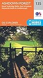
Explorer 135 & (if starting from Frant station) 136. Tunbridge Wells, map reference TQ585392, is in Kent, 7 km S of Tonbridge. |
| Toughness |
6 out of 10 (5 with shorter afternoon). |
| Features |
This walk through the High Weald near the border of East Sussex and Kent has plenty of interest and variety. After escaping from the suburban charms of Tunbridge Wells you climb through woodland to a possible early lunch stop in the elegant hill-top village of Frant, dominated by its large triangular green. The walk continues with an attractive but potentially muddy stretch through the landscaped parkland of the Nevill Estate's Eridge Old Park, where Forge Wood has a fine display of bluebells in spring. After the suggested lunch stop in the hamlet of Eridge Green the route passes Eridge Rocks, the first of three impressive sandstone outcrops which are a distinctive feature of the High Weald. The walk continues along the southern edge of Broadwater Warren nature reserve (free entry), once a gloomy conifer forest which is gradually being restored to heathland and woodland by the RSPB. A loop around Harrison's Rocks (where you can usually watch climbers practising their skills) brings you to a possible mid-afternoon refreshment stop in the village of Groombridge. The final section is along the Grom valley and follows the route of the Spa Valley Railway (SVR), a restored branch line. You pass the grounds of Groombridge Place, a beautiful Jacobean manor house surrounded by a medieval moat, and glimpse yet another outcrop at High Rocks. The route into Tunbridge Wells goes across its large wooded common into The Pantiles, a famous colonnaded walkway with interesting shops, galleries, cafés and (sometimes) market stalls. The spa town developed in the 17thC after an influential nobleman staying nearby became convinced that the iron-rich water from its chalybeate spring had curative properties. Its popularity waned in the 18thC when sea bathing became more fashionable than ‘taking the waters’, but revived after regular visits from Queen Victoria and Prince Albert. The town's popularity with the royal family led to it being granted the “Royal” prefix in 1909. The soils in the High Weald do not drain well and you will need to be prepared for muddy or waterlogged paths after wet weather. |
| Walk Options |
The original version of this walk started at a rural station one stop down the line from Tunbridge Wells, called Frant but some way from its village. This has been relegated to the Alternative Walk option as its first 300m is a less-than-ideal stretch along a busy narrow road with no pavement, but it might allow you to take a later train and catch up a group which started from Tunbridge Wells. At the point where you leave Broadwater Warren there are three onward routes: the full route via Harrison's Rocks and Groombridge, a short cut omitting the loop around the rocks, or the shorter afternoon which bypasses both the rocks and Groombridge. Another option for shortening the walk would be to take a ride on the heritage railway from Groombridge (or High Rocks) into the old Tunbridge Wells West station, leaving just a 1¼ km stroll via The Pantiles to the mainline station. More prosaically you could take Metrobus 291 into Tunbridge Wells (details below). |
| Additional Notes |
There used to be a choice of routes out of Tunbridge Wells, but the longer one was dropped as a new housing development along the route made it rather less appealing. At the same time the other route was modified to reduce the out-and-back overlap along the High Street. The Main Walk used to take a more direct route from Eridge Rocks to High Rocks, utilising some permissive horse rides in Broadwater Forest (with the route via Groombridge designated as the Long Walk). However, the horse ride opposite the RSPB's car park was blocked off in 2023, presumably to prevent the establishment of a right of way. This route had the advantage of a longer exploration of Broadwater Warren but will only be restored if these rides are reopened to the public. |
| Transport |
There are up to four trains an hour from Charing Cross to Tunbridge Wells, taking about 55 minutes; fewer on Sundays and in the evenings. Frant is the next station on the same line but it only has an hourly off-peak service, taking 1 hour. A return to Tunbridge Wells is sufficient for the Main Walk, but a slightly more expensive return to Frant would let you start from either station. Tunbridge Wells is a major transport hub with a good bus service, making it possible to start or finish this walk at several points along the route. Several Stagecoach services go through Frant village, and along the A26 to Eridge Green there is an hourly service on Brighton & Hove 29. Finally, Metrobus 291 goes through Groombridge (hourly Mon–Sat, two-hourly Sun & BH). If driving, parking anywhere near the centre of Tunbridge Wells is difficult and/or relatively expensive. The station car park is not large and costs £7.60 Mon–Fri, £5.70 Sat, £3.50 Sun & BH. At Frant the cost is £4.60 Mon–Fri, £3.50 weekends & BH (2023). |
| Suggested Train |
Take the train nearest to 09:45 from Charing Cross to Tunbridge Wells (or 10:15 if starting from Frant). If you plan to stop in Frant village for an early pub lunch, take the train an hour later. |
| Train Times |
|
| Timetables |
|
| Lunch |
The suggested lunch stop (after 10 km from Tunbridge Wells; 7½ km from Frant) is the Nevill Crest and Gun (01892-864209) in Eridge Green, which has a large garden and serves good food all day from noon. If you start late and want an earlier lunch stop, the George Inn (01892-750350) in Frant village also has a beer garden and serves good home-made food, up to 2.30pm daily. |
| Tea |
At the end of the walk there are many refreshment places in Tunbridge Wells. The cafés in The Pantiles have outdoor seating in fine weather, and some of the restaurants and winebars here also serve cream teas. There are more cafés, delicatessens and coffee shops on the way to the station along the High Street, such as Juliets at #54 (01892-522931; open Tue–Fri & Sun to 4pm; Sat to 5pm). There are also plenty of pubs in the town, with the most unusual being the Opera House, a splendid building which more recently was a cinema and bingo hall and is now a JD Wetherspoon pub; it is a five-minute walk up Mount Pleasant Road from the station. If you don't expect to reach Tunbridge Wells in time for its tea places, the High Rocks Inn (01892-515532; closed Mon & Tue) has a large garden next to the SVR station. On the full walk you might also be able to get some mid-afternoon refreshment in Groombridge: when the SVR is operating there is a buffet on the station platform, and the route also passes the Junction Inn (01892-864275; closed Mon & Tue). |
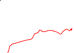
| Profile | |
|---|---|
| Help Us! |
After the walk, please leave a comment, it really helps. Thanks! You can also upload photos to the SWC Group on Flickr (upload your photos) and videos to Youtube. This walk's tags are: |
| By Train |
Out (not a train station) Back (not a train station) |
| By Car |
Start TN1 1BT Map Directions |
| Amazon | |
| Help |
National Rail: 03457 48 49 50 • Traveline (bus times): 0871 200 22 33 (12p/min) • TFL (London) : 0343 222 1234 |
| Version |
Apr-24 Sean |
| Copyright | © Saturday Walkers Club. All Rights Reserved. No commercial use. No copying. No derivatives. Free with attribution for one time non-commercial use only. www.walkingclub.org.uk/site/license.shtml |


Walk Directions
Click the heading below to show/hide the walk route for the selected option(s).
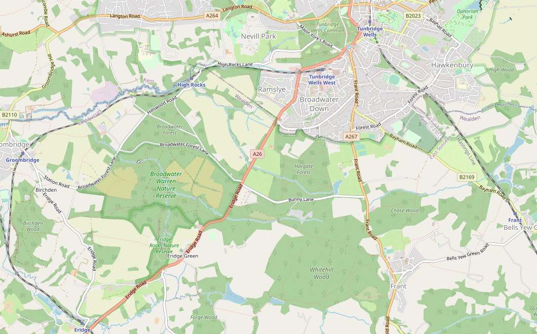


 Walk Map
©
Walk Options ( Main | Alt. )
Click on any option to show only the sections making up that route, or the heading above to show all sections.
- Main Walk (23¾ km)
Walk Directions
Click on any section heading to switch between detailed directions and an outline, or the heading above to switch all sections.
If you are doing the Alternative Walk (from Frant station), start at §C.
If you take a bus to Frant (Abergavenny Arms), head south on the A267 and pick up the directions in §D.
If you take a bus to Eridge Green (church), start at §E.
- Tunbridge Wells Station to Forest Road (2 km)
- Leave the station by the Mount Pleasant Road exit. Cross the main road and take the short street off to the left into Calverley Grounds. Unless you want to explore the gardens more fully, go up its right-hand side and leave via Mountfield Gardens. Cross over Grove Hill Road into Sutherland Road and continue across The Grove to its far left-hand corner. Keep ahead on Claremont Road. After it bends left turn right onto a footpath going alongside the grounds of Claremont Primary School. At the end bear right onto the continuation of the footpath, a long alleyway (The Chase). At the end cross a road and enter Farmcombe Road Open Space. Go across it to an exit near its top left-hand corner.
- Trains can arrive on either platform. From Platform 2, go up steps to the Mount Pleasant Road exit. You can reach this exit from Platform 1 via the overhead walkway, but you can also go out through the ticket office, turn right and take a path up steps and over the railway to Mount Pleasant Road.
- Either way, cross the main road carefully and go along a short street with a sign for Great Hall parking (about 50m to the left of the Mount Pleasant Road exit; almost opposite the path from the ticket office). Keep to the left of the car park entrance to enter Calverley Grounds?.
-
Unless you want to explore them more fully, fork right inside the gardens and follow the path up its right-hand side, curving round to the left. Where the path veers away from the edge turn sharp right to go out onto a residential street (Mountfield Gardens).
- For a small detour you could go straight ahead from the main entrance, passing the Tea House? café. Continue through the small Sunken Garden, go up steps on the right and turn right at the top to reach the Mountfield Gardens exit from the other direction.
- Go down Mountfield Gardens to its junction with Grove Hill Road. Cross over into Meadowhill Road (just off to the right), which leads into The Grove?. Bear left to go along the top edge of this open space, dotted with trees. After passing a children's playground veer left onto a short path leading out to Claremont Road.
- Keep ahead on this road, crossing Buckingham Road and several more side streets. Shortly after the road has curved round to the left turn right onto a signposted footpath, a tree-lined alleyway alongside the grounds of a primary school. At the far end ignore the signposted byway opposite and bear right across the school's access road onto the continuation of the footpath.
- This long alleyway (The Chase) goes between the school playing fields and garden fences. It eventually comes out onto a patch of grass alongside Farmcombe Road. Carry on alongside the road for a short distance, but before its T-junction with Forest Road cross over and go through a small metal gate into Farmcombe Road Open Space.
- Make your way across the grass towards the left-end of a belt of trees across the recreation ground, about 150m away. Go through a gap in these trees and leave through a wooden gate on the left, going up a few steps onto Forest Road.
- Forest Road to Frant village (3¼ km)
- Turn right onto Forest Road, then in 100m take a footpath on the left. At the end turn left and go along Benhall Mill Road for 400m to the entrance to Nevill Golf Club. Take the footpath heading south along the edge of the golf course, signposted as the HWLT and TWCW. Follow this waymarked trail across Bayham Road, past Brickhouse Farm and up through Chase Wood into Frant.
- Turn right and go along Forest Road for 125m, crossing over carefully at some point. Before reaching the Warwick Park bus stop turn left onto a track between houses, signposted as a footpath. In 60m fork right off the main track onto a path through a strip of woodland, soon going between wooden barriers.
- The woodland path eventually goes alongside some new houses, bends right and comes out onto a minor road (Benhall Mill Road). Turn left and go along this road, passing the new Regency Grange housing estate on the left. In 400m you reach the entrance to Nevill Golf Club on the right, with the Nevill Crest? on top of each of the brick pillars.
- Take the signposted footpath to Frant to the right of the Golf Club entrance, joining both the Tunbridge Wells Circular Walk? (TWCW) and the High Weald Landscape Trail? (HWLT). Go all the way alongside the brick wall on your right; past the car park and club house, then downhill past a practice area.
- At the bottom go through a wicket gate, cross the B2179 carefully and continue on the long farm drive opposite. At Brickhouse Farm go past some buildings and along the right-hand edge of the farmyard. On the far side turn left as indicated onto a farm track, then in 25m turn right onto a tree-lined enclosed path between fields.
- In 200m follow the path into Chase Wood, crossing a stream on a wooden footbridge. In 100m fork left in front of a small open area, then keep left at the next path junction to join a wider path. Stay on this broad path as it crosses another stream and makes a long steady climb through the wood, soon curving right to head SW.
- Eventually you go through a wicket gate into the bottom corner of a large field. Take a grassy path up its left-hand edge, in 100m crossing over a track where there is a wide gap in the hedge on your left. A little further on go through a smaller gap in the trees to continue up the left-hand edge of a second field. In the top corner go over a stile into a churchyard.
- Follow the path round to the front of St Alban? (which is worth visiting). Go out through its lychgate and keep ahead along Frant's picturesque High Street. The George Inn (the early lunch pub) is the first building on the left, opposite the Old School?. Where the road forks continue along the top of a small triangular green to the site of an old well.
- Frant Station to Frant village (2¾ km)
- There is a choice of routes at the start. For the main route, turn left out of the station and go along the B2169 for 300m, then turn left onto a footpath going up a track between fields to a lane. You can avoid the awkward stretch along the busy B2169 by turning right out of the station, then right again in the centre of Bells Yew Green onto this quiet lane. Either way, instead of taking the lane all the way into Frant, turn left into the driveway to Manor Farm and take a footpath across fields to the village.
-
Main route
- Leave the station through its car park and turn left onto the B2169. After the pavement ends you will need to take great care, especially where the road curves left under a railway bridge. On the other side turn left onto the access road for a new development (Paddock View), which is also a public footpath.
- After passing the houses continue on a track climbing gradually between fields towards some buildings on the horizon, veering right and then left halfway up the hill. At the top keep ahead across a yard and pass to the right of a large corrugated iron shed.
- Go across a concrete track (slightly to the right) and over a stile to continue on a rather gloomy enclosed path. Where the way ahead is barred by a gate with a “Private Property” sign, go over a stile on the left onto a narrow path between hedges. At the end turn right onto a minor road, joining the alternative route.
-
Alternative route
- Leave the station through its car park and turn right onto the B2169. In 250m you pass the Brecknock Arms and come to a crossroads in the centre of Bells Yew Green?. Turn right at the junction, signposted to Frant and soon crossing over the railway.
- In 400m ignore a bridleway on the left as the lane bends right. Continue along the lane for a further 500m, round several more bends. Eventually a footpath comes in from a gap in the hedge on the right, the main route.
- After passing Brynderi Cottage turn left through the solid brick and stone gateway to Manor Farm, with a concrete footpath marker. In 300m, where the driveway turns slightly away from the hedge on the right, keep ahead across a patch of grass towards a metal fieldgate in the hedge.
- Go through a wooden gate to the right of the fieldgate onto a path across a large field, heading W towards a prominent half-timbered building in the distance (Inchbroom House). After passing a few isolated trees the path bears slightly right and comes to a gate on the far side of the field.
- Go through the gate and follow the path across a second field, again curving slightly to the right. Another gate on the far side takes you onto a grassy path through a sloping meadow, gradually approaching the road you were on earlier. Go though a side gate beside a double fieldgate and turn left onto the road, taking care as there is no pavement.
- In 150m the road forks in front of a small triangular green. Climb up the grass between the two roads to the site of an old well at the top. Unless you want to visit the village pub or church (150m away to the right, at the far end of the picturesque High Street) turn left at the well, joining both the Tunbridge Wells Circular Walk? (TWCW) and the High Weald Landscape Trail? (HWLT).
- Frant village to Eridge Green (4½ km)
- Head south across Frant's large green on the HWLT/TWCW. Keep ahead along the A267, then turn right to go between a large wood and Eridge Old Park. After skirting a lake continue over a small hill with a distant view of Eridge Park mansion beyond another large lake. Go through Forge Wood and uphill around field edges to the A26.
- From the old well head S along the top of the small green, cross a minor road and climb up onto Frant's main green. Follow a path down the large sloping green, with another minor road on your left and the A267 down to your right. You will end up heading S on the other side of the main road, but you can first cross the minor road and continue on another part of the green.
- About 175m beyond the main green turn right down a narrow path between “Thornbury” and a small telephone exchange, still on the HWLT & TWCW. Follow the enclosed path downhill and turn left in front of a deer fence at the bottom. Almost immediately turn right through a gate in this fence to enter Eridge Old Park?. Head W through the parkland along a pleasant grassy path.
- In 350m go through a kissing gate into a more wooded area and follow the path to the left. Continue on this tree-lined path at the edge of the wood for 500m, ignoring a permissive path off to the right along the way. Where the path comes to a fence, with a metal fieldgate on the left and a wood ahead, turn right down a slope and across a stream.
- Follow this potentially very muddy broad track alongside the wood, detouring through the semi-cleared area on your right if necessary. At a sign marking the “HALFWAY ISH” point through the parkland there is a large lake? on the left, at the end of which you turn left to cross its outflow on a footbridge.
- On the other side of the lake turn right through a gate in the deer fence onto a fenced path around two sides of a field. In the far corner follow a broad track round to the right into a large field, heading W. You could simply continue along this stony track, but the right of way is a more pleasant grassy path alongside the low wire fence on the right.
- As you climb up the slope you get a distant view of Eridge Park? ahead on your right, across another large lake. After descending, return to the track and follow it briefly into some trees, then fork right as indicated into Forge Wood.
- This attractive woodland path meanders through the trees for about 300m and eventually veers left to return to the track. Cross over onto a footpath opposite, which turns right to run parallel to the track, heading N. Ignore a stile into the field on the left and follow the path across a stream.
- Climb steeply up the right-hand edge of two large fields, passing through a belt of trees between them. At the top of the hill follow the field edge round to the left, across a dip in the ground and back up the other side. In the top right-hand corner of this last field go through a gate onto the A26, with a bus stop on your left.
- Eridge Green to Birchden Farm (3 km)
-
 Turn right onto the road and go up to Warren Farm Lane by Eridge church (with an out-and-back detour along the A26 for a further 100m to visit the Nevill Crest and Gun pub). Go along the lane and turn right at Eridge Rocks onto a woodland path, leaving the HWLT/TWCW. Head north alongside the outcrop and continue to the ‘Veteran Oak’ on the southern boundary of Broadwater Warren. Turn left and make your way to the nature reserve's exit by Birchden Farm, initially on broad tracks and then on a path at the edge of the wood.
- Cross the busy main road carefully, turn right and go along the pavement for 100m. Just before reaching Holy Trinity church? the onward route is along Warren Farm Lane on the left, signposted “Park Corner 1½ miles”.
- Follow the lane round to the left, passing a row of cottages and heading towards a wood. On reaching the trees leave the waymarked trails by turning right through a small parking area, with an information panel about Eridge Rocks?.
-
Follow the path into the woods, keeping the rocks close by on your left and heading N. In 150m the path swings left, then back to the right to head N again.
- At the end of the rock outcrop keep ahead at path crossings for a further 200m to reach the southern boundary of the RSPB's Broadwater Warren? nature reserve. The path T-junction is overlooked by a magnificent 300-year veteran oak with a new wildlife pond behind it, both described on information panels.
- Turn left at the T-junction to head W on a broad track. In 150m ignore a track off to the right near a “Wildlife corridor” panel, but in a further 150m turn right at the next junction onto another broad track. In 100m turn left through a wooden gate onto a track heading W through a more open area.
- In 600m you go through a gate to merge with another track from the left and come to a major path junction. Do not take either the broad track ahead or the one to the right (the continuation of the H&WT), but instead veer left onto a narrow path heading W along the edge of a wood, with a large field on the left.
- In 450m the path comes out through a gate onto Park Corner Lane near its T-junction with Station Road (on the left) and Broadwater Forest Lane, with Birchden Farm opposite.
- Birchden Farm to Birchden (3¼ • ¾ km)
-
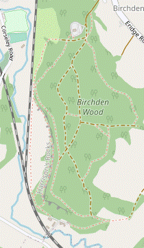 For the full route, head south on Park Corner Lane to Eridge Road. Continue in the same direction along a farm track past Pinstraw Farm. Fork right into Birchden Wood, turning left at a path junction to come to the top of Harrison's Rocks. Go down through a cleft in the rocks and head north on any convenient path parallel to the rocks. At the end join the public footpath alongside the Spa Valley Railway (SVR) and follow it around Birchden Wood (or cut through the wood), eventually going out along the access road from its car park. Shortly before it comes out onto Eridge Road turn left onto a footpath.
- For a short cut, head west along Station Road for 350m and take a footpath on the left across a field. Turn right briefly onto Eridge Road, then turn left into the access road to Birchden Wood.
-
Main route (3¼ km)
- Turn left onto Park Corner Lane and follow it S for 500m, climbing gently at first, to reach a T-junction with a minor road at Park Corner. Cross the road carefully, slightly to the left, and take the “Private Road to Pinstraw Farm” (briefly rejoining the TWCW & HWLT on this public footpath).
- After passing the farm buildings the footpath becomes a pleasant tree-lined green lane, with glimpses across a valley on the left. The footpath eventually swings right and you might have to negotiate a potentially muddy narrow stretch between hedges for about 100m.
-
At Forestry England's Birchden Wood the path splits, with the signposted public footpath continuing down to the left.
- If you want to curtail the walk by finishing at Eridge station (2 km away) fork left, staying on the public footpath. At Forge Farm Oast turn left and follow its driveway across a stream and then the railway line at a level crossing. Turn left onto Forge Road and go all the way along it to reach the station (with The Huntsman pub 100m past the station entrance).
- To continue the walk fork right into the wood, leaving the waymarked trails again. In 50m ignore a path down to the left which rejoins the public footpath. In a further 50m turn left at a T-junction onto a broad forest track, with a wire fence on your left for the first 150m.
- At the end of the fence bear left and make your way through the undergrowth to come to the top of Harrison's Rocks. After continuing along them for a short distance you will find a flight of stone steps cut into a cleft in the rocks.
-
Go down these steps and bear right, crossing a small dip on a plank bridge with a wooden handrail. Continue on the “climbers' path” alongside the base of the rocks, soon turning right to head N.
- If this path is too uneven there are several link paths down to an easier “walkers' path” a little way below the rocks; the two paths merge about 500m ahead.
- After passing the last of the rocks there is a wooden gate on the left. Go through this and turn right onto a public footpath alongside an embankment carrying the Spa Valley Railway? (SVR), rejoining the TWCW & HWLT.
-
In 50m an opening on the right leads back into Birchden Wood. Unless you want to cut through it keep ahead on the footpath outside the wood, which gradually moves away from the embankment.
- Climbers use these short cuts to return to the car park, but the woodland paths are crossed by tiny streams and can be tricky after heavy rain.
- On the suggested route the footpath crosses a stream at a potentially muddy spot, veers right and goes across a small open area. After going back into the edge of the wood the path passes the site's car park (which has a toilet block in the centre) on the left. In the corner of the car park turn left onto a forestry track, the main exit from Birchden Wood.
- The forestry track leads out onto the access road. Follow it away from the car park, up a slope and round to the right. In 200m (and just before the last speed bump) turn left through a small metal gate onto an enclosed path.
-
Short Cut (¾ km)
- Cross over Park Corner Lane and head W along Station Road. In 350m, and 100m before a Groombridge village sign, go over a stile on the left beside a metal fieldgate. Follow a faint grassy path heading SW across a field.
-
On the far side pass to the right of a house, going alongside its garden fence. Go over a stile and turn right onto a minor road, then in 50m turn left into the access road to Birchden Wood. In 50m turn right through a small metal gate onto an enclosed path.
- Birchden to Groombridge (Station Road) (1 km)
- Follow the enclosed footpath between fields and across the SVR into Groombridge. Turn right onto Corseley Road, leaving the HWLT. In 250m cut through a cul-de-sac on the right (Gromenfield) and turn left onto Station Road.
- Follow the potentially muddy enclosed path for 400m, then across the railway on a long footbridge (with Groombridge station visible off to the right). On the other side go past a primary school and turn right onto Corseley Road, leaving the HWLT.
- Go along this tree-lined street for 250m, passing the church of St Thomas the Apostle? and some residential streets. At a junction with Orchard Rise on the left, turn right into a byway and immediately fork left into a cul-de-sac, Gromenfield. Where this turns left, keep ahead on a short tarmac path leading to Station Road.
-
Unless you want to detour up to the road bridge for a view of the SVR's Groombridge station?, turn left onto the road. After passing the access road to the old station building (Newton Willows) you come to the Junction Inn on the left, a possible mid-afternoon refreshment stop.
-
There is also a kiosk on the SVR platform serving snacks when trains are running; access is through the old station building and round to the right, under the road bridge. You could also shorten the walk with a trip on this heritage railway:
If you take the train to High Rocks Halt, continue the directions at §K.
If you take the train to Tunbridge Wells West, follow the brown tourist signs along Linden Park Road to The Pantiles and complete the directions at §L.
-
There is also a kiosk on the SVR platform serving snacks when trains are running; access is through the old station building and round to the right, under the road bridge. You could also shorten the walk with a trip on this heritage railway:
- Groombridge (Station Road) to High Rocks (3½ km)
- Go through the recreation ground opposite the Junction Inn and down a path towards Groombridge Place, crossing a stone bridge over the River Grom. Stay on the TWCW as it goes up the Grom valley, passing Groombridge Place Gardens and later moving away from the river. After skirting a wastewater treatment plant go straight across Broom Lane. Turn right at a path junction to go back towards the river and continue through a wooded area. The path eventually swings right, crosses the river and goes under the SVR to reach a minor road by High Rocks Halt. Turn left onto the road to come to the High Rocks Inn.
- From the pub cross Station Road and go through a side gate into the recreation ground opposite. Pass to the right of a children's playground and continue near the right-hand side of the ground to the far corner.
- Go through a gate onto a fenced path which turns left downhill, then turns half-right near the bottom. Continue on a track leading up to a stone bridge and cross the River Grom? in front of the moated Groombridge Place?.
- Unless you want to detour to see the front of the house, turn right on the other side of the bridge. Where the drive bends left towards the back of the house keep ahead on the waymarked footpath, which crosses a stream and continues as a long straight fenced path across a meadow.
- On the far side the path continues alongside a waterway for 100m, with the “Enchanted Forest” of Groombridge Place Gardens? on the other side. Cross a stream on a wooden bridge and keep ahead along the left-hand edge of a field, later turning slightly left and climbing gently. Go though a metal side gate and cross a driveway to continue along an enclosed path.
- In 100m the path turns sharply right and you will soon realise that you are passing a large wastewater treatment plant behind the black metal railings. In 200m the path swings left to skirt around the site in a wide arc before coming out onto Broom Lane. Cross the road to continue along the driveway opposite, with a yellow footpath waymarker.
- In 250m go across a parking area in front of a property and down a grassy slope towards a footbridge. Cross the stream, go through a metal gate and turn right at a path T-junction. Follow the path round to the left and through a metal kissing gate. Where the path splits fork right as indicated to go gently downhill on a broad grassy path between trees and a wire fence.
- At the bottom of the slope go through another kissing gate by a large oak tree, back close to the river again. You now simply follow the path through a wooded area for 600m, with ‘Private’ notices to keep you on the right of way. Eventually the path turns right, crosses the river on a footbridge and passes under the railway.
- Bear left uphill on the other side and turn left onto a minor road (High Rocks Lane) by the entrance to High Rocks Halt on the SVR. You soon pass the High Rocks Inn on the left, a possible refreshment stop with a large garden overlooking the heritage railway station.
- Birchden Farm to South Farm Drive (1½ km)
- Turn right, cross Broadwater Forest Lane and take the footpath to the right of the farmhouse, heading north. At South Farm turn right at a footpath junction and go past outbuildings onto its driveway, heading north-east.
- Turn right onto Park Corner Lane and go up to the T-junction. Cross Broadwater Forest Lane (slightly to the right) and go through a gap at the right-hand end of the low brick wall in front of the old farmhouse, with an inconspicuous concrete footpath marker. Go past the house and keep ahead on a concrete track past some farm buildings.
- At the far end go across a small open area onto a grassy path going gently uphill alongside a wood, with a vineyard off to the left. At the top of the rise go through a new wooden kissing gate on the left to continue in much the same direction along the right-hand edge of a large field, with views ahead across the Grom valley.
- After passing a double metal fieldgate on the right stay near the right-hand edge, now going steadily downhill. In the field corner go through a gap and continue on a broad woodland path. At the bottom of the slope cross a stream on a stone bridge and keep ahead along the right-hand edge of a small field. Bear slightly right up a grassy slope and go past an outbuilding to come to a footpath T-junction.
- Turn right and follow a track past some farm buildings, going up a few steps along the way. Continue through a parking area onto a driveway heading NE, initially between tall hedges and later with paddocks on the left. In 350m there is a footpath ahead where the drive turns half-right.
- South Farm Drive to High Rocks (2 • 1¼ km)
-
For the main route, leave the drive where it turns half-right and keep ahead on a footpath to reach Broom Lane. Turn left and follow it under the Spa Valley Railway (SVR). Opposite the entrance to a wastewater treatment plant turn right onto a footpath, joining a link route for the TWCW.
…
- For a short cut along roads, stay on the farm drive and follow it out to a crossroads. Head north-east on Hillswood Road and High Rocks Lane to High Rocks.
-
Main route (2 km)
- Keep left at the junction, towards a few houses. Go over a stile to the right of the entrance to these properties into the corner of a triangular field and keep ahead along its left-hand edge. On the far side go over another stile and through a belt of trees to a minor road (Broom Lane).
- Turn left onto the lane and follow it downhill round a couple of bends. It goes under a railway bridge carrying the Spa Valley Railway? (SVR), passes the entrance to a campsite and crosses the River Grom?. After climbing gently for 125m turn right into a driveway opposite the entrance to a wastewater treatment plant, joining a link route for the TWCW.
- …
- …
- … …
-
Shorter route (1¼ km)
- Fork right at the junction and follow the driveway out to a minor road (Broom Lane). Turn right briefly onto the lane, then turn left at a crossroads onto Hillswood Road, heading NE. In 500m the road merges with Fairview Lane from the right and becomes High Rocks Lane.
- In 400m the main route joins from a footpath on the left by the entrance to High Rocks Halt on the Spa Valley Railway? (SVR). You then …
- High Rocks to The Pantiles (2½ km)
- Go past the High Rocks Inn and bear right onto a path through Friezland Wood. In 500m ignore a track leading under the railway to stay on the TWCW, later going through Three Acre Wood and along a semi-open area leading to a new housing estate. Go through this to the A26, then up a tarmac path onto Tunbridge Wells Common. Turn right to head east on a woodland path roughly parallel with the main road, eventually dropping down to rejoin it. Cross the road and go down Swan Passage into The Pantiles.
- Unless you want to visit the privately-owned High Rocks? (its entrance is directly opposite the inn) carry on along High Rocks Lane. Just before it crosses over the railway bear right past a wooden barrier into the Woodland Trust's Friezland Wood.
- Follow the main path as it goes between the railway and the impressive rock outcrop. Eventually the path drops down and goes alongside the river for 100m. At the end of this stretch ignore a track off to the left going under the railway and bear right to continue through the wood.
- In 150m bear left through a wooden gate with a TWCW marker, leaving the Woodland Trust site and entering Three Acre Wood. In a further 100m fork left at a Y-junction and follow the path down a slope. At the bottom cross a ditch on a plank bridge to leave the wood. Continue on a long straight path through a semi-open area sandwiched between the railway and the Ramslye housing estate.
- At the far end go through a gate and continue beside a row of new houses on a paved cul-de-sac (Spring Walk). Follow the street round to the right, then turn left to go past a few more houses. Keep ahead on a tarmac path leading to the A26 and turn left to go under the railway bridge.
-
Immediately after the main road curves to the right past a garden centre, turn left at a footpath signpost onto Tunbridge Wells Common. For a straightforward route, follow this tarmac path into a wooded part of the common and then steeply uphill for 125m. At a major path junction (with a byway on the left) take the right-hand of two paths off to the right.
- Shortly after the tarmac path enters the wood you could take a side path on the right; this climbs less steeply and merges with the main path 200m further on.
- Either way, follow the main path through the woodland, roughly parallel with the A26 off to the right and heading E. At the end of the trees the path drops back down to the main road, with a mini-roundabout ahead.
- In front of the roundabout cross the A26 with great care and go down a stepped passageway to the left of the Tunbridge Wells Hotel. At the bottom of Swan Passage turn left onto an attractive pedestrian area, The Pantiles.
- The Pantiles to Tunbridge Wells Station (¾ km)
-
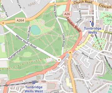 Head north-east along The Pantiles and cross Nevill Street into Cumberland Walk, which leads into the High Street. At the far end go across Vale Road to the station.
-
To complete the walk head NE along The Pantiles, which has many possible refreshment places. At the far end you pass the spa town's chalybeate spring shortly before emerging into Nevill Street. Cross over this main road at the traffic lights and go into Cumberland Walk opposite.
- In 20m turn left up some steps to an alley and keep ahead along the (initially pedestrianised) High Street. There are plenty more cafés, coffee shops and delis along this street: Juliets is on the left about halfway along, at #54.
-
At the far end of the High Street the main station entrance and ticket office is down to the left on the other side of Vale Road, along Station Approach. Most trains to London depart from Platform 1, on that side.
-
If you do not want to dodge the traffic on Vale Road you can reach the alternative station entrance in Mount Pleasant Road (straight ahead) via two sets of pedestrian traffic lights. There is an overhead walkway linking the two platforms.
-
If you do not want to dodge the traffic on Vale Road you can reach the alternative station entrance in Mount Pleasant Road (straight ahead) via two sets of pedestrian traffic lights. There is an overhead walkway linking the two platforms.
- Calverley Grounds were originally the pleasure grounds of Mount Pleasant House, later the Calverley Hotel. They were purchased for the town in 1920. Near the main entrance there is a memorial to Lord Dowding, the commander of RAF Fighter Command during the Battle of Britain (1940).
- The present Tea House is a replica of one which burnt down in 1997. A concert pavilion and bandstand on the site were destroyed by an air raid in 1940.
- The Grove was originally a small wood which was placed into a Trust by the Duke of Buckingham in 1703 “to be preserved for the use of all inhabitants”. It has been managed by the local council on the same terms since 1890.
- The Nevill Crest is a bull with a crown around its neck. The family motto Ne vile Velis (‘never have evil thoughts’) incorporates their name, then spelt Nevile.
- The 44 km Tunbridge Wells Circular Walk (formerly the High Weald Walk) was established by the Borough Council as one of its centenary events in 1989.
- The High Weald Landscape Trail runs for 145 km across the length of the High Weald, mostly near its northern edge, from Horsham in West Sussex to Rye.
- St Alban, Frant was almost completely rebuilt in 1822 when the medieval church became uneconomic to repair. It has a particuarly fine August Gern organ.
- On Frant's Old School, the inscription Train up a child in the way he should go: and when he is old, he will not depart from it is from Proverbs 22:6.
- The unusual name Bells Yew Green is derived from the medieval French Bels Lieux (the ‘beautiful place’ being the nearby Bayham Abbey).
- The spacious parkland of Eridge Old Park was landscaped in the late 18thC by Henry Nevill, the 2nd Earl of Abergavenny, who built Eridge Castle in Strawberry Hill Gothic style.
- This man-made lake provided the water power for a 16thC iron foundry, part of the extensive Wealden iron industry.
- The Georgian style mansion of Eridge Park was built in the 1930s, replacing Henry Nevill's more exotic Eridge Castle.
- Holy Trinity, Eridge was built in 1851 as a Sunday School and consecrated five years later. It was completely refurbished in 1950 and has several features associated with the Abergavenny family.
- The Gun was a large cannon made from the local forge. The elaborate letter A's stand for [Earl of] Abergavenny.
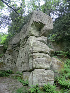
- Eridge Rocks is a Site of Special Scientific Interest because the rocks support a great variety of tiny ferns, mosses, lichens and liverworts. Some climbing is permitted but there are more restrictions than at Harrison's Rocks.
- The Broadwater Warren nature reserve was acquired by the RSPB in 2007. The society is gradually transforming the “dark and lifeless” Broadwater Forest to “a mosaic of open heathland, woodland and boggy valley mire”.
- The River Grom is a tributary of the River Medway, joining it 2 km west of Groombridge.
- The Spa Valley Railway began operating steam and diesel trains from Tunbridge Wells West in 1997, at first to Groombridge and then Eridge in 2011. The line had been closed by British Rail in 1985, some years after the Beeching Report.
- St Thomas the Apostle, Groombridge (in the diocese of Chichester) was designed by the famous architect Norman Shaw. It was built to serve the new community which developed after the arrival of the railway and opened in 1884.
- The line through Groombridge station used to carry trains to London, Three Bridges, Brighton and Eastbourne. The SVR platform had to be re-sited on the other side of the road bridge because the station building had been converted into a private residence.
- The present house at Groombridge Place was built in the early 17thC on the site of a medieval moated house (and possibly an earlier Saxon fort). A 12 year-old French Count was held hostage here in the Hundred Years War until his ransom was paid 30 years later. It was the setting for Peter Greenaway's 1982 film The Draughtsman's Contract and was used for Longbourn in the 2005 adaptation of Pride & Prejudice.
- Groombridge Place Gardens are a popular visitor attraction, combining 17thC formal walled gardens designed as ‘outside rooms’ of the house, and the Enchanted Forest which aims to “intrigue, amuse and entertain”.
- There is a fee to enter the grounds of High Rocks, where the sandstone outcrops have been linked by ornamental bridges.
Continue the directions at §D.
There is a choice of routes to start this section, but neither is ideal. The main route is along a footpath but this can only be reached via an initial stretch along a busy narrow road with no pavement (including a particularly awkward spot under a railway bridge with limited visibility). The less hazardous alternative route in [?] is entirely along roads.
The suggested route through Broadwater Warren to the Birchden Farm exit mostly follows (in reverse) the RSPB's Heathland and Woodland Trail (H&WT), waymarked with green arrows.
If you are doing the shorter afternoon (omitting Groombridge), go to §I.
If you want to take a short cut (omitting the loop past Harrison's Rocks), follow the directions in [?].
Continue the directions at §K.
If you want to take a shorter route along roads (which also bypasses some potentially muddy stretches), follow the directions in [?].
Walk Notes
» Last updated: November 20, 2023
Return to Top | Walk Map | Walk Options | Walk Directions.