Uckfield to Lewes walk
A gentle walk along river valleys through fields and woods, finishing with a climb over the South Downs above Glyndebourne

View up Caburn Bottom to Caburn Hillfort (with cows)
SWC Walk 272 Uckfield to Lewes
Apr-17 • thomasgrabow on Flickr
swcwalks swcwalk272 banner 33308158993
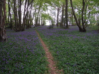
Bluebells in Unnamed Wood near Owlsbury Farm
SWC Walk 272 Uckfield to Lewes
Apr-17 • thomasgrabow on Flickr
swcwalks swcwalk272 walkicon 33308394893
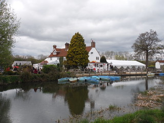
The Anchor Inn & Boating on the River Ouse
SWC Walk 272 Uckfield to Lewes
Apr-17 • thomasgrabow on Flickr
swcwalks swcwalk272 walkicon 33277313594

Millstream, from Pikes Bridge, Barcombe Mills
SWC Walk 272 Uckfield to Lewes
Apr-17 • thomasgrabow on Flickr
swcwalks swcwalk272 walkicon 33989580501

Itford and Beddingham Hills
SWC Walk 272 Uckfield to Lewes
Apr-17 • thomasgrabow on Flickr
swcwalks swcwalk272 walkicon 34078884496

Lewes and River Ouse, from descent path along road from Golf Club
SWC Walk 272 Uckfield to Lewes
Apr-17 • thomasgrabow on Flickr
swcwalks swcwalk272 walkicon 34078865626
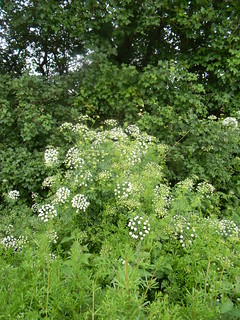
Hemlock Water Dropwort
Britains most poisonous plant emj.bmj.com/content/19/5/472.full" rel="nofollow emj.bmj.com/content/19/5/472.full Uckfield to Lewes
pretty swcwalks newwalks uckfieldtolewes 7155743465
| Length |
20.9 km (13 miles) |
|---|---|
| Toughness |
4/10 |
| Walk Notes |
A gentle walk along river valleys through fields and woods, finishing with a climb over the South Downs above Glyndebourne |
| Walk options |
(b) The afternoon climb onto the downs can be avoided by following the Ouse Valley Way all the way to Lewes. This reduces the total length to 18.2km (11.3 miles) with a toughness rating of 2/10. The walk can be shortened by taking a bus to Lewes, Brighton or Uckfield from Ringmer. |
| Transport |
Take the train nearest to 10:00am (or 9:00am) from London Bridge to Uckfield. On Sundays take the train nearest to 9:45am (or 8:45am) from Victoria or London Bridge to East Croydon and change there for Uckfield. Buy a return ticket to Lewes, which is accepted on the outward journey to Uckfield. |
| Lunch |
The Anchor Inn (tel: 01273 400414) , on the banks of the River Ouse, provides meals and also offers boating on the river. Take the earlier train to reach the inn by 12:30pm, or the later one to arrive by 1:30pm. |
| Tea |
There are several tea places in the centre of Lewes. |
| Profile | |
|---|---|
| Help Us! |
After the walk, please leave a comment, it really helps. Thanks! You can also upload photos to the SWC Group on Flickr (upload your photos) and videos to Youtube. This walk's tags are: |
| By Train |
Out (not a train station) Back (not a train station) |
| By Car |
Start TN22 1HS Map Directions Return to the start: Finish BN7 2UP Map Directions Travel to the start: |
| Amazon | |
| Help |
National Rail: 03457 48 49 50 • Traveline (bus times): 0871 200 22 33 (12p/min) • TFL (London) : 0343 222 1234 |
| Version |
Apr-24 Chris L |
| Copyright | © Saturday Walkers Club. All Rights Reserved. No commercial use. No copying. No derivatives. Free with attribution for one time non-commercial use only. www.walkingclub.org.uk/site/license.shtml |


Walk Directions
- At Uckfield station, exit at the front of the platform, cross the main road, turn right and cross the bridge over the River Uck.
- At Bridge Cottage turn left into Bell Walk shopping precinct. Bear half right across a car park, go past a bus station and the Uckfield Club on your right, still bearing right, and turn left at the roundabout on the B2102, signposted ‘out of town’.
- Cross the road, go past a fire station and in 120m follow the tarmac path as it turns right. [Alternatively, if you don't mind walking alongside the main road, continue straight ahead on a grass path for 750m, parallel with the road to your left, until you reach Batchelor Way, continuing at 5.]
- In 40m, where tarmac paths cross, turn left on a path running between houses to the right and a belt of woodland to the left. Keep close to the woodland and in 600m pass Meads Medical Centre to continue straight ahead. At a T-junction, turn right and immediately left across a bridge over a ditch, and follow the path out to Batchelor Way.
- Cross the main road, turn right and in 130m turn left at the roundabout on to the A22, immediately crossing it and turning left.
- In 70m cross a concealed double stile on the right just before a metal fieldgate and go half left across a field. In 110m cross a stile and go along the left-hand edge of a field.
- In 150m cross a stile to go through a wooded area and over a wooden footbridge into the next field to follow a fenced path along its left-hand edge. Over to the left can be seen the embankment of the never completed Ouse Valley Railway.
- At the corner of the field follow the path round to the right between barbed-wire fences to cross a stile in the next corner. Go through a wooded area, passing a brick abutment of the unfinished railway, and following the path as it emerges at the corner of a field.
- Go straight ahead, to the left of an oak tree, along the right-hand edge of a field for 200m (direction 210°). At the far end turn left along the laft-hand edge of a field.
- In 80m go through a gap ahead and bear very slightly right (direction 140°) across a field to cross a stile on the far side.
- In 80m cross a wooden footbridge over the River Uck and turn right. In 120m turn left on a car-wide track which in 200m meets the trackbed of the disused Uckfield to Lewes railway line.
- Turn right for 5m on this track to then cross a stile on the left. Bear slightly right across a field to go over a stile into a wood.
- In 110m exit the wood over a stile, turn right and in 20m cross a stile on the left to go half-right up a field (direction 130°), aiming for the right-hand edge of a small copse. Leave the field through a metal fieldgate hidden behind the copse, 60m before the field corner, and turn right on a lane.
- Pass large industrial-style farm buildings on the right and continue for 700m. Horsted Place is visible ahead to the left, and there are fine views to the right.
- [Just after passing a house named Stroodlands, there is an option to save 500m by following a green lane. Just after the lane bends left, turn right on a grass track and in 30m, just before reaching a metal fieldgate, bear left on to a narrow path, which runs through a narrow belt of woodland between fields for 800m and then continues as a tarmac lane. Continue at 18. This path is sometimes heavily overgrown, deliberately so, to deter its use by SUVs and off-road vehicles. Only attempt this short-cut if you are prepared to deal with a seriously-obstructed path]
- For the main route, continue on the lane for a further 450m to turn right on to a signed footpath along the edge of a field. In 90m pass under powerlines and soon come out on to a golf course. Follow the footpath direction arrows on posts to descend to a tarmac path that soon bends left. At the bend turn right on to a grassy path that passes through an arch cut in a hedge.
- Turn left on a wide grassy path, with the golf course to the right, behind trees. In 200m the path emerges on to the golf course. Cross the fairway ahead to a tarmac path and turn left to descend and follow the path round to the left. In 50m leave the golf course through a gap in the hedge and turn right on a lane which turns left in 80m.
- Note a roadside flood depth indicator that is rarely needed. In 120m turn right to cross a wooden footbridge and stile on a narrow path, sometimes quite overgrown, and shortly turn right on a grassy path through a field. [If the narrow path looks heavily overgrown, continue on the lane for 110m to enter the field through a gap, turning right immediately on to the grassy path.]
- On the far side of the field, turn right to cross a wooden railed footbridge over the River Uck and go straight on, aiming for a wooden pylon pole beside a loop of the river. Continue in the same direction for 80m and then bear left beside the river to pass under the metal frame of an old railway bridge. Here you can see the Dingley Dell terminal of the Lavender Line which terminates on the other side of the disused bridge.
- The path bears left alongside the river, passing through a rusty orange gate. In 250m emerge into an open field and continue straight on towards a bridge on the far side. Cross this wide metal-railed footbridge and turn right to continue alongside the river.
- Just past a disused metal kissing-gate, go through a gap on the right into the next field and turn left. In 110m go through a metal fieldgate, then in 180m cross a metal stile and go ahead up a farm track towards the buildings of Tile Barn Farm.
- Immediately before some large farm buildings ahead turn right along a wide stony track. [New fencing and gates across this track were being installed in Sept 2020] Pass through or over whatever gate/stile you find, and as the track turns left, turn right on a footpath into a wooded area. In 30m go through a tall wooden gate and turn left along a gravel drive to reach a road.
- Turn right on the road and 30m past Isfield Village Hall, turn left through a gap in the hedge to cross a small field to a kissing-gate in the far corner.
- Go along the edge of a field, turning left at a fence corner. At the far end, cross a stile and turn right along a stony track (bridleway).
- Follow the track past a duckpond to the left, ignore a bend to the left and carry straight on.
- Just before reaching a bridge over the River Ouse, cross a stile on the left to join the Ouse Valley Way and follow the river bank for 1.8km till you come to the Anchor Inn on the other side of the river, which you cross at this point on a concrete bridge.
- On coming out of the pub, stay on that side of the river and go through the carpark opposite to pass through a kissing-gate beside a weir. with fine views of the South Downs to the left.
- Go through two gates and pass an old pill box. Just after passing a converted barn on the left, turn left past a gate and go over a concrete bridge to turn right on the other side of the river.
- In 450m go over a footbridge across another branch of the river and continue alongside the river past a large reservoir up to the left. In 800m cross another footbridge and soon go up steps and through a squeeze stile to come out on a lane. To the right can be seen the sluices and river pools of Barcombe Mills. Here you have two options.
- To continue along the Ouse Valley Way to Lewes, go to Alternative Route from Barcombe to Lewes along the Sussex Ouse Valley Way, at the end of the Main Walk directions.
- To continue on the main route, turn left on the lane and, just before it joins a road, fork left on a footpath to cross a car park and in 40m, go through a gap in the hedge to cross a large field just to the right of a small copse.
- Leave the field beside a disused gate, continue along a tarmac drive towards a pumping station and just before its antrance gates bear right to go along the left-hand edge of a field. Keep the pumping station enclosure to the left and in 250m turn right towards a wooden pylon pole, with a short hedge to the left.
- Go through a gap and cross a field to a redundant stile, then in 30m cross a grassy bank across a ditch to the right and follow the right-hand edge of a field to reach the A26 main road.
- Cross the road with care and go up the drive of Clayhill House opposite. Keeping to the left of the house and pond, take a grassy track which swings round to the right. Fork left to go through a new kissing gate and another further on to go up a wide grassy track between two fields (direction 140 °).
- Go past a trig point and through a wooden fieldgate. Ignore a new permissive path off to the left and continue towards a small wood, with a fence on your right; along the way you pass a dew pond on your left.
- Go through a lightly wooded area (with the fenced wood on your left) to join a wider track and cross a cross a stile. Follow this potentially muddy path for 200m between hedges to go past a house on the right and continue on a tarmac lane towards Little Norlington.
- At a T-junction in 250m turn right onto a quiet country lane. Follow this for 600m, eventually passing Norlington Gate Farm. 30m after the lane crosses a stream, turn left onto a short grassy track between a copse and a hedge.
- Go through a gap in the hedge by a footpath signpost, turn half-right and follow a clear path across fields for 600m, heading south, slightly to the right of the wind turbine in the distance.
- At a footpath junction cross a wooden railed footbridge through a gap in the hedge and continue in the same direction alongside a hedge. In 200m veer right through a gap in the hedge over a plank footbridge and turn left onto a short tarmac road (75m) on the outskirts of Ringmer.
- At a T-junction turn right onto Bishop’s Lane to come to a corner of the long village green. Bear left and go all the way across the green for 250m to the B2192, staying close to the lane on your left. The Anchor Inn is off to the right and there are bus stops here with frequent services to Lewes, Brighton and Uckfield. Cross the busy road carefully and go past a Millennium clock tower into Springett Avenue, signposted to Village Shops.
- Follow this wide residential road for 600m as it bears right past a parade of shops, then later takes a long curve to the left.
- At a T-junction at the end of the road, cross over and take the footpath opposite (slightly to the right). Go through a wooden kissing gate and follow a grassy path across a field for 250m. Go through a gate in the hedge and bear right to cross a smaller field .
- In 125m go through a gate and continue uphill for 225m on a chalky path. Go through another gate and bear left up a grassy slope (with no clear path) towards the wind turbine. In 200m, as you reach the brow of the hill, go through a gate in the hedge onto a grassy area containing the Glyndebourne Wind Turbine and a large weathered timber pillar.
- Bear right to descend gradually over open turf alongside a hedge to the right and take a short path down to a road. Cross the quiet road to go straight up a sunken rutted lane opposite (Week Lane). Near the top, look through a gap on the left for a view of the Glyndebourne opera house way below, just visible through the trees.
- Cross a stile beside a metal fieldgate (40m to the left, a footpath leads directly down to Glyndebourne). Ignoring the track ahead, fork right past a dewpond on a grassy path leading to the upper edge of a small wood.
- Go up past the wood to a signpost and enter the Southeram Nature Reserve. Follow a clear path above a deep depression (Bible Bottom) on the left. In 500m you go through a gate in a fence and the path forks, with the main path going straight on and a narrower path slightly to its right. leading in 300m to a stile onto Lewes Golf Course. The latter path is the official public footpath shown on the OS map, but it is easier to stay on the main grassy path which skirts the golf course and comes in 1.2km to the club house.
- Turn right through a wooden gate and go down the golf club’s access road, using the raised footpath to the left of the road for most of the way. This road later becomes a steep lane (Chapel Hill) as it descends into Cliffe.
- Cross the road at the bottom and go straight on. In 200m cross a bridge over the River Ouse. to enter Lewes along a pedestrianised street, where a range of refreshment places can be found. To go straight to the station turn left in 100m down Friars Walk, turning left again at its end. Or for more tea places continue up the main road ahead.
Alternative route from Barcombe to Lewes along the Sussex Ouse Valley Way
- Turn right onto the lane, as signposted. Follow the lane as it bends left and right [150m] across various mill streams, sluice gates, etc. Shortly after the last of these, turn left onto a track heading west and follow this for 250m to join a road.
- Continue in the same direction on the road (taking care as there is no pavement) for a further 250m, crossing the trackbed of the Uckfield-Lewes line (with a British Railways notice about flooding!) by the old Barcombe station buildings, now a private residence.
- Where the road turns sharply right, go over a stile on the left and take the leftmost of three footpaths, along a field edge and past a WW2 pillbox. Follow a clear path south-west across several stiles and footbridges for 400m, where you cross over the low embankment of another dismantled railway, between East Grinstead and Lewes. Continue for a further 150m to the edge of a large field.
- Turn half-right to go diagonally across this field for 225m, aiming just to the right of a house if there is no clear path. Go through a gate and keep ahead for 50m across a small field to the far corner, then along a short path past a house to come out on its driveway. Go along this for 50m to a crossing with a farm lane.
- The SOVW continues ahead but the following detour through the small village of Barcombe is recommended. Turn right onto the lane, then left at a T-junction. Continue past several large houses, then in 150m turn left into the short access road for the church of St Mary the Virgin, signposted as a public footpath. This passes a very picturesque house and garden, complete with a large pond and semi-detached duck-house.
- The continuation of the route is through a wooden fieldgate on the left at the start of the churchyard, so return to this point if you visit the church. Go through the fieldgate, across a small field, through another gate and across a second field [200m in total]. In the far corner cross a footbridge in a gap in the hedge to rejoin the SOVW.
- Go along a track for 600m, heading for the buildings of Cowlease Farm. Go past some barns and bear right to go past the right-hand side of the farmhouse. Continue in the same direction along a clear path for 400m to the start of a belt of trees.
- The right of way appears to be in a sunken path just inside the trees but it is much easier to continue along the field edge beside them. At some point in the next 200m or so veer right onto the path, which later goes between hedges [500m in total] and joins a green lane by a gate. Continue along this track for 150m to meet a lane.
- Turn left onto the lane and follow it through the small village of Hamsey, curving round to the left. In 300m the lane turns sharply right to go alongside a cut of the River Ouse. In a further 100m it comes to a junction.
- Go straight on at the junction onto a rough track, at first alongside the channel and later the main branch of the river, which you then simply follow all the way into Lewes. Looking back on your left you can see the isolated old church of St Peter, Hamsey, on a low hill.
- In 800m the river bends left in front of the main railway line, with Book 1’s Walk 29 (Hassocks-Lewes) joining from a path under the railway bridge. Continue along the riverside path for a further 1½ km to the outskirts of Lewes.
- Shortly before reaching a pedestrian footbridge across the river, veer right onto a path. In 75m this leads to a broad path going alongside a body of water for 150m, later with a swimming pool on the left.
- Where the channel turns sharply right, go straight on up St John’s Hill. In 100m veer left and right by the entrance to the church of St John sub Castro. Go along Abinger Place for 100m to its junction with the A1029.
- Cross this main road carefully and continue steeply up Castle Banks opposite. At the top bear right past a viewpoint with an information panel about the Battle of Lewes (1264). Follow the lane as it curves left past a bowling green, down through the medieval Barbican and past the ruins of Lewes Castle to the High Street.
- Turn left onto the main road, coming in 100m to the White Hart Hotel on the right. Continue down the High Street to find further tea places. Turn right at the main crossroads to reach Lewes station.