Walks from Ambleside walk
Low to mid level walks from Ambleside in the Lake District
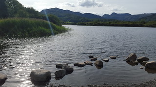
Elterwater circular walk
swcwalks swcwalk199 walkicon elterwater cumbria 43012075285

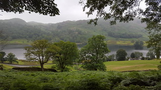
Ambleside circular walk via Grasmere
swcwalks swcwalk199 rydal cumbria 43835688662
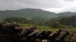
Ambleside circular walk via Grasmere
swcwalks swcwalk199 rydal cumbria 28947366487
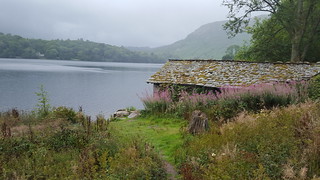
Ambleside circular walk via Grasmere
swcwalks swcwalk199 grasmere cumbria 43166560404
Ambleside circular walk via Grasmere
swcwalks swcwalk199 grasmere cumbria 30014398398
Ambleside circular walk via Grasmere
swcwalks swcwalk199 rydal cumbria 43166566064

Ambleside circular walk via Grasmere
swcwalks swcwalk199 ambleside cumbria 30014409988
| Length | 3 to 5 miles |
|---|---|
| Toughness | 4 / 10 |
| Walk Notes |
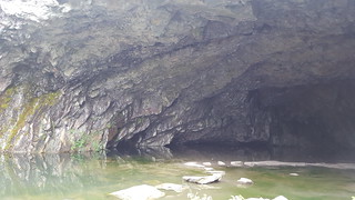
These are all low to mid level walks from Ambleside in the Lake District - that is including some climbing, but not going up onto the high mountains. 1) The classic route from Ambleside is to walk to Grasmere and back, up one side of the valley and back the other, in both cases on mid-level terrace routes with fine views. The round trip is about 7 miles and Grasmere has plenty of nice places for lunch and tea. Directions from Ambleside to Grasmere via the “coffin route” (when Grasmere did not have a church, coffins came this way to Rydal) are found here (ignore preamble at top of page and just follow numbered directions) http://www.golakes.co.uk/thedms.aspx?dms=13&feature=20&venue=5058427 To return, find the minor road that comes south east out of Grasmere on the far side of the lake from the main road. After a while skirting the lake, there is (from memory) a signposted path off to the left, or stay on the road as it climbs the hill, and look out for a path on the left near the top. This takes you out onto the open fellside, with Loughrigg up to your right, and two paths then terrace around this – a lower and an upper one, with Rydal Water lake below you to the left (note: a different lake from Grasmere, the lake you originally started walking along). The upper path eventually passes an amazing cave. Both paths bring you in due course to a point just beyond the end of the lake when you come to a minor road, with the main road over to the right. Turn right on the minor road, and it takes you right along a very pretty valley edge to Ambleside, which is signposted across the pack horse bridge just after you pass a cattle grid. 2) Another fine walk is to walk up over Loughrigg, down to Loughrigg Tarn (very picturesque) and to Elterwater (3-4 miles). To do this find the church in Ambleside, and then the driveway leading past it into Rothay Park. Slant across this on the path until you come to its far corner, where you cross a packhorse bridge onto a very minor road. Turn right on this over, and then shortly afterwards turn left up a tarmac driveway that climbs steeply up the hill. If you follow this driveway (which later becomes a broad gravel path) it will take you right up over Loughrigg (but see option 2a below) and down to Loughrigg tarn, and if you follow the road around the tarn that will take you on into Elterwater, which has pubs and a tea room. You can carry on up the valley (Langdale) from Elterwater for about two and a half miles to the New or Old Dungeon Ghyll Hotels (there are two of them, about 500 metres apart), from where the buses come back to Ambleside. This last bit up the Langdale valley is stunning, with peaks towering above you. I forget exactly where the path starts in Elterwater, but I am sure if you ask someone can tell you. 2a) My favourite way to vary the above walk – and a fine short walk from Ambleside when you arrive (but not in mist when it is too confusing) – is to cross Rothay Park, turn right on the road and then left on the steep driveway, but when you get to some houses on the steep driveway – Brow Head Farm – and the track turns sharp right, look out for a path to the left, which starts by climbing up stone slabs set into a stone wall, and then goes into a small wood. Take this path, and you soon emerge onto the open fellside. Turn right uphill on a clear path, but almost immediately take a path turning left off this path, which traverses across the slope while climbing gently among hummocks. Here you have to trust to your navigation skills a bit, as it gets a little confusing (do NOT do this walk in low cloud or mist), but basically if you keep taking any path that goes uphill and to the left (or half left) you soon come to a fine viewpoint where you can see both Ambleside and Lake Windermere – this is Todd Crag. From there, head north or north west (ie towards the high fells, away from Windermere) on one of a multiplicity of paths, and you will meet the broad car-wide gravel path that crosses the fell from Ambleside to Loughrigg Tarn: turn right on this to return to Ambleside, or left to go to Elterwater. The link below has another version of this Todd Crag walk, returning a different way to Ambleside from the one described above. http://www.golakes.co.uk/thedms.aspx?dms=13&feature=18&venue=5058427 3) The Elterwater Round is a lovely walk of about 5 miles that introduces you to a range of scenery, including a little taste of the wild mountains. It is probably one of the nicest lower level walks in the Lake District (and it is by no means all flat, by the way). There is a tea shop/café and a pub in Skelwith Bridge. For buses to Elterwater see the start of this document. Here is the route http://www.mikes-walks.co.uk/Walks/Lake_District/DaleHead/Elterwater/elterwater.html 4) The mountain you see towering over Ambleside is Wansfell, and it is not as big as all that: a short climb, though a steep one. To climb it, take the tiny back road that leads up from the right-hand side (?) of the Salutation Hotel, towards Stock Ghyll Force, Ambleside’s waterfall. Visit this, and then look for a gate on the top right hand side of the fenced in area around the waterfall, which takes you back onto the road. Carry on up the road, away from Ambleside and look out for the path leading up the fellside to your right that takes you up Wansfell (it is signposted, as far as I can remember). The path climbs directly (ie steeply) to the summit, from where there are fine views. You can come back the way you came, but a nicer route, not marked on most maps, is to go over the top of the summit, ie onto its south eastern side, and find a path here that meanders more or less down the line of the ridge, with a fine view of Windermere directly in front. After various twists and turns this eventually enters woods, and brings you down to a car-wide path that contours the mountain: turn right on this to return to Ambleside. 5) If you can find the road out of Ambleside that leads up to High Sweden Bridge, this is a lovely walk and highly recommended. The road climbs steeply and then goes through a gate and becomes a stony track, with fine views to the left. It is about a mile and a half to High Sweden Bridge, which is a cute packhorse bridge, situated just after a longish wooded section. For a taste of the wilder mountains beyond, you can either carry on up Scandale, the wild valley beyond, or cross the bridge and climb up onto the ridge on the far side. Turn left on this for a lovely gentle walk down to Ambleside, with wonderful views. This brings you to Low Sweden Bridge, after which you pass through a farm and follow the road back into town. This is a walk of 3-4 miles. In fine weather (ie, not low cloud or mist) for a more adventurous version of this walk (9 miles or so), carry on all the way up Scandale (about four miles), and at the far end follow the path as it climbs up out of the valley to Scandale Pass. At the pass turn right up onto the big bulk of Red Screes – an easy path with no difficulty. Turn right on the summit of Red Screes and follow its ridge (delightfully easy grass – a hands in pockets kind of route!) all the way back to Ambleside, with magnificent views of Windermere. Right at the end you are forced off the ridge onto a road, which you follow downhill into Ambleside. This is a proper mountain walk, though a fairly easy one in terms of the terrain underfoot. 6) The link below has a walk that skirts around the bottom of Wansfell and goes into the interesting high farmland beyond http://www.lakeswalks.co.uk/walks/walk10/index.shtml 7) A very easy walk along Lake Windermere is to take the Windermere Lake Cruises Green Route from Waterhead (the lakeside bit of Ambleside) to Wray Castle, a NT property, and then carry on along the lake edge to the Bowness Ferry, which is a public car ferry that takes you into Bowness, from where you can take the 599 bus back to Ambleside |
| Public Transport |
See PDF above for a guide to walking by bus. |
| Help Us! |
After the walk, please leave a comment, it really helps. Thanks! You can also upload photos to the SWC Group on Flickr (upload your photos) and videos to Youtube. This walk's tags are: |
|---|---|
| By Car |
Start Ammbleside, Cumbria, Map Directions |
| Amazon | |
| Help |
National Rail: 03457 48 49 50 • Traveline (bus times): 0871 200 22 33 (12p/min) • TFL (London) : 0343 222 1234 |
| Version |
Apr-24 Peter |
| Copyright | © Saturday Walkers Club. All Rights Reserved. No commercial use. No copying. No derivatives. Free with attribution for one time non-commercial use only. www.walkingclub.org.uk/site/license.shtml |
