Wendover Circular walk
The Chilterns: gentle wooded hills and ridges.
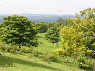
walk 01 View from Chiltern Escarpment
May-04 • Peter Conway on Flickr
swcwalks book2 walk1 36927652430
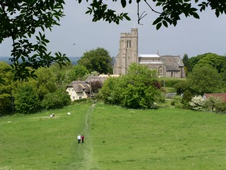
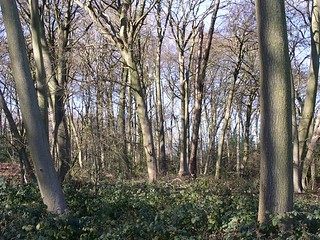

Book 2, Walk 1, Wendover Round
Near Ellesborough.
walk round wendover book2 240905 walk1 swcwalks tocw21 46207735
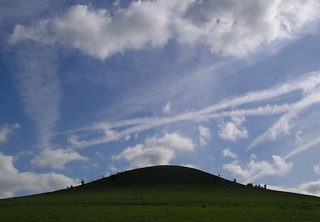
Whiteleaf & Pulpit Hill
| Length |
Standard walk: 18.5km (11.5 miles), 5 hours 45 minutes. For the whole outing including trains, sights and meals allow 8 hours 30mins Standard walk via Cross Coppice shortcut: 13.5km (8.4 miles), 4 hours. Short walks: Wendover to Monk's Risborough 11.2km (7.0 miles), 3 hours 30 minutes Monk's Risborough to Wendover 9.7km (6.0 miles) 3 hours. |
|---|---|
| Maps |
OS LandRanger Map No. 165. OS Explorer Map No. 181. Chiltern Society Map No. 3. Wendover, map reference SP 869079 is in Buckinghamshire, 7km south east of Aylesbury. |
| Toughness |
7 out of 10 |
| Features |
This energetic walk serves as a fine introduction to the Chiltern Hills, first passing through woodland, then descending into hidden vales and fields before emerging out onto the Chiltern escarpment above Princes Risborough at a spot that commands panoramic views of the countryside below. After lunch in Whiteleaf, a pretty village with many ancient cottages, the return to Wendover goes through wooded valleys and hills reminiscent of an earlier age. Then the walk continues along a fine open section of escarpment, with grand views north, before descending to the plains for a leisurely finish, in contrast to the landscape passed earlier. This walk is particularly pretty in autumn when it is a riot of russet hues. |
| Walk Options |
There are three possible short walk options: Shortcut via Cross Coppice You may reduce the length of the standard walk by 5km to 13.5km (8.4 miles) by following the standard walk directions as given until [3].Then follow the Shortened route directions and then pick up the standard walk directions at [6]. Short walk from Wendover to Monk's Risborough Follow the standard walk directions to [5] and then pick up the Whiteleaf to Risborough walk directions. This route is 11.2km (7.0 miles). Short walk from Monk's Risborough to Wendover Follow the Monk's Risborough to Whiteleaf walk directions and then pick up the Standard walk directions from [5]. This route is 9.7km (6.0 miles). Alternative end via Coombe Hill From Ellesborough[7], follow the Coombe Hill ending option. |
| History |
Wendover was established and based on an agricultural economy. In the 19th century it became well known for its cottage industries of lace making and straw plaiting. The chalky Chiltern fields provided the most suitable straw for the latter industry. Anne Boleyn's Cottages, Tring Road, Wendover. Pretty black and white thatched cottages. The land on which the cottages are built, was given by Henry VIII on his marriage to Anne Boleyn (1502 - 36; second wife of Henry VIII and mother of Elizabeth I) in 1533. Whether the cottages were built at the time of the gift is not known; the first record of these cottages are from an estate map dated 1620. Whiteleaf is within a part of the Chiltern escarpment rich in historical sites. Whiteleaf Cross is carved into the chalk hillside above the village. Alongside the cross are the remains of Neolithic and Bronze Age burial mounds. The cross rises above the ancient settlements of Monk's Risborough, Princes Risborough, Bledlow, Horsendon and Saunderton; settlements which are linked by the ancient Lower and Upper Icknield Ways. The Upper Icknield Way originated as a prehistoric track following the chalk downs of the Chilterns and passing through the village. Pulpit Hill fort, the remains of which are 1km north east of Whiteleaf, was one of a series of hilltop forts including Liddington (south of Swindon) and Ivinghoe (near Tring) among others. The forts are generally Iron Age (750 BC - AD 42), although Ivinghoe has earlier origins. |
| Saturday Walkers Club |
Take the train nearest to 9.15 am (before or after) from Marylebone station to Wendover. Trains back from Wendover run about twice an hour. Journey time 46 minutes. For the shortcut walk & the Wendover to Monk's Risborough walk take the trainnearest to 10am. For the Monk's Risborough to Wendover walk take the train nearest to 10.30am. The journey time to Monk's Risborough is 58 minutes. |
| By car |
For the standard and shortcut Wendover round walks, park at Wendover. Wendoverstation car park costs £2 a day including Sundays, but there is a notice stating £15 to non-rail users. There is some street parking. The public car park off the High Street by the library is free on Sundays. For the Monk's Risborough to Wendover and the Wendover to Monk's Risborough walks, park at Aylesbury. Wendover and Monk's Risborough are on separate branches, each being 2 stops along the line from Aylesbury. |
| Lunch |
Standard walk (suggested) / Monk's Risborough to Wendover walk (early lunch) The Red Lion (tel 01844 344476), Whiteleaf, near Princes Risborough HP27 0LL, 10km (6.2 miles) from the start of the standard walk, which serves wholesome food from midday to 2pm daily. Booking is advised. There is a small beer garden at the front and back. Shortcut walk (suggested) / Wendover to Monk's Risborough walk (suggested) The Rising Sun, Little Hamden closed in 2010. Consequently the only option for the Wendover to Monk's Risborough walk is the Red Lion (details above) and for the Shortcut walk The Russell Arms (details below). Monk's Risborough to Wendover walk (suggested) / Standard walk (late lunch) The Plough (tel 01844 343302) in Lower Cadsden, a short diversion from the walk route and 2.5km from the start of the Monk's Risborough walk. It serves food midday to 2pm daily; groups of more than 15 people should book. Monk's Risborough to Wendover walk (late lunch) / Shortcut walk (late lunch) The Russell Arms (tel 01296 624411), Butler's Cross, a short diversion from the walk route and 2.5km from the end of the walk. Open 10am-11pm Tues-Sat; noon-10.30pm Sun Food served noon-2.30pm, 6.30-9.00pm Tue-Sat; noon - 4pm Sun. Closed Mondays. Picnic There are numerous places along the route that would make a good picnic spot. |
| Tea |
Standard walk / Shortcut walk / Monk's Risborough to Wendover walk Tea places in Wendover are the Red Lion Hotel (tel 01296 622266) or the Shoulder of Mutton pub (tel 01296 623223). Both serve tea and coffee. A non pub alternative in Wendover is Rumsey's (tel 01296-625060). (A pleasant alternate: Ellesborough Church 3.5km, from the end of the walk. Tea and cakes are often served from 2pm - 5.30pm at weekends during summer) Wendover to Monk's Risborough walk (suggested) The Red Lion (tel 01844 344476), Whiteleaf. Serves tea and coffee. Please note closed between 2.30pm & 5pm weekdays. |
| Current Issues |
Impact of the proposed HS2 railway on this walk. In the first field on this walk, the one you cross diagonally, in the first paragraph of the directions, a fenced diversion is now in place. This takes you uphill, round to the right, then to the left and left again, across the top of the field and left to descend to the former field exit on the lane. All the stiles mentioned in this paragraph are now metal gates, incidentally. This diversion has been put in place presumably due to the imminent start of works to build HS2, the high speed railway from London to Birmingham. Ultimately it will pass Wendover in a cut and cover tunnel, but first they have to dig a huge trench right through this hillside. Since the trench will go right through the hillside and the road beyond, the path route described above will eventually change, but for now, using the diversion above (which adds maybe 3-400 metres to the walk length) you are deposited in the lane with houses mentioned in the second paragraph of the directions. I did about a mile further of the route from this point and encountered no more path closures or diversions. The fence used to make the diversion is a fairly substantial one and so does not look to be that temporary in nature. From this I conclude that this route will be in place for some time. Its presence is encouraging as it suggests a commitment to keep the path open during the works, rather than just blocking access to the field, which would have been the easier option. Above notes made by a trusted SWC walker February 2020 |
| Book |
This walk was originally published in Time Out Country Walks near London volume 2. We now recommend using this online version as the book is dated. |
|---|---|
| Profile | |
| Help Us! |
After the walk, please leave a comment, it really helps. Thanks! You can also upload photos to the SWC Group on Flickr (upload your photos) and videos to Youtube. This walk's tags are: |
| By Train |
Out (not a train station) Back (not a train station) |
| By Car |
Start HP22 6BN Map Directions |
| Amazon | |
| Help |
National Rail: 03457 48 49 50 • Traveline (bus times): 0871 200 22 33 (12p/min) • TFL (London) : 0343 222 1234 |
| Version |
Apr-24 DAC |
| Copyright | © Saturday Walkers Club. All Rights Reserved. No commercial use. No copying. No derivatives. Free with attribution for one time non-commercial use only. www.walkingclub.org.uk/site/license.shtml |


Walk Directions
Full directions for this walk are in a PDF file (link above) which you can print, or download on to a Kindle, tablet, or smartphone.
This is just the introduction. This walk's detailed directions are in a PDF available from wwww.walkingclub.org.uk