Winchelsea to Hastings via Three Oaks walk
The 1066 walk route through pleasant hilly territory from Winchelsea to Icklesham and Three Oaks, then south over a ridge to the sea at Fairlight. A strenuous finish into Hastings.
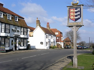
Winchelsea
Winchelsea to Hastings via Three Oaks walk
Feb-06 • Saturdaywalker on Flickr
swcwalks swcwalk316 banner 29740430008

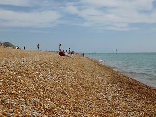
Fairlight Glen beach
Hastings to Winchelsea via Three Oaks walk
Aug-18 • Saturdaywalker on Flickr
swcwalk316 swcwalks walkicon 42720115690

Hastings old town
Winchelsea to Hastings via Three Oaks walk
Aug-04 • Saturdaywalker on Flickr
swcwalks swcwalk316 43563126812
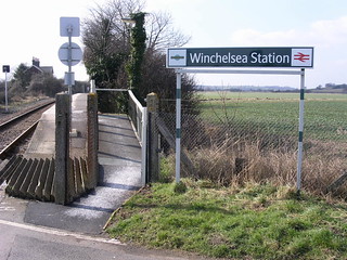
Winchelsea station
Winchelsea to Hastings via Three Oaks walk
Feb-06 • Saturdaywalker on Flickr
swcwalks swcwalk316 29740429888


Lower Snailham
Winchelsea to Hastings via Three Oaks walk
Jul-18 • Saturdaywalker on Flickr
swcwalks swcwalk316 29063425357
| Length | Full walk: 26.4km (16.4 miles) Winchelsea to Fairlight: 20.3km (12.6 miles) Winchelsea to Three Oaks: 12.9km (8 miles) Three Oaks to Hastings: 13.5km (8.4 miles) |
|---|---|
| Toughness | 8 out of 10 - gently undulating, but with three steep climbs towards the end. |
| OS Maps | OS Explorer 124 |
| Features |
This walk initially follows the 1066 Walk along an undulating ridge from Winchelsea to Icklesham, and then on into hilly territory with fine views on the southern edge of the Brede valley, before curving south to lunch at Three Oaks. The scenery is varied, consisting of a lot of pastureland and farms but with some woods. After lunch you head southwards through more pleasantly varied territory before climbing up the ridge, with increasingly extensive views, to Fairlight, where the Coastguard Cafe or the Grumpy Cook Cafe are possible tea options (reached by a minor diversion off the main walk route). The last section of the walk is the coastal route into Hastings, including three steep ascents and descents. There is the possibility of a swim in the sea (at your own risk: see below) at Fairlight Cove or in Hastings itself. This is walk is intended as GPX or map-led walk but some basic directions are also provided below to help you with navigation. For about two thirds of its length the walk follows the 1066 Walk and its link route to Hastings: this is reasonably well maymarked, but the signs are getting rather faded in many cases. Approaching Hastings, the coast path is easy to follow. |
| Walk options | Three Oaks has a railway station, 100 metres down the road from the pub, so it is possible to start or finish the walk here. Winchelsea to Three Oaks is 12.9km (8 miles), with a lunch stop at the Queen's Head in Icklesham and tea at the Three Oaks pub. Three Oaks to Hastings - 13.5km (8.4 miles) - is possibly the more interesting section, with the Coastguard Cafe and Grumpy Cook Cafe (reached by a minor diversion off the main walk route) as possible lunch options. It is also possible to finish the walk in Fairlight, 20.3km (12.6 miles) into the walk, using the 101 bus: see Transport below. This cuts out the strenuous ending of the walk, but you miss some very fine coastal scenery. If you are doing the whole walk but not planning to stop for tea or lunch at Fairlight, the Warren Glen shortcut reduces the walk by 1.2km (0.75 miles), eliminating a big descent and some ascent, but also cutting out some fine scenery. Alternatively, you can miss out the coastal ascents and descents by taking a higher route into Hastings, most of it along a quiet level lane following the 1066 Walk Hastings Link. See paragraph 38 of the Walk Directions below for details. |
| Swimming in the sea | The very picturesque Fairlight Glen, 21.1km (13.3 miles) into the walk, has a naturist beach, which is also one of the most unspoilt places on this part of the coast to swim (ie no modern development, just a shingle beach in a wild cove). The path down to the beach is officially closed due to landslips, but if you ignore this (at your own risk) you will find a trail that is usually well-maintained by the naturists. Swimming is good at high or low tide, but tricky when the tide is halfway up, due to rocks near the shore. Hastings at the end of the walk also has a good beach for swimming - the classic south coast combination of a steeply shelving shingle which retreats to flat muddy sand when the tide is very low. |
| Transport |
Take the Southeastern high speed trains from St Pancras International to Ashford International and change there for the hourly Marshlink trains to Winchelsea and Three Oaks. Obviously, given the length of this walk, the earlier you start the better. Note that the three or four-carriage Marshlink trains can become very crowded in the summer months. You need to be in the front carriage to alight at Three Oaks. Returning from Hastings, there are now quicker connections to London via the Marshlink line to Ashford International and then a high speed train to St Pancras. This takes 1 hour 26 minutes compared to 1 hour 44 minutes at best for the direct route to Charing Cross. However, the three or four-carriage Marshlink trains can get very busy at Rye in the summer months and the downside of the relatively short connection times at Ashford is that a delay to the Marshlink train can make you miss your high speed train, removing any time advantage. If you live in South London, Southern trains via Eastbourne and East Croydon (2 hours) may offer better connections. A day return to Winchelsea or Three Oaks is the same price from St Pancras as a Hastings return, though a Hastings return might be safer if returning via Ashford. If you plan to return via the Charing Cross line a Winchelsea or Three Oaks return will be valid, however, and you will also be boosting usage statistics to these remote stations by buying a ticket to them. The 101 bus runs roughly hourly along the main road past Fairlight village (the stop being at the far end of the road the Coastguard Cafe is in - see paragraph 39 of the Walk Directions) until around 6.30pm Monday to Saturday (5pm Sunday) to Hastings, and 7.15pm Monday to Saturday (5.30pm Sunday) to Rye (the opposite direction). Using this you can shorten the walk to 20km (12.4 miles). |
| Lunch and Tea |
The Queen's Head in Icklesham (01424 814552) is a very fine old pub with a garden with gorgeous views. It is only 5.3km (3.3 miles) into the walk, so perhaps too early a place to stop on the full walk, though for the short walk from Winchelsea to Three Oaks it is an ideally placed lunch stop. The Three Oaks pub (01424 8133013) is 12.9km (8 miles) into the walk and so is the best-placed lunch stop for the full walk. It is a quirky and comfortable place with armchairs and lots of decorative items on the walls. There is some outside seating. Food is served in enormous portions (you could almost share one meal between two...) all afternoon till 7.30pm Monday to Saturday and 6pm Sundays, and tea is served in pots, along with coffee. The popular Coastguard Cafe (01424 813373) in Fairlight (reached on a short diversion off the main walk route) was resurrected in 2021 after a period of closure, and now offers hot drinks, sandwiches, cakes and short-order meals from Tuesday to Friday, with a full hot meal menu at weekends; in each case it is open till 5pm. It is closed Mondays, apart from bank holidays. Both inside and outside seating available. (Opening hours seasonal, so check in winter). The Bale House, the new Hastings Country Park Visitor Centre in Fairlight (reached on a short diversion off the main walk route), has a Grumpy Cook cafe with both inside and outside seating, serving soups, paninis, jacket potatoes and pizza until 5pm daily. Hastings has lots of cafes, pubs and fish and chip shops. George Street in the Old Town, the first part of the town that you come to when you descend from the cliffs, being the best place to look for the more characterful establishments. |
| Profile | |
|---|---|
| Help Us! |
After the walk, please leave a comment, it really helps. Thanks! You can also upload photos to the SWC Group on Flickr (upload your photos) and videos to Youtube. This walk's tags are: |
| By Train |
Out (not a train station) Back (not a train station) |
| By Car |
Start TN36 4JX Map Directions Return to the start: Finish TN34 1BA Map Directions Travel to the start: |
| Amazon | |
| Help |
National Rail: 03457 48 49 50 • Traveline (bus times): 0871 200 22 33 (12p/min) • TFL (London) : 0343 222 1234 |
| Version |
Apr-24 Peter |
| Copyright | © Saturday Walkers Club. All Rights Reserved. No commercial use. No copying. No derivatives. Free with attribution for one time non-commercial use only. www.walkingclub.org.uk/site/license.shtml |


Walk Directions
These are not full walk directions, but notes designed to be used in conjunction with the GPX or an Ordnance Survey Map.
- Coming out of the Winchelsea station, walk south along the road.
- When you get to a junction with a major road, the 1066 route does a loop to the right, but it seems simpler to walk up the left-hand edge of the main road as it climbs the hill on an incline (there is just about enough verge to do this safely, but do take care nonetheless).
- At the top of the incline, fork off left off the main road through the medieval city gate into Winchelsea and then take the next road to the right up through the centre of the village. You now have a longish section on (largely quiet) roads. This takes you through the centre of Winchelsea and out the other side. Where the main road turns to the right, it is possible to take the footpath just to the right, which takes the 1066 route across the fields, but the road route followed by the GPX is arguably more scenic. That is to keep straight on at the turning down a side road to eventually pass through New Gate, an isolated old gate to the city of Winchelsea.
- You then come out onto a level section of road with a nice view of Romney Marsh to your left, before it starts to gently climb a hill. About 300 metres into this climb look out for a path diverging across a field to your left, heading for the corner of a wood.
- Follow this path around the edge of the wood and across fields to return to the road. You are only on this for a very short distance before the 1066 route diverges off to the right and up a hill with a windmill on top.
- Returning to the road after this hill, again you are on it only very briefly before the 1066 route diverges off to the right along a field edge.
- When this path comes to a tarmac drive, turn right, but not onto the drive itself but on a path to the left of it, which curves around the edge of fields, with houses to the right.
- Follow this path, ignoring ways off (though Icklesham church to the right later on the path is supposed to be worth a visit) to a road and turn right. At a major road junction take the lane directly ahead. At the end of this lane the Queen's Head is on the right, but your onward route is to carry on round to the left on the lane/track.
- After about 400 metres on the lane/track the path diverges off down across a field to your right. It follows the valley bottom for a while and then climbs up again to Brook Farm.
- Beyond Brook Farm, where the farm track turns left and becomes a lane, there should be a path straight ahead across the fields, but this seems to have fallen out of use. Instead take the lane to the left and then in 100 metres or so turn sharp right onto another farm track.
- This track takes you past Snaylham Farm, with increasingly fine views. Just before Lower Snailham Farm ignore a signposted footpath to the left, but just after turn left off the track down across a field.
- Pass through a metal gate in the bottom left-hand corner of the field, and beyond it turn right through a rough riverside area, with a stream to your left.
- After turning left across the stream at a signpost, the path keeps more or less to the field edge. In another 200 metres it veers right across the field to cross two footbridges, the second one bringing you into another field.
- Keep to the left-hand edge of this field to find a stile hidden under trees at its far end. Turn half left after the stile to the top left-hand corner of the field. The exit from the field is not obvious until you get to it: you pass through a fieldgate and on up a grassy track to Lower Lidham Hill Farm.
- Follow the track after the farm down to a public road and turn right. In 300 metres more, at the top of the hill, there is a side road on the right which leads to Doleham station.
- If you are interested in such things, a diversion to this remote halt, served by only three trains a day in each direction (all at wildly impractical times), is worth the effort: it is a charmingly unlikely place for a railway station. But it is a 250 metre walk down a fairly steep hill to get to it and you have to retrace your steps up to this point afterwards.
- Otherwise, ignoring the Doleham turning, in another 200 metres the road veers left, but the 1066 route goes straight ahead, emerging onto a rough hillside with lots of wildflowers in summer.
- Carry on down the hill to cross the wooded railway track at the bottom of the hill (with Doleham station just visible past the bridge to the right), and beyond it carry on across a field for 130 metres or so. On the far side cross a footbridge over Doleham Ditch and turn left.
- You are now on the left-hand edge of a huge field, which you follow that for about 600 metres. After that distance be alert for a stile/gate to the left, which takes you through the field boundary and out a fenced path between fields. In 250 metres you emerge onto the right-hand edge of another field
- At the far end of this field there is a house: just past it you turn left on a track, which goes up into the woods and curves right.
- When the track comes out of the woods, your onward path is very sharp left, back into the wood and across the railway line again. Beyond keep more or less straight ahead up across two fields.
- Entering a third field at the top of the hill, fork right to descend to a gap by a mini-pylon post. Keep on up across the next field and then in the field after that turn right at three-armed footpath sign. Following this to the far end of the field you emerge right by the Three Oaks pub. To end the walk here, turn left past the pub and then turn right on the road beyond the pub to find Three Oaks station in 100 metres.
- Turn left out of the Three Oaks pub or turn right out of the station and follow the road north eastwards. Where the village peters out you are looking for a path slanting right across the fields. In the far corner of the field this veers right and follows the left-hand edge of two fields into a wood, passing through it to a main road.
- Turn right on the main road (there is a pavement). At the next road junction turn left up a side road. There is soon a path through the trees to the left of the road, parallel to it. Follow this to Guestling Church.
- Pass through the churchyard. Beyond it, your path is the one going right, downhill across a field towards a wood.
- In the wood, keep to the main path straight ahead, passing a footpath post marking a fork to the right in 200 metres. In another 100 metres there is another post; here fork right with the 1066 Link Route. Climb steadily up this path to the edge of the wood.
- Leaving the wood, go up the right-hand side of a field and enter the yard of a house. Go through the gate/stile on its far side, and turn right along the very bottom of a rough field, ignoring a path slanting up across it.
- This path brings you through a gate and out onto a lane, where you turn left for 40 metres. Then, when it turns left, veer right off it (more or less straight ahead) onto a path. In 100 metres you come to another lane, which you cross this and carry on along the left-hand edge of a wood (which has wood anemones in late March and early April).
- When you get to another road, turn left on it and then right on a main road, taking care of the traffic. You have to walk a short and slightly awkward section on this main road, but there is a good grass verge to the left.
- When you get beyond the houses, look out for a path into a field to the left. The route across this field is not clear, but slant up the hillside and keep going in that direction and you come to a metal gate, hidden by the curve of the hill and reached by a few steps down. If you come to gates marked PRIVATE, you are a little to the right of where you should be: turn left along the field boundary to find the metal gate mentioned in the previous sentence.
- Pass through the gate and slant diagonally right down across the field to pass into another field in its far corner. Carry on along the bottom of this, with a fence to your left.
- Continue across the fields to a track, cross it, and beyond it fork left across a rough area down to footbridges.
- After the footbridges you emerge into a field with a stream marked by a line of trees ahead. Cross this and turn right uphill, with the stream/trees to your right.
- Where the tree boundary eventually turns decisively right, a path goes straight across the field to your left, to come to a stile into a wood. The fine house to your left is Fairlight Hall.
- Once in the wood (some bluebells here in late April or early May), curve right uphill to come to another path and turn left on it. Follow this path through woods and into occasional open sections, with fine views to the left. Near the top of it there are a few short sections which are rather overgrown with brambles and thistles in high summer (though in June 2023 it was relatively clear).
- Eventually you come up to a main road. Veer slightly left across this to find track beyond, almost immediately turning right onto a broad grassy strip parallel to the road. In 150 metres turn left through a kissing gate up a footpath on the edge of a field. There is a fine view of the sea ahead.
- In 200 metres, at the end of the field, there is a crosspaths, where there are four choices:
- To do the short cut down to the end of Warren Glen, reducing the walk by 1.2km (0.75 miles), turn right here and then in 10 metres, after a kissing gate, turn left onto a fenced path leading downhill, with a wood boundary to your right and a field to your left. At the bottom of the hill, turn right onto the coast path. You are now climbing out of Warren Glen and can follow the directions in paragraph 42 below.
- For the higher route into Hastings, cutting out the ascents and descents of the coast route (but also missing out on some fine scenery), turn right at the crosspaths. Follow a path across fields, to eventually emerge onto a track, which later becomes a quiet road, passing a caravan site. Once you get to the outskirts of Hastings, with suburban houses on your right, look out for a left fork which the 1066 Walk Hastings Link follows to take you over a headland and down into the old town, with fine views.
- For the Grumpy Cook Cafe and Coastguard Cafe, adding 230 metres and 600 metres to the walk respectively, and also to end the walk by taking the bus from Fairlight, turn left at the crosspaths in paragraph 36 and in 150 metres pass through two kissing gates. 15 metres after the second kissing gate, cross a gravel track leading to a bungalow (hidden by hedges to the right). In another 40 metres, at a slanted crosspaths, fork left onto a more minor path. In 250 metres this brings you out into a former quarry, a flat area dotted with gorse. Follow the main path through this. In 300 metres, at the end of the quarry, this narrows between rocky sides and scrub, and then climbs a short flight of steps. After the steps, turn left at a fork/T-junction. This brings you up to a broad path between fields, and then in 150 metres to a road with a car park nearby. The Bale House (the Hastings Country Park Visitort Centre) with the Grumpy Cook Cafe is to the left here (and behind it there is a water tap if you need to refill your bottles). For the Coastguard Cafe turn left past the visitor centre and in 20 metres fork right up a path which almost immediately becomes a suburban road. In 150 metres the cafe is on the right. Staying on the road, in another 200 metres you come to a T-junction with a main road. The bus stop for buses to Hastings is on this side of the main road and to Rye on the opposite side. To continue the walk after lunch or tea from the Coastguard Cafe, return down the road to the visitor centre, and then follow the minor road seaward (that is, turning left on the road in front of the visitor centre if coming from the Coastguard Cafe, and turning right on it if coming out of the visitor centre) to join (and turn right onto) the coast path just beyond a set of cottages and a radar station. Continue with paragraph 42 below.
- To carry on along the main route, turn left at the crosspaths in point 36. In 150 metres pass through two kissing gates. 15 metres after the second kissing gate cross a gravel track leading to a bungalow (hidden by hedges to the right). In another 40 metres ignore a minor path forking left and another to the right. Keep straight on with fine sea views, until you come to a road. Turn right on this and just past some cottages and a radar station you come to the coast path, where you turn right.
- Once on the coast path, the route is then easy to follow down into Warren Glen and up and over into Fairlight Glen. At the wooded bottom of the latter, signs warning you not to take the path down to the beach show you the location of this path: see Swimming Notes above.
- After the steep climb out of Fairlight Glen there is a flat section on the cliff top. Eventually this brings you to Ecclesbourne Glen, which you descend into steeply on the coast path. Climbing out of it, you emerge onto the flat grassy expanse of East Hill, with Hastings visible beyond. Descend to the town via the tarmac path that starts by the upper station for the East Hill Lift.
- Once in Hastings, it is still worth following the GPX, firstly to descend to the seafront via the delightful Tamarisk Steps, then to follow George Street through the heart of Hastings' Old Town.