Route Finding
Using a map
For the purpose of this short guide, all examples are based on a 1:25000 scale map. (The OS Explorer series, recommended for walkers.)
Scale: For a scale of 1:25000, each unit on the map is equivalent to 25000 units on the ground.
Thus 1cm is equivalent to 25000cm (250 metres) on the ground, and it follows that:
- 1cm is equivalent to 25000cm (250 metres) on the ground.
- 4 cm is equivalent to 100000cm (1000 metres = 1 kilometre) on the ground.
- The blue grid lines on the map form 1km squares, allowing you to quickly and roughly calculate distances between points.
An easy example of planning a short circular walk using an OS map.
In this example an anti-clockwise walk from Beenham has been planned. The map on the right shows the planned route (marked in yellow), with the reference points in the text below also marked.
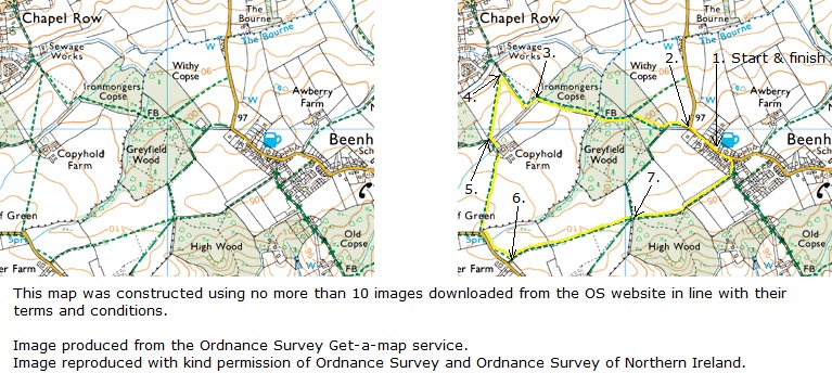
Leaving The Six Bells pub at Beenham, turn right along the road in a north-westerly direction. In 200m (2.) where the road turns sharp right look out for a bridleway forking left off the lane. This turns out to be along a farm track. [Closer view of the track forking left: note the (bridleway) path signpost in bushes on the right-hand side of the track.]
Your direction across the field towards the corner of the wood (marked Greyfield Wood) will be ~west. Upon reaching the eastern most corner of the wood, you will probably have to cross over a stile or go through a gate to enter the wood to continue, direction 280°, for ~300m through the wood to then go over a footbridge (marked FB on the map) and continue in the same direction on the footpath along the southern edge1 of Ironmongers Copse.
After ~250m you reach the edge of the Copse, (3.) to emerge from the wood into a field.2
At (4.) you reach a path junction3 where you turn sharp left (partly back on yourself) crossing into a field on your left to now head in the direction 190° across the field. At this point looking south, you may also be able to see the buildings of Copyhold Farm.
After 300m having crossed the field, you reach a path junction (5.) and veer left, direction 160° for 50m (with Copyhold Farm on your left), and then veer right to continue in your prior direction 190° across a field.
After 350m the footpath comes out onto a road, where you turn left along the road in a south-easterly direction. After ~130m fork left off the road onto a footpath running parallel to the road.
In 100m at a path junction (6.) turn left to go across two fields, your direction 80°. In 600m you reach a path junction at the north-west corner of High Wood (7.)
Continue along the footpath along the border of the field on your left and High Wood on your right. In 250m at the northern most tip of High Wood, follow the footpath across fields, your direction now 70°. After 250m the footpath joins a byway where you veer left to head north back into Beenham. In 50m at a T-junction with the main road turn left along the main road to reach your starting point, The Six Bells pub, Beenham.
Footnotes
- The footpath is along the left (southern) side of the wood. On your left (south) beyond the wood boundary is a field. You should also be able to make out the buildings of Copyhold Farm (as shown on the map) to the south west.
- At this point the offical definitive footpath is to the left along the left edge of the field. The black dotted line indicates an alternative common route, this is not the offical footpath, but it may now be in more common usage.
- At this junction you'll note a brown contour line intersecting on the map. Following this line to the right, you'll see that it is marked 100 (metres above sea level) at the point where the line crosses the north-east boundary of Greyfield Wood. Further south 5mm on the map (equivalent to 125m on the ground) the next contour line is marked 105, thus going along this footpath for 125m you will go slightly uphill - ascending 5m over a distance of 125m. OS worked example using contours.
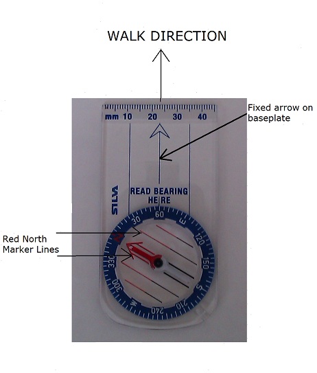
Taking a compass reading
- Align the fixed arrow on the base plate of the compass in the direction that you intend to walk.
- Hold the compass at waist level, (ensuring you are clear of any metal objects such as a metal fieldgate that could affect the reading) and allow the needle to settle.
- Turn the rotating face so that the red north marker lines up with the red needle.
- With the arrow on the base plate pointing towards the direction that you intend to walk, you can now read off the bearing.
The compass reading for the picture below is 60 degrees.
Paths
In Britain there are four main types of public rights of way.
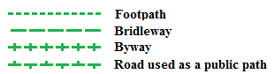
1. Footpath
This public right of way is for walkers only. (Marked on Ordnance Survey (OS) maps as short green dashes. Ref.: Legend below.)
2. Bridleway
This public right of way is for walkers, horse-riders and cyclists only. (Marked on OS maps as long green dashes. Ref.: Legend above.)
3. Byway
(Short for 'Byway open to all Traffic', or BOAT). This public right of way is for all: Walkers, horse-riders, cyclists and motorised vehicles (commonly farm vehicles and motor bikes). (Marked on OS maps as long green dashes with a bar across it. Ref.: Legend above.) Originally byways were established (prior to motorised vehicles) as highways to be used by horses and carts. With the introduction of motorised vehicles use of a byway was extended to include them. Unfortunately where the surface of the byway is not tarmacked it can easily become damaged, particularly during the winter months in muddy conditions. It is for this reason that some byways now have seasonal access for non-essential motorised vehicles.
4. Road Used as a Public Path or RUPP (Now redesignated as 'Restricted Byway' )
RUPPs or Restricted Byways provide a right of way for walkers, horse riders, cyclists and other non-mechanically propelled vehicles.
Permissive / Permitted Paths
Use of these is permitted by the landowner, but they are not public rights of way and the landowner may withdraw permission. They are shown on OS maps as short orange dashes for permissive footpaths and long orange dashes for permissive bridleways.
National Trails
National Trails are long distance paths along public rights of way in England and Wales. The idea for National Trails came about after the Second World War, whereby a long distance route could be established by linking various well established (and some newly created) paths, consisting of footpaths, bridleways, byways and minor roads. They are marked with an acorn symbol on the waymarks along the route. The South Downs Way, North Downs Way, The Ridgeway and The Thames Path in the south east of England are all National Trails.
Currently there 15 National Trails in England and Wales. The first ever National Trail was The Pennine Way which was designated in 1951 and officially opened on 24th April 1965.
Access Land
Not all access to the countryside in England and Wales is restricted to defined paths, however. Land managed by the National Trust, the Forestry Commission and the Woodland Trust have long been open for access on foot anywhere. Moreover, since 2005 when the provisions of the Countryside and Rights of Way (CroW) Act 2000 came into force, 936,000 hectares of mountain, moorland, heath and other unenclosed land (shown on the map in yellow), much of which had been used for shooting and other 'field sports' and from which walkers had been excluded, have been available to walk on.
Access to coast and foreshore
This remains patchy, and is by no means universally available around the coast. However the Marine and Coastal Access Act 2009 enabled the creation of a national trail around the whole coastline of England and Wales. To date, the Welsh coastal path has been completed but in England halting progress only is being made in creating stretches of path to link the existing national trails (eg the South West Coastal Path and the Cleveland Way).