Waterlink Way : Lower Sydenham to Greenwich walk
Follows the Pool and Ravensbourne rivers through south east London via landscaped linear parks and green spaces

Waterlink Way Waymarker Disc
SWC Short Walk 36 - Waterlink Way (Lower Sydenham to Greenwich)
Feb-19 • thomasgrabow on Flickr
swcwalks short36 banner 40455202103
![Beckenham Place (Pallatian Mansion) SWC Short Walk 36 - Waterlink Way (Lower Sydenham to Greenwich) [Ravensbourne Start]](https://live.staticflickr.com/7882/46505549495_a5e0c91a2c_n.jpg)
Beckenham Place (Pallatian Mansion)
SWC Short Walk 36 - Waterlink Way (Lower Sydenham to Greenwich) [Ravensbourne Start]
Feb-19 • thomasgrabow on Flickr
swcwalks short36 walkicon 46505549495

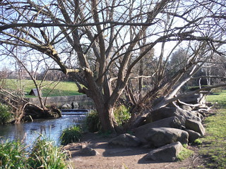
Boulders and Weir on River Pool, The Riverview Walk, Sydenham
SWC Short Walk 36 - Waterlink Way (Lower Sydenham to Greenwich)
Feb-19 • thomasgrabow on Flickr
swcwalks short36 walkicon 40455198993

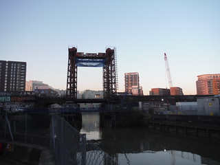
Ha’penny Hatch footbridge, Deptford Creek
SWC Short Walk 36 - Waterlink Way (Lower Sydenham to Greenwich)
Feb-19 • thomasgrabow on Flickr
swcwalks short36 walkicon 47420840441

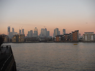
Canary Wharf across The Thames
SWC Short Walk 36 - Waterlink Way (Lower Sydenham to Greenwich)
Feb-19 • thomasgrabow on Flickr
swcwalks short36 walkicon 46697618914

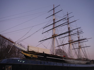
Cutty Sark
SWC Short Walk 36 - Waterlink Way (Lower Sydenham to Greenwich)
Feb-19 • thomasgrabow on Flickr
swcwalks short36 walkicon 47420836191
![Waterlink Way Sign, South Norwood Country Park/Elmers End Road SWC Short Walk 36 - Waterlink Way (Lower Sydenham to Greenwich) [Arena Start]](https://live.staticflickr.com/7867/40455168913_7008af80a5_n.jpg)
Waterlink Way Sign, South Norwood Country Park/Elmers End Road
SWC Short Walk 36 - Waterlink Way (Lower Sydenham to Greenwich) [Arena Start]
Feb-19 • thomasgrabow on Flickr
swcwalks short36 40455168913
| Length |
9.7 km (6.0 mi) Ascent: negligible. For a shorter or longer walk, see below. Time: 2 ¼ hours walking time. |
|---|---|
| Walk Notes |
The route connects a number of attractive parks and green spaces in South East London, while following the Pool and Ravensbourne Rivers. It follows parts of the well-waymarked Waterlink Way, the London-part of the National Cycle Network Route connecting Eastbourne to the Thames. Large stretches of those rivers have in recent years been re-naturalised or at least sympathetically embedded in landscaped linear parks such as Ladywell Fields and Brookmill Park, and as such the route makes for a pleasant outing in a densely populated part of London, even though some formerly highly industrialised areas such as Deptford as well as some densely built-up areas such as Catford and Lewisham are passed through. The Waterlink Way is a shared cycle-/footpath all the way through and as such avoids public footpaths. The route described diverts from the waymarked route where a better alternative for walkers exists. The parks walked through generally close around dusk. If in doubt, check the respective council websites. |
| Walk Options |
The walk route runs past a few railway and DLR stations (Catford/Catford Bridge, Ladywell, Lewisham, Elverson Road and Deptford Bridge), enabling an earlier finish or later start. The Waterlink Way goes through some attractive walking terrain even further south than Lower Sydenham, i.e. South Norwood Country Park, where it follows one of the Pool River’s tributaries, and Cator Park and it also has a spur from further up the Ravensbourne in pretty Beckenham Place Park. But while largely leading through green spaces, these routes contain a fair amount of road walking through residential areas and/or industrial estates and are therefore not part of the main walk. Nevertheless, starts from railway or tram stations along, or close to, those routes (Arena, Ravensbourne, Kent House, Beckenham Road and Clock House) are described, adding between 2.0 km and 5.1 km to the total distance. |
| Travel |
Lower Sydenham station is located in Zone 4 and served by Southeastern trains on the Mid-Kent line, which branches off from the South Eastern Mainline at Lewisham and leads to Hayes. Some trains start at Cannon Street (via Lewisham), others at Charing Cross (by-passing Lewisham). Travel time is 24 minutes from Charing X and Cannon Street and 15 or 20 minutes from London Bridge. |
| Notes |
Waterlink Way The Waterlink Way is a cycle-path and walking route in South East London, following the Pool and Ravensbourne rivers while connecting a number of parks and green spaces – including Ladywell Fields and Brookmill Park. A Beckenham Place Park spur from further up the Ravensbourne River starts at Ravensbourne station and leads across Beckenham Hill, the watershed to the Pool river, and on to Lower Sydenham. It is an established part of the National Cycle Network Route 21, linking Eastbourne to the Thames and well waymarked. The route was designed to be accessible, with a large number of railway and tram stations en route, in SE London including Kent House, Clock House, Lower Sydenham, Ladywell, Lewisham and Greenwich. In Cator Park, Beckenham it links with the Capital Ring and Green Chain Walk. Find a map here: https://lewisham.gov.uk/inmyarea/sport/get-active/walking/waterlink-way South Norwood Country Park South Norwood Country Park is one of the largest open spaces in the Borough of Croydon and was only created at the end of the 20th century. The 47 hectares (116 acres) park is a mix of countryside, parkland, and land formerly used for sewage farms serving London (largely unsuccessfully because of the heavy London Clay subsoil). These days it has lakes, a visitor centre, a children’s playground and plenty of paths. With a wide range of different habitats, the country park is a haven for wildlife and a Local Nature Reserve. Ravensbourne River The River Ravensbourne is a 17 km (11 mi) long tributary of the Thames in south London. It flows through the Boroughs of Bromley, Lewisham and Greenwich and enters the tidal River Thames at Deptford, where its tidal reach is known as Deptford Creek. The Ravensbourne rises at Caesar's Well, Keston, 6 km south of Bromley town centre. For the initial third of its length the river flows across common land (including Hayes and Bromley Commons) until it reaches the southern outskirts of Bromley town where it is joined by the Ravensbourne South Branch and the Ravensbourne East Branch, which substantially increase the flow. Its main tributaries are the Pool (joining in Catford), and the Quaggy (joining in Loampit Vale, Lewisham). Pool River The River Pool is a 5 km (3 mi) long tributary of the River Ravensbourne, rising with its tributaries The Beck and the Chaffinch Brook between Addiscombe and West Wickham in Croydon. It is called ‘Pool’ from the confluence of these tributaries in Cator Park and then flows northwards through Beckenham and Sydenham, to join the Ravensbourne in Catford. For much of its length the river lies in a floodplain and at Sydenham, a section of the river that ran in a culvert under some gas works has been opened up and landscaped. Beckenham Place Park Beckenham Place Park is Lewisham Borough's largest green space, extending to 96 hectares (237 acres) and including a wide range of facilities, including a lake, ball court, football pitches, tennis court and sensory garden. It was established between 1757/60 and 1785 by John Cator the Younger who had acquired the rights of the Manor of Beckenham. The park is named after Beckenham Place, a Palladian-style mansion which now serves as a community centre and café. A railway line splits the park into two distinct parts and the only routes from one part to the other are at the northerly and south easterly ends. These days the park is a Local Nature Reserve and a Site of Metropolitan Importance for Nature Conservation and the Green Chain Walk and Capital Ring run through it. It is considered one of the finest wildlife sites in the borough, containing ancient woodland as well as a variety of other habitats. https://en.wikipedia.org/wiki/Beckenham_Place_Park https://www.beckenhamplace.org/ |
| Eat/Drink |
All Ladywell options: about 4.5 km from the start.
Plenty of other options in Greenwich - near and just beyond the end; see text below for details. |
| Profile | |
|---|---|
| Help Us! |
After the walk, please leave a comment, it really helps. Thanks! You can also upload photos to the SWC Group on Flickr (upload your photos) and videos to Youtube. This walk's tags are: |
| By Train |
Out (not a train station) |
| By Car |
Start SE26 5BN Map Directions Finish Greenwich Map Directions |
| Amazon | |
| Help |
National Rail: 03457 48 49 50 • Traveline (bus times): 0871 200 22 33 (12p/min) • TFL (London) : 0343 222 1234 |
| Version |
Apr-24 Thomas G |
| Copyright | © Saturday Walkers Club. All Rights Reserved. No commercial use. No copying. No derivatives. Free with attribution for one time non-commercial use only. www.walkingclub.org.uk/site/license.shtml |
Walk Directions
Full directions for this walk are in a PDF file (link above) which you can print, or download on to a Kindle, tablet, or smartphone.
This is just the introduction. This walk's detailed directions are in a PDF available from wwww.walkingclub.org.uk

