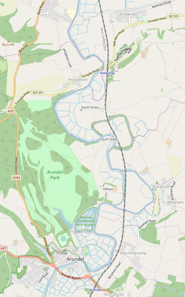
Amberley Circular via Arundel Park Walk
A walk through Arundel Park to an attractive old town with a castle and cathedral, returning along the Arun Valley.
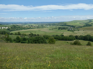
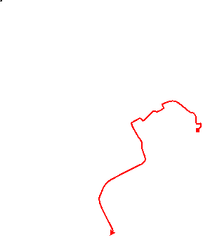
View towards Amberley from Arundel Park
Amberley Circular via Arundel Park walk
Jun-21 • Saturdaywalker on Flickr
swcwalks swcwalk361 banner 51278832132
| Length |
Main Walk: 18¼ km (11.3 miles). Four hours 25 minutes walking time. For the whole excursion including trains, sights and meals, allow at least 10 hours. Alternative Walk, finishing at Arundel: 14¾ km (9.2 miles). Three hours 35 minutes walking time. Short Circular Walk, omitting Arundel: 14½ km (9.0 miles). Three hours 30 minutes walking time. |
|---|---|
| OS Map |
Explorer OL10 (previously 121). Amberley, map reference TQ026118, is in West Sussex, 5 km N of Arundel. |
| Toughness |
5 out of 10 (4 for the Alternative Walk, 3 for all the Short Walks). |
| Features |
There are many attractive walking routes where the River Arun cuts through the South Downs from Amberley to Arundel and much of this walk will be familiar to those who know the classic Arundel to Amberley walk (1–32). This walk starts with a short loop through water meadows to Houghton and a stretch alongside a sweeping curve of the river below the wooded downs. It then goes across the downs and past Swanbourne Lake in Arundel Park, before a long loop around more water meadows into a town with no shortage of possible lunch places. The second half of the walk includes another section through the landscaped parkland, and ends with an undemanding stroll up the river valley to Amberley station. Arundel Park is closed to the public on March 24th each year, but the directions follow rights of way through the park and these should remain open. The centrepiece of the walk is the attractive hilltop town of Arundel, its skyline dominated by the massive castle and ornate Roman Catholic cathedral. The principal seat of the Dukes of Norfolk, Arundel Castle is open to the public from April to October; admission is from £15 to £29 (2024). Arundel's parish church of St Nicholas and the Cathedral Church of Our Lady and St Philip Howard are both well worth a visit, and the hamlets of South Stoke and North Stoke each contain unusual old churches. Arundel and Amberley have contrasting museums which you could visit. In a new building near the town bridge, Arundel Museum is a small museum of local history, open daily (except around Christmas); admission is £5 (2024). The much larger Amberley Museum and Heritage Centre exhibits the industrial heritage of south-east England on the site of an old chalk quarry next to Amberley station. It is open most of the year on Wed–Sun & BH Mon; admission is £17 (2024). The walk route also passes the Arundel Wetland Centre, managed by the Wildlife and Wetland Trust and open all year (except Christmas Day); admission for non-WWT members is about £15 (2024) but there is usually a 2-for-1 offer on the train companies' Days Out Guide. If the River Arun overflows its banks the stretches of this walk through the surrounding water meadows will be problematic, to say the least. |
| Walk Options |
Arundel is an interesting town and several shorter options allow more time to explore it or visit one of its attractions. The afternoon loop through Arundel Park is only 1 km from the town when it reaches Swanbourne Lodge, so for an Alternative Walk you could return along Mill Road and then finish at Arundel station. Another option would be to omit the morning loop through Arundel, with a riverside pub at Offham providing the lunch stop. A Short Circular Walk (with two possible endings) could be combined with a visit to Amberley Museum, while looping back to Arundel on a Short Alternative Walk would be convenient for visiting the Wetland Centre or spending time at one of the town's festivals. |
| Additional Notes |
A shorter version of the Main Walk was originally one of the two Circular Walks in this walk's companion, the revised and renamed Arundel Circular walk (#100). |
| Transport |
Amberley and Arundel are on the Arun Valley line, with a half-hourly service from Victoria (hourly on Sundays) taking around 1 hour 20 minutes to Amberley. On all the walk options buy a return to Amberley; on the Alternative Walks you would also need a single from Arundel back to Amberley but this combination is actually cheaper than a return to Arundel. There is no public transport to the hamlets between Arundel and Amberley, so you would need to persuade a taxi to venture down one of the narrow country lanes if you wanted to abandon the walk and were too far away from one of the stations. If driving, there is a very small free car park “for rail users” at Amberley station (the large car park is for visitors to Amberley Museum and is locked soon after it closes). |
| Suggested Train |
Take the train nearest to 09:40 from Victoria to Amberley. |
| Train Times |
|
| River Levels |
|
| Lunch |
On the Main Walk options there are many pubs, cafés and restaurants to choose from in Arundel (after 9½ km) and large groups might do well to disperse among them. The route into the town passes the Waterside Café (07779-930236), a popular place with an enviable riverside setting. In the High Street the three main establishments are the Swan Hotel (01903-882314) at #27-29, the Norfolk Arms Hotel (01903-882101) at #22 and the Red Lion pub (01903-882214) at #45. More idiosyncratic (but less food-oriented) pubs can be found in the side streets away from the town centre, and another possibility is St Mary's Gate Inn (01903-883145) on the route out of the town. The Short Walk options bypass Arundel and head upstream to the Black Rabbit (01903-882638) at Offham, reached after 7¾ km. This popular Hall & Woodhouse pub with its enviable riverside setting could also be a late lunch stop on the Main Walk. |
| Tea |
On the Circular Walks you have a choice of the terrace gardens at Riverside South Downs (01798-831066; Apr–Sep open to 5pm daily; Oct–Mar to 4pm Wed–Sun, closed Mon & Tue) or an attractive country pub with a beer garden, the Bridge Inn (01798-831619; closes at 5pm Sun & BH; closed all day Mon, Tue and the Wed after a BH Mon). These are on opposite sides of Houghton Bridge, very close to Amberley station. As mentioned above there is a wide range of refreshment places near the end of the Alternative Walks, where every other establishment in the centre of Arundel seems to be a hotel, pub, tearoom or café of some description. On the ten-minute walk to the station you also pass the White Hart pub (01903-884422). The café at Swanbourne Lodge and the Black Rabbit pub are both well-placed for a mid-afternoon break on the longer walks, and there is also a café serving visitors to the Wetland Centre. |
| River Levels |
River Arun (North of Arundel) River Arun (South of Amberley) |
|---|---|
| Profile | |
| Help Us! |
After the walk, please leave a comment, it really helps. Thanks! You can also upload photos to the SWC Group on Flickr (upload your photos) and videos to Youtube. This walk's tags are: |
| By Train |
Out (not a train station) Back (not a train station) |
| By Car |
Start Map Directions |
| Amazon | |
| Help |
National Rail: 03457 48 49 50 • Traveline (bus times): 0871 200 22 33 (12p/min) • TFL (London) : 0343 222 1234 |
| Version |
Jul-24 Sean |
| Copyright | © Saturday Walkers Club. All Rights Reserved. No commercial use. No copying. No derivatives. Free with attribution for one time non-commercial use only. www.walkingclub.org.uk/site/license.shtml |


Walk Directions
Click the heading below to show/hide the walk route for the selected option(s).

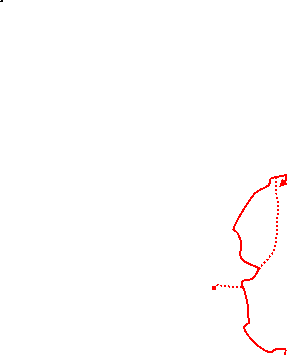


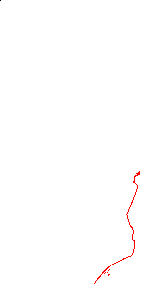
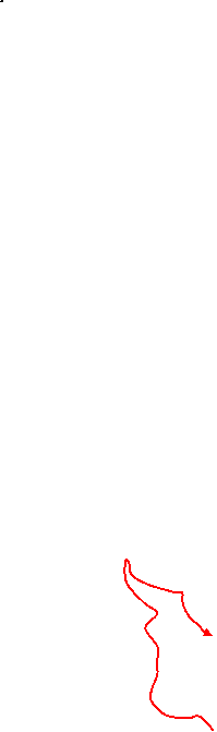

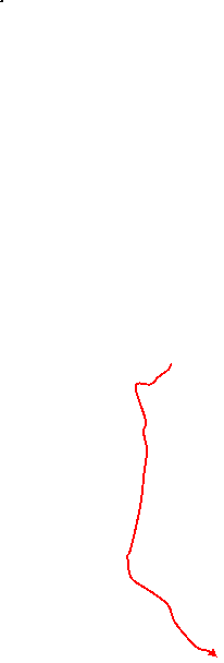
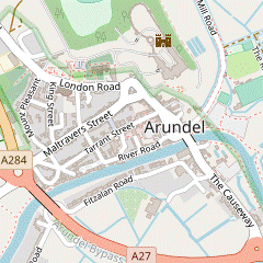
 Walk Map
©
Walk Options ( Main | Short )
Click on any option to show only the sections making up that route, or the heading above to show all sections.
- Main Walk (18¼ km)
Walk Directions
Click on any section heading to switch between detailed directions and an outline, or the heading above to switch all sections.
- Amberley Station to Arundel Park (3¼ km)
- Go down to the B2139 and turn left under the railway bridge. Turn right onto a footpath which leads to an embankment alongside the River Arun. Cross the river on the South Downs Bridge and follow the SDW as far as Houghton Lane. Turn left and go along the lane into Houghton village. Cross the B2139 and go down South Lane, joining the Monarch's Way (MW). Continue on a bridleway going alongside the River Arun for 1¼ km. Just after the path turns away from the river, go through a gate into Arundel Park.
- Leave the station at the London end of the platform. Go down its approach road and turn left onto the B2139. After passing under the railway bridge turn right onto a signposted footpath, a gravel track which leads to a grassy path past a cluster of park homes. At the end climb onto a low embankment to continue alongside the River Arun?, heading towards a substantial footbridge.
- In 250m keep ahead where the South Downs Way? (SDW) joins from a track on the right; you will be following this well-waymarked trail to Houghton Lane. At the South Downs Bridge cross the river to continue on the other bank. In 150m, where the river turns right, veer left off the embankment at a three-way footpath signpost.
- Go through a wooden gate onto a slightly raised grassy path alongside a ditch. In 200m zig-zag right and left as indicated and go through another gate. Follow the path gently uphill alongside a wire fence. At the end turn left onto Houghton Lane, leaving the SDW.
- After passing some farm outbuildings in a dip the lane climbs past an attractive thatched cottage and comes to a T-junction with the B2139 in the small village of Houghton. Cross the B2139 carefully (slightly to the right) and go down South Lane, passing more attractive old cottages and joining the Monarch's Way? (MW).
- At the bottom of the lane continue on a track curving gently round to the right. Go through a side gate onto a signposted bridleway along the right-hand side of a small open area. Keep right where a footpath joins from the left to continue along the bridleway, with the River Arun just off to the left.
- The path goes below a wooded cliff for 750m, with some potentially boggy stretches if the river has overflowed. After gradually curving round to the left it continues for a further 500m along a narrow strip between the river and a solid flint wall, the boundary of the Arundel Park estate.
- The path eventually turns away from the river and comes to a high metal kissing gate in the wall. Turn right through the gate to enter Arundel Park.
- Through Arundel Park to Swanbourne Bridge (3¼ km)
- Follow the waymarked footpath up a long ascent, then gently downhill into Swanbourne valley. Turn left along the valley floor (leaving the MW) and fork right onto a footpath going along the southern side of Swanbourne Lake.
- Inside the park turn left to go alongside the boundary wall, the start of a long ascent. In 100m the path turns half-right, away from the wall. In a further 250m turn half-right again as indicated onto a broad track. In 100m fork left towards another footpath signpost and follow the track up and round to the left, now heading S and climbing even more steeply.
- After a long climb, with fine views of the route from Amberley over your left shoulder, you come to a fieldgate. Go through the wooden kissing gate on its right and continue in much the same direction towards the right-hand edge of a small wood ahead.
-
As you reach the trees and the ground finally levels out, bear right to go alongside the wood on a chalky track. In 150m (and well before you reach a fieldgate) bear right off the track as signposted. Follow a faint grassy path towards a small clump of trees, to start a long and gradual descent.
There is a distant view of the sea ahead and you might also be able to see Hiorne Tower, 1½ km away.
- Go through a wooden kissing gate near the right-hand end of the trees and continue along the grassy path for about 750m, passing to the left of another clump along the way. After another gate the path drops down steeply to a major path junction at the bottom.
- Bear left onto a broad grassy track along the valley floor, leaving the MW and Walk 1–32 route. The track curves gently round to the left and in 150m comes to a three-way footpath signpost where you fork right onto a faint grassy path, which gradually diverges from the track.
- In 200m go over a stile and keep ahead on the perimeter path alongside Swanbourne Lake?, with the steeply wooded Mill Hanger on your right. At the far end of the lake follow the path out between wooden fences, crossing the outflow from the lake and passing some estate outbuildings off to the right on the site of the old mill.
- Outside the grounds of Arundel Park fork right to join Mill Road by Swanbourne Bridge. Take the signposted footpath on the left-hand side of the bridge, going down a few steps and across a side channel.
- Swanbourne Bridge to Arundel High Street (2¾ km)
-
 Take a footpath along the left-hand side of the mill-stream to the River Arun. Turn right onto the embankment and follow the riverside path on a long loop into Arundel. Go up the High Street into the town square.
- Do not cross the main channel but take the path heading away from the road bridge, with the tree-lined mill-stream on your right. In 500m the footpath comes out onto the bank of the River Arun. Turn right to cross the mill-stream on a sluice gate.
- You now simply follow the riverside path along the top of the embankment for 2 km. At first it curves left to head E and then makes a wide loop round to the right, with fine views of Arundel across the water meadows. The path eventually swings right to cross a small inlet and goes alongside the town's main car park.
-
The most direct route to the town centre is to stay on the riverside path, past the entrance to the Waterside Café and through a small riverside garden containing the ruined walls of Blackfriars?.
- Make your way to the mini-roundabout at the end of Mill Road, by the town bridge. There are several cafés and tearooms in the vicinity and the Swan Hotel can be reached by continuing a little further alongside the river.
-
For other refreshment places, go up the High Street on the right directly into the main square. The prominent Norfolk Arms Hotel is ahead on the right-hand side, with the Red Lion pub opposite. There are more refreshment places dotted around the square and along Tarrant Street, just beyond the Red Lion.
- Arundel High Street to Swanbourne Lodge (3½ km)
- Go up to the top of the High Street, rejoining the MW in the opposite direction. Turn right into London Road, passing the parish church and the Cathedral. Turn right onto a right of way through Arundel Park, passing Hiorne Tower and going down a long slope. Turn sharp right along the valley floor, leaving the MW and repeating a short stretch of the outward route. This time, keep left at the footpath junction to go along the northern side of Swanbourne Lake. At Swanbourne Lodge go out onto Mill Road.
- Make your way up the steep High Street?, alongside the castle wall. Follow the road round to the left by a gatehouse and keep right at a junction to stay alongside the castle wall. On this street (London Road) are two churches which are well worth visiting: the unusual parish church of St Nicholas? on the right, followed by the ornate Roman Catholic Cathedral? on the left.
- Beyond the cathedral you pass St Mary's Gate Inn and a primary school on the left. At the end of the school veer right across a small patch of grass, still alongside the castle wall. Cross a driveway leading to the Norfolk Estate Office to continue in the same direction along another estate road. In 200m you go through a gate into Arundel Park.
- The right of way continues along the estate road ahead for almost 500m (where a footpath signpost directs you across the grass to the right) but some well-used grassy paths cut off this corner and make a pleasant alternative. All routes lead to Hiorne Tower?, a prominent stone folly which comes into view as the driveway curves round to the left.
- If you have cut across the grass veer right in front of the folly to rejoin the right of way, heading NE towards a footpath waymarker at the left-hand end of a belt of trees. Cross over a dirt track used for exercising horses and go down a short flight of steps cut into the chalky slope.
- At the bottom turn left as indicated (going through a wooden kissing gate if the fieldgate is locked), to begin a steady descent on a chalky track. There are fine views across the parkland on your right and you might recognise your outward route, down the slope on the other side of the valley and then alongside Swanbourne Lake directly below.
- At the bottom of the slope repeat a short stretch of your outward route by turning sharp right (almost doubling back) … this time you keep left, staying on the main track.
- In 200m go through a wooden kissing gate and keep ahead on the perimeter path along the other side of Swanbourne Lake. At the far end of the lake you come to a waterside picnic area and Swanbourne Lodge Café. Go out through the gate onto Mill Road, leaving Arundel Park.
- Swanbourne Lodge to South Stoke Bridge (2¾ km)
- Turn left onto Mill Road to head north-east, passing the Arundel Wetland Centre and eventually coming close to the river near the Black Rabbit pub. Continue along Mill Road up to a T-junction in the hamlet of Offham. Turn left and then take a bridleway on the right going along the edge of water meadows to South Stoke Farm. Turn right onto a lane and go past the church to a farm bridge across the River Arun.
-
Turn left onto Mill Road, with the steeply wooded hillside of Offham Hanger on your left and the grounds of the Arundel Wetland Centre? beyond a roadside parking area on the right. In 225m the vehicle entrance to the centre's car park is on the right.
- If you want to visit the site (or just take a closer look at the Visitor Centre) you can detour through its car park and rejoin Mill Road at the far end.
- Mill Road curves gently round to the right and eventually comes to a group of cottages, with the Black Rabbit pub on the riverfront if you want to break for refreshments. The walk route continues along the signposted ‘No Through Road’, which climbs steadily between chalk banks and comes to a T-junction with views ahead across the Arun valley.
- Turn left at the junction (signposted to S.Stoke), then in 60m turn right onto a signposted bridleway. The path goes gently downhill between hedges and swings left to skirt around an isolated cottage called Foxes Oven?. Continue along the potentially muddy path through scrubland alongside water meadows, eventually coming to a fieldgate.
- Go through the gate (or over the adjacent stile) and stay near the right-hand side of a meadow, gradually curving round to the right. Make your way past a ditch to continue on a broad grassy strip, passing an old chalk quarry in the wooded hillside on the left. In 300m keep ahead on a grassy farm track with a hedge on the left, coming close to the riverbank at one point.
- As it approaches the hamlet of South Stoke with its distinctive church spire the track turns left and climbs gently. It comes out onto a lane in front of South Stoke Farm, with the imposing South Stoke Barn? on its driveway.
- Turn right onto the lane and follow it round to the left, passing some cottages. At the next bend the entrance to St Leonard's church? (which is worth a quick visit) is half-hidden in the trees on your right. Beyond the church the lane becomes an unsurfaced farm track leading down to South Stoke Bridge.
- Swanbourne Bridge to the Black Rabbit (1¼ km)
- Cross the mill-stream and turn left onto a footpath going along the right-hand side of the mill-stream to the River Arun. Turn left onto the embankment and follow the riverside path northwards to the Black Rabbit pub.
- Cross the main channel on Swanbourne Footbridge. On the other side immediately turn left onto a signposted footpath heading away from the road, with the tree-lined mill-stream on your left and views across water meadows on the right. In 500m the footpath comes out onto the bank of the River Arun. Turn left to go back across the mill-stream on a sluice gate.
- You now simply follow the long straight riverside path, heading N. From this potentially muddy raised path there are soon glimpses of the Arundel Wetland Centre? over its rear boundary fence and you can see the lunchtime pub ahead at a bend in the river. Go through a small car park and down its approach road to the Black Rabbit pub.
- The Black Rabbit to South Stoke Bridge (2½ km)
- Go through the pub's main car park and a small copse to return to the riverbank. Follow the riverside path for over 2 km to the bridge at South Stoke.
- To head for Amberley, turn left out of the pub and go all the way through its main car park, with the river on your right. In the far left-hand corner keep ahead on a path through a copse. At the end the path swings right to rejoin the riverside embankment, which you will be following all the way to South Stoke.
- The path curves left to head N alongside a man-made channel?, which straightened out a loop of the river to Burpham (whose church is visible 1 km away). On this stretch the channel runs alongside the railway line and you cross a track by Offham Farm's bridge.
- The channel eventually rejoins the original river and the path swings left and right to head directly towards the distinctive spire of South Stoke church, 600m away. After a loop out to the right to skirt around the hamlet go over a stile onto a farm track by South Stoke Bridge.
- South Stoke Bridge to Amberley Station via Houghton (4¼ km)
- Go through the hamlet and turn right onto a bridleway at South Stoke Farm. Continue along field edges and through woodland above the west bank of the River Arun. Follow the bridleway past an entrance into Arundel Park and retrace your outward route alongside the river for 1¼ km. On the outskirts of Houghton fork right onto a footpath to continue alongside the river to Houghton Bridge. Turn right onto the B2139 to come to the Riverside Café and the Bridge Inn by the junction with Stoke Road. To complete the walk go under the railway bridge and turn right up the station's approach road.
- Do not cross the river but turn left onto the farm track to go gently uphill, soon with the churchyard behind the trees on your left. The entrance to St Leonard's church? (which is worth a quick visit) is half-hidden in these trees, just after a left-hand bend. Continue along the lane (now surfaced) past cottages and round a right-hand bend to the entrance to South Stoke Farm, with the imposing South Stoke Barn? on its driveway.
- Turn right into the farm's driveway, which is also a public bridleway. After passing the Gothic-style barn (now a wedding venue) veer left up a slope to continue on a raised grassy track between fences, with a large agricultural barn down to your right. At the end go through a metal fieldgate and bear right across a concrete yard to continue on a farm track, with glimpses of the river behind the trees on your right.
- In 300m go through a fieldgate and turn right as indicated to go around the edge of a large farm field, climbing steadily up its right-hand side. In the top corner go through a side gate to the right of a wooden fieldgate and follow the bridleway down into a wood. Where the track swings round to the left keep right to stay on the bridleway.
- The woodland path stays fairly close to the river and soon you might be able to glimpse a solid flint wall up to your left, the boundary of Arundel Park. Later the path descends and shortly before reaching the riverbank you pass a high metal kissing gate into the estate (where you leave the Walk 1–32 route).
- You now retrace your outward route alongside the river for 1¼ km, ignoring a footpath up a flight of steps halfway along. The bridleway eventually bears left and comes to a three-way signpost where you turn right onto a footpath, leaving your outward route.
- The path goes across a small open area into some wet woodland near the riverbank. Initially you might have to negotiate a short muddy stretch but for most of the way there is a long boardwalk over this boggy ground. In 200m the path emerges from the trees. Keep ahead along field edges and then the riverside embankment for a further 500m, with a few stiles and gates along the way.
- At the end go through a wooden kissing gate and turn right onto the B2139. Take great care as you go across Houghton Bridge? on this busy road, using the refuges to dodge the traffic. Two tea places here are the terrace garden of Riverside South Downs, ahead on your left; and the Bridge Inn on the right-hand side of the road, entered via its car park in Stoke Road.
- To complete the walk, return to the B2139. Retrace your outward route under the railway bridge and turn right up the approach road for the Amberley Museum and Heritage Centre?, with the station on the right. Cross the footbridge to Platform 1 for trains to London.
- South Stoke Bridge to Amberley Station via North Stoke (2¾ km)
- Cross the river and turn left onto a footpath heading west, briefly alongside the river and then along an old meander. Go over the Gurkha Bridge and follow the path across a field to North Stoke. Head north on Stoke Road towards Houghton Bridge, with the suggested route being a footpath on the left to reach it via another meander and the riverside embankment. …
- Cross the River Arun on the farm bridge. On the other side turn left through a wooden kissing gate to head W on the riverside path. In 150m the path veers away from the river and you go through another kissing gate into a narrow strip of woodland, an old meander of the river.
- In 400m the path turns left to cross a patch of boggy ground on the Gurkha Bridge?. Go through another gate into a field and follow a grassy path heading N up the low hill ahead. At the top go through a kissing gate and keep ahead along a short enclosed path to a lane.
- Turn left to come to a road junction by an old red telephone box (the ‘North Stoke Information Point’). If you are not making the detour below to see an unusual old church, turn right at this junction onto the lane heading N.
-
Detour to North Stoke Church (+500m)
- Keep ahead on the lane through the hamlet, signposted to St Mary's Church. The church of St Mary the Virgin? is at the far end, to the left of North Stoke Farmhouse.
- Return the same way and turn left at the junction by the telephone box.
-
Follow the lane (Stoke Road) downhill and round to the right. In 300m, just after an isolated house on the right, there is a signposted footpath into a narrow strip of woodland on the left.
- For a direct route you could simply go all the way along Stoke Road to the tea places at Houghton Bridge. If you take this short cut (saving 300m), complete the directions at [?].
- For the suggested route, turn left onto this footpath, a tree-lined path along the course of another old meander. In 500m it comes out onto the riverbank, where you turn right. Go through a couple of gates and continue along the embankment for 500m, with water meadows on your right. At the end the path crosses a side channel on a footbridge. Go up to the road bridge and turn right onto the B2139.
- …
- …
- The Black Rabbit to Swanbourne Lodge (1 km)
- Head south-west on Mill Road, going past the Arundel Wetland Centre to Swanbourne Lodge.
-
To head for Arundel, retrace your steps up the pub's approach road and head SW on Mill Road, with the steeply wooded hillside of Offham Hanger on your right. The grounds of the Arundel Wetland Centre? are soon on your left and in 450m you come to the vehicle exit from its car park.
- …
- After passing a long roadside parking area there is a path into the trees on the left, opposite the Swanbourne Lodge entrance to Arundel Park.
- Swanbourne Lodge to Arundel Station (2 km)
-
Opposite Swanbourne Lodge take a permissive path between the south-western corner of the Wetland Centre and the lane. Cross the mill-stream on Swanbourne Footbridge and continue on either of the footways beside the tree-lined Mill Road into Arundel. Unless you want to head directly to the station, go into the town square for a choice of refreshment places. To complete the walk, cross the river on Town Bridge and follow Queen Street to the A27. Take the signposted pedestrian and cycle route on its left-hand side, which swings round under the road to the station entrance.
-
Take the permissive path into the trees across the road from Swanbourne Lodge. This swings right to go between the south-western corner of the Arundel Wetland Centre? and the lane. In 200m you come to a T-junction in front of a tree-lined mill-stream and zig-zag right and left to cross it on Swanbourne Footbridge.
- If the permissive path is closed, simply walk along the lane past the end of the lake and cross the mill-stream on the footbridge to the left of Swanbourne Bridge.
- Continue along either of the tree-lined footways beside Mill Road, soon with the imposing walls of Arundel Castle? up to your right. After the road curves round you pass its main visitor entrance, opposite the small Arundel Museum? and the ruined walls of Blackfriars?. Mill Road ends at a mini-roundabout by the Town Bridge, with the High Street on the right.
-
The Moathouse Café and Ye Olde Tea Rooms are at the bottom of the High Street, and further along there are more cafés, tearooms, pubs and hotels dotted around the main square. Other places such as Belinda's Tea Rooms can be found along Tarrant Street, which leads off the High Street by the Motte & Bailey Café.
- To complete the walk, make your way to the road bridge over the River Arun. Cross the river and continue along Queen Street, passing the White Hart pub. Stay on the left-hand side where the road (now The Causeway) joins the A27 at a large roundabout.
-
For the best route to the station do not cross the busy main road at the pedestrian lights but take the signposted pedestrian and cycle route, a little further ahead on the left-hand side of the road. This tarmac path goes up to the railway line and swings round under the A27 to the station entrance. Trains to London leave from Platform 1 on the near side.
- The River Arun is one of the fastest-flowing rivers in England and is tidal on this stretch. It was first embanked in the 16thC and a canal linking it to the River Wey briefly provided a trading link between London and the South Coast in the 19thC before being superseded by the railway.
- The South Downs Way runs for 161 km along the length of the South Downs, from Winchester in Hampshire to Eastbourne in East Sussex.
- The Monarch's Way is supposedly the escape route taken by the future King Charles Ⅱ after his defeat by Parliamentary troops at the Battle of Worcester in 1651. It is the longest inland trail in England, running for 990 km from the battlefield to Shoreham-by-Sea.
- Swanbourne Lake was enlarged and landscaped in the 1780s from an existing mill pond. In 1844 the mill was demolished to make way for a pump house and dairy, which supplied water and farm produce to the castle until the mid-20thC.
- The stone walls of Blackfriars are the remains of a 13thC Dominican Friary dissolved by Henry Ⅷ in 1538. They were wrongly shown on older maps as the Holy Trinity hospital (or Maison Dieu), which was in another part of the town.
- Arundel Museum aims “to tell the story of this historic town” from prehistoric times to the present day. After surviving in temporary premises for many years it eventually secured funding for a new building opposite the main visitor entrance to the castle, which opened in 2013.
- Arundel Castle was founded in the 11thC but most of the original Norman castle was left in ruins after being besieged twice in the English Civil War. The author Mervyn Peake lived nearby in Burpham and the restored building was presumably one of the inspirations for the imposing castle at the centre of his Gothic trilogy Gormenghast.
- Arundel High Street used to extend further up the hill to the parish church, but in the 1850s the Duke of Norfolk had all the shops in the top part demolished and built a new wall around the castle grounds.
- St Nicholas, Arundel dates from 1380. In the Reformation the chancel was seized by the Duke of Arundel and an iron grille still separates the Roman Catholic Fitzalan Chapel (determined in 1879 to be part of Arundel Castle) from the Protestant parish church. Since 1977 it has occasionally been opened for joint acts of worship.
- Arundel Cathedral was built in 1873 as a Roman Catholic church in French Gothic style (a tall spire had to be abandoned when engineers realised that the ground would not support its weight). It was raised to the status of a cathedral in 1965 when the Diocese of Arundel and Brighton was created.
- The triangular Hiorne Tower is an 18thC folly built by the architect Francis Hiorne, who was trying to persuade the Duke of Norfolk that he had the skills to renovate Arundel Castle.
- The Arundel Wetland Centre is one of nine reserves in the UK set up by the Wildfowl & Wetlands Trust, founded by Sir Peter Scott in 1946. Each WWT site has several pens containing a worldwide collection of ducks, geese and swans, together with hides for viewing native species on lakes and other wildfowl habitats.
- Foxes Oven was the home of the prime suspect in the notorious ‘1948 Arundel Park murder’. The police investigation was flawed and the victim's relatives had to make a private application for his arrest and prosecution, but the evidence was circumstantial and the case was discharged.
- South Stoke Barn dates from 1860, one of several elaborate agricultural buildings on the Duke of Norfolk's estate. An attached water tower supplied the village before its connection to the mains in 1960. It was built as a granary but has been adapted for concerts and plays, and is now predominantly a wedding venue.
- St Leonard, South Stoke dates from the 11thC. The unusual spire was added in a 19thC restoration.
- The man-made channel at Offham Farm was cut by the London, Brighton & South Coast Railway in 1863. By enabling river traffic to bypass Burpham (a port in medieval times) it removed the need to build two expensive swing bridges on the Arun Valley line.
- The Gurkha Bridge over the meander at North Stoke was repaired and restored by the Queen's Gurkha Engineers in 2009.
- St Mary the Virgin, North Stoke dates from the 11thC. It is no longer used for regular services, but is maintained by the Churches Conservation Trust. Knowledge of its original dedication to St Mary was lost for centuries and only rediscovered in 2007.
- Although it looks medieval, Houghton Bridge was actually constructed in 1875.
- The Amberley Museum and Heritage Centre is “dedicated to preserving the industrial heritage of the South East”, with over 40 exhibits and a team of craftsmen demonstrating traditional skills.
Most of this section follows the Walk 1–32 route (in reverse) as well as continuing along the MW.
If you are doing one of the Short Walks (omitting the Arundel loop), go to §F.
For most of this section you are back on the MW and Walk 1–32 route, but this time in the opposite direction.
If you are doing the Alternative Walk (finishing at Arundel), go to §K.
Continue the directions at §I.
If you are doing the Short Alternative Walk (finishing at Arundel), go to §J.
If you are doing the shorter ending (via North Stoke), go to §I.
The first part of this section follows the Walk 1–32 route (in reverse).
Walk Notes
» Last updated: July 27, 2024
Return to Top | Walk Map | Walk Options | Walk Directions.