Birchington to Herne Bay walk
Easy coastal walks, passing the dramatic ruins at Reculver


| Length |
Main route: 14km (8.7 miles). 5 hours. For the whole outing, including trains, sights and meals, allow at least 9 hours. West extension (Whitstable) : add 7km / 4 miles East extension (Margate) : add 4.5km / 3.8 miles |
|---|---|
| Maps |
OS Landranger Map 179, Explorer Map 150 |
| Toughness |
1 out of 10 |
| Features |
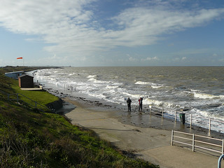
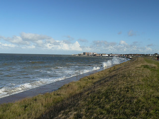
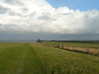
This is an easy coastal walk - it is entirely flat - along the north Kent coast. It passes the dramatic landmark of Recluver, the remains of the twin towers of a 12th C church set amongst the ruins of a Roman Fort (free entry, English Hertitage, Wikipedia). In summer there are opportunities for sea swimming throughout (see notes below), and though the walk is almost entirely on tarmac or concrete paths, with only a 1km section beyond Reculver that is on grassy clifftops, there are still plenty of rural delights. After an initial section on the seafront promenade (or cliff top park) of Birchington-on-Sea, a quiet seaside town, you follow the raised sea wall over remote flat marshland (a sea channel until the 12th century: see Points of Interest below), along an unspoilt shingle beach which has interesting wildflowers (in summer) and seabirds: also fine views of distant shipping and windfarms, and the ruins of Reculver church as an aiming point on the horizon. Beyond Reculver your path takes you along the top (or bottom) of a very pleasant grassy slope facing the sea, which again has interesting wildflowers in summer, to the charming, if slightly faded, seaside resort of Herne Bay, complete with pier, beach huts, cafes and bars. Incidentally, while one may think of this as a perfect summer walk, it makes a nice winter outing too, if the weather is fine. The low sunlight on the sea and marshes can be quite entrancing, and at this time of year the birdlife is more numerous, particularly at low tide when they feed on the shallow shingle and mudflats. Best of all this is a walk almost entirely without mud. Note that there is no shelter, however, so in rain it can be fairly wretched. If the winds are blowing strongly from the west, consider reversing the walk (see below.) |
| In Reverse |
It is quite possible and easy to do this walk in reverse - indeed, if the wind is blowing strongly from the west, this is a good idea as there is otherwise no shelter on this walk. The only disadvantage to doing the walk in this direction is that the flatlands of the marshes between Reculver and Birchington might be a bit of an anticlimax after the scenically more dramatic section around Herne Bay. (You also do not have the towers of Reculver church as your aiming point as you walk across them). Birchington is a fairly quiet place to finish and does not have the charm of Herne Bay: but it does have some tea options: see below. Walk directions for this option are below. |
| Extensions |
This walk can be extended to the east or west to link up with our other coast walks (Margate to Ramsgate, and Faversham to Whitstable) if you want to walk the entire coastline. Just choose one, doing both at about 16 miles on pavement is a bit too long. We did look at splitting this walk into 2 shorter 8 miles walks, but the stations just weren't in the right place... West Extension : Herne Bay to/from Swalecliff and WhitstableYou can continue along the coast past Herne Bay for 4km to Hampton (pub) and Swalecliff (Long Rock headland / nature reserve), then head inland for its station, Its a further 3 km (i.e. 7km / 4 miles total) to Whitstable, a large seaside town with some historic buildings. The beaches are shingle, there is a good flat promenade, with occasional lines of beach huts and beach cafes, backed by quiet residential neighbourhoods until the outskirsts of Whitstable. Both stations are closer to London on the same line, so your return ticket is valid. East Extension : Birchington to/from Westgate and MargateIn the reverse direction, you can carry on past Birchington for 2km (1.2 miles) to Westgate-on-Sea which has a popular and busy seafront cafe in season and a station just inland of its main bay. Another 2.5km (1.6 miles) (so 3.8 miles total) brings you to Margate, whose station is clearly visible from the seafront just at the start of its main beach. All of this walk is on seafront promenades or quiet residential clifftops, with short headlands seperating small towns with quiet beaches. If extending the walk in this way you will need to buy a day return to whichever town you end up in. |
| Cycling |
The initial section of promenade, from Birchington to Reculuver, is wide, flat, and car free - it's suitable for cycling with young children or nervous beginners. |
| Transport |
Trains go once an hour each from London Victoria or St Pancras, to Birchington on Sea with a journey time one hour 38 minutes from Victoria and one hour 26 minutes from St Pancras. Slightly cheaper fares can be obtained on the Victoria trains, and you can also use tickets from London travelcard zone boundaries on these trains, which you cannot on the St Pancras ones. Herne Bay is one stop before Birchington on Sea, so buy a day return to Birchington on Sea. Trains are 2/hour Mon-Sat, and 1/hour on Sunday. Margate, about 1hr 30mins, has a better service. Suggested Train: Take the train nearest to 9.30am. By Car: This is a long quiet seafront. Everywhere outside the town centres has free parking. |
| Eat |
Food and drink options are listed below from east to west. If on the main walk (Birchington to Herne Bay), the most convenient lunch stop is Reculver, with tea in Herne Bay, though if you start late, Minnis Bay has possible lunch options and tea could be had at the cafe in the Reculver Visitor Centre. On the reverse walk (Herne Bay to Birchington), Reculver is again the best lunch option, with other possibilities at the start of the walk in Herne Bay. Minnis Bay provides the best tea options, though there is a later pub option by Birchington station. On the east extension Westgate-on-Sea and Margate have late refreshment options, while on the west extension that is true of Hampton, Tankerton and Whitstable. If starting from Whitstable or Swalecliffe and walking east, Herne Bay is a possible early lunch stop and Reculver an early tea stop. Margate
Westgate-on-Sea
Birchington
Minnis Bay
Reculver
Herne Bay
Hampton
Tankerton
Whitstable
|
| Swimming |
Almost the whole coast you follow on this walk is suitable for swimming, though it is worth noting that when the tide is running there can be a fairly strong current lateral to the shore. Usually this just means that you make little progress relative to the shore when swimming in one direction or the other, but don't go too far out unless you are confident in such conditions. If in doubt, only swim where you see other people doing so. The other issue is the state of the tide. At low tide the sea retreats some way across a flat sandy (at Birchington and Herne Bay) or shingle bottom. At such times you have to wade out a long way to get enough depth of water for swimming - and if you wade too far there may be sticky mud underfoot. When the tide is at the mid level, however, this means that there is a large expanse of not too deep water to swim in. Given this, where you swim will probably be determined by at what point on the walk the tide is highest, but from a scenic point of view the nicest swimming spot is probably the long beach running into Herne Bay, which is backed by green slopes. Incidentally the sea hereabouts is a bit brown, but this is due to sediment from the muddy bottom, not pollution: North Kent beaches generally all meet bathing water standards these days, one possible exception being after heavy rain, when there can be some sewage overflow. |
| Points of interest |
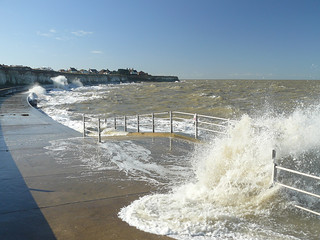
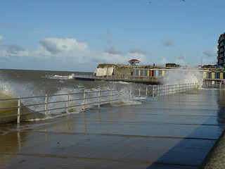
In winter at the Birchington end of this walk you can see a good variety of seabirds, including oyster catchers and large flocks of dark-coloured brent geese. The latter migrate to here from their summer nesting grounds on the Siberian tundra to spend the winter feeding on the mudflats at low tide, roosting at high tide in the marshy fields of the former Wantsum Channel (see next paragraph). The Isle of Thanet was once a real island and was separated from the rest of Kent by the Wantsum Channel, which stetched from Reculver to Richborough, just outside Sandwich. The Romans had a fort at either end of this sea channel, and it is on the ruins of the Reculver one that a Saxon monastery was built, whose ruined church is such a feature on this walk. The Wantsum Channel started to silt up in the 12th century and was soon reclaimed for farmland, but even today you can see the broad swathe of flat land where it used to be. The sea wall between Minnis Bay and Reculver was built in 1954-5 as a response to the disastrous floods of 31 January 1953, when a combination of high tide, wind and low pressure created floods of up to 5.6 metres above sea level from Lincolnshire to the Thames Estuary. Not surprisingly the waters penetrated a significant way inland at this point. Offshore windfarms divide opinion, but for many they provide a point of interest on this walk. The one that is most obvious is the Kentish Flats array just north of Herne Bay: this was the UK's very first offshore windfarm and has by modern standards a very modest 30 turbines, with plans for 15 more. Further out to sea, on the far horizon to the north east (so over your right shoulder if walking from Birchington or ahead left if you are coming from Herne Bay) you can also see on clear days the massive 100 turbine London Array. Finally due eastwards towards Margate you can glimpse the Thanet Offshore windfarm which is off the coast of Ramsgate. On either side of the Kentish Flats windfarm you may be able to see a cluster of dark box-like structures on stilts. These are the Maunsell Forts, anti-aircraft gun platforms erected in the Second World War. The ones to the left (west) as you are looking out to sea at the windfarm are the Red Sands Forts and the ones to the right (east) are the Shivering Sands Forts. In the early 1960s these were for a time used by pirate radio stations under the (mistaken) assumption that they were outside UK territorial waters. If you are wondering what the odd wooden pavillion-like structure way out in the sea to the north of Herne Bay is, it is the original end of the town's pier, most of which was destroyed in a storm in 1978, though a shoreward stump that you can walk on still remains. The pier is actually the third on this site, the original opening 1832, with a very serious purpose. In those pre-railway days sea was often the quickest way to get around, and for thirty years paddlesteamers from London used to call at this pier carrying passengers not just for Kent but also for the continent (travellers carried on by road to Canterbury and Dover and then took boats across the English Channel). This original pier apparently had a wind-driven railway to carry passengers' luggage to and from boats (if there was no wind, the carts carrying the luggage had to be pushed by hand). The pier needed to be so long in order to provide sufficient depth for ships to anchor at all states of the tide (see the pier which still exists in Southend, which is 1.3 miles long for the same reason). After the coming of the railway in 1861 the pier was more of a embarkation point for pleasure trips. In the Second World War it was partly dismantled for fear it might be used by invasion forces. Restoration after the war was apparently not very well done, and the result was the loss of the pier in the 1978 storm. Only its far end still remains as a reminder of just how astonishingly long it once was. |
| Profile | |
|---|---|
| Help Us! |
After the walk, please leave a comment, it really helps. Thanks! You can also upload photos to the SWC Group on Flickr (upload your photos) and videos to Youtube. This walk's tags are: |
| By Train |
Out (not a train station) Back (not a train station) |
| By Car |
Start CT7 9RD Map Directions Return to the start: Finish CT6 8PJ Map Directions Travel to the start: |
| Amazon | |
| Help |
National Rail: 03457 48 49 50 • Traveline (bus times): 0871 200 22 33 (12p/min) • TFL (London) : 0343 222 1234 |
| Version |
Apr-24 DAC |
| Copyright | © Saturday Walkers Club. All Rights Reserved. No commercial use. No copying. No derivatives. Free with attribution for one time non-commercial use only. www.walkingclub.org.uk/site/license.shtml |


Walk Directions
From East to West
Brief directions for the main walk. It is mostly pretty straightforward - just following the coast - but in a few places you might get confused: hence the points below.
Birchington-on-Sea to Herne Bay
- Coming off the London train, do not cross the footbridge, but instead go up the tarmac ramp off the platform for 50 metres to cross over Lyell Road. Here turn left for 10 metres to then turn right down Beach Avenue (which subsequently becomes Beresford Gap) in the direction of the sea.
- On reaching the coast, you have the choice of walking along the low cliff edge or (depending on conditions) along the promenade at the base of the cliff. Either way, you pass around a headland, a shallow bay, then another headland to emerge onto Birchington's main beach, Minnis Bay.
- Walk to the far end of Minnis Bay, either on the promenade or on the higher path along the top of the bank behind it.
- At the far end of the beach continue along the sea wall across the marshes of the former Wantsum Channel (sea till the 12th century): the ruins of Reculver Church are in clear view ahead on this 4.5km (2.7 mile) section.
- When you get to Reculver, you find the King Ethelbert Inn just beyond the church ruins, and the HatHats Coffee Company cafe in the Reculver Visitor Centre 150 metres further on at the far end of the car park.
- After lunch, continue on up the wide grassy slope beyond. There are two paths here, one on the seaward edge and the other slightly further inland. Use either: they both have fine backward views of Reculver and eventually come to the same place.
- After 1.5km, at the very top of the hill, pass through bushes (on the cliff top path) or to the left of them (on the more inland path) to emerge in 50 metres into a grassy space with a car park at its far left-hand end. Cross this diagonally, heading for its far right-hand corner.
- In the far right hand corner of the grassy space, pass through a kissing gate and carry on along a tarmac path across the slope.
- In 200 metres the path turns more directly downhill on concrete steps. You can carry on down the steps to the seafront promenade and walk into Herne Bay that way, but the recommended route is to turn left after 10 metres onto an earth path between bushes.
- In 300 metres this path is blocked by a black metal fence and turns left uphill. In 40 metres turn right at a T-junction onto a tarmac path that soon comes out along the top of a green space.
- In 150 metres turn right downhill on a path that crosses a footbridge in another 30 metres. Beyond, follow the path round to the right alongside a wooded ditch.
- In 100 metres follow the path round to the left uphill. Ignore a fork left in 10 metres to keep along the fence.
- In 40 metres emerge into a car park and curve left beyond it onto a broad tarmac path. In 30 metres more carry on up a road past houses.
- After 300 metres on the road there is a car park on the right. Turn right across this, directly towards the sea. In 60 metres, just before steps down to the seafront, turn left onto a concrete path along the top of the escarpment.
- In 600-700 metres this merges with a much wider path, which brings you in 1km to the centre of Herne Bay. Keep along the seafront. Of the two branches of Makcari's, the best is the one in the former bandstand, 100 metres beyond the clock tower. The Pier is 150 metres beyond the bandstand.
- To reach Herne Bay station: With the entrance to the Pier behind you, cross the coast road and then head south along Station Road (to the left of a large block of flats), to reach the station after 800 metres.
- To continue to Swalecliffe or Whitstable, stay on the seafront beyond the pier. See the GPX or map for details of when to turn inland for the station.
From West to East
This is the walk in reverse. Each section ends at a train station
A) Whitstable to Swalecliffe
- Old town and High Street route: From the station, left on Railway Avenue (100m), which becomes Cromwell Road (300m). Right on Oxford Steet which becomes the High Street. Join the seafront path, turn right, and walk!
- Short route: From the station, turn right on Railway Avenue, then first left on Westmeads Road. Cross the car park, cross the road, and veer left a bit down a service road to the left of the indoor Bowls Centre. At the sea, turn right, and walk!
- Pass the recommended Hotel Continental (bar / cafe on the ground floor), and The Bubble Cafe on the promenade.
- Continue along Tankerton beach, passing The Royal (pub), the Sea View cafe, and JoJo's restaurant.
- Just before the low headland jutting out into the sea, and before the skate park, turn inland on Brook Road, then turn left on Herne Bay Road for Chestfield and Swalecliff station
B) Swalecliffe to Herne Bay
- Cross the headland (Long Rock nature reserve), the only 'nature' section of this coastline. This is the quietest part of this coastline.
- Follow the promenade in front of a caravan park, then in front of Studd Hill, towards a headland with Hampton's short pier.
- Pass the Hampton Inn pub on the point. The pier has a free car park.
- Continue along the promenade, passing beach huts towards Herne Bay's pier
- For Herne Bay Station, take the first road inland (Station Road) after the pier (800m).
C) Herne Bay to Birchington-on-Sea
- Coming out of Herne Bay station, turn right to exit the car park at its right-hand end. Carry on down the road beyond, passing the Heron pub on your right. Follow this road for 800 metres to emerge on the seafront by the pier. At the pier, turn right on the seafront. (Alternatively after 200 metres on Station Road veer right into Memorial Park, cross it diagonally, and then turn left at its far end to walk down through the town to the sea. But doing this misses out the most interesting bit of Herne Bay's seafront.)
- In 150 metres pass through the bandstand (which used to project out over the sea and have seaward terraces for sunbathing: it now has Makcari's cafe in its centre) and in 100 metres more pass the clock tower and keep on along the seafront promenade.
- Just before the clock tower, is The Saxon Shore, a Wetherspoons. Continue along the promenade until the end of town.
- You can stay on this promenade along the beach for 2.5km if you wish. Eventually you are forced up onto the cliff top by steps: see point 10 below.
- A more scenic option (recommended) is to go up onto the "cliff" top (in fact there is no cliff, just a grassy slope). To do this higher route, follow the road behind the promenade when it curves right uphill, with a green slope to its left, about 350 metres after the clock tower. 50 metres up the slope turn left along a car-wide tarmac path across the hillside, with the sea parallel and downhill to your left.
- After about a kilometre the car-wide path starts to go sharply downhill beyond a vehicle-blocking barrier, but you can stay on the cliff top by forking right onto a narrower tarmac path that runs in front of houses.
- After 600-700 metres this path ends at a small grassy area with picnic tables, and bushes blocking your way on its far side. Veer right here to the road and turn left along it (still parallel to the coast but now with houses between you and the view).
- In 250 metres, where the road ends, turn right just before a car park up an earth and stone track.
- In 60 metres turn left up a tarmac path that curves right to pass into bushes in 30 metres. In another 30 metres a former path across a footbridge is blocked by a black metal fence, so you have to follow the path to the right, initially along the fence and then with a ditch to your left.
- In 100 metres the path turns left to cross the ditch on a footbridge. In 30 metres more, with a fieldgate and road ahead, turn left onto a path along the top of the green space.
- In 150 metres turn left downhill on a side path. In 40 metres the path meets the black metal fence and curves right along it, contouring across the slope.
- After 300 metres among bushes this brings you out onto the open clifftop, at a T-junction: turn right here, uphill, initially up steps, then on a tarmac path across the slope. (The seafront route joins along this path.)
- In 200 metres, at the very top of the hill, pass though a kissing gate and walk diagonally across a field towards the left-hand edge of the car park on its far side.
- When you get to the car park, turn left along a path leading from its far left-hand corner. This passes bushes for 60 metres and then emerges onto open grassy cliff top. The ruins of the Saxon Reculver Church are visible about 1.5km ahead, and the way to it not in doubt.
- Entering Reculver you pass first the Visitor Centre, which contains the HatHats Coffee Company cafe, with the King Ethelbert Inn, the lunchtime pub, 150 metres beyond.
- After lunch go past the ruined church of Reculver and follow the sea wall beyond as it crosses the flat marshes, the former bed of the Wantsum Channel.
- After 4.5km (2.7 miles) you come to the main beach of Birchington-on-Sea, with the houses and flat blocks of the town ahead. You can either follow the concrete promenade around its bay, or stick to the path on the top of the embankment.
- At the far end of the bay you pass the Windshack Cafe on the beach, and The Minnis Bay Bar & Brasserie on the upper level (it is invisible from the promenade). The Waves Cafe is next to the Minnis Bay Bar and Honey'z Cafe and Beach Bar just behind it. Taken together, these are your best options for tea if ending the walk in Birchington (but see also paragraph 20 below).
- Continue on around the headland beyond the bay (again you can follow the promenade or keep to park paths along the top of the chalk cliffs, which give nice views).
- Beyond the headland go round another substantial bay, Grensham Bay, and around another headland. If on the promenade, ignore a tarmac path leading inland from this second headland through a cleft in the cliffs.
- In another 200 metres, at the head of the bay, you come to a tarmac ramp as wide as a road which leads directly uphill from the head of the bay, signposted to Birchington station. (If you are on the cliff top path, the path curves right inland to join the top of this ramp when it reaches a car road). You can see the cliff edge ahead is blocked by housing
- At the top of the ramp, walk directly inland along Beach Avenue for 400 metres, until it comes to a T-junction. The rather well-concealed entrance to Birchington station is just to the left on the far side of the road. For refreshments, follow the road to the left and over the railway bridge to reach Christie's pub, in 60 metres on the right. For more options, turn left on the main road just past the pub and follow it round to the right where it forks in front of a triangular grassy space. This brings you to Birchington's high street, which has a couple of fish and chip shops and a Sainsbury's Local supermarket with a Costa Coffee machine.
D) Birchington-on-Sea to Westgate-On-Sea
- Follow the beach level promenade (only) for 1km on a wide curvy concrete promenade at the bottom of low (but steep) chalk cliffs (there is no beach here). There is an access point after 500m. NB: The cliff edge above has private housing, one of the few places on this coastline, so there is no cliff top alternative, only inland roads.
- Join the cliff top path at Epple Bay where the promenade ends (there is no choice - the promenade ends), and follow the coast road for 500m (the only section of road walking on this coast). You can see more promenade below the road, but it doesn't link up - there is a small gap.
- Leave the road, and rejoin the beach at Westgate-on-Sea Bay. From here on, you can choose between wide sea level concrete promenade and cliff top path, all they way to Margate
- At the far end of Westgate's beach is the popular West Bay Cafe right on the promenade
- After the headland, turn inland on St Margaret's Road for Westgate-On-Sea station
E) Westgate-on-Sea to Margate
- Continue on the past quiet St Mildred's Bay (beach huts, but no cafe)
- Then, its quiet Westbrook Bay (large beach level car park) - either the wide beach level promenade, or the cliff top path above, which is seperated from a quiet housing by a wide grass lawn.
- Finally, you come to a headland with large appartment blocks. Follow the beach level path around it and you come to busy Margate's main beach.
- Where the promenade meets the road, cross the roundabout for Margate station.
- Or, continue for the Mechanical Elephant (Wethies pub), the town centre, The Turner Gallery (free entry), and the harbour arm (nice small pubs)