Black Mountain (Fan Brycheiniog and Fan Foel) from Glyntawe walk
A strenuous start then easy route finding along a glacial ridge through wild upland scenery to one of the highest peaks in the Brecon Beacons National Park with spectacular views.

Picws Du, from Fan Foel
SWC Walk 86 Fan Brycheiniog and Fan Foel (The Black Mountain)
Oct-16 • thomasgrabow on Flickr
swcwalks swcwalk86 banner 30382448484
Fan Fechan Moraine at bottom of Fan Hir Escarpment
SWC Walk 86 Fan Brycheiniog and Fan Foel (The Black Mountain)
Oct-16 • thomasgrabow on Flickr
swcwalks swcwalk86 walkicon 31167951336

Northerly Views from Fan Hir towards Glasfynydd Forest
SWC Walk 86 Fan Brycheiniog and Fan Foel (The Black Mountain)
Oct-16 • thomasgrabow on Flickr
swcwalks swcwalk86 walkicon 30396644303
![Wild Hill Ponies (on Cefn Disgwylfa) [off-route] SWC Walk 86 Fan Brycheiniog and Fan Foel (The Black Mountain)](https://live.staticflickr.com/5502/31089732411_b74eec214e_n.jpg)
Wild Hill Ponies (on Cefn Disgwylfa) [off-route]
SWC Walk 86 Fan Brycheiniog and Fan Foel (The Black Mountain)
Oct-16 • thomasgrabow on Flickr
swcwalks swcwalk86 walkicon 31089732411

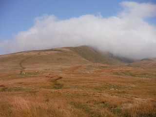
Fan Gyhirych in the Evening Sun
SWC Walk 86 Fan Brycheiniog and Fan Foel (The Black Mountain)
Oct-16 • thomasgrabow on Flickr
swcwalks swcwalk86 walkicon 31168023416

Fan Gyhirych, from ascent up Allt Fach
SWC Walk 86 Fan Brycheiniog and Fan Foel (The Black Mountain)
Oct-16 • thomasgrabow on Flickr
swcwalks swcwalk86 30382505994
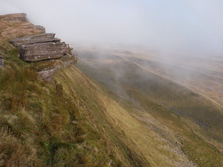
Fan Hir Ridge in clouds
SWC Walk 86 Fan Brycheiniog and Fan Foel (The Black Mountain)
Oct-16 • thomasgrabow on Flickr
swcwalks swcwalk86 31089858121
| Note |
In good conditions this walk is suitable for all levels of experience. There is a more challenging version for experienced walkers : Hiker's Version |
|---|---|
| Length | 14.6 km (9.1 mi) with about 740m ascent |
| Toughness | 6 out of 10 |
| Walk Notes |
A stunning ridge walk, out and back, to the highest peak on The Black Mountain (Fan Brycheiniog, 802m), one of the highest peaks in South Wales, with an option to continue to the next top along the ridge, Fan Foel (781m) for more stunning views to the North. Often referred to as the last wilderness in the Brecon Beacons National Park, the landscape is glacial, treeless, with steep escarpments, and with stunning views over South and West Wales and to the Bristol Channel. From a bus stop on the A4067 you climb steeply up to the Fan Hir ridge, and follow on with a long gradual ascent to the summit of Fan Brycheiniog ('Brecknock Beacon') with its storm shelter and trigpoint. The route is very exposed, so this is a walk for a clear sunny day, with little wind or rain. After dropping down to a saddle you re-ascend to the most northerly top on the ridge Fan Foel, the site of an early Bronze Age Round Barrow. From here you have spectacular views to the moorland and open country to the north, as well as along the stunningly picturesque Bannau Sir Gaer ('Carmarthen Fans') to the west. Return the way you came. Although the path isn't marked, even on the OS 1:25,000 map, it is quite clear, and the last half along the ridge is obvious. The drops are steep only on one side, but very gentle on the other, so none of it is scary, or needs a head for heights. Note: The Black Mountain (Y Mynydd Du) is the western most peak of the Brecon Beacons. The Black Mountains (plural) are a range of hills to the east of the Brecon Beacons, on the England-Wales border. |
| Walk Options |
Cut out the most northerly top Fan Foel and return from Fan Brycheiniog, leaving you with a 13.1 km (8.1 mi) walk. For a longer walk, continuing along the Bannau Sir Gaer ridge and returning along the bottom of the esarpment, see SWC Walk 279 The Black Mountain - Y Mynydd Du (Glyntawe Circular) |
| Maps | OS Explorer: OL12 (Breacon Beacons National Park)
OS Landranger: 160 (Breacon Beacons) Harvey Superwalker XT25: Breacon Beacons West/Bannau Brycheiniog Gorllewin Harvey British Mountain Map: Breacon Beacons/Bannau Brycheiniog |
| Travel |
Glyntawe, Field Study Centre Bus Stop, map reference SN 846 167, is 248 km west of Charing Cross, 208m above sea level and in the Tawe (or Swansea) Valley (Cwm Tawe in Welsh) in Powys, Wales. It is on line T6 (Swansea - Neath - Ystradgynlais – Brecon), with 11 buses a day Mon-Sat and 5 on Sundays and Bank Holidays, with a journey time of 43 mins from Neath (and 32 mins from Brecon). Satnav: SA9 1GS. Drivers should not park on the two pub car parks in the village, as these are for customers only, but should try to find roadside spaces along the few lanes in the village. |
| Stay | Accommodation is available nearby in Craig-Y-Nos, Pen-Y-Cae or Abercraf, and further along the bus line in Ystradgynlais, Sennybridge or Brecon. |
| Lunch and Tea |
Tafarn y Garreg A 4067, Glyntawe, Swansea, Powys, SA9 1GS (01639 731 415).
|
| Brecon Beacons |
The Brecon Beacons National Park is in south Wales. It consists of bare, grassy, glacial mountains, with north facing escarpments. Its peaks, just shy of 1,000m (3,000ft), are the highest mountains in the southern UK. The national park is also noted for reservoirs, and the Dan yr Ogof caves. Its 4 mountain areas, from west to east are:
|
|---|---|
| Mountain Safety |
This is a challenging but achievable walk in good weather, even for young children, but it is in remote exposed mountain areas. It is possible to twist an ankle on any walk, and it will take hours for mountain rescue to drive to the trailhead, then climb the mountain, to reach you. So:
|
| Welsh Glossary |
aber: estuary, confluence, river mouth; afon: river; affwys: abyss; allt: hillside, cliff; aran: high place; ban/fan/bannau (pl): peak/beacon/crest, hill/mountain; big: peak; blaen: source of river, head of valley; bod: dwelling; bre: hill; bron: hill-breast; bryn: hill; bwlch: gap/col/pass; cadair: chair; cae: field; caer/gaer: stronghold, fort; capel: chapel; carn/garn/carnedd/garnedd: cairn, heap of stones, tumulus; carreg/garreg: stone, rock; castell: castle; cefn: ridge, hillside; celli: grove/copse; cerwyn: pot-hole; cist: chest; clog/clogwyn: cliff; clun: meadow; clwyd: hurdle/gate; clydach: torrent; coch/goch: red; coed: wood; craig/graig: rock; crib/cribyn: crest, ridge, summit; crug: mound; cul: narrow; cwm: hanging valley/corrie/bowl/dale; cyfrwy: ridge between two summits (saddle); ddinas: fort; dibyn: steep slope, precipice; dim: no; din: hill-fortress; disgwylfa: place of observation, look-out point; dôl: meadow; du/ddu: black, dark; dwfr/dŵr: water; dyffryn: valley; -dyn: fortified enclosure; eglwys: church; eira: snow; eisteddfod: meeting-place, assembly; esgair: ridge; fach/bach: small; fawr/mawr: large; fechan: smaller; ffald: sheep-fold, pound, pen, run; ffordd: way, road; ffridd: pasture; ffrwd: stream, torrent; ffynnon: spring/well; gallt: wooded hill; ganol: middle; garth: promontory, hill, enclosure; glan/lan: river-bank, hillock; glas: green (when referring to grass, pasture or leaves), blue (when relating to the sea or air); glyn: deep valley, glen; gors: bog; gorsedd: tumulus, barrow, hillock; gwyddfa: mound, tumulus; gwylfa: look-out point; gwyn/gwen: white; gwynt: wind; hafn: gorge, ravine; hafod: summer dwelling; hen: old; hendre(f): winter dwelling, old home, permanent abode; heol: road; hesgyn: bog; hir: long; is: below, lower; isaf: lower/lowest; llan: church, monastery; llawr: level area, floor of valley; llech: slab, stone, rock; llther: slope; lluest: shieling, cottage, hut; llwch: lake, dust; llwybr: path; llwyd: grey, brown; llwyn: bush, grove; llyn: lake; llynwyn: pool/puddle, moat; maen: stone; maes: open field, plain; mawn: peat; mawnog: peat-bog; melyn: yellow; merthyr: burial place, church; moel/foel: bare, bald/bare hill; mynydd: mountain, moorland; nant: brook/stream, dingle/glen; neuadd: hall; newydd: new; ogof/gogof: cave; pant: hollow; parc: park, field, enclosure; pen: head, top/end, edge; penrhyn: promontory; pentre(f): homestead, village; perfedd: middle; perth: bush, brake, hedge; plas: hall, mansion; pont/bont: bridge; porth: gate/gateway, harbour/bay/landing-place/ferry; pwll: pit, pool; rhiw: hill, slope; rhos: moor, promontory; rhudd: red, crimson; rhyd: ford; sarn: causeway; sgwd/rhaeadr: waterfall; sticill: stile; sych: dry; tafarn: tavern; tâl: end, top; talar: headland (of field); tan/dan: below; tarren/darren: escarpment; tir: land, territory; tor: break, gap; tre/tref: settlement, hamlet, town; twlch: tump, knoll; twll: hole, pit; tŵr: tower; twyn: hill; tŷ: house; uchaf: upper, highest; uwch: above, over; waun/gwaun: moorland, meadow; wen/wyn: white; y, yr, ‘r: the; ynys: island, holm, river-meadow; ysgol: ladder, formation on mountain-side/school; ysgwydd: shoulder (of mountain); ystafell: chamber, hiding-place; ystrad: wide valley, holm, river-meadow. |
| Profile | |
| Help Us! |
After the walk, please leave a comment, it really helps. Thanks! You can also upload photos to the SWC Group on Flickr (upload your photos) and videos to Youtube. This walk's tags are: |
| By Car |
Start Glyntawe, Penycae, Swansea, West Glamorgan, SA9 1GS Map Directions |
| Amazon | |
| Help |
National Rail: 03457 48 49 50 • Traveline (bus times): 0871 200 22 33 (12p/min) • TFL (London) : 0343 222 1234 |
| Version | |
| Copyright | © Saturday Walkers Club. All Rights Reserved. No commercial use. No copying. No derivatives. Free with attribution for one time non-commercial use only. www.walkingclub.org.uk/site/license.shtml |


Walk Directions
- [Map 1] Start from the bus stop by the Tawe bridge.
- Walk through a metal field gate just south of the bridge along an unsigned car wide footpath, with the river on your right. You walk through a couple of metal field gates and in 650m reach Ty Henry farm (on the OS map).
- Veer right through the right of two metal field gates with a Beacons Way marker 10m ahead on a tree down into a grassy field and in 40m turn right towards the river on your right, on a dog leg. You walk to the right of an electricity pole with markers on it and in another 55m go through a fence gap (a missing gate) to emerge on a wide grassy riverside path with a wooden two-railed bridge on the right.
- Turn left along the riverside path with a wire fence on your left and in 180m turn left through a metal gate with a Beacons Way marker, now along a car wide track between fences, then drystone walls. In 100m walk through a rusty metal field gate and turn right and in 30m left around some sheep pens. In 10m go through a metal gate into a steep open moorland hillside by a Brecon Beacons National Park Access Land sign.
- Continue along the sheep pen wall and then in the same direction steeply uphill, initially along a rough path through bracken (280°), with views opening up over the valleys to the right and back over Glyntawe.
- In 210m the route turns right (335°), as you leave the bracken behind, and in 230m it turns to a wider grassy path, in 100m it turns left and in 25m right again, as the path narrows again for a stretch (this stretch is a streambed after rain).
- In 400m continue in the same direction (ignore a right fork) and in another 100m the path temporarily levels out at about 450m above sea level (Allt Fach on the OS map) where it curves right, with first views ahead (on a bearing of 330°) of the escarpment to conquer.
- The path is generally – but not always – well-defined, sometimes only by quad bike or sheep tracks, and passes a few boggy stretches, where close attention is required.
- In 750m it joins a wider track on the left. In another 1.4 km you have the steep drop of the stunning sandstone escarpment on your right (a very good picnic spot) and get views on the right in the distance of the distinct tops of Pen y Fan and Corn Du on a bearing of 100° about 25 kilometres away (SWC Walk 85 and 278) and The Black Mountains to the left of these.
- Down on the right at the foot of the escarpment you see the return route along a small whale-back shaped ridge. This ridge (Fan Fechan) is a rare phenomenon: a moraine, caused by a glacier leaving behind debris of soil and rock along the edge of its ice block. Further to the right you can see the Upper Cwm Tawe (the Tawe Valley).
- [Map 2] In 1.9 km you cross the first summit of the walk: Fan Hir (‘Long Beacon’, at 760m above sea) and descend from there to the low saddle of Bwlch Giedd (706m above sea) where – in 500m – an engineered path joins from down right from along the shores of Llyn Y Fan Fawr (‘Lake of the big Peak’), a glacial lake.
- Continue in the same direction along the ridge up the steep path and in 600m reach the highest top of the day, Fan Brycheiniog (‘Brecknock Beacon’) at 802m above sea, with its storm shelter and trig point. From here, on a clear day, you can get views as far as Exmoor across the Bristol Channel, Cardigan Bay, Snowdonia and the coasts of the Gower Peninsula and Pembrokeshire.
- Follow the escarpment curving right to another cairned subsidiary top (Twr Fan Foel, at about the same height as Fan Brycheiniog), where there are some dramatic drops on both sides. Turn left and follow the ridge to the next top, Fan Foel, the escarpment’s northern top, whose large plateaued top you reach in 500m (the rock-lined top is in fact what’s left of an early Bronze Age (ca. 2000BC) round barrow).
- This top is more flat than the previous ones, but still offers far views in a northerly direction. [The boundary between Powys and Carmarthenshire runs through it]
- To the west you have the stunning ridge of Bannau Sir Gaer (‘Carmarthen Fans’).
- Retrace your steps back the way you came.