Bow Brickhill to Woburn Sands walk
Woburn village, Woburn Abbey (stately home) and deer park via woodland and many gentle hills


Woburn and Woburn Abbey Deer Park
| Length |
18.7km (11.6 miles), 5 hours 30 minutes. For the whole outing, including trains, sights and meals, allow at least 10 hours. |
|---|---|
| Toughness |
6 out of 10. |
| OS Maps |
Explorer 192 or Landrangers 165, 153 & (for the last 750m) 152. Bow Brickhill, map reference SP 896 348, is in Buckinghamshire, 2km east of Bletchley. Woburn is in Bedfordshire. |
| Features |
Woburn is the main delight of this walk – the ancient town itself, Woburn Abbey (a stately home) and its landscaped deer park. The route reaches Woburn mainly through woods and via a golf course, with some impressive redwood trees along the way. After the Safari Park the route is through the pleasant village of Aspley Guise then on to Woburn Sands. Short bits of the woods can be very muddy in wet weather and there are (relatively easy) uphills and downhills all day, but mainly in the morning. The majestic deer in Woburn Park are impressive, even by London's Royal Park standards, but be careful not to allow dogs to disturb them, particularly when they are rutting (October) or giving birth – the deer may leave their newborn calves or give birth prematurely. OS Mapping (and so the GPS files) is relatively inaccurate (up to 20 metres out) in Back Wood at the start of the walk. There are many paths through the woods, so care is needed. [June 2024] The public footpath through the safari park has been re-routed and you can no longer see elephants or giraffes from the path. Just plenty of deer! |
| Walk Options |
In winter #cw141 has a less muddy route through the woods at the start. There are still over 10 km to be walked after lunch in Woburn so you may wish to take a bus to Leighton Buzzard or Bletchley. This would miss out the best bits of the walk. You can take an out-and-back detour shortly after entering Woburn Park to visit Woburn Abbey or view the Abbey and its outbuildings from the outside. A longer loop using this path is suggested. You can head for the railway station in Aspley Guise instead of continuing the walk to Woburn Sands but this only saves about 1km. #swc394 is a reimagined version of this walk, with a shorter start (i.e. less woods), a similar route through the deer/safari park, and a longer ending. |
| History |
Woburn Abbey (tel 01525 290 333), set in a vast park about 16km in circumference, is the seat of the Duke of Bedford, although it was founded for Cistercian monks in 1145 by Hugh de Bolsbec, a Norman whose father came over with William the Conqueror. Both Elizabeth I and Charles I were entertained here. The Abbey was partially reconstructed and extended starting in 1744 in Totternhoe stone. The House and formal gardens are currently undergoing major refurbishment and will not reopen to the public until 2025. For reference, admission to the house and gardens used to be £ 18.00. The landscaped Deer Park is a deer breeding centre. It remains fully open with no charge provided visitors stay on the well marked footpaths (i.e. the deer park is not open access - there is no option to buy admission - you may only use the public footpaths). Woburn Safari Park (inside the deer park) is car-only drive-through safari. About £30 per person. There is no pedestrian option. Woburn the town, was almost completely gutted by fire in 1729. St Mary Old Church, Woburn, whose tower dates from the twelfth century, is now a Heritage Centre (tel. 01525 290631) covering local history. From Easter to September the Centre is open Monday to Friday 2.00 pm to 4.30pm, Saturday, Sunday and Bank Holidays, 10.00 am to 5.00 pm (plus weekends only in October). Besides many pubs and cafes, it has a Woburn Lido, a summer-only open air community swimming pool, but you may have to book ahead St Mary, the imposing parish church, graced with devilish gargoyles, was built by the eighth Duke of Bedford in 1868 and has a memorial to Mary, Duchess of Bedford. The village of Aspley Guise was originally called Aepslea, meaning a clearing in the aspen, with large herds of swine kept in the surrounding woods. The Parish Church of St Botolph, Aspley Guise, has Norman and medieval traces and a brass from about 1410 of a kneeling priest. |
| Travel |
Note that there is currently no train service on the Bletchley-Bedford branch line on Sundays and Bank Holidays. Take the train from Euston Station to Bow Brickhill, changing at Bletchley. Journey time about 1 hour. Buy a day return to Woburn Sands (or Aspley Guise which is 1 stop further). Suggested train: nearest to 9.50am. Trains back from Woburn Sands (or Aspley Guise) to Euston are about once an hour, again via Bletchley. If you buy a more expensive "any route permitted" ticket, you could also take the train in the other direction and return via Bedford to St Pancras. The train out of Euston often runs late, so leave plenty of time for the connection at Bletchley, by taking a train earlier than the journey planner suggests. If you still miss the connection, take a taxi to Bow Brickhill. By car, all 3 stations have free on street parking and are on same line (1 train per hour). |
| Lunch |
The suggested stop for this walk has long been the Black Horse pub in Woburn, some 8km into the walk. Besides 3 very acceptable pub-hotels, there are a number of restaurants and cafes from which to choose from. In order:
|
| Tea |
The suggested tea place at walk end is the Station Hotel (tel. 01908 582495) in Woburn Sands, next to the railway station. This walker-friendly pub serves meals all day at weekends and tea and coffee, in addition to a good range of beers. (Note: the nearby Costa Coffee has closed) An alternative pub stop, which you reach on arriving in Woburn Sands, is the Weathercock Pub. Those in need of a carbo-blast can try the Deep Blue fish and chips shop (formerly known as Henry Higgins). For those finishing your walk at Aspley Guise railway station, your tea stop is the walker-friendly Anchor Inn (tel. 01908 582177), about 0.75km before the station. (Note: the Wheatsheaf pub, alas is no more) |
| Updates |
No longer goes through the Safari Park as the footpath was re-routed. Use the online version. This edition June 2024. "From the public footpath, without paying admission, you may be able to see (at a distance) brown bears, zebras, buck, bison, elephants, giraffes, rhino and wallabies." No longer. In 2024, the Safari Park won an appeal to re-route the Public Right of Way (PROW) footpath that used to go through the park next to the elephant enclosure. Now it goes around it with only very distant views of the animals. Their reason was the path had become too popular, people were bothering the animals, and it was dangerous at night when there were no Park staff around. |
| Book |
This walk was originally published in Time Out Country Walks near London volume 1. We now recommend using this online version as the book is dated. The book contained 53 walks, 1 for every week of the year and 1 to spare. Here is our suggested schedule |
|---|---|
| Profile | |
| Help Us! |
After the walk, please leave a comment, it really helps. Thanks! You can also upload photos to the SWC Group on Flickr (upload your photos) and videos to Youtube. This walk's tags are: |
| By Train |
Out (not a train station) Back (not a train station) |
| By Car |
Start MK17 9JN Map Directions Return to the start: Finish MK17 8UD Map Directions Travel to the start: |
| Amazon | |
| Help |
National Rail: 03457 48 49 50 • Traveline (bus times): 0871 200 22 33 (12p/min) • TFL (London) : 0343 222 1234 |
| Version |
Jun-24 Marcus |
| Copyright | © Saturday Walkers Club. All Rights Reserved. No commercial use. No copying. No derivatives. Free with attribution for one time non-commercial use only. www.walkingclub.org.uk/site/license.shtml |


Walk Directions
- [1] Coming off Platform 2 at Bow Brickhill Railway Station, turn left, southwards, back over the level crossing, on the road ‘V10’ Brickhill Street.
- In 70 metres you come to a mini-roundabout. Ignore the left turn towards Bow Brickhill. Cross over and keep ahead along the grass verge on the left-hand side of the busy Brickhill road.
- In 65 metres take the signposted footpath to the left over a stile, turning right, then immediately left, to continue ahead, due east, on a car-wide grassy way, with the field edge on your right and a post and wire fence on your left-hand side. In 345 metres cross a farm track to continue straight on through a wooden kissing gate, onto a path between fences and houses.
- In 40 metres this path comes out on to an estate road and you keep straight on up this road, gently uphill, ignoring a turn-off to the left.
- In 170 metres you come to a T-junction where you go right, your direction 150°. In 45 metres pick up a signposted path to continue in your previous direction (105°) [2].
- In 25 metres go through a wooden kissing gate, swing right, then left, to continue in the same direction as before, ignoring the grassy path to your right, across a field of mounds (a remnant of the old ridge-and-furrow field system). In 55 metres, at a path junction, keep ahead with the field edge on your left-hand side, your direction 120°.
- In 80 metres go over a stile to the left of a metal fieldgate (or pass through the fieldgate when open) and keep straight on between timber fences on a grassy path. The path soon starts to go uphill between horse paddocks.
- In 260 metres, by a three-armed footpath sign on your left (obscured by bushes in summer), follow a bridleway sign to the right, upwards, on an earth car road, your direction 160°. In 30 metres you come to a path junction [3] where you have a choice of ways. The route ahead, slightly right (south-west) is used by Walk 41 – Bow Brickhill to Leighton Buzzard. It connects with this walk at point [5A].
- The ‘middle route’, on your left, beside the tree marked No. 25, is particularly enjoyable in autumn and follows an undulating, meandering path uphill, over banks and mounds, on an initial bearing of 140°. Then, after 300 metres, at a path crossing, keep ahead, to go up a final steep incline, in 90 metres coming up to join the ridge path, where you turn right. This is point [4A] below.
- To follow the original Book route (the start of which can be very overgrown in summer): [!] take the leftmost fork, your direction 145°, uphill into Back Wood (as marked on the OS map). In 140 metres you start to have a barbed wire fence with wooden posts on your left-hand side. The path is now in a cutting as you head steadily uphill.
- In a further 230 metres you come to a fence on your right-hand side, with yellow arrows on a corner fencepost [4]. Follow the arrow to the right, your direction 240°, soon with a glade on your right-hand side. In 240 metres from the fencepost, ignore a minor path heading downhill on your right and in 60 metres ignore the fork going steeply downhill on your right. In a further 70 metres, [4A] ignore another fork (this is where the ‘middle route’ joins).
- In a further 10 metres you come to a corner fencepost on your left-hand side [!] and you follow its arrow left to continue on through pine trees, your direction 110 °.
- In 60 metres cross over a path junction and keep ahead, now steeply downhill, on a sandy way, with gorse on your right-hand side. In a further 110 metres, follow arrows as the path veers right, now due south, downhill, with a post and wire fence on your left. Then in 80 metres, at a T-junction, turn left, to go uphill, your direction 70°, with a post and wire fence on your left-hand side.
- After 220 metres going uphill along a sandy channel, you reach the top of the incline, at a path junction. Here turn right downhill on a sandy, car-wide path, your direction 200°.
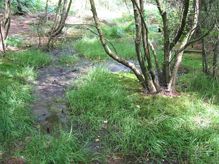
- In 150 metres at a triangular clearing, take the fork left, steeply downhill, your direction 140° [5]. In 90 metres cross a set of planks over a swampy area, to carry straight on, initially downhill then soon uphill.
- In 200 metres at the top of the incline cross a main path and keep ahead, your direction 145°. Go straight on, now downhill, for 100 metres and at a path junction, with a broken fence ahead, [!] turn sharp right onto a narrow path (almost back on yourself) your direction 250°, with young trees on your right-hand side.
- The path soon swings to the left and heads downhill and in 215 metres you come down to T-junction with a stream (dried up in summer) on your left-hand side. [5A] Here turn left on a car-wide bridleway (marked with yellow arrows) uphill, your direction 135°. (Walk 41 – Bow Brickhill to Leighton Buzzard – joins here from the right).
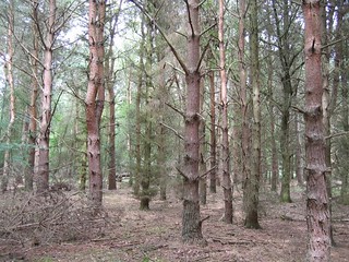
- Head uphill towards the Sierra redwood (Wellingtonia) trees. The path begins to level out after 120 metres and in a further 250 metres, and fifteen metres beyond the end of the wood on your left-hand side, with a clearing to your right, and just before a footpath sign often hidden in undergrowth to your left [!][6] take the rough path with a few remaining earthen steps on your left, steeply uphill, your direction 60°, now with the wood again on your left-hand side. At the top of the slope keep ahead and in 80 metres your onward way soon swings to the right and you keep ahead between post and wire fences, with a maintained green space on your right.
- In 380 metres exit this enclosed path by a redundant stile to turn left onto a tarmac road, your direction 20°.
- In 340 metres you ignore a possible way into the woods on your right-hand side, but in a further 160 metres - 5 metres beyond the entrance driveway to the Woburn Golf Club clubhouse on your left - [!] go through a wooden kissing gate on your right onto a signposted gravelled footpath, a tarmac drive to its right, your direction 105°. [!]Note: For the rest of the walk from this point onwards until you leave Woburn Park in the afternoon the route is well waymarked by wooden posts with yellow tops and black arrows marked WW (Woburn Walk). In these Directions these posts are referred to as marker posts.
- Keep ahead along the right-hand edge of woodland and in 175 metres, with a marker post on your right, as a path joins from the right, keep ahead and in 15 metres follow the public footpath sign ahead, now on a gravel track. In 200 metres, at a path junction, the path swings to the right, with a practice driving range over to your left and golf links to your right, your direction now 145°. Keep ahead and ignore all ways off and path crossings.
- In 350 metres, as the open field (driving range) to the left comes to an end [7], and with a marker post on your right, turn left, on a gravel and grassy car-wide track, with the edge of Charle Wood (as marked on the OS map) on your right, your direction 30°. In 110 metres the car-wide track joins a gravel track coming in from the left and keep ahead, along it, your direction now 50°.
- In 120 metres [!] fork right off the gravel track across grass, following the marker post, your direction 80°, with a house ahead and over to your left. In 75 metres cross an entrance drive and keep ahead. In a further 90 metres you pass the house on your left.
- In a further 75 metres go through an open gateway and continue with the field to your left and the wood to your right, gently downhill, your direction 60°. In 130 metres, by a three-armed footpath sign, continue ahead along a concrete path, in the direction of the marker post. The route is straight on, latterly uphill, and you ignore all ways off.
- In 240 metres, as the concrete path swings left, you exit the wood ahead, to follow the marker post straight across an open field, along the line of the telegraph poles, with a new reservoir and its 1.7 metre high fence to your immediate left. In 175 metres, at the end of the field, ignore the path which swings to the left beside the reservoir fence and instead keep ahead, following the direction of the marker post, down between woods.
- In 220 metres you come to a T-junction, with a stream ahead on the other side of the hedge [8]. Here turn left following the marker post, your direction 20°. In 50 metres [!] turn right over the stream, following the marker post, direction 105° across a field.
- In 220 metres go through a gap in the field boundary and follow the marker post into the next field, a quarter left, your direction 90°.
- In 120 metres go through an archway cut in the hedge and over a wooden footbridge with wooden handrail. Ignore the path ahead and instead [!] turn left, your direction 5°, now with the ditch on your left-hand side.
- In 35 metres follow the marker post right [!] to go diagonally across the field, your direction 75°. Aim for the marker post ahead and in 250 metres you go through a gap in the hedge to continue on into the next open field. In a further 225 metres you go over a wooden footbridge with wooden handrail, then through a kissing gate and keep ahead.
- In 80 metres go over a ditch and through a wooden kissing gate to go half left, your direction due east. In 45 metres go through a new metal kissing gate and up beside the fence of a house on your right-hand side. In 50 metres pass through a barrier and come out onto a road.
- Turn right on this main road (Bedford Street) and up into the town of Woburn. In 100 metres on your left-hand side you pass The Bell Inn, opposite the Bell Hotel, a possible lunch stop. In a further 40 metres on your left-hand side you pass Longs Inn, another possible lunch stop. In a further 120 metres up Bedford Street on your left-hand side is the Black Horse pub, the suggested lunchtime stop.
- Coming out of the Black Horse pub after lunch, turn left, due south. In 35 metres turn left on Park Street, your direction 70°. In 100 metres you come to St Mary, the parish church of Woburn, with its dreadful gargoyles. Continue down Park Street and in 65 metres you enter Woburn Park by the cattle grid and Lion lodge and go half right on a signposted footpath, your direction 115°. Soon you pass a lake over to your left.
- In 450 metres take the tarmac path to the left of cottages nos. 2 and 3 (the ones with mock-Elizabethan chimneys) to go straight on, your direction 105°.
- In 95 metres go through a swing gate to the left of a cattle grid and keep straight on, with the estate’s Bedford office to your right, on a wide tarmac road. In 60 metres pass through traffic barriers, with a timber-framed pavilion with its ha ha over to your left and in 50 metres as the road swings to the right, [!] turn half-left off the road by a marker post, to cross the grass, your initial direction 45° [9].
- At this point you could detour to Woburn Abbey. The detour is along public footpaths, to look at the outside of the Abbey buildings without having to pay the Park entrance fee (but Note: unless you take the 3.7 km walk extension to Potter’s End and Church End via the Greensand Ridge Walk path, you will have to retrace your steps to point [9]
- Detour to view Woburn Abbey : To take the detour, instead of turning half-left off the tarmac road, stay on it as it swings right, with a lake soon on your left-hand side and stables to your right, your direction 195°. Pass the ticket office. In 90 metres, and 5 metres beyond the end of the lake, leave the road to go straight on, following the gravelled farm road marked “No entry”, your direction 210 °. Woburn Abbey is on your far left-hand side. Follow the fence on your right-hand side for 600 metres. When you come to the four-armed footpath sign by a metal swing gate, take the path signposted Greensand Ridge Walk, left, your direction 75°, heading well to the left of the Abbey, following occasional waymark posts on the way. Head on between lakes and across the estate drive, your direction 80°, in 500 metres joining a gravelled road to go straight on, your direction 100 °, with the Abbey garden railings on your right-hand side, to the pedestrian entrance to tearooms on your right. To visit the Abbey you will have to pay the entrance fee. After looking at the Abbey buildings from the outside, or after visiting the Abbey itself, retrace your steps to point [9]. DO NOT try to take a short cut northwards from the Abbey along one of the “No Entry” estate roads; you will be turned back by a Park Ranger.
- Extension Potter’s End and Church End via the Greensand Ridge Walk path : For the 3.7 km walk extension: instead of retracing your steps, you can head east after the tearooms to follow the Greensand Ridge Walk path. Follow the clear signs, or refer to the OS maps the path eventually swings south-east after 1.5 km to the road at Potter’s End, where you head north-east along the road for 400 metres to Church End. You then follow a minor road via Hills End and Froxfield for 1.8 km to rejoin the main walk directions at the cattle grid, point [10] below.
- To continue along the main route: Having turned half-left off the road, at point [9[, cross the grass and in 50 metres you pass the end of the lake on your right. Here your route swings to the right on a well-defined grassy path, your direction due east, initially parallel to a main estate road, 100 metres over to your left, which later converges with your path. Follow the ‘Keep to Public Footpath’ signs and marker posts as you head gently uphill. Herds of deer are usually seen off to the left and right.
- In 825 metres cross a gravel estate road (which heads right to the Abbey) and keep ahead on the grassy path in the same direction as before. In 175 metres the path swings left to cross another estate road with a barrier on your right. Keep ahead on the path, now parallel to the main estate road, just 5 metres to your left.
- In 180 metres, as the road on your left comes to a cattle grid and the grassy path comes to an end, cross the road and take the footpath on your left just before the cattle grid, your direction 20° [10].
- In 30 metres at a path junction [!] take the left fork on a grassy way and keep ahead, mostly uphill, your initial direction north, ignoring all ways off, following marker posts, for 600 metres until your path is parallel to the road on your left beside the Safari Park’s high fencing. Your now follow the grassy path some 3 metres to the right of this road, northwards. The brown bear enclosure is over to your left.
- In 460 metres go over stiles on either side of a cattle grid with Trusslers Hill Lodge on your right-hand side. [11]. In 35 metres [!], by a marker post, turn left on a path downhill, following the line of mini-pylons, your direction 310°, into Hay Wood (as marked on the OS map).
- In 310 metres at the bottom of the path, having passed through some muddy sections, you pass through high metal gates and keep ahead, soon crossing the Safari Park’s entrance drive [12] (with pay kiosks over to your left) to go straight on, your direction 310°, on a tarmac road.
- The footpath ahead has been re-routed away from the Safari Park. It will be well signposted. Follow the new footpath.
- In 100m, pass the Safari Park entrance. In another 200m the path turns left. In 500m it veers to the right as you enter woods. In 400m you come out on to a tarmac estate road where you go right, your direction 345°, rejoining the old route. [This paragraph needs to be walk checked]
In 100 metres, and 20 metres past the end of the quarantine area on your right-hand side, [!] take the signposted public footpath to your left through a wooden kissing gate, your direction 210°.Now follow the path with the Safari Park high fencing on your left. You should be able to see zebra, buck, rhino, bison and later elephants. After 450 metres you pass the elephant house on your right and go through a high woosen kissing gate to go down into a wooded area, your direction 220° (ignoring the path before the kissing gate on your right). You should now see the Rothschild Giraffe compound over to your left.In 40 metres, at the bottom of the slope, follow the sign on a tree to go right and follow the footpath with a stream bed on your left-hand side, your direction 285 °. Keep ahead along this path, muddy in places, through a lightly wooded area, as you pass the wallaby enclosure to your left, then the Go Ape adventure area and other attractions: further over to the left is the Dolphinarium.Ignore all ways off and in 450 metresYou come to a tarmac road where you go right, your direction 345°.350300 metres down this road (where the simplest route is to go straight on, which leads directly out to the Crawley Lodge exit to Woburn Park, you are meant to take the official footpath but if it is wet and or you are in a hurry to get to the walk-end, stay on the road to the Lodge. For the official route [!] fork right off the road by a footpath post, your direction 5°, along a rough and at times overgrown path. In 220 metres you come out to cross a tarmac road (with an earth road to its right). Continue straight on, through a wooded area, towards a (broken) stile, your direction 315 °. In 40 metres cross over or pass by this stile to go left, your direction 275°, along a part fenced-in, rough and at times overgrown path In 125 metres you come out onto the estate road just to the left of a cattle grid in front of Crawley Lodge.- Exit Woburn Park through the gate to the right of the Lodge and turn right onto the main A4012 road, your direction 20°. In 40 metres turn left into Horsepool Lane, your direction 310°, following the sign to Aspley Guise village [13].
- Continue along Horsepool Lane, uphill, towards the village, ignoring all ways off. (There is a public footpath which runs to the left of the lane across agricultural fields and through a lightly wooden area for 500 metres before it rejoins the lane, if you want to avoid road walking). In 1 km you reach the top of the hill and a short distance over the top, you pass on your right-hand side a new residential development on the site of the former Wheatsheaf pub.
- In 200 metres you come to a road T-junction where you turn left, your direction west [14]. In 60 metres you pass two thatched cottages (Park Cottage and Valentine Cottage) on your left-hand side, and in a further 80 metres you cross the road to go through a metal kissing gate on your right-hand side, to follow a signposted public footpath (Pickering Way) uphill, with a wooden fence on your right and a hedge and later a red brick wall on your left, your direction 310°.
- To visit the Anchor Inn For those wishing to have tea before concluding their walk at Aspley Guise railway station, do not take this footpath on the right but instead keep ahead along the road. In approx. 250 metres you come to a village crossroads and the Anchor Inn is on your right-hand side. After tea, head up Church Street, and in some 300 metres you pass St Botolph’s church [14A] on your right-hand side. Continue on for 600m to the station.
- Continuing on the main route: in 250 metres, at the top of the path, go through a gap (the metal gate here is missing, June 2021) and out on to a road T-junction where you go right, your direction 340°. In 70 metres you pass the Parish Church of St Botolph, Aspley Guise, on your right.
- [14A] To finish in Aspley Guise: Keep ahead down this road and in 600 metres you come to Aspley Guise Railway Station on your right.
- Opposite the Parish Church, take the signposted footpath uphill (not into the churchyard) your direction 240°, with the hedge and churchyard on your right [15].
- In 140 metres, you veer right with the path. In 35 metres go through a wooden kissing gate and onwards, on a clear path with an open field on your left and a wooded area to your right, your direction 235°, heading towards some telecom. masts with outbuildings below.
- In 180 metres go through a wooden kissing gate and keep straight on, along a car-wide road. In a further 180 metres you go right through a metal kissing gate marked with a yellow arrow, your direction 285°, into playing fields (West Hill Recreation Ground) towards Milton Keynes. Pass by a children’s playground on your right, and after 135 metres [!] head slightly left to go down to a wooden kissing gate, which you go through onto a golf course.
- Follow the yellow-topped posts over the golf course, your initial direction 330°. In 185 metres you come out on to an earth car road [!] where you go left, your direction 290° [16].
- In 200 metres you pass Golf Course Cottage on your right and a metal shed on your left. In a further 120 metres ignore the road and footpath off to the right [17] by Radwell Farm.
- Continue ahead along the track, soon with golf links to your left and right, and in 260 metres, shortly after the track swings to the left, you exit the golf course and carry straight on, your direction 235°, on Mill Lane. In 80 metres this lane becomes a road between houses on both sides (Burrows Close).
- In 110 metres you cross Weathercock Close to continue straight on, now along a tarmac path, your direction 230°. In 50 metres this path comes out onto the A5130 road, with the Weathercock pub, a tea option, on your right-hand side (if you turn left at this point, in 30 metres you come to the Deep Blue fish and chips shop on your left-hand side).
- To follow the main route: Turn right on the A5130 road, your direction 330°, signposted Wavendon. You pass a new housing development on your left-hand side and in 250 metres you come to the Station Hotel, also on your left-hand side, the suggested tea place.
- Some 30 metres beyond the Station Hotel you come to Woburn Sands Railway Station, with Platform 1 for Bletchley on the near side.